
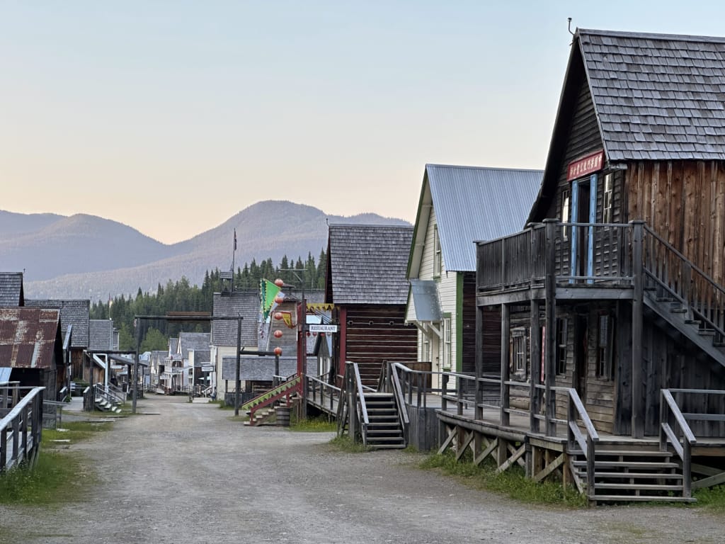
I’ve driven through BC’s Cariboo region a few times to get to other destinations in Northern BC. But recently, I slowed down and did a dedicated Cariboo road trip along Highway 97 to dive into the local Gold Rush Trail history.
The Cariboo is a gorgeous place with rolling hills, ranchlands, and the mighty Fraser River running through it. Today, there is lots of small-town cowboy culture, but the history of the area was shaped by the Gold Rush of the 1860s, so it’s worth making some stops at historic sites, especially Barkerville, a Gold Rush ghost town that is now an immersive museum.
My trip to the Cariboo wasn’t just about history. I also spent time hiking to viewpoints, visiting waterfalls, birdwatching, and even trying fishing for the first time in my life on the aptly named Fishing Highway. And of course, no road trip is complete without recommendations for those hidden gem food stops, so I’ve included those too.
I’ve put together a complete guide to taking a Cariboo road trip along Highway 97 for you. It includes:
- Cariboo road trip at a glance: a quick overview
- A map of BC’s Cariboo region that shows all of the places I mention in this post.
- Best places to stop on a Cariboo road trip: Hikes, food, museums, and more.
- Cariboo travel tips: How to get there? How long to spend? Best time to go? And lots more.
This is a sensitive wilderness area. Learn how to Leave No Trace to keep the wilderness wild. Make sure you are prepared by bringing the 10 Essentials. Get ready for adventure with this checklist of things to do before every hike.
Hey there: Thanks so much to the Cariboo Chilcotin Coast Tourism Association for hosting me during my most recent trip to the Cariboo. All opinions in this post are my own, and previous trips were at my own expense. Some of the links in this post are affiliate links, which means I earn a small commission at no cost to you. Thanks for your support – Taryn
Table of Contents
Cariboo Road Trip at a Glance
Route: Cache Creek to Hixon on Highway 97, with optional extensions
Best for: Road trips, Gold Rush history, fishing, small towns, outdoor adventures
How long: One day for quick stops, 2 to 4 days to see the highlights
Best time to visit: June to September
Map of BC’s Cariboo Region
To help you plan your trip and find your way around, I created a custom Google map of the Cariboo Region for you. It includes every place I mention in this post.

Best Places to Stop on a Cariboo Road Trip
In this section, I’ve got info on all the places I recommend you stop on a Cariboo road trip. I’ve organized them into smaller regions, and listed the stops from south to north as you’d encounter them along Highway 97.
Cache Creek Area
The village of Cache Creek sits at the intersection of Highway 1 (coming from the Fraser Canyon) and Highway 97 (coming from Kamloops). It was an important stop on the Cariboo Wagon Road during the gold rush of the 1850s and 60s, but today it’s much quieter.
Cache Creek is a reliable place to get gas and snacks. But there are a few places just north of town that are worth stopping.
Desert Hills Ranch Taco Stand
Best for: Incredible tacos!
Time needed: 30 minutes
That’s right – tacos! Every year, migrant workers from Mexico come to BC to work as agricultural labourers. Some of them opened the Desert Hills Ranch Taco Stand a few years ago, and it’s crazy good. From what I can tell, it’s quite authentic too. (I’m not an expert, but I have eaten a lot of tacos, and these are the best ones I’ve had in BC.)
My favourite part is the huge self-serve bar of toppings, salsas and other sauces. Many of the salsas are made with local fruit. They are famous for their pork belly taco. I loved it, but it is super fatty, so it isn’t for everyone.
Note: Desert Hills also has another location in nearby Ashcroft that is a farm market only. If you want tacos, you need to go to the Cache Creek location.

Horstings Farm Market
Best for: Pies, fresh produce
Time needed: 20 minutes to 1 hour
There’s always a ton of stuff going on at Horstings Farm Market. They have a huge selection of fresh produce and garden plants. You can pick up made-to-order sandwiches. They have seasonal events like sunflower picking and a pumpkin patch. You can also visit with farm animals like chickens and goats.
But the main reason I go is the pies. They make incredible fruit pies with local fruit like cherries, apples, peaches, and saskatoon berries. I always put at least one fresh pie and make sure I have extra room in my cooler to bring home frozen pies to enjoy later.


Historic Hat Creek Ranch
Best for: Gold rush history
Time needed: 2 to 3 hours
I have to admit I’ve driven past the Historic Hat Creek Ranch quite a few times, but I haven’t had time to visit yet. The ranch sits at the intersection of Highway 97 and Highway 99 (coming from the Sea to Sky Highway).
Hat Creek Ranch was an important part of the original Cariboo Wagon Road. Today it is home to many historic buildings staffed by costumed interpreters. For the last few years, the site has been run by the Secwépemc (Shuswap) Nation and has added lots of important Indigenous context to the exhibits.
You can visit for the day, but they also have overnight accommodation options, too. You can camp, stay in a cabin or opt for a unique stay in a covered wagon.
Clinton
Best for: Antiques, local history, coffee
Time needed: 30 minutes to 2 hours
Highway 97 runs right through the middle of Clinton. It’s a small town, originally founded as a Gold Rush roadhouse. The town was barely spared by the 2026 Big Bar Wildfire, which almost surrounded the town. Today, the area is rebuilding and could use your support.
It’s worth stopping for some food, to browse the antique and vintage stores, or to check out some of the historic buildings.
On my last visit, I spent a fun 30 minutes exploring the exhibits at the Clinton Museum. They have lots of artifacts both inside the museum and in the outdoor area in the back. I loved all the historic photos.
Clinton also has some of the best coffee in the Cariboo at The Junction Coffee House.


100 Mile House Area
100 Mile House is a regional center with a few restaurants, grocery stores, and other shops. It is also home to the world’s largest pair of cross-country skis, located at the Visitor Centre on the side of Highway 97.
Here are a few other places in the 100 Mile House area I recommend:
The Sugar Shack
Best for: Authentic Quebecois maple syrup, poutine, and smoked meat
Time needed: 30 to 45 minutes
Located in 70 Mile House, in between Clinton and 100 Mile House, The Sugar Shack is a must-stop. I drove through 70 Mile House three times last summer, and stopped at The Sugar Shack every time!
They serve breakfast until 11 with lots of maple syrup, but I prefer coming in for lunch so I can get their poutine and one of their amazing smoked meat sandwiches. It’s definitely the best Quebecois food outside of Quebec. They also sell lots of maple products, and I always buy a few cans of maple syrup for my pantry.
On my recent trip, I chatted with Brenda, one of the owners. She started the restaurant with her partner, Robert. They import all of their cheese curds from Quebec, their home province. Brenda told me that she and Robert work 7 days a week in the spring, summer, and fall, then close up shop for the winter so they can head off somewhere warmer.


Mount Begbie Fire Lookout
Best for: Local history, a great viewpoint
Time needed: 30 minutes to 1 hour
These days, forest fires are often spotted by satellites or aircraft. But decades ago, lookout towers perched on top of peaks housed humans with binoculars and radios who were in charge of spotting fires. Most of the lookouts are gone now, but the one on Mount Begbie is still around and is easy to visit.
If you’re heading north on Highway 97 between 70 Mile House and 100 Mile House, you’ll spot the Mount Begbie Fire Lookout on the top of a hill on the right side of the highway. If you want to climb to the top, there’s a short (but steep) trail from a roadside parking area or a slightly less steep dirt road you can walk up.
At the top of the hill, you can climb the stairs into the lookout tower and enjoy the 360-degree views of the surrounding landscape from the windows or the wrap-around deck.


Side Trip to the Fishing Highway
Highway 24, also known as the Fishing Highway or the Interlakes Highway, heads east from Highway 97 to connect with Highway 5. It winds through an interior plateau that is speckled with lots of lakes and ranches. The Highway is a great side trip from the main north-south route through the Cariboo. I also like it as an alternative driving route if I’m heading to Jasper from Vancouver.
The entire Fishing Highway between 93 Mile House on Highway 97 and Little Fort on Highway 5 is 97 km long and takes about 1 hour and 10 minutes to drive.
If you’re looking for a place to stay along the Fishing Highway, I recommend the Sheridan Lake Resort. I spent a night in one of their rustic cabins. Their property is set up for fishing with a boat launch and several docks. It’s also a gorgeous location with great views of the lake. I chatted with the owners, Titus and Tammi, and they were so sweet.
Here are a few things to see and do along the Fishing Highway:

Lone Butte
Best for: Views, local history
Time needed: 15 minutes to 2 hours
The little town of Lone Butte used to be bigger than nearby 100 Mile House. It gets its name from a volcanic rock tower that juts up from the surrounding forest. I found out after I visited that there is actually a rough trail to the top of the butte – I wish I had hiked it!
Beside the butte, the other main thing to see in Lone Butte is the old wooden water tower. Built in 1920, it dates back to the days of the steam engines.
If you’re looking for somewhere to eat in the area, I recommend the Iron Horse Pub. It is located inside a huge log building with vaulted ceilings and has a model train running through the rafters. The food is classic pub fare. I had their famous roadhouse burger, which is made with a bison patty and has onion rings on top. Delicious!

Go Fishing
Time needed: 3 hours to all day
Highway 24 is nicknamed the Fishing Highway because there are over 100 lakes near its route, most of which have great fishing. I have to admit, I had never been fishing before visiting this region. (Okay, once I went fishing in the Strait of Georgia as a teenager, but I was so seasick that I don’t think I ever touched a rod, so it doesn’t count.)
I knew that I had to go fishing along the Fishing Highway, but as a beginner, I wasn’t sure where to start. Thankfully, Mark from Lone Butte Fishing Adventures was able to help. We had to get our own fishing licences, but he took care of everything else.
Mark took us to Sheridan Lake since he thought it would be the best place to fish given the day’s conditions. He took us out in his boat, taught us how to set up the rods and lures, and explained his strategy of trolling the lake to target fish at a specific depth.
I was having fun being out on the water, enjoying the scenery, and chatting with Mark about what it’s like to run a fishing guide business when there was a bite on my line! It all happened pretty quickly, but I reeled it in. I caught my first fish within 30 minutes of getting into the boat! Mark said it was a good-sized rainbow trout for that lake, but I’m no expert! We stayed out for a few more hours and managed to catch another smaller trout.
If you’re in the area, I recommend booking a guide with Lone Butte Fishing Adventures or stopping into Mark’s shop, Lone Butte Sporting Goods, near the Iron Horse Pub for fishing gear and advice. He was so patient with a beginner like me and had lots of helpful tips to share.


Bridge Lake Ice Caves Trail
Best for: Short hike to scenic rock formations
Time needed: 45 minutes to 1.5 hours
The Bridge Lake Ice Caves Trail has been on my to-do list since my husband hiked it last year. The trail leads to a unique set of rock formations and deep crevices (called caves locally) that hold snow and ice late into the summer.
There are 2 kilometres of trails to explore with several viewpoints of the “caves” and views of Bridge Lake. Some of the trails also have outdoor fitness equipment and some Indigenous carvings. The trail to the caves is easy, but the other trails are more rugged, including the Beaver Trail which leads to a swimming area on Bridge Lake.

Williams Lake Area
Williams Lake is one of the biggest towns in the Cariboo (alongside Quesnel), so it is an important regional centre with lots of shops, services, and restaurants.
It’s also known for its cowboy culture and hosts one of the biggest rodeos in Canada. (Apparently, there is also a famous Williams Lake Stampede song from the 1970s.) I haven’t been yet, but I hear that the Museum of the Cariboo-Chilcotin in Williams Lake is also home to the Canadian Cowboy Hall of Fame.
If you’re looking for food, I stopped at Fox Mountain Brewing on one of my trips through Williams Lake. They make great craft beer and also have good pub-style food. Get the smash burger!
Here are a few things I recommend in the Williams Lake area:
Scout Island
Best for: Easy walking, bird watching, nature
Time needed: 30 minutes to 2 hours
Scout Island is located at the west end of the lake. The island has 2.5 kilometres of walking trails through marshes and along the lakeshore. It’s a great place to spot birds. On my visit, I was astonished to spot a flock of about 20 American white pelicans. Apparently, there is a breeding colony nearby! It was so cool.
You can also visit the Scout Island Nature Centre to learn more about the local plants and animals. They also have nature programs for kids.

Xatśūll Heritage Village
Best for: An Indigenous cultural experience
Time needed: 1 to 2 hours
Over the last few years, I’ve tried to learn more about the Indigenous culture and history in the places I visit. That’s why I booked a tour at Xatśūll Heritage Village in Soda Creek just north of Williams Lake.
Pronounced “hat-sooth”, the Xatśūll Heritage Village is an open-air museum with a sweat lodge, teepees, and pit houses. Our guide, Roxanne, took us on a tour of the site to explain the way her ancestors from the Secwépemc Nation have lived since time immemorial and the way they continue to practice their culture today.
Roxanne took us on a walking trail down to the rocky canyon of the Fraser River to show us where her relatives fish for salmon. Along the way, she showed us a petroglyph I would have missed on my own.
We sat on the rocks and listened as she shared stories about reconnecting with her Indigenous culture and how important it was to pass it on to the younger generation. It was a powerful place to sit and reflect as the river roared past.
If you want to visit, I recommend booking a tour in advance. However, Roxanne told me that they hope to have regularly scheduled tours for drop-in visitors soon.


Quesnel Area
Quesnel is one of the biggest cities in the Cariboo and is an important regional centre. The town itself is worth a wander to check out the shops and enjoy the views of the Fraser and Quesnel Rivers, which meet in Quesnel.
In particular, I recommend walking across the Fraser River Footbridge to enjoy the view of the river. The bridge is nearly 100 years old and for years was the only way across the Fraser for hundreds of miles. It used to carry horses and cars, but today it is only open to pedestrians. It is the longest wood truss walking bridge in the world at 253 metres.

Quesnel was an important stop on the Gold Rush Trail and still celebrates its mining history. I happened to be visiting during Billy Barker Days, the community festival held each year in mid-July. There was a huge carnival with rides in the park, live music in the streets, a sidewalk market, and even a rodeo. It seemed like everyone in the Cariboo had shown up to celebrate!

If you need a hotel in Quesnel, I’ve stayed at the Billy Barker Casino Hotel a few times. The exterior is mocked up to look like an old-time Fraser River paddlewheeler boat, which is kind of fun. It is reasonably priced and has a central location, which makes it easy to walk to pretty much everything in Quesnel.
Here are a few more things I recommend in the Quesnel area:
Quesnel Restaurants
If you’re looking for food, I loved Barkerville Brewing Co. I stopped there on my most recent visit to sample the a flight of craft beer and eat a huge plate of their loaded nachos. The staff were really friendly and said they often have live music.

For something different, I’ve stopped at Hannah’s Vietnamese Pho a few times on trips through Quesnel. It’s a casual hole-in-the-wall place with great Vietnamese food at reasonable prices.
If you’re looking for coffee or sandwiches, head to Granville’s Coffee. It’s got a bit of a 90s retro Vancouver coffeehouse theme, which is kind of trippy as a lifelong Vancouverite. The coffee is great though.
Pinnacles Provincial Park
Best for: A short hike with views of hoodoos
Time needed: 30 minutes to 1 hour
Pinnacles Provincial Park is located just outside Quesnel. From the parking area, a flat and easy trail leads for about 1 kilometre to the edge of Baker Creek Canyon. From there, you can follow the trail along the cliff edge to enjoy lots of views of the hoodoos. Just be sure to stay behind the fence!
The story of the hoodoo formation fascinated me. Twelve million years ago, lava cooled over old layers of ash and rock, forming flat basalt rocks. Later, the Ice Age covered the area with glaciers. As the ice receded, the melting water eroded the valley, weathering away the old ash and rock, leaving the flat basalt on top of towering pinnacles. The erosion continues today, so the park may look different each time you visit as some towers fall or change shape.


Hixon Falls
Best for: A short walk to a waterfall
Time needed: 15 to 30 minutes
If you need to stretch your legs on the drive along Highway 97 through the Cariboo between Quesnel and Prince George, I recommend Hixon Falls. It’s a short drive along Hixon Creek Road to the trailhead. The road does turn to gravel partway along, but it is accessible in any car during the summer season.
From the parking area, follow the trail along the creek for a few minutes to the waterfall. The falls drop down the canyon in several tiers. The water was refreshingly cool on a July day, and some people were taking a dip under the lower falls. I just stuck my feet in the water.
Heads up: You can find Hixon Falls on AllTrails, but the directions are written for winter when you have to park down closer to the highway. In the summer, you can drive all the way to the end of the gravel road.

Side Trip to the Barkerville Area
The highlight of my road trip through the Cariboo was the side trip to Barkerville and Wells. The main reason to visit is to go to Barkerville Historic Town & Park, a preserved Gold Rush town. However, there are a few other reasons to make the detour along Highway 24 from Quesnel.
Highway 24 stretches for 86 km from Quesnel to Barkerville and takes about 1 hour and 10 minutes to drive. You can extend the side trip for a further 35 minutes along the gravel Bowron Lake Road to Bowron Lake Provincial Park.
Town of Wells
Best for: Enjoying the arts, exploring a small mining town
Time needed: 30 minutes to 2 hours
Today, Barkerville is preserved as a museum, so no one actually lives there. Instead, about 200 people still live in the nearby town of Wells. Some residents still work in the nearby mines.
But the main reason to visit is to take in the town’s famous arts scene. You can take classes or visit the gallery at Island Mountain Arts or buy tickets to a play or live music performance at the Sunset Theatre. It’s also worth stopping at Frog on the Bog Gifts. It’s really cute and they also have coffee and baked goods.

Barkerville Historic Town & Park
Best for: Immersing yourself in Gold Rush history
Time needed: 4 hours to 2 days
I spent a half day at Barkerville Historic Town & Park a few years ago, and quickly realized that wasn’t enough time, so I came back for a longer visit last summer.
Barkerville is a historic Gold Rush town founded in 1862. Today, over 125 heritage buildings are preserved as a ghost town and immersive museum. You can wander through exhibits in many of the buildings, learn from costumed interpreters, ride a stagecoach, and lots more. Basically, it’s like if Disneyland had a more rustic and history-focused Gold Rush cousin.
There is so much to see and do at Barkerville that I recommend dedicating at least one whole day to your visit. I spent an entire day there from opening to closing and struggled to fit everything in – next time I’d spend two days and have a more relaxed time table. Check the daily schedule you’ll get with your admission to see what’s on each day to plan your visit around tours, shows, and interactive presentations like Victorian schoolhouse lessons or the blacksmith shop.
In general, I think the must-dos are the guided town tour, the Chinatown tour, a meal at one of the on-site restaurants, and a stagecoach ride. The Chinatown tour in particular taught me so much about the history of Chinese immigrants during the Gold Rush from a perspective I had never considered.
I’ve also heard great things about the Richfield Courthouse, but it’s only open a few days a week and wasn’t operating the day I was there. People rave about the daily Theatre Royal performances, and if you love musical theatre, I’m sure you’ll enjoy it. But I found it just okay and wish I had spent my time in the other exhibits instead.
If you can, book a stay at one of the historic guest houses inside the park. It was so cool to be able to explore the townsite after it had closed – it really felt like a ghost town. I also loved being able to go back to our guest house to grab a snack since we had a kitchen.
Other accommodation options include the St. George Hotel, also inside the park, campgrounds just outside the park, and hotels in Wells.


Bowron Lakes Canoe Circuit
Best for: BC’s premier wilderness canoe trip
Time needed: 2 to 8 days
On one of my Cariboo Road Trips, our destination was the Bowron Lakes Canoe Circuit. This multi-day canoe route is considered the best in Western Canada. The full circuit takes about a week to travel as paddlers connect a roughly rectangle-shaped route through 12 lakes. A shorter option involves doing an out-and-back trip on the west side of the circuit in 2 to 4 days.
While I’m mostly a hiker, my time on the Bowron Lakes was memorable since it was so relaxing. I loved the mountain scenery, the wildlife, and the well-equipped campsites. I’ve got a complete guide to the Bowron Lake Canoe Circuit if you want to plan your own trip.


Extending Your Trip Beyond the Cariboo
Every time I’ve driven through the Cariboo, it’s been part of a longer road trip, and I’m guessing that’s the case for most visitors. The Cariboo sits at the intersection of several travel corridors, so here are a few options for extending your trip.
Southwest via Highway 99: Sea to Sky Highway
The route from Lillooet south to Whistler and my hometown of Squamish via the Sea to Sky Highway (Highway 99) is one of my favourite drives. It’s a high mountain route with lots of steep hills and curves, so it’s not the fastest way to get anywhere. But it is incredibly scenic.
From Cache Creek at the south end of the Cariboo, you’ll follow Highway 99 to Lillooet, then head along the remote mountain Duffey Lake Road past famous Joffre Lakes. (Heads up: you need to book a day pass in advance if you want to visit.)
After Joffre Lakes, you’ll go through the small town of Pemberton where you can stop at North Arm Farm for produce or Mount Currie Coffee for a snack.
Next up is Whistler, with lots of sightseeing, hiking, and shopping. From there, it’s about 2 hours to Vancouver. Be sure to allow extra time to stop in Squamish. I think it’s the prettiest stop, but I’m biased because I live here!


South via Highway 1: Fraser Canyon
Another option for heading towards Vancouver from the Cariboo is to follow Highway 1 along the Fraser Canyon. This is a great option if you want to continue your Gold Rush Trail journey since the Fraser Canyon was the original route for the Gold Rush miners.
To take this option, head south from Cache Creek at the south end of the Cariboo onto Highway 1. You’ll follow the Thompson River before reaching its confluence with the Fraser and the start of your Fraser Canyon road trip in the town of Lytton.
Lytton is rebuilding after a devastating wildfire in 2021, but it’s still worth a stop to visit the small but excellent Lytton Chinese History Museum or go whitewater rafting with Kumsheen Rafting.
Further south along the canyon, I recommend stopping at Tuckkwiowhem Village to learn about Indigenous culture, riding the Hell’s Gate Airtram to see whitewater in the canyon, walking across historic Alexandra Bridge, visiting Yale Historic Site, and walking through the railway tunnels at Othello Tunnels near Hope.


North via Highway 97: Prince George and Northern BC
Another option for extending your Cariboo road trip is to head north. From Hixon at the north end of the Cariboo, continue north along Highway 97 to Prince George.
I recently spent a few days in Prince George and was surprised at how much there was to do. I recommend walking the trails at Cottonwood Island Nature Park to find all the hidden tree bark carvings and visiting the Central BC Railway and Forestry Museum to climb inside historic railcars.
If you have time for yet another detour, Ancient Forest/Chun T’oh Whududut Provincial Park is well worth it. It’s about one hour outside of Prince George and protects a unique stand of inland temperate rainforest with lots of giant trees. The trails feature lots of boardwalks, making it easy to explore.
From Prince George you can continue northwest to Prince Rupert to explore BC’s northern port town. Prince Rupert is a great jumping off point for a trip to Haida Gwaii, known as Canada’s Galapagos Islands thanks to their biological diversity. The Nass Valley, home of the Nisaga’a Nation and some unique volcanic landscapes is also nearby.
Another option from Prince George is to continue north along Highway 97 to Tumbler Ridge. It is home to a UNESCO Global Geopark that includes dinosaur fossils and footprints, waterfalls, and lots of great hiking.


Cariboo Road Trip Planning Tips
How Many Days Should You Spend on a Cariboo Road Trip?
While you can drive through the Cariboo from Cache Creek in the south to Hixon in the north in about 4.5 hours without stops, I recommend spending 2 or 3 days on a Cariboo road trip. That’s enough time to see the highlights, including Barkerville. If you want to go on a fishing trip or travel at a slower pace, I recommend 4 to 5 days.
When is the Best Time to Take a Cariboo Road Trip?
Summer is the best time to visit the Cariboo. Late June through early September has the best weather. That’s also when key attractions like Barkerville are open.
However, if you want to go fishing, September and October are ideal. The weather is a little cooler, but the full winter weather hasn’t arrived yet.

How Do You Get to BC’s Cariboo Region?
The Cariboo region is in the middle of British Columbia, so many people visit as part of a longer road trip on Highway 97 heading to Prince George or other parts of Northern BC.
The most common way to get to the Cariboo is by car. Public transportation is limited, so you’ll need a car to get around.
Here are some rough driving times between destinations in the Cariboo and major British Columbia cities:
- Cache Creek (southern edge of the Cariboo) to Hixon (northern edge of the Cariboo): 4.5 hours
- Vancouver to Cache Creek: 4.5 hours via either the Sea to Sky Highway or the Fraser Canyon
- Kamloops to Cache Creek: 1 hour
- Prince George to Hixon: 45 minutes
- Prince Rupert to Hixon: 8.5 hours
If you are flying, Prince George, Kamloops, and Vancouver are the closest airports. They all have rental car options.
You can also take the EBus to the Cariboo on the Kamloops to Prince George route. They have several stops along the way. However, I don’t recommend this option since there is very little public transportation and you’ll need a car to get around.
What is the Weather Like in the Cariboo?
Summer weather in the Cariboo is generally warm, dry, and sunny. You can expect daytime highs of 21°C to 28°C (70°F to 82°F). Nighttime temps drop to around 10°C to 12°C (50°F to mid-50s°F).
It doesn’t rain much in the Cariboo in summer compared to coastal BC. However, afternoon and evening thunderstorms and strong winds are common.
Where to Get Gas, Groceries, and Supplies in the Cariboo?
While the Cariboo has lots of small towns with limited supplies, there are also several large centers. Williams Lake and Quesnel have lots of gas stations, grocery stores, restaurants and other supplies.
Outside of Williams Lake and Quesnel, you’ll find fairly frequent gas stations along Highway 97 in small communities. Grocery stores and other shops are less common and tend to have a smaller selection. Most towns have at least one restaurant, but hours can be limited.

Cell Service in the Cariboo
There is good 5G cell service in most of the Highway 97 corridor through the Cariboo. You may experience pockets of 4G/LTE between communities.
If you venture off Highway 97 onto Highway 26 towards Barkerville or onto Highway 24 (the Fishing Highway), you’ll go through pockets of bad service and no service.
If you have a Canadian cell phone, you’ll get the best service if you are with Telus or Bell (or one of the providers that uses their towers like Koodo, Public Mobile, and Virgin). You will likely have bad signal or no signal if you are with Rogers or one of their partners, including Fido, Chatr, or Videotron.
For international visitors, you’ll be roaming to look for the best signal, which is usually Telus or Bell. If you buy an eSIM, they typically connect to the strongest local signal.
Make sure you look up Google Maps directions in advance and download offline hiking maps from apps like AllTrails or Gaia GPS before you leave a town.
Final Thoughts
The Cariboo definitely doesn’t get as much hype as some of BC’s other regions, and honestly, I think that’s part of the charm. Everything is a bit quieter, and it feels a bit more relaxed. Every time I take a Cariboo road trip, I discover something new that’s a bit off-the-beaten-path. I can’t wait to see what I find the next time I go to the Cariboo… because there will definitely be a next time!
If you’re planning a trip to the Cariboo, here’s what you should read next:
