
The Nass Valley is tucked away in the Northwest corner of British Columbia. It’s the traditional territory of the Nisga’a people and has fascinating Indigenous culture and gorgeous volcanic scenery. On my visit, I found so many things to do in the Nass Valley.
I’ve wanted to visit Nisga’a territory for years after I heard about their incredible volcanos, picturesque hot springs, and beautiful museum. I spent two days in the Nass Valley (which is sometimes also called the Nisga’a Valley) camping, hiking, visiting cultural sites, and soaking up the beauty.
If you’re in Northern BC visiting Haida Gwaii, Prince Rupert, or Terrace, I definitely recommend adding extra time for the Nass Valley. I think it combines the richness of Indigenous culture you can find in Haida Gwaii with the volcanic scenery of Iceland or Wells Gray Provincial Park. And it’s never crowded! I wasn’t sure what to expect before my trip, but now I can say that the Nass Valley is one of my favourite places in BC.
In case you want to visit, I put together a bit guide to the best things to do in the Nass Valley for you. It includes:
- Nass Valley Basics: Where is it? How long to spend? Best time to go? What is the Indigenous and geological context? And lots more.
- Map of the Nass Valley: It includes all the places I mention in this post.
- Best things to do in the Nass Valley: 20 places to stop including museums, waterfalls, hot springs, hikes, villages, viewpoints, and more.
- Where to stay in the Nass Valley including hotels, B&Bs and campgrounds.
- Tips for visiting the Nass Valley: What I wish I had known before my trip.
This is a sensitive wilderness area. Learn how to Leave No Trace to keep the wilderness wild. Make sure you are prepared by bringing the 10 Essentials. Get ready for adventure with this checklist of things to do before every hike.
Hey there: Some of the links in this post are affiliate links, which means I earn a small commission at no cost to you. Thanks for your support. -Taryn
Nass Valley Basics
Where is the Nass Valley?
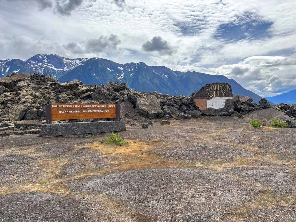
The Nass Valley is located in Northwestern British Columbia about 1.5 hour’s drive north of the city of Terrace on the paved Highway 113. The valley includes four Nisga’a villages and Anhluut’ukwsim Lax̱mihl Angwinga’asanakwhl Nisga’a (Nisga’a Memorial Lava Bed Provincial Park).
It takes about 1.5 hours to drive from one end of the valley to the other because it is 70 km long.
Indigenous Context of the Nass Valley
The Nass Valley is the traditional territory of the Nisga’a Nation who have lived there since time immemorial. Nisga’a society has four tribes: raven, orca, wolf, and eagle. Traditionally, they lived in rectangular cedar long houses.
Like many First Nations in British Columbia, the Canadian government never signed a treaty with the Nisga’a. I used to work as a lawyer and in law school, I studied Indigenous law. (You can read more about my background on my About page.) The Nisga’a have a very important place in Canadian legal history, which was a big reason why I wanted to visit the Nass Valley.
Starting in 1887 with a 1000-kilometre trip to Victoria to meet with the then-Premier, the Nisga’a campaigned for control over their traditional territories. The Nisga’a worked tirelessly to assert their rights and title to their land for decades, despite it being illegal for Indigenous people to raise money for land claims lawsuits between 1927 and 1951. In 1973 the Nisga’a won the Calder case, a landmark Supreme Court of Canada decision that ruled that aboriginal title to land existed before colonization.
Building off of this case, the Nisga’a negotiated with the governments of British Columbia and Canada to sign the Nisga’a Final Agreement that came into effect in 2000 as the first modern treaty between Indigenous people and the governments. Under the agreement, the Nisga’a govern their own territory including education, health care, social services, forestry, fishing, and other aspects of their economy using a model based on traditional Nisga’a governments. Unlike other Indigenous Nations in Canada, they are no longer governed by the Indian Act.
Today the Nisga’a Nation includes about 2,000 people who still live in the Nass Valley as well as about 5,000 others who live in Terrace, Prince Rupert, and Vancouver. They continue their cultural practices and traditions. Nisga’a territory is one of the best places to experience Indigenous tourism in Canada.
Geological Context of the Nass Valley
The other big reason I wanted to visit the Nass Valley was because of the geology. Did you know that one of the most recent (and deadliest) volcanic eruptions in Canada happened in Nisga’a Territory? Tseax Cone erupted in the late 1600s or early 1700s. Lava from the cone flowed down the slope and along the valley of the Tseax River to the Nass River where it spilled out in a wide plain across the valley floor.
Two Nisga’a Villages were destroyed in the eruption as poisonous gases and smoke killed about 2,000 people. Later, lava up to 12 meters deep (39 feet) covered the villages, burying the dead. The name of the present-day provincial park in the area, Nisga’a Memorial Lava Bed Provincial Park, reflects the status of the area sas a memorial and burial ground for those who perished.
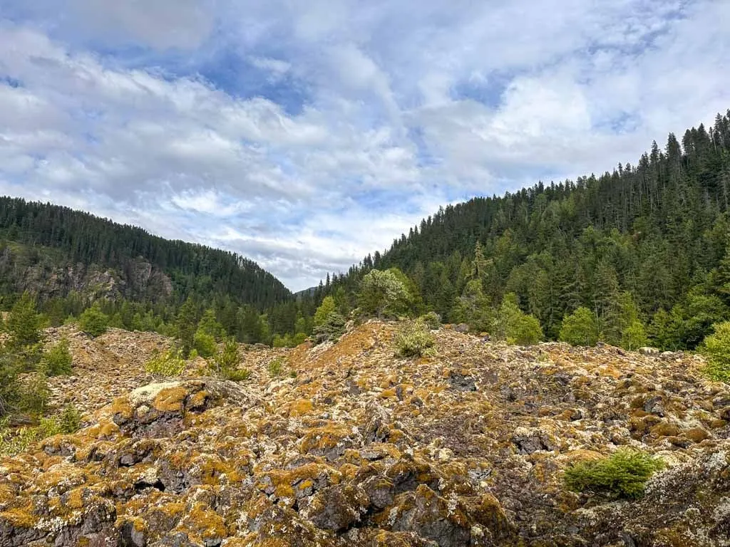
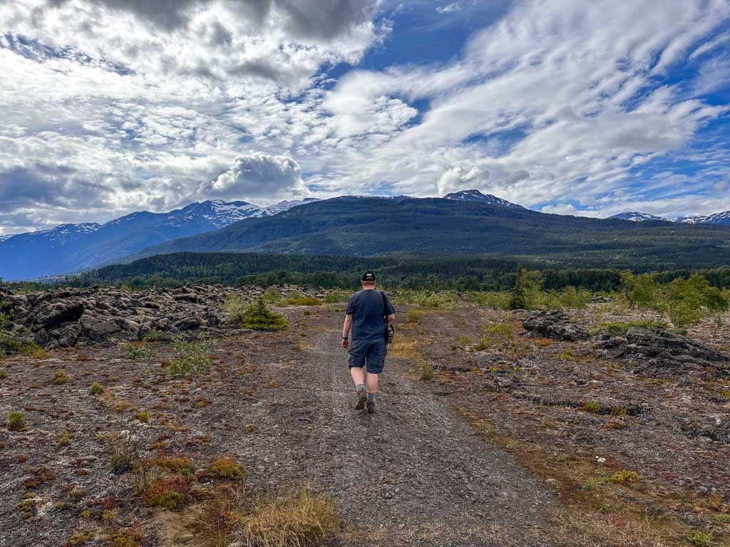
There are lots of lava formations to explore in the valley – it reminded me of similar volcanic landscapes I’ve visited in Iceland and Hawaii. You can wander across the fractured lava plain, see the Nass River churn through a lava rock canyon or take a guided hike to the top of Tseax Cone, the source of the eruption. And of course all that geologic activity means hot springs!

How Long to Spend in the Nass Valley
It’s possible to see the entire Nass Valley in one long day as a day trip from Terrace. However, if you want to see the key sites including the hot springs, museum, and guided volcano hike, I recommend spending two days in the valley.
Best Time to Go
The best time to go to the Nass Valley is between late May and early September. The weather is best at that time of year. As well, that is when the Nisga’a Museum is open every day and the Tseax Cone guided volcano cone hiking tours run.
Weather in the Nass Valley
The Nass Valley is in northwestern BC close to the coast so it has a cool and wet climate. The warmest months are July and August with lows of 10°C (50°F) and highs of 22°C (72°F). May, June and September are a little cooler with temperatures of 5-17°C (41-63°F).
It rains a little bit more at the coastal end of the valley in Gingolx compared to further inland at Gitlax’taamiks (New Aiyansh). The driest months are May, June, July, and August.
Cell Phone Coverage
Cell phone service spotty or non-existent in the Nass Valley. Depending on your carrier, you may get coverage in and around the four Nisga’a villages of Gitlax’taamiks (New Aiyansh), Gitwinksilhkw, Laxgalts’ap, and Gingolx. You will not have service anywhere else.
Gas, Food, Supplies, and Public Washrooms
The villages in the Nass Valley are fairly small and quite remote. The Nisga’a Nation is working on developing tourism infrastructure, but right now, it is fairly limited.
There are gas stations in Gitlax’taamiks (New Aiyansh) and Laxgalts’ap, but it’s a good idea to fill up in Terrace before you drive to Nisga’a Territory.
Gitlax’taamiks has a convenience store at the gas bar with regular hours and there are a few small stores run out of people’s homes in each of the four communities. However, supplies are limited so I recommend bringing everything you will need. You can also eat at the restaurant in Gingolx, but they aren’t always open. As well, if you are staying at a B&B, they can often prepare meals and snacks with advance notice.
There are not very many public washrooms in the valley. You can find pit toilets at Lava Lake, Vetter Falls, the Vetter Creek campground and the Tseax River pull-out. There are flush toilets at the gas bar in Gitlaxt’aamiks, the Nisga’a Museum, and the recreation centres in each village.

Nass Valley Map
To help you find your way around, I made this custom Nass Valley Google Map for you. It includes every single place I mention in this post.

Best Things to Do in the Nass Valley
Since most people will drive through the Nass Valley and Nisga’a Territory from south to northwest along Highway 113, I’ve listed each of the things to do below starting in the south and finishing in the northwest at the end of the highway.
If you are just looking to hit the highlights, here are my quick top five things to do in the Nass Valley:
- Take a guided hike to the Tseax Cone Volcano
- Walk over the Ukws-Ts’agat Suspension Bridge in Gitwinksihlkw
- Hike to the Saasak’ Viewpoint in Gitwinksihlkw
- Soak in Higu Isgwit Hot Springs
- Visit the Nisga’a Museum in Laxgalts’ap
Nisga’a Auto Tour
The easiest way to see the entire area is to follow the Nisga’a Auto Tour. The 90-kilometre-long route follows Highway 113 from the start of Nisga’a Territory at Lava Lake to the Nass River, and then to the coast at Gingolx.

There are 18 designated stops along the Nisga’a Auto Tour, most of which have interpretive signs. The Nisga’a Lisims Government developed the tour as a way to highlight the natural and cultural features of their territory.
Many of the stops are within Nisga’a Memorial Lava Bed Provincial Park, also called Anhluut’ukwsim Lax̱mihl Angwinga’asanakwhl Nisga’a.
You can follow the tour by pulling over whenever you see a sign, or by picking up a copy of the official auto tour brochure. I used a pdf copy of the brochure on my phone on my trip.

Most of the attractions I list below are on the auto tour route, so keep an eye out as you drive. But you will also want to enjoy the spectacular scenery.
The first part of the tour is through the forest, but after you pass Vetter Falls, you emerge onto an other-worldly lava plain. A few minutes past the turn-off for Gitwinksihlkw, the road goes back into the forest and parallels the meandering Nass River, which is out of sight to your right. Watch for wildlife through here – we spotted several black bears!
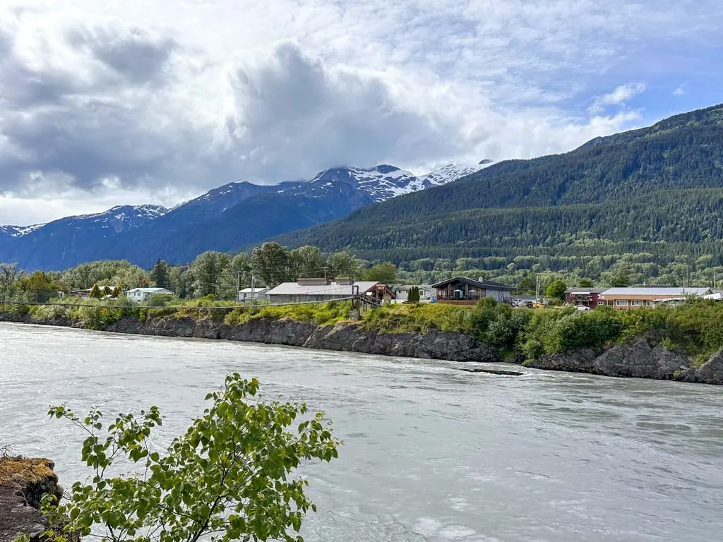
The road curves and crosses the Nass River on a huge bridge then continues through the forest past Laxgalts’ap and the Nisga’a Museum. From here, the highway heads towards the mouth of the Nass River as it empties into the ocean.
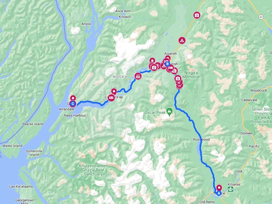
The final 28 km of road was built in 2002. Before that, the only way to get to Gingolx was by boat. This section of the highway has several steep hills and lots of great views of the Nass Rive, Nass Bay, and Portland Inlet.
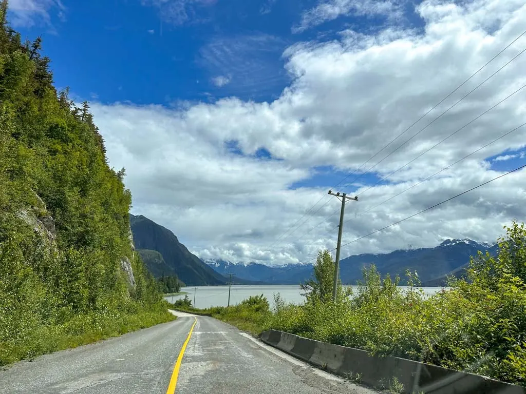
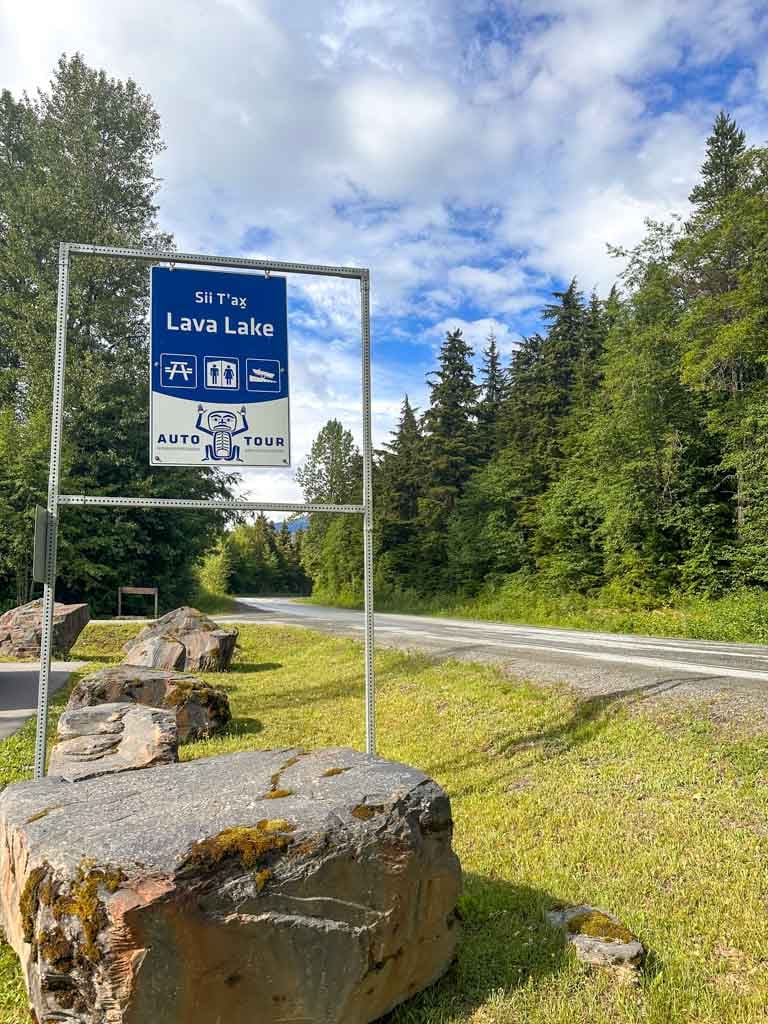
Lava Lake
As you approach from Terrace, the road follows the shore of Lava Lake, known as Sii T’ax in Nisga’a. There are great views from the road and a few small pull-outs to get a better look.
You can also stop at the far end of the lake at the Lava Lake picnic area in Nisga’a Memorial Lava Bed Provincial Park. This is the first stop on the Nisga’a auto tour and there are signs in English and Nisga’a explaining the cultural and geologic significance of the Nass Valley.

During the volcanic eruption in the 1700s, lava flowing down from Tseax Cone dammed the Tseax River, causing water to build up behind it, which formed Lava Lake. From the picnic area, walk down to the shoreline to marvel at the jagged volcanic rocks at the end of the lake.
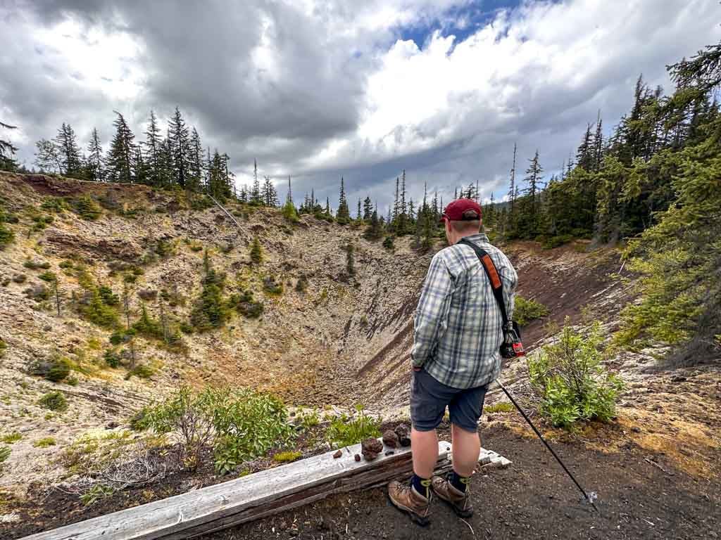
Crater Creek Trail
Find the trailhead for this hike on the right side of the road. A rough path leads through the jumbled lava to a viewpoint. The trail is only 600 m long and takes 15-20 minutes to walk.
Crater Creek (called Ksi Wil Ksi-Baxhl Mihl in Nisga’a) is the start of the lava flow that cascaded down from Tseax Cone before running down the Tseax River valley and burying two Nisga’a villages. As you walk, be careful not to step on the fragile lichens. These tenacious moss-like organisms are the first plants to grow in the lava fields.

Tseax Cone Volcano Tour
One of the highlights of my visit to the Nisga’a Valley was the Tseax Cone Volcano Tour. Tseax Cone (also called Lava Cone) is the origin point of the lava flows from the eruptions in the 1700s. The area is closed to the public, so the only way to visit is on a guided tour.
Steve Johnson, a local Nisga’a man, owns and operates Nass Valley Tours and is the only licenced tour operator for Tseax Cone. He offers tours a few days a week between late June and early September. You can find tour dates and times on his website. Or ask about tour times at the Nisga’a Memorial Lava Bed Visitor Centre at the Vetter Creek Campground.
You don’t need to pre-register for tours – instead just show up at the meeting point, which is a gated road on the right side of Highway 113 about 1.4 km north of Lava Lake. Bring cash to pay your guide. In 2023, the rate was $40/adult or $30/senior or student.
The hike is about 6 km long and takes 3.5 to 4.5 hours. The first part of the hike is downhill, then you climb uphill to the top of the cone. I would rate the difficulty of the hike as moderate.

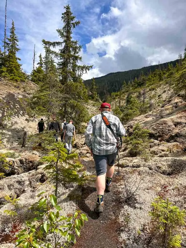
The hike starts in the forest, passes a unique lake dammed by lava, and then emerges from the trees onto the rocky cone. Steve makes several stops along the way to explain Nisga’a cultural practices and oral history as well as give info about the plants and geology. At the peak of the cone he also shared the Nisga’a legend that explains the eruption.
Be sure to look up the tour schedule in advance and plan your visit to the Nass Valley so that you can take the Tseax Cone guided hike. I am so glad we did as the volcanic history was amazing and Steve was a great guide. I loved how he helped us connect what we were seeing on the land to the Nisga’a culture.
Drowned Forest
The next stop after Tseax Cone is the Drowned Forest (called Dihlaa Nii-Baxhl Aks Sbayt-Gan in Nisga’a). I visited in late June when water levels were high and we could see the Tseax River flowing right through the forest here. The lava rocks are full of holes so the river can easily go underground. There is a short walking path that leads to a viewpoint next to the river. You can also see more of the drowned forest from the highway as you drive past.

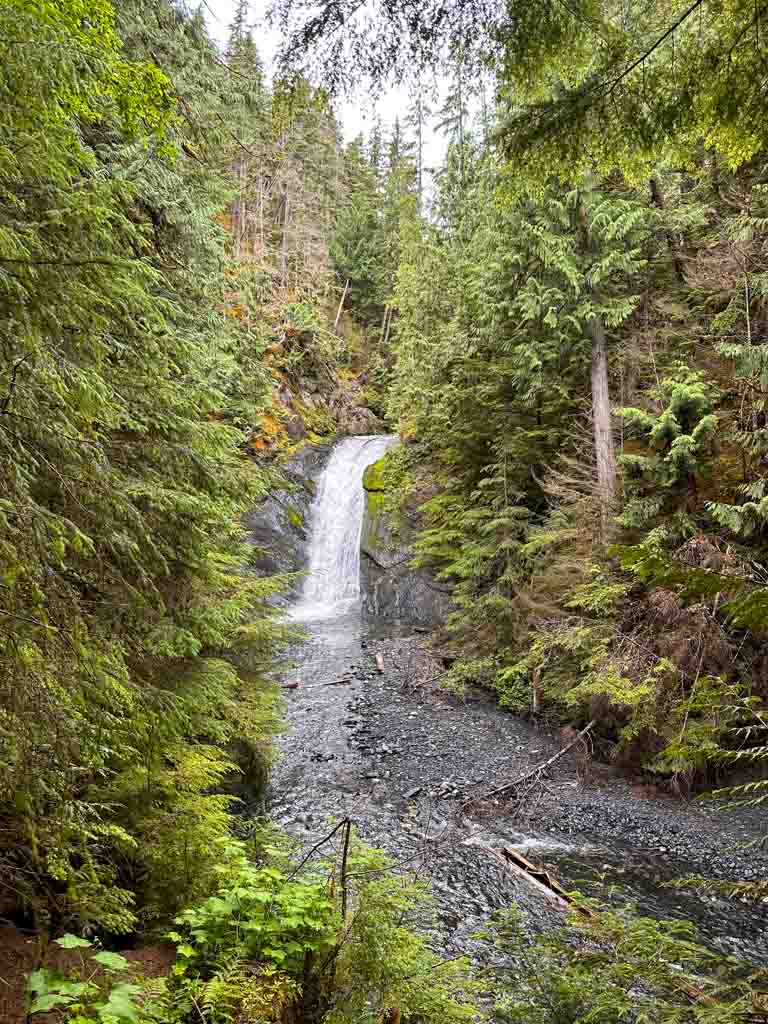
Beaupre Falls
The walk to Beaupre Falls is fairly short and so is the waterfall, but it is still really pretty. It takes about 5 minutes to walk to the falls and back. There is a small viewing area that makes for a great photo op.

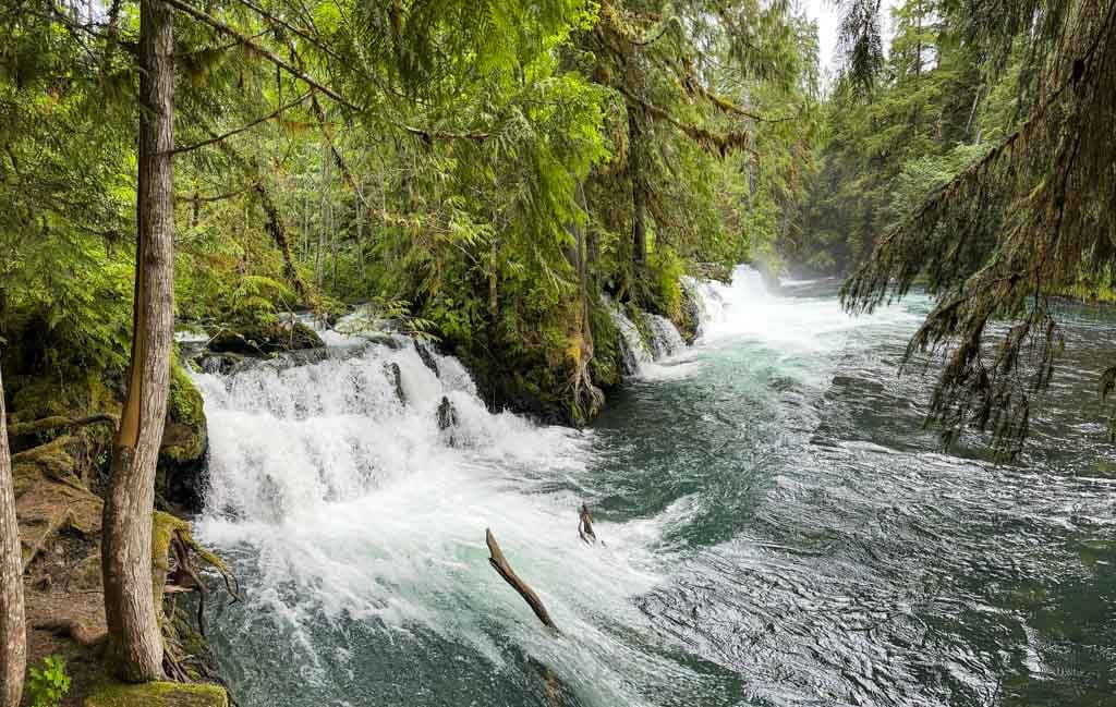
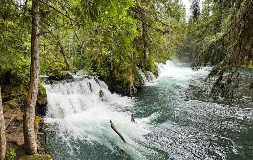
Vetter Falls
While Beaupre Falls is a class cascading waterfall in a forested canyon, Vetter Falls is a bit more unusual. Called Ts’itksim Aks in Nisga’a, the falls flow across the lava, forming a wide waterfall that is separated into three or four sections (depending on flow levels). The best view is from the main viewing platform. Allow 15 minutes for the walk.
Nisga’a Memorial Lava Bed Visitor Centre
Known as Wilp T’aam Lax Sankw’ax in Nisga’a, this visitor centre is located at the entrance to Vetter Creek Campground in Nisga’a Memorial Lava Bed Provincial Park. (The park is also called Anhluut’ukwsim Lax̱mihl Angwinga’asanakwhl Nisga’a in the Nisga’a language.)
The visitor centre is open daily in the summer and staff can help answer questions about the Nass Valley. But it’s worth visiting just to see the beautiful building. The building is designed to look like a traditional cedar Nisga’a longhouse.
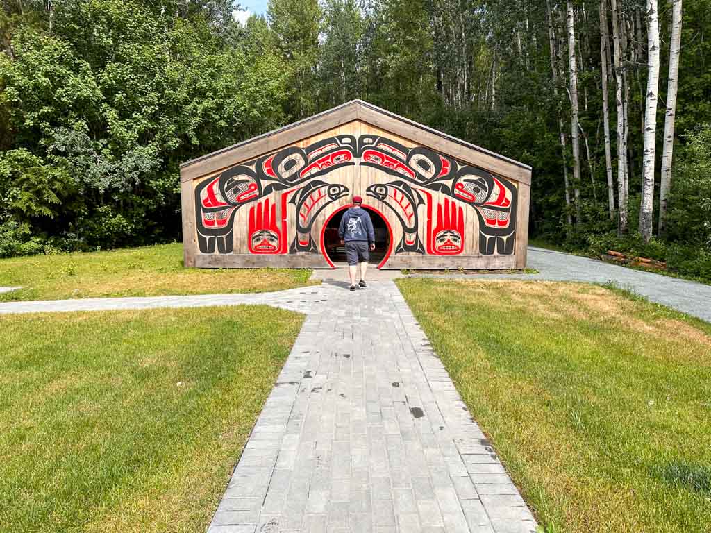
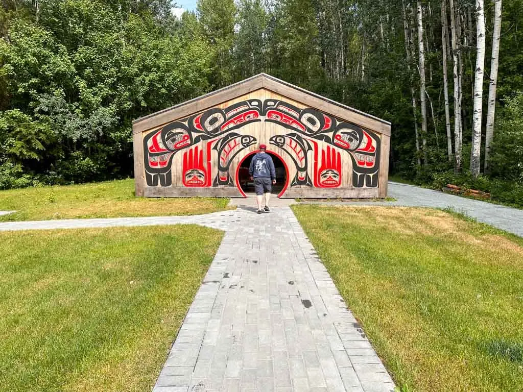
Inside, displays explain Nisga’a culture and history, including the important 2000 Nisga’a Final Agreement, which gave the Nisga’a powers of self-governance.
Gitlax’taamiks (New Aiyansh)
The village of Gitlax’taamiks, formerly known as New Aiyansh, is the first of four Nisga’a villages in the Nass Valley. It is located a few minutes east (right) of the major T-junction on Highway 113. It is pronounced “git-lax-taa-meeks”.
Gitlax’taamiks is the capital of the Nisga’a Nation so you will find the impressive Nisga’a Lisims government building here. The village has a population of about 1000.
In Nisga’a, Gitlax’taamiks means “people of the ponds”. The old name of the town, New Aiyansh meant “fertile valley” and was a reference to the original riverside location of the town of Aiyansh, which was destroyed by flooding in 1917 and 1961.

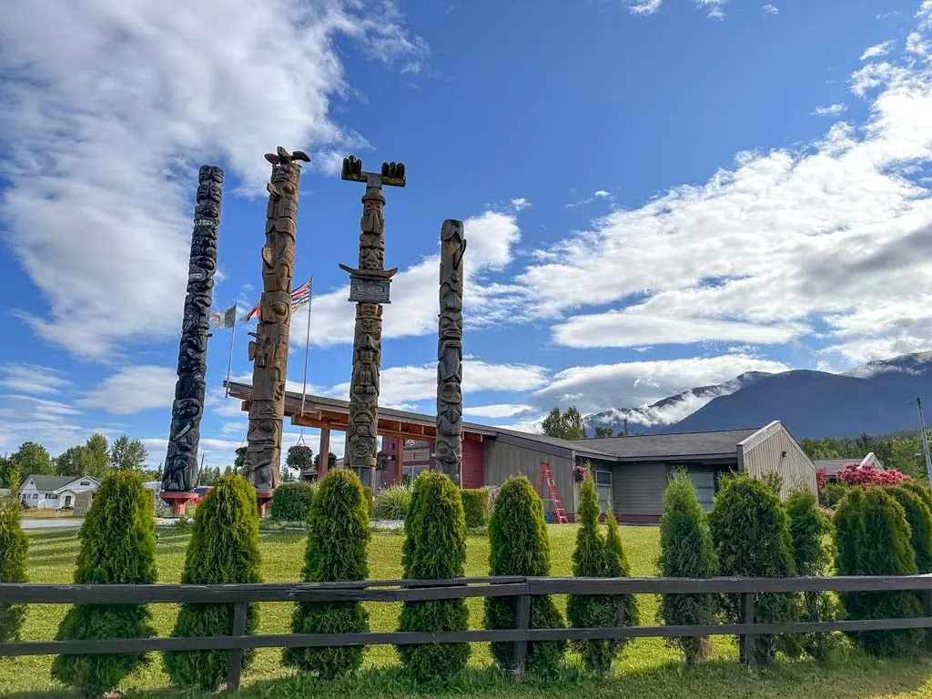
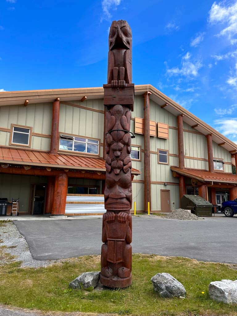
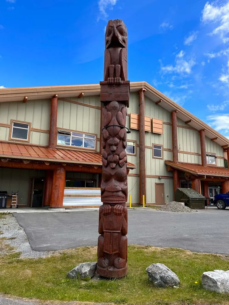
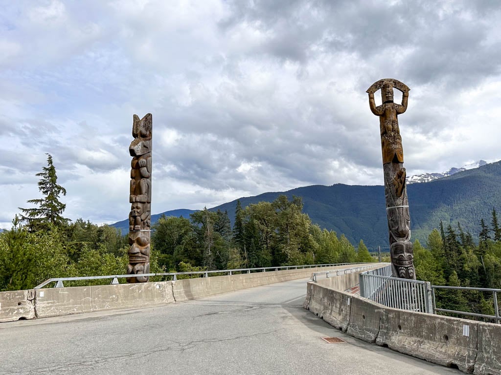
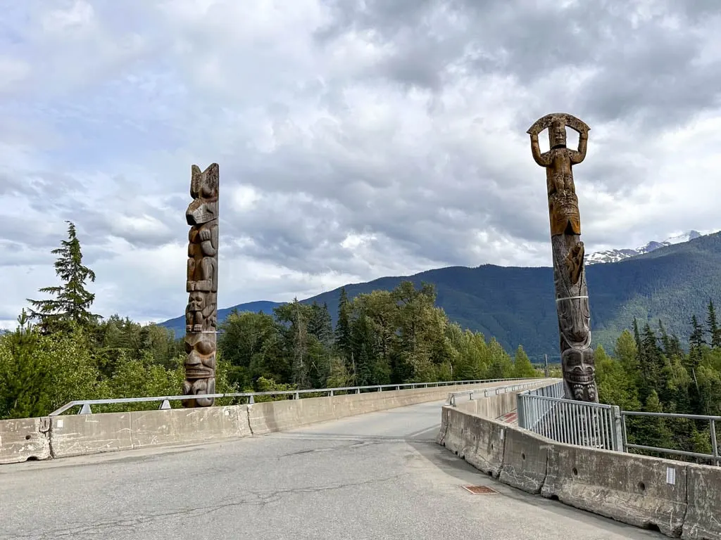
Gitlax’taamiks is worth a visit to see the totem poles (called pts’aan in Nisga’a). You can also request a tour of the Nisga’a Lisims government building, but they were closed on the day I visited.
If you need gas or supplies, stop at the New Aiyansh Gas Bar near the entrance to town.
Nass Forest Service Road to Cranberry Junction
If you continue east past Gitlax’taamiks, Highway 113 becomes the gravel Nass Forest Service Road. This road is muddy and bumpy, but fine for 2WD vehicles. It is 51 km from the end of the pavement to Cranberry Junction on the Stewart-Cassiar Highway (Highway 37). That makes it an alternate exit from the Nass Valley if you don’t want to return to Terrace the way you came.
Along the way, you will pass Dragon Lake. It has a free campground and locals told us it has good fishing for rainbow trout. The rest of the road has a few views of the Nass River.
But the real reason we chose to drive the Nass Forest Service Road is because we heard it was a good place to spot wildlife. I am happy to report we saw a cow moose! Sadly, I didn’t get any photos as she moved too fast and it was pouring rain.
Tree Cast
This roadside pull-out is the start of a 5-minute walk. When the lava solidified around trees, the wet wood burned slower, creating hollows in the rock in the shape of the old tree trunks. In Nisga’a, this area is called Wil Luu-galksi-mihl Gan.
The path starts out wide and straightforward, but within a few minutes, it gets much less distinct. It’s easy to lose the route in the lava, which in some places is so smooth it looks like a sidewalk. In general, follow cleared areas in the lava straight and slightly to the left until you see the tree cast in a depression on your left.

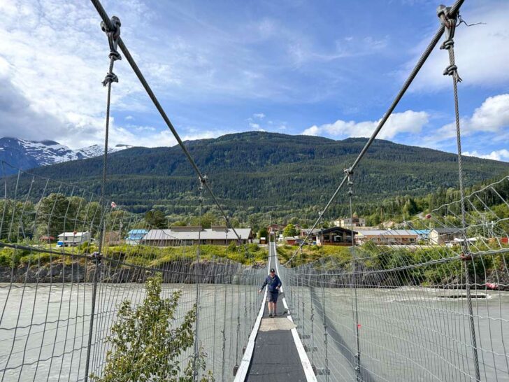
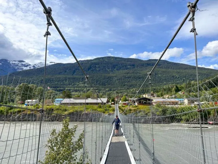
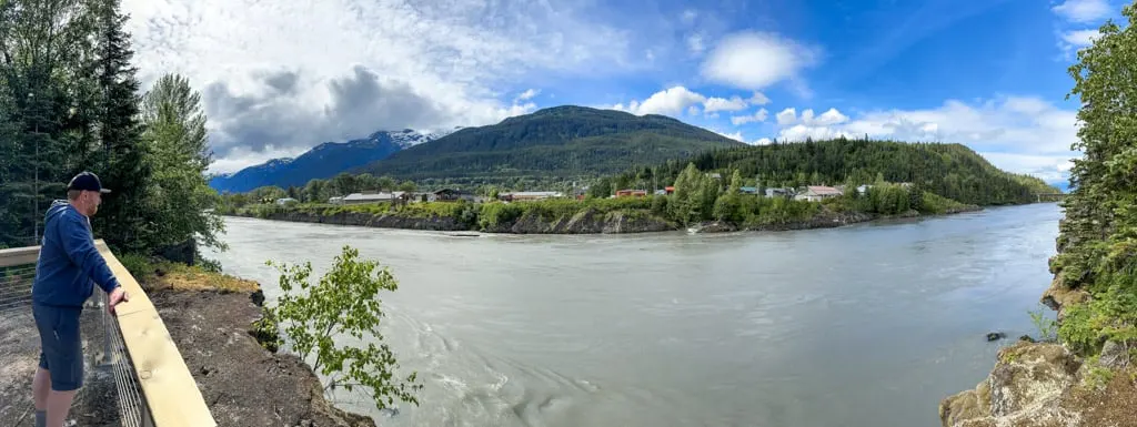
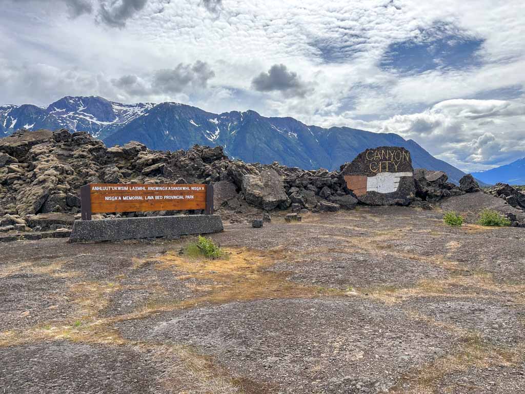
Gitwinksihlkw
Formerly known as Canyon City, Gitwinkshilkw is one of the four Nisga’a villages in the Nass Valley. The name of the town is pronounced GIT-wink-silk and means place of the lizards because, before the eruption, there were lots of salamanders (ksilkw) here.
Gitwinksihlkw has a unique location on the banks of a lava rock canyon with the Nass River running past it. Today a spur road and modern bridge connect the town to Highway 113. But until the 1990s, the only way to get to Gitwinksihlkw was to walk over a suspension bridge (more on that below).

Like the other towns in the Nass Valley, Gitwinksihlkw is small. Be sure to stop to admire the totem poles at the road bridge as well as the ones in front of Ts’oohl Ts’ap Recreation Centre at the back of the village. If it’s open, you can also stop at the Welcome House Cafe and Gift Shop, next to the suspension bridge. I visited in the late afternoon after it had closed for the day 🙁
Ukws-Ts’agat Suspension Bridge
Walking across the Ukws-Ts’agat Suspension Bridge in Gitwinksihlkw was one of my favourite things to do in the Nass Valley. The old bridge was built in 1969, but there have been bridges across the Nass River in this area for hundreds of years. Until the road bridge was built in the 1990s, everything arrived in Gitwinksihlkw via this bridge – people, groceries, building materials, everything!
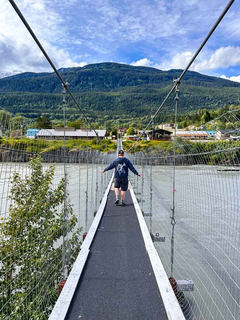

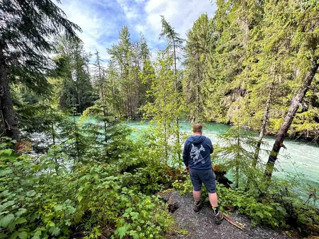
The swinging suspension bridge also provides a great view of the lava canyon. Lava from the eruption in the 1700s changed the course of the Nass River by pushing it north. Today the waters cut a canyon through the lava rock, which is fascinating to see from the bridge.
You can also see giant fish wheels in the water below the bridge. The Nisga’a manage their own fisheries in partnership with the Canadian and British Columbia governments. These fish wheels collect salmon and steelhead for monitoring, tagging, and data collection.
Once you cross the bridge, you arrive at an open area at the end of a dirt road. This used to the be main road entrance to Gitwinksihlkw. From here you can also follow trails along the edge of the canyon to several viewpoints.

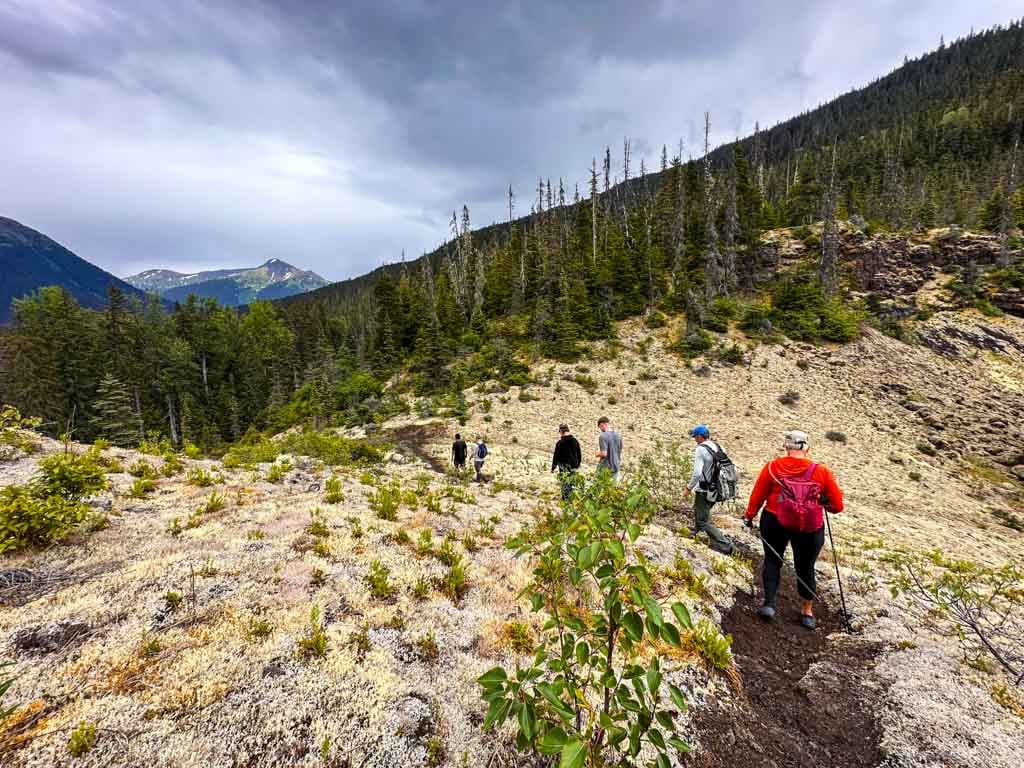
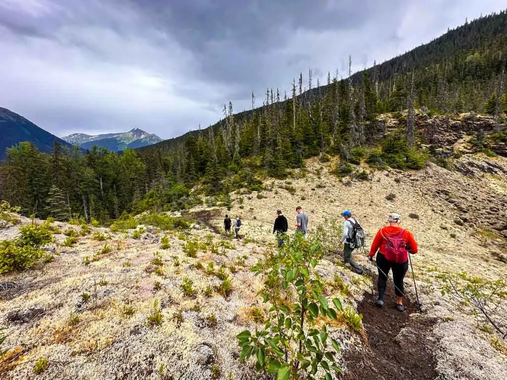
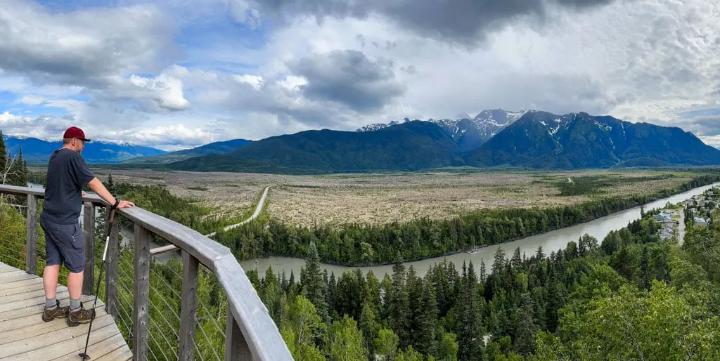
Saasak’ Trails
One of the best places to get a good perspective on the size of the lava flows in the Nass Valley is from the Saasak’ Trails. This trail network opened next to the Ts’oohl Ts’ap Recreation Centre in Gitwinksihlkw in 2021. While the trails were built for mountain biking, they are multi-use and open to hikers too.
There are three trails in the lower part of the network (Saasak’ Hill Climb, a green downhill trail and a blue downhill trail) and four more upper trails accessed via a gravel road (two climb trails as well as a blue trail and a black trail). Use the maps on the Trailforks mountain biking app to find your way.
Both hikers and mountain bikers shouldn’t miss a trip to Saasak’ Viewpoint, accessed via the Saasak’ Hill Climb Trail. The wooden viewing platform has the best view of the Nass Valley.
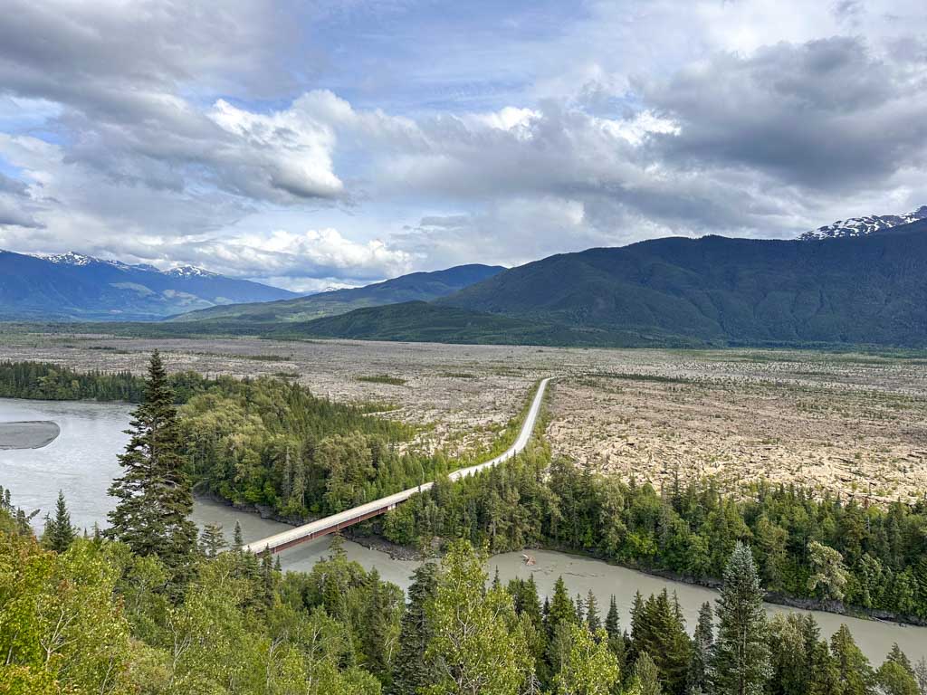
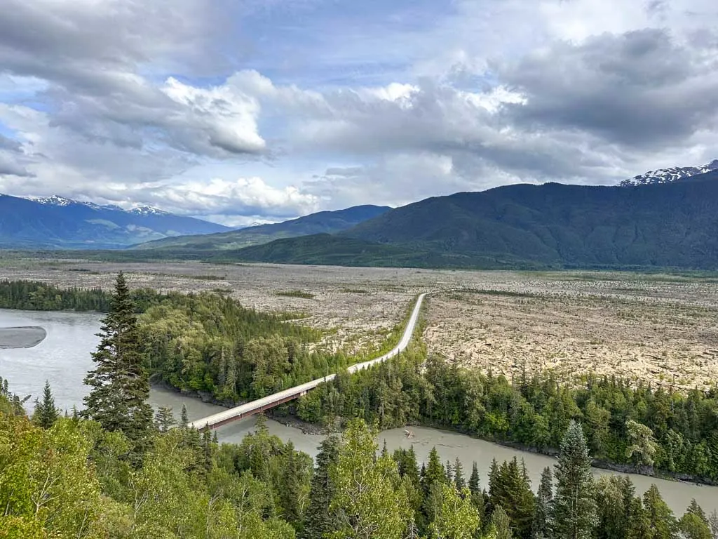
You can see Gitwinksihlkw below you along with the Nass Valley canyon. You can also see how the lava flowed down the Tseax River into the Nass Valley and spread out to create kilometres of flat, unforested lava plain. I didn’t appreciate how vast the lava plain was until I saw it from above!
Anhluut’ukwsim Lax-mihl / Dedication Site
This roadside pullout is a good place to stop and explore the lava. The smooth and sometimes ropey rock formations here are called pahoehoe. They form when lava cools slowly as it continues to flow. This spot is also the place where the Nisga’a Lava Bed Memorial Provincial Park (Anhluut’ukwsim Lax-mihl Angwinga’asa’anskwhl Nisga’a) was formally dedicated in 1992.
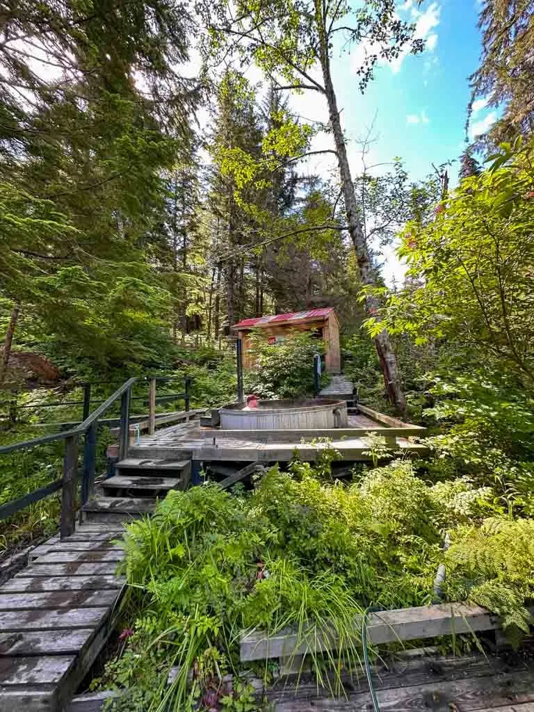
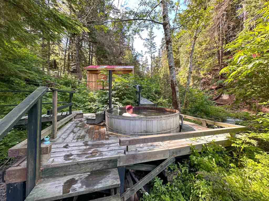
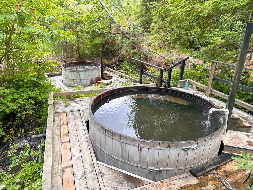
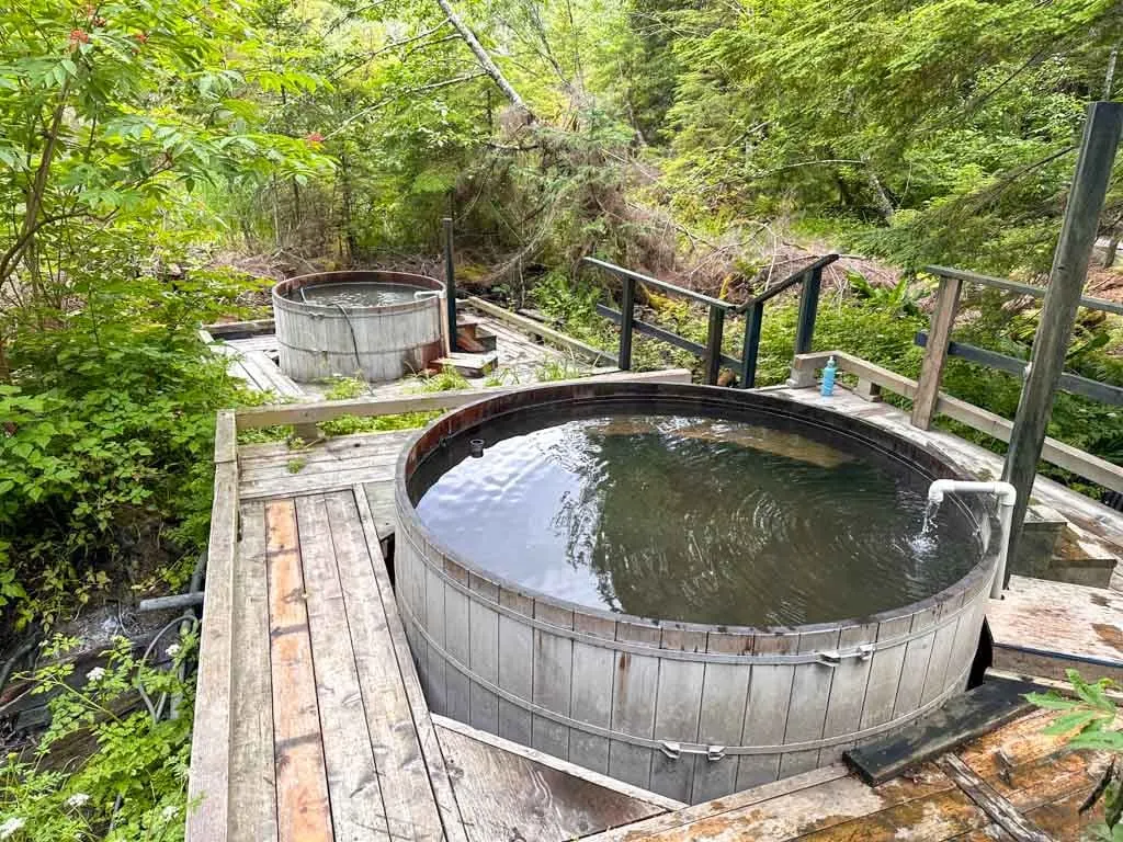
Higu Isgwit Nass Valley Hot Springs
I love hot springs, so visiting the Higu Isgwit Nass Valley Hot Springs was one of the main reasons I wanted to the Nisga’a Valley. (See my guide to hot springs in Canada for lots more great hot springs!)
The springs are often referred to as Aiyansh Hot Springs or Nass Valley Hot Springs. But in Nisga’a they are called Higu Isgwit, which means “little stinker”, a reference to the sulphur smell. The springs are the dwelling place of a spirit (sbi naxnok) and have been culturally significant to the Nisga’a since time immemorial, so be respectful when you visit. Drugs, alcohol, and pets are prohibited. Pack out all garbage and keep noise to a minimum.

You must book in advance by calling (250) 633-3038. They are open for 1-hour sessions between 9:30 am and 4 pm Monday to Friday only. When you call, have your name, email address, phone number, and number of people ready. It costs $8 per adult and $5 per child. You can pay via credit or debit card at the springs – they do not accept cash.
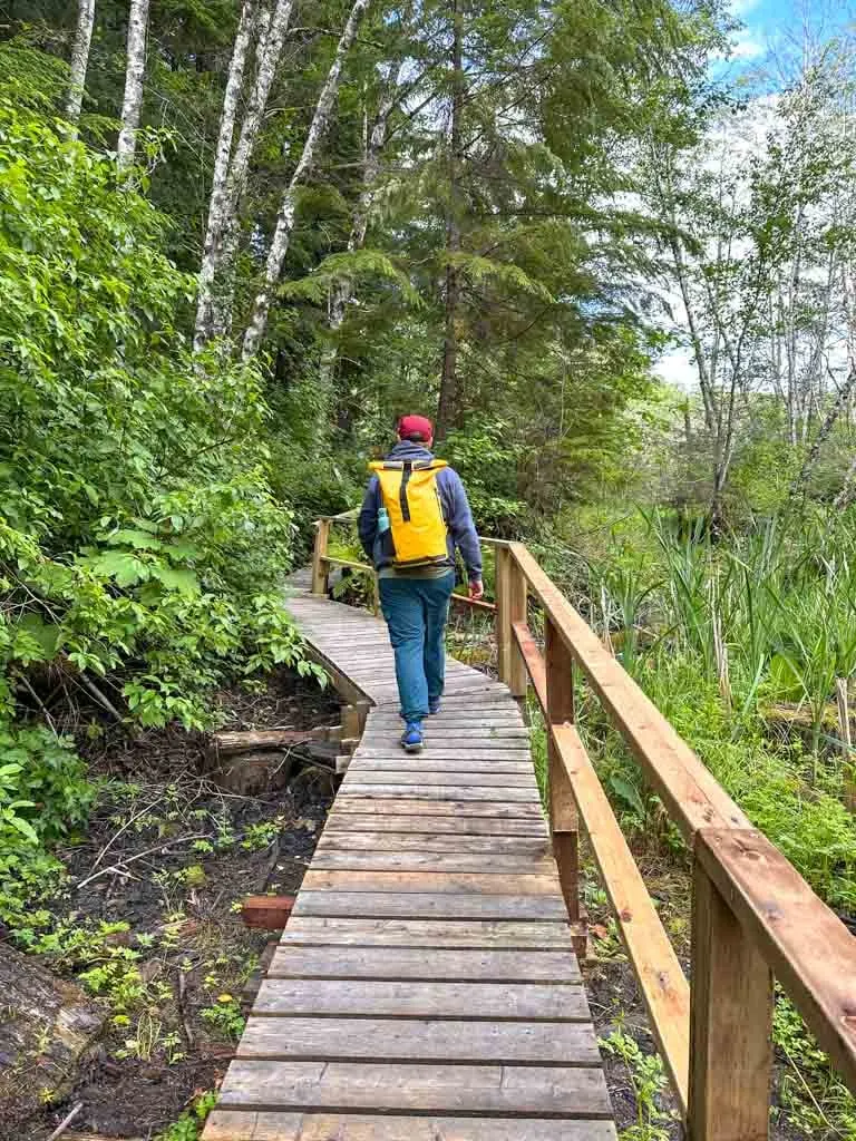
To reach the springs, you will walk along a boardwalk for about five minutes through a marsh. The springs are located in a boggy area near a creek. There is a change room at the springs but no bathrooms – use the pit toilet in the parking lot before you go. The area around the springs can be buggy in June and July.

There are two wooden tubs along with a gravel-bottomed pool. The water in all three is quite hot, but you can adjust the temperature with cold water hoses.
Laxgalts’ap
Laxgalts’ap is the third Nisga’a Village you can visit in the Nass Valley. In Nisga’a, its name means “village on village” since it is built on top of the site of a much older village. It has a small population of about 250 people. For a few decades, Laxgalts’ap was known as Greenville, after a Methodist missionary who worked in the Nass Valley.
Today, the main attraction in Laxgalts’ap is the Nisga’a Museum located just west of town. The town is located at the start of the Nass River estuary, a prime spawning area for salmon and oolichan. You can drive through the village to the banks of the Nass River to watch people fishing.
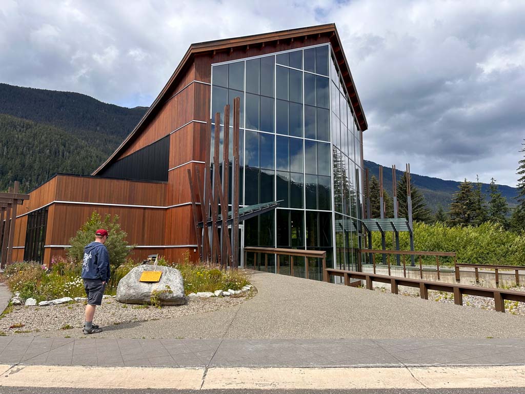
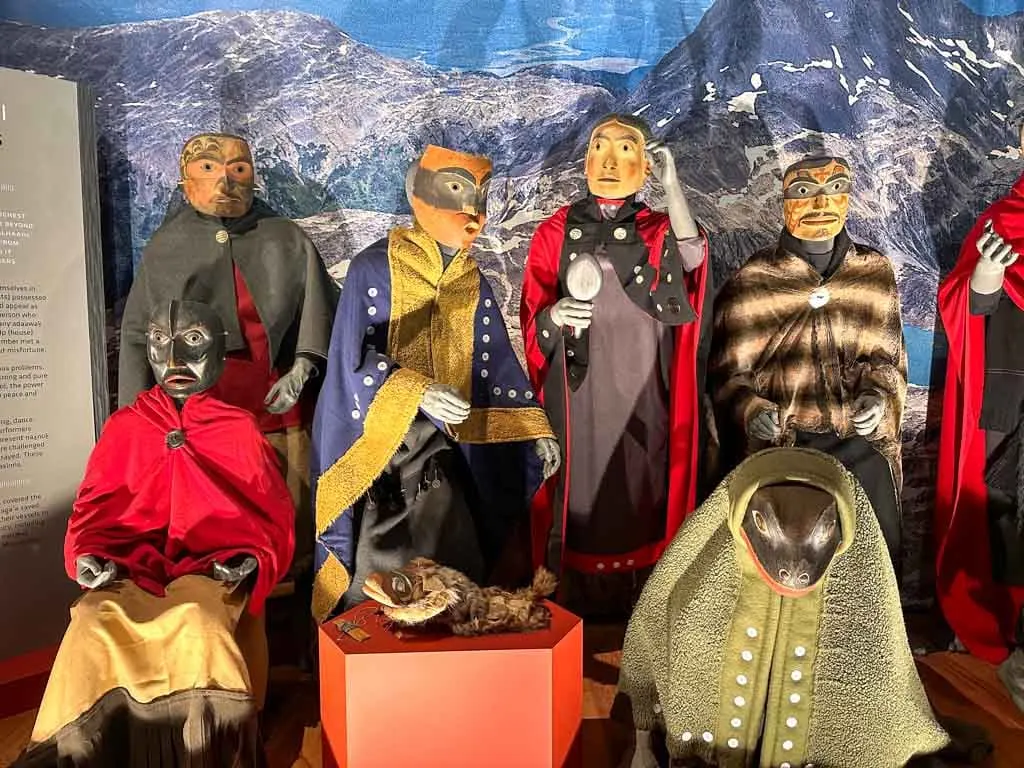
Nisga’a Museum
The Nisga’a Museum is also known as Hli Goothl Wilp-Adokshl Nisga’a which means “The Heart of Nisga’a House Crests”. The museum has a huge collection of totem poles, carvings, canoes, regalia and other cultural objects. I’ve visited Indigenous museums in Whistler, Haida Gwaii, and Alert Bay, and I thought the Nisga’a Museum had one of the best collections.
A free guided tour is included with museum entry. I took a tour with two young Nisga’a women. They did a great job of answering my questions and explaining the exhibits.
The first thing you notice when you walk into the museum is the soaring totem poles and the carved house front. They actually designed the museum with enough room to add another pole. After a decades-long campaign, the stolen Ni’isjoohl memorial pole was finally returned from a museum in Scotland and installed in the museum a few months after I visited.

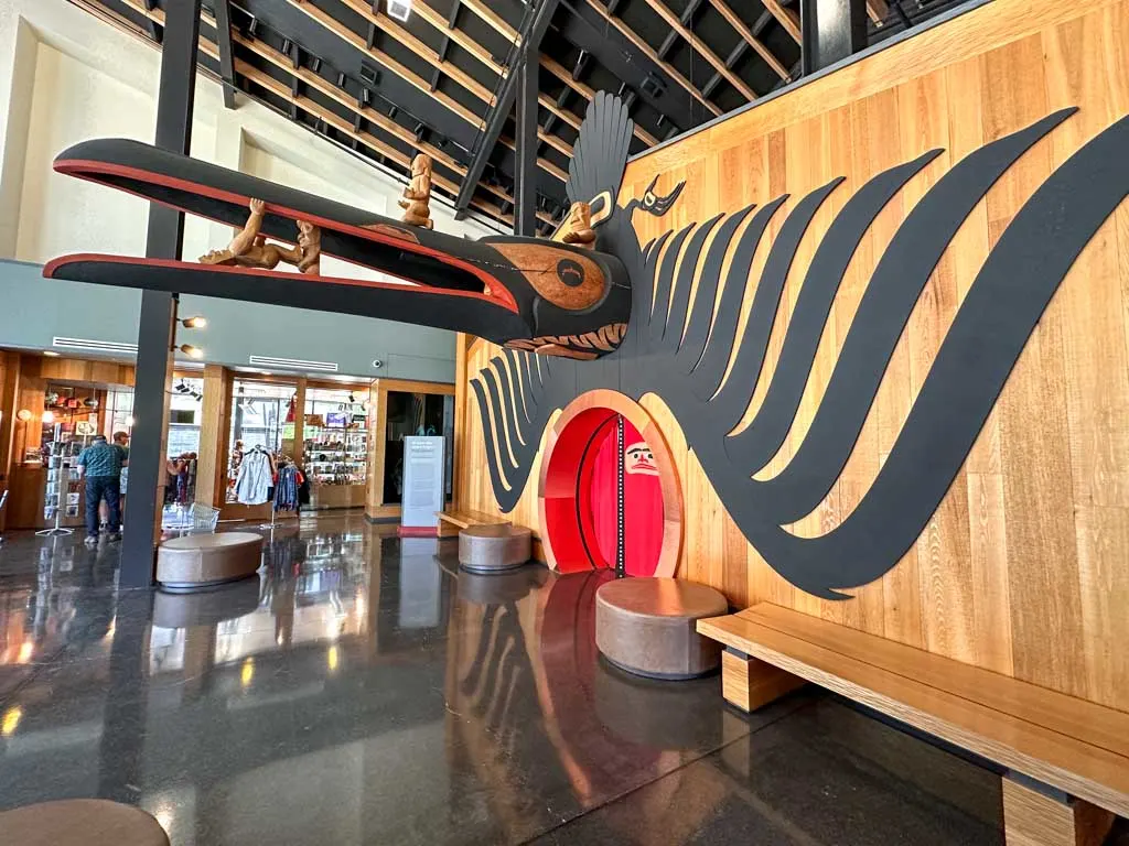
Many of the other exhibits in the museum are also rematriated items, returned to the Nisga’a from museums around the world. (The Nisga’a use the word “rematriation” rather than “repatriation” since they are a matrilineal culture.) These returned ceremonial objects are now on display in the Ancestors Collection gallery.

The museum is open seven days a week in July, August, and early September and from Wednesday to Sunday in late May, June, most of September and early October. Make sure to plan your visit for a time when the museum is open. They also have a great gift shop.
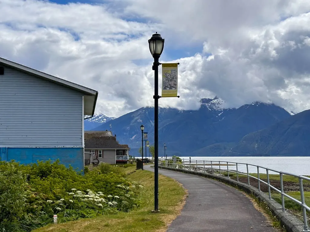
Gingolx
The village of Gingolx is located at the end of the Nisaga’a Highway. It used to be called Kincolith, an anglicized version of the Nisga’a name.
The village sits at the mouth of the Nass River on Portland Inlet. Gingolx is also known as the seafood capital of the Nass, thanks to its great fishing. But the Nisga’a call it place of skulls or place of scalps since the Nisga’a warned invaders by displaying the skulls of their enemies on trees and cliffs nearby. Locals told us that these invaders were often Haida people from Haida Gwaii on the other side of the Hecate Strait.
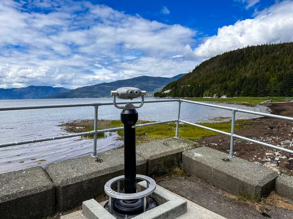
There was no road to Gingolx until 2002 – the only access was by boat. It is less isolated today, but it remains a sleepy place. Walk along the waterfront seawall to enjoy the incredible ocean and mountain views. And keep an eye out for eagles – there are dozens of them here! If you are into fishing, this is THE spot.


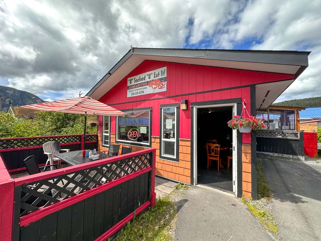
“U” Seefood “U” Eat It!
There is only one real restaurant in the Nass Valley: “U” Seefood “U” Eat It! in Gingolx. This small family-run restaurant cooks up fish and chips fresh to order. They also have lots of other seafood dishes including crab poutine and seafood chowder. We enjoyed eating on their sunny patio.

Where to Stay in the Nass Valley
Many people make a day trip to the Nass Valley from Terrace, since it has more hotel choices. If you are looking to stay overnight in Terrace, The Lodge at Skeena Landing has a gorgeous forest setting, big rooms, and an on-site cafe. Check prices.
However, I recommend staying at least one night in the Nass Valley. That way you can spend more time exploring and less time driving. There are only a few places to stay in Nisga’a Territory. Be sure to book in advance.
Hotels and B&Bs in the Nass Valley
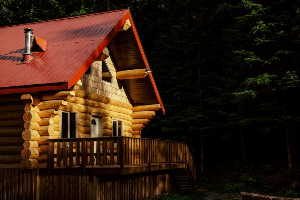
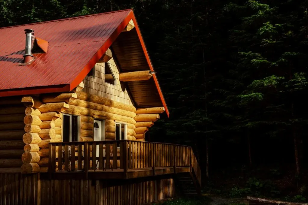
Vetter Falls Lodge: Located just outside of Gitlax’taamiks (New Aiyansh), the Vetter Falls Lodge has a beautiful setting near the banks of the Tseax River. The rustic log lodge includes breakfast and you can also use their kitchen to prepare your own lunch and dinner. Check prices.
Nass Valley Bed and Breakfast: Nestled into the forest near Gitlax’taamiks (New Aiyansh), the cedar post and beam Nass Valley B&B has rooms with vaulted ceilings and includes breakfast. Guests rave about how friendly the host is. Check prices.
Lavinia’s Bed and Breakfast: This small Nisga’a-run B&B is near the ocean in Gingolx. Reviewers speak highly of the fresh fish dinners. Call (250) 326-4335 for booking and more info.
Gingolx Lodge: Run by the village of Gingolx, the Gingolx Lodge has motel-style accommodations, but they also offer meals. Check prices.
Camping in the Nass Valley
Vetter Creek Campground: Centrally located near the T-junction on Highway 113, the Vetter Creek Campground is part of Nisga’a Memorial Lava Beds Provincial Park. The basic campground has 16 first-come, first-serve sites, outhouses and a water pump. I stayed here for two nights during my trip and it was a great place to base ourselves to see the valley. The only downside – it’s buggy in June and July. More info.
Dragon Lake Campground: You’ll have to drive a bit out of the way to get to the free 12-site campground on Dragon Lake. It’s a 15-minute drive from Gitlax’taamiks (new Aiyansh) down the sometimes bumpy Nass Valley Forest Service Road. More info.
Grizzly Den RV Park: The gas bar in Laxgalts’ap has an RV park in a grassy field near the Nisga’a Museum. They have water, sewer, and power hook-ups. More info.
Tips for Visiting the Nass Valley
The Nass Valley is definitely off-the-beaten-path and has few services, so you need to plan ahead. Here are my top tips for visiting the Nass Valley.
- Respect Indigenous culture and heritage. Do not enter closed areas. Always ask before taking photos, especially of people and cultural objects. Remember that you are a guest on this land.
- Chat with the locals. They are really friendly and often want to share their stories.
- Make hotel and B&B reservations in advance. For camping, you can just turn-up.
- Many businesses are not open consistently. Plan ahead by bringing your own supplies. But if a shop or restaurant is open, please visit it to support the local economy.
- Confirm opening hours for the Museum, hot springs, and Tseax Cone guided hike. Try to plan your trip for a time when you can visit these signature attractions.
- Pack warm and waterproof clothing. It gets chilly and it can rain a lot.
- Bring bug-spray if you camping or visiting the hot springs, especially in June and July.

So that’s everything you need to know to plan a trip to Nisga’a Territory in the Nass Valley. I really encourage you to go – it’s such a unique and special place.
READ NEXT:
- 20+ Things to do in Prince Rupert, BC
- Things to Do in Haida Gwaii
- Inside Passage Ferry from Port Hardy to Prince Rupert, BC
- Where to Experience Indigenous Tourism in Canada


- Best Sun Hoodies for Hiking - June 3, 2026
- Lower Stein Valley Trail Hiking and Backpacking Guide - May 27, 2026
- The Best Things to Do in Vernon, BC - May 21, 2026
Liza Levchuk
Friday 14th of February 2025
Thank you for your lovely overview of the Nass Valley. During the mid 80s, I lived for two years in the original cabin at what became the Vetter Falls Lodge, named "Lilyhome", after Lily Vetter, and met one of her contemporaries. It was a remarkable experience. The beauty of the Nass Valley and the warmth of the Nisga'a people are a treasured memory.