A few years ago, I heard there were dinosaur fossils somewhere in Northern BC. And then someone showed me a video of Kinuseo Falls and said it was near Tumbler Ridge, “You know, that town with the dinosaurs?” I didn’t know, so I did some research. And it turns out there are tons of cool things to do in Tumbler Ridge.
I finally got to go to Tumbler Ridge last summer on a big road trip through Central and Northern BC. I got to see the dinosaur fossils and dinosaur footprints, of course. And I took an unforgettable jet boat ride to Tumbler Ridge. But I also discovered that the area is part of the Tumbler Ridge UNESCO Global Geopark.
It’s one of only five UNESCO Geoparks in Canada and the only one in Western North America. The park protects all kinds of unique geological formations, so the area has incredible hiking. My favourite was Shipyard Titanic, where long ridges of rock look like shipwrecks embedded in a mountainside. But I also loved some of the other waterfall hikes.
Tumbler Ridge is a unique and worthwhile off-the-beaten-path destination in Northern BC that combines hiking and outdoor adventures with dinosaur tracks and fossils.
I’ve put together a complete guide to the best things to do in Tumbler Ridge for you. It includes:
- Tumbler Ridge at a glance: a quick overview
- A map of things to do in Tumbler Ridge that shows all the places I mention in this post.
- What is the Tumbler Ridge UNESCO Global Geopark? How is it different than a provincial park?
- Best things to do in Tumbler Ridge: Hikes, waterfalls, dinosaurs, and more.
- Where to eat in Tumbler Ridge: The restaurants and cafes I recommend.
- Where to stay in Tumbler Ridge: My picks for the best hotels.
- Tumbler Ridge travel tips: How to get there? How long to spend? Best time to go? And lots more.
This is a sensitive wilderness area. Learn how to Leave No Trace to keep the wilderness wild. Make sure you are prepared by bringing the 10 Essentials. Get ready for adventure with this checklist of things to do before every hike.
Hey there: Thanks so much to Northern BC Tourism for hosting me during my trip to Tumbler Ridge. All opinions in this post are my own. Some of the links in this post are affiliate links, which means I earn a small commission at no cost to you. Thanks for your support – Taryn
Table of Contents
Tumbler Ridge at a Glance
Best for: Hiking, waterfalls, dinosaurs, fossils, geology, and outdoor adventures
How many days: 1 to 2 days for the highlights, 3 to 4 days for serious hikers
Best time to visit: June to September for hiking and most attractions
Location: Northeastern BC
Nearest airports: Fort St John and Prince George
Getting around: A vehicle is essential for exploring.
Best dinosaur experience: Guided dinosaur trackway tour
Best waterfall: Kinuseo Falls
Best hike: Shipyard Titanic
Map of Things to Do in Tumbler Ridge
To help you plan your trip and find your way around, I created a custom Google map of Tumbler Ridge for you. It includes every place I mention in this post.

What is the Tumbler Ridge UNESCO Global Geopark?
The Tumbler Ridge UNESCO Global Geopark covers over 8,700 square kilometres on the eastern slopes of the Northern Rocky Mountains. Founded in 2014, the park focuses on education, sustainable development and connecting people with the area’s natural history.
The park includes 34 accessible geosites that include waterfalls, mountains, canyons, and rock formations. However, the area is most famous for dinosaur trackways and fossils. It contains the only accessible dinosaur trackways in British Columbia and rare tyrannosaurus footprints. The rocks in the park date back over 700 million years.
Unlike a provincial park or national park, a UNESCO Global Geopark isn’t a strictly protected nature reserve. Instead, it is a way for locals and visitors to connect with the land. Geology is important to Tumbler Ridge, but not just as a way to attract tourists. Tumbler Ridge is a mining town, and the Geopark coexists with surrounding coal mines, forestry operations, and wind farms.

Best Things to Do in Tumbler Ridge, BC
Visit Kinuseo Falls
Kinuseo Falls is one of the most spectacular waterfalls in British Columbia. But since it is hidden away in Monkman Provincial Park in Northern BC, not that many people have heard of it.
The falls are 70 metres tall, making them even taller than Niagara Falls. Kinuseo Falls sits on the Murray River, which originates high in the Northern Rocky Mountains. Huge volumes of water come over the falls during the spring and early summer when the high mountain snows are melting.
There are two ways to see the falls: You can take a jet boat to the base, or you can drive to the top. I’ve got details on both below.

Jet boat tour to Kinuseo Falls
Best for: Seeing the base of the falls, photography, a cool jet boat ride
Time Needed: 4 hours
Distance from downtown Tumbler Ridge: 5-minute drive to the boat launch
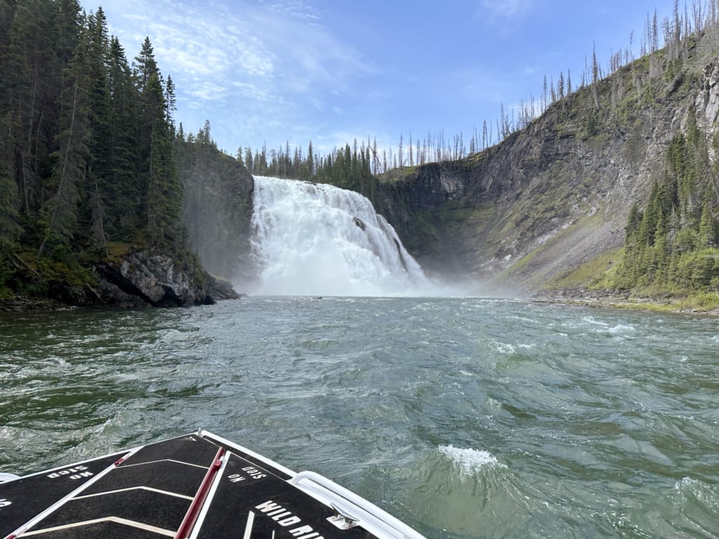
By far the coolest thing I did in Tumbler Ridge was taking a jet boat to Kinuseo Falls with Randy from Wild River Adventure Tours. He took us on a four-hour tour up the Murray River.
We launched just outside of Tumbler Ridge off of Highway 29, and then jetted upstream. I was blown away by the speed of the boat (about 60 km/h) and that it can run in really shallow water (under 1 foot!) Randy knows the river well and piloted us over gravel bars, around bends, and past cliffs. In a few places we paused to look at rock formations, small waterfalls, and mountain views.
Before I knew it, we went around a corner, and there it was: Kinuseo Falls! Randy hadn’t warned us at all! He told us later that, from experience, he knew that guests liked to be surprised. He was right! Randy took us up close to the falls, and the spray was insane. Then we secured the boat to the bank and walked out on a little island right in front of the falls to get some photos.
Next, Randy took us a few minutes back upstream to a private camping area he has licensed from the provincial park. He made us great beef brisket sandwiches for lunch on his camp stove and told us stories about the area. Randy has been hiking, hunting, ATVing and boating in the area for decades, so he is a go-to guy for adventures in Tumbler Ridge through his Wild River Adventure Tours business.
After lunch, Randy took us back to the falls for one last view. But this time we knew it was coming when we rounded the corner! Then we sped back downstream to the boat launch, going even faster with the current.


Drive to Kinuseo Falls Viewpoint and Trails
Best for: Seeing the top of the falls, hiking to viewpoints
Time Needed: 1 to 3 hours
Distance from downtown Tumbler Ridge: 1.25-hour drive, 50 km of which is on a gravel road
Since I went to Kinuseo Falls by jet boat, I haven’t actually done the drive to the falls. But I did research the driving route when I was deciding which option to take, so I’ve got all the info you need.
Kinuseo Falls is located in Monkman Provincial Park, which you can access via 14 km of driving on Highway 52E and then 50 km on the gravel Murray River Forest Service Road. The drive takes 1.25 hours and is usually suitable for standard 2WD vehicles, but it can be bumpy and muddy, so an AWD or 4WD vehicle is recommended. There is a parking lot just above the falls.
From the parking area, it’s a short and easy 250 m walk along the river to the viewing platform. Unfortunately, the viewing platform is closed as of summer 2026 while BC Parks builds a new one. BC Parks plans to open the new platform for the 2027 season, but they haven’t announced an official opening date yet.
With the viewing platform closed, you can still hike to see the falls. There are four other viewpoints:
- Upper Viewpoint: 0.25 km from the parking lot. View of the top of the falls from above.
- Leake Viewpoint: 1.5 km from the parking lot. View of the falls from slightly around the corner, above river level.
- Riverside Viewpoint: 2 km from the parking lot. View of the falls from slightly around the corner from river level.
- Downstream Viewpoint: 2 km from the parking lot. View of the falls from further around the corner from above river level.

Learn About Dinosaurs and Fossils
In 2000, two boys from Tumbler Ridge discovered dinosaur footprints while playing in Flatbed Creek. It was the first of many fossil finds in the area. Since then, researchers have discovered several new dinosaur species and found fossils that span 500 million years. Here are the best places to explore Tumbler Ridge’s dinosaurs and fossils.
Visit the Tumbler Ridge Museum
Best for: Understanding the dinosaurs and geology before exploring the Geopark
Time needed: 1 to 1.5 hours
Distance from downtown Tumbler Ridge: 5 minute-drive or 20-minute walk
The Tumbler Ridge Museum is the best place to start your trip to Tumbler Ridge. Housed in an old elementary school just up the hill from the town centre, the museum has transformed the old gym into a huge gallery with dinosaur bones, dinosaur tracks and other fossils.
Exhibits explain the history of fossil exploration in the Tumbler Ridge area, and there are tons of fossils on display. You will learn about the three main types of dinosaurs found in Tumbler Ridge: the armoured plant-eating Ankylosaurus, carnivorous bipeds including tyrannosaurus, and duck-billed herbivores known as ornithopods.
The museum also has fossils from ancient marine animals, Ice Age mammoth tusks, and more. I recommend visiting the museum first to get a good background for the rest of your trip.

Take a Guided Dinosaur Trackway Tour
Best for: Seeing dinosaur trackways
Time Needed: 2 hours
Distance from downtown Tumbler Ridge: 5-minute drive
You can visit the Flatbed Creek dinosaur tracks on your own, but I highly recommend taking a Guided Dinosaur Trackway Tour. There are tours at 10 am and 2 pm every day in the summer. You can call the museum to reserve a spot (max number of guests is 10). If they have room, they also accept walk-ins up to 15 minutes before departure.
Tours meet at the Tumbler Ridge Museum and then head to the Flatbed Pools trailhead just outside of Tumbler Ridge. You’ll follow your guide on a 2 km round-trip hike to the banks of Flatbed Creek. The trail drops about 120 metres in total, so it is steep in places. However, it’s not far, and the guides go at the pace of the slowest person with lots of breaks.
On my tour, our guides were two high school students guiding tours as their summer job. It felt fitting since the original dinosaur tracks in Tumbler Ridge were discovered by boys just a few years younger than them!
The guides did a great job of explaining the dinosaur tracks and the three different types of dinosaurs whose footprints you can see. They poured water into the tracks to make them easier to see and even brought little plastic versions of each dinosaur so we could visualize what they would have looked like.
Honestly, I think it would be tough to even find the tracks without a guide since if you don’t know what you’re looking for, the tracks just look like divots in the rock. I highly recommend the tour!


Learn about the Geopark at the Tumbler Ridge Community Forest GeoCentre
Best for: Learning about the climate, ecology, and geology of the Geopark
Time Needed: 20 to 30 minutes
Distance from downtown Tumbler Ridge: None – it’s downtown
The Tumbler Ridge Community Forest GeoCentre opened in spring 2026. The small building has interactive displays that teach you about the region’s geology, climate, and ecology. The exhibits are housed in a series of drawers, inviting you to open each in sequence to tell the story of the region.
Visiting the GeoCentre is a great way to get an overview of the Geopark and the region as a whole. Heads up: Check their opening hours. We found out the hard way that they often aren’t open on weekends.

Hit the Hiking Trails
Some of the trails are located close to Tumbler Ridge and have easy paved access. But most are in remote areas with a big network of active mining roads. If you’re not confident navigating on your own, I recommend using a guide. I went with Jocelyn and Sara from Peak Wyld. They know the area well and can share lots of cool info about the rocks and plants.
I also recommend heading to the Visitor Centre before heading out on any of the hikes. It’s located in downtown Tumbler Ridge in a log cabin-style building. It has free maps and brochures detailing all the hikes and geosites you can visit. The staff can help you pick a hike and give you advice about trail conditions and driving conditions on the access roads.

Flatbed Falls
Best for: Waterfall views, close to town hike
Time Needed: 45 minutes to 1.5 hours
Difficulty: Easy
Distance: 1.5 km round-trip
Elevation Gain: 65 m
Distance from downtown Tumbler Ridge: 5-minute drive
Flatbed Falls is a short hike near Tumbler Ridge that leads down the bank to a small waterfall on Flatbed Creek. It leaves from the same trailhead as the guided Trackway Tours, so it’s a good hike to do after the tour.
The trail heads downhill through the forest. As it starts to level out, it skirts a marshy area with a few ponds and passes a log picnic shelter that locals use for education events. Continue along the trail to the river’s edge.
The 4-metre-tall falls tumble down across a broad rock shelf that stretches the width of the creek. You can walk out along the shelf to the edge of the falls. Apparently locals swim in the pool beneath the falls, but it was too cold for me!


Quality Falls
Best for: Waterfall views, beautiful forest walk
Time Needed: 1 to 2 hours
Difficulty: Easy
Distance: 2.5 km round-trip
Elevation Gain: 75 m
Distance from downtown Tumbler Ridge: 10-minute drive
If you’re looking for a short hike near Tumbler Ridge, Quality Falls is a high-quality option. (Sorry, couldn’t resist!) The trail passes through beautiful spruce forest. It’s also a great place to watch for songbirds and look for wildflowers.The trail reaches the top of the canyon where there is a viewpoint and picnic area.
But it’s worth following the steep trail as it switchbacks down to the base of the falls. You can walk up the creek to the base of the falls. On my mid-July visit, the water level was fairly low, so we could mostly hop across on rocks. However, some sections are slippery, so I did end up with wet feet. Next time, I would just take my shoes off entirely!
The falls are 7 meters tall and drop over 95 million year old sandstone. You can also watch for American dippers nesting in the crevices in the canyon walls.


Shipyard Titanic
Best for: Rock formations, views
Time Needed: 2 to 3 hours
Difficulty: Moderate
Distance: 3 km round-trip
Elevation Gain: 170 m
Distance from downtown Tumbler Ridge: 40-minute drive, 18 km of which is on gravel roads
Shipyard Titanic is the signature hike in Tumbler Ridge. If you are going to do just one hike in the area, I recommend this one!
It climbs up the slopes of Mount Babcock to several unique rock formations. Thanks to millennia of erosion, the rocks are arranged into long ridges that stick out of the surrounding landscape. Locals thought they looked like ships emerging from the slopes, so they gave them names: “The Armada”, “The Bismarck”, and “The Titanic”.
The trail works its way uphill through forest, talus, fields, and patches of subalpine meadow towards the rock formations. You can walk out on top of the Bismarck and the Titanic for spectacular views of the rocks as well as the surrounding mountains and mining infrastructure. Our guides told us that sometimes you can spot mountain goats on this trail!
The Shipyard Titanic Trail is located in the Core Lodge area south of Tumbler Ridge. To get there, you drive 14 km along Highway 52E and then onto a series of gravel mine access roads for 19 km: Quintette Mine Road, Core Lodge Road, and then S Core Lodge Road. The first two are smooth gravel but the last 3 km on S Core Lodge Road is bumpier and a bit steeper. I recommend AWD or 4WD for S Core Lodge Road.


Boulder Gardens
Best for: Rock formations, a tranquil tarn
Time Needed: 1 to 3 hours
Difficulty: Easy to Moderate
Distance: 2 km round trip or 4 km loop
Elevation Gain: 60 to 150 m
Distance from downtown Tumbler Ridge: 35-minute drive, 16 km of which is on gravel roads
The Boulder Gardens Trail is located just down the hill from Shipyard Titanic on S Core Lodge Road, so it makes sense to do both hikes on the same day.
The trail makes a loop on the slopes of Mount Babcock through a jumble of talus and rock pinnacles. The second half of the loop is a little rougher with more scrambling. We opted to just do the first half of the loop as an out-and-back to Boulder Tarn so we could save time to do Babcock Falls (details on that one below). That way we fit Shipyard Titanic, Boulder Gardens, and Babcock Falls into one day of hiking!
The trail follows old roads through the forest. Be sure to take the side trails to the right to Chimney Rock and Lichen Towers. These rock pinnacles jut up from the chaotic pile of boulders. On my visit, we saw rock climbers scaling them!
Continue through the trees to the tranquil turquoise waters of Boulder Tarn tucked into the bottom of a rock slope. This was my turn-around point, but if you continue on, you’ll pass more rock towers, giant boulders, climb through a crack, and see a cave.


Babcock Falls
Best for: Waterfall views, forest walk
Time Needed: 45 mins to 1.5 hours
Difficulty: Easy
Distance: 2 km round-trip
Elevation Gain: 50 m
Distance from downtown Tumbler Ridge: 30-minute drive, 17 km of which is on gravel roads
This short trail leads through the forest and wet subalpine meadows to Babcock Falls. Watch for flowers along the way.
You can see the falls from a viewpoint at the top of the bank, but it is worth following the short and steep trail down to the base. You can scramble along the bank to get almost underneath the waterfall. Look for fossilized logs in the rocks in this section.
Babcock Falls are only 8 meters tall, but they are still spectacular as they tumble over layers of sandstone. We hike to a few different waterfalls around Tumbler Ridge, and this one was my favourite.
The Babcock Falls trailhead is located on Core Lodge Road a few minutes past the turnoff to S Core Lodge Road (where you’ll find Shipyard Titanic and Boulder Gardens). It’s a much smoother road than S Core Lodge Road, so it is suitable for 2WD vehicles.


More Hikes in Tumbler Ridge
I spent three days in Tumbler Ridge, and honestly, I wished I had budgeted a few more days so I could squeeze in more hiking. Here are a few more hikes that are at the top of my list for a return visit:
- The Stone Corral: A short hike near the top of Kinuseo Falls to ponds and limestone cliffs.
- Bergeron Falls: A challenging loop hike to one of the highest waterfalls in the area.
- Bootski Lake: A remote alpine lake with great views.
- Monkman Cascades: A multi-day backpacking trip to waterfalls and lakes in Monkman Provincial Park.
Slow Down at Gwillim Lake and Bullmoose Marshes
Gwillim Lake
Best for: Beach, paddling, camping, views
Time Needed: 1 to 3 hours
Distance from downtown Tumbler Ridge: 30-minute drive
Road access: Paved Highway 29.
Gwillim Lake Provincial Park is just off Highway 29 in between Tumbler Ridge and Chetwynd. It has a huge lake, a campground, a beach, and a boat launch, all with great mountain views. If it was located a few hundred kilometres further south, it would be insanely busy. But this is Northern BC, so it isn’t that crowded, even on weekends.
It’s a great place to go paddling or fishing. Or go for a swim. Northerners think the water is great, but those from warmer climates will find it a little chilly.
Don’t miss the viewpoint near the park entrance. It has great views of the Northern Rocky Mountains to the south.


Bullmoose Marshes
Best for: Easy walk, bird watching
Time Needed: 30 to 90 minutes
Distance from downtown Tumbler Ridge: 20-minute drive
Road access: Paved Highway 29.
I’ve become a bit of a birder in the last few years, so I knew I had to check out Bullmoose Marshes just north of Tumbler Ridge. (It’s also called Bull Moose Flats on some maps.) From the gravel parking area just off the highway, you can follow two short trails to viewpoints of the marshes.
The 0.5 km round-trip Sora Trail takes you along a boardwalk and out to a floating viewing platform. The longer Bittern Trail is 1.3 km round trip and follows the edge of the marsh. It passes several benches and viewing areas beside ponds and side channels of Bullmoose Creek.
There are interpretive signs explaining which birds you can spot – we saw so many species of ducks, some of which had ducklings! Morning and evening are the best times to come for maximum bird activity. But bring bug spray!


Best Places to Eat in Tumbler Ridge
Tumbler Ridge is a small town and very remote, so it doesn’t have very many restaurants. That being said, everyone has to eat, so the town has a few places that do it well. Here are a few places I tried and recommend.
Twisted Seasons Bistro
Best for: Home-style cooking
Twisted Seasons Bistro is an informal counter service cafe with a great patio. We loved it so much we ate there twice! While it is mostly a lunch spot, they are open for early dinner as well. Both times we visited, Wendy was running the whole operation on her own, but she was still able to get our food really quickly. The bacon grilled cheese was amazing with a side of housemade soup.

Kinuseo Cafe
Best for: Diner-style favourites, Filipino food
We had lunch at Kinuseo Cafe and I had a great quesadilla while my friend enjoyed her clubhouse sandwich. Their extensive menu includes diner-style breakfast, pizza, burgers, sandwiches, and entrees like steak. Locals told us they have great Filipino food too!

FreshMart Grocery Store
Best for: Pre-made sandwiches, hiking snacks
Tumbler Ridge has only one grocery store, FreshMart. It’s not huge, but it was surprisingly well stocked. Unless you have specific dietary requirements, you don’t need to stock up on groceries before arriving in town. If you’re staying at a place with a kitchen, it’s easy to shop here and cook for yourself. And even if you aren’t, they have a good selection of pre-made sandwiches, baked goods, and snacks that are great to bring hiking.
Where to Stay in Tumbler Ridge
Tumbler Ridge doesn’t have a lot of accommodation options. Here are two hotels I recommend, plus some options for camping.
Trend Mountain Hotel
I stayed at the Trend Mountain Hotel during my visit to Tumbler Ridge. The town has only a few hotels, but this one is by far the nicest. It is a few minutes’ walk from the town centre. Our room was pretty big, and it had a tiny kitchenette, which was helpful for putting together some DIY hiking lunches.
I really appreciated that the hotel has coin-operated guest laundry. It was so helpful since we were out hiking every day. They also have a hot tub that guests can book by the hour. It was lovely to have it to ourselves.

Tumbler Ridge Inn
The motel-style Tumbler Ridge Inn is right across the street from Tumbler Ridge’s town centre and is priced a bit lower than Trend Mountain, so it’s a good bet if you’re on a budget. From the reviews, it sounds like it is clean and quiet, even though it is older. It also has the excellent Kinuseo Cafe on site.
Camping
There are a few options for camping in Tumbler Ridge and the surrounding area:
- Monkman RV Park: A full-service RV park on the edge of town.
- Tumbler Ridge Golf Course Campground: Eight RV sites with electricity but no water in the golf course parking lot.
- Lions Flatbed Creek Campground: Great campground on the banks of Flatbed Creek just outside Tumbler Ridge with tent and RV sites, flush toilets, and coin-op showers.
- Gwillim Lake Provincial Park: Provincial park campground with pit toilets and a water pump on a beautiful lake about 30 minutes north of Tumbler Ridge on Highway 29.
- Monkman Provincial Park: Provincial park campground near Kinuseo Falls with pit toilets and a water pump. Located 1.25 hours south of Tumbler Ridge via gravel roads.
Travel Tips for Visiting Tumbler Ridge
How Many Days Should You Spend in Tumbler Ridge?
I spent three days in Tumbler Ridge, and it was the perfect amount of time to see the highlights and go on a few hikes. In retrospect, I would have liked to have spent at least one more day there to do more hikes.
I think that most visitors should spend 1 to 3 days in Tumbler Ridge. Here’s how I’d plan a Tumbler Ridge itinerary:
- Day 1: Tumbler Ridge Museum, guided trackway tour, and a short hike like Flatbed Falls or Quality Falls
- Day 2: Kinuseo Falls
- Day 3: Core Lodge hikes (Shipyard Titanic, Boulder Gardens, and Babcock Falls)

When is the Best Time to Visit Tumbler Ridge?
The best time to visit Tumbler Ridge is in July and August. That’s when you will have the best weather for hiking, and the museum, GeoCentre and visitor centre have the longest opening hours.
How Do You Get to Tumbler Ridge?
Tumbler Ridge is in a remote part of northeastern BC, but it’s actually pretty close to the larger communities of Dawson Creek and Fort St John. Most people visit Tumbler Ridge as part of a larger road trip through Northern BC starting in Prince George or Prince Rupert.
Tumbler Ridge sits at the intersection of Highways 29 and 52, accessed off Highway 97. Highway 97 is the main north-south route through British Columbia and becomes the Alaska Highway just north of Tumbler Ridge.
If you’re using a GPS to navigate to Tumbler Ridge, be sure to stick to major highways – avoid “shortcuts” on gravel forest service roads that may be in rough condition.
Here are some rough driving times between Tumbler Ridge and major Western Canada destinations:
- Prince George, BC to Tumbler Ridge: 4.25 hours
- Prince Rupert, BC to Tumbler Ridge: 12 hours
- Dawson Creek, BC to Tumbler Ridge: 1.25 hours
- Fort St John, BC to Tumbler Ridge: 2 hours
- Grande Prairie, AB to Tumbler Ridge: 2.5 hours
While Tumbler Ridge doesn’t have scheduled flights, you can fly to nearby airports and then rent a car. Prince George has the most flight and rental car options. Fort St John, Grande Prairie, and Dawson Creek all have smaller airports with a few flight options.
There is no bus service to Tumbler Ridge.

How Do You Get Around Tumbler Ridge?
Tumbler Ridge’s town center is very walkable, and since it is a small place, everything is clustered quite close together. However, if you are heading out of town, you’ll need a car.
You can access a few attractions via paved roads, but you will need to travel on gravel roads to trailheads. I’ve got info on road access type for each of the attractions I’ve listed above.
Most of these grael roads are bumpy but are fine for all vehicles if you go slow. If possible, I recommend all-wheel-drive or four-wheel-drive vehicles with a bit of clearance (e.g. SUVs or trucks).
Most of the roads around Tumbler Ridge are used by industrial traffic for mining, forestry, and wind farms. Watch for trucks and pull over to let faster vehicles pass you.
Ask at the Visitor Centre about current road conditions before you go.
What is the Weather Like in Tumbler Ridge?
Tumbler Ridge is in Northern BC, so it has mild weather in summer. You can expect highs of 17°C to 22°C (63°F to 71°F) and lows of 7°C to 10°C (45°F to 50°F) in July and August. And since you’re up north, you can expect long daylight hours, especially in June and July.
It’s a relatively dry area, so it is usually sunny, and it doesn’t get that much rain. However, the summer months are the rainiest, with about 7 days each month getting some rain.

Cell Service in Tumbler Ridge
There is good cell service in the town of Tumbler Ridge, but you will have no service on most of the drive to get there or on the surrounding hiking trails.
If you have a Canadian cell phone, you’ll get the best service if you are with Telus or Bell (or one of the providers that uses their towers like Koodo, Public Mobile, and Virgin). You will likely have bad signal or no signal if you are with Rogers or one of their partners, including Fido, Chatr, or Videotron.
For international visitors, you’ll be roaming to look for the best signal, which is usually Telus or Bell. If you buy an eSIM, they typically connect to the strongest local signal.
Make sure you look up Google Maps directions in advance and download offline hiking maps from apps like All Trails or Gaia GPS before you leave town.
Hiking Safety in Tumbler Ridge
Tumbler Ridge is a remote place, so you need to be safe and self-sufficient when you hike. If you aren’t confident going alone, I recommend going with a guide. I did a few hikes with Jocelyn and Sara from Peak Wyld. They know the Tumbler Ridge trails and access roads well and can make recommendations about the best hike for you.
In general, here are a few safety tips to keep in mind:
- Carry the 10 essentials: These are key gear items like food, water, and a first aid kit that will help you out in an emergency.
- Leave a trip plan: Tell someone where you are going and when you expect to be back.
- Be bear aware: Carry bear spray, hike in a group, and make noise.
- Don’t rely on cell service: It drops off outside of town. Download offline maps and directions in advance.
- Use a navigation app: I recommend Gaia GPS or AllTrails for hiking and backroad navigation.
- Don’t touch or remove fossils: Take photos and coordinates, then report them to the Tumbler Ridge Museum staff.

Respecting the Tumbler Ridge Community
In February 2026, Tumbler Ridge experienced a devastating tragedy when a mass shooter at Tumbler Ridge Secondary School took the lives of eight people. The Tumbler Ridge community is continuing to grieve and recover.
If you’re visiting Tumbler Ridge, please be mindful that this is a small community where many people have been personally affected. On my visit, I saw signs on local businesses requesting that visitors do not discuss the shooting. Please respect those requests.
Instead, come prepared to experience Tumbler Ridge for what it has to offer: gorgeous waterfalls, great hiking, dinosaur tracks, fossils, and the sprawling UNESCO Global Geopark.
Final Thoughts
Tumbler Ridge is a place that had been on my bucket list for a few years. Once I heard about the dinosaur fossils and Kinuseo Falls, I knew I had to go. And then once I was planning my trip, I saw photos of Shipyard Titanic and knew that had to be on my list too!
Now that I’ve been, I’m kind of kicking myself that I didn’t spend at least one more day in Tumbler Ridge to do more hiking; I would have loved to squeeze in one of the alpine hikes like Bootski Lake. And now I’m seriously thinking about going back to do a backpacking trip to Monkman Cascades!
If you’re planning a trip to Northern BC, here’s what you should read next: