
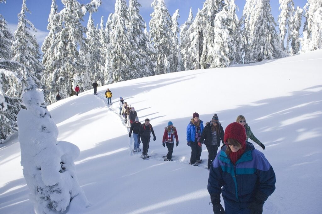

I know it’s a bold statement, but I think Manning Park is the best place to snowshoe in southwestern BC. Here’s why snowshoeing in Manning Park is so awesome:
- Easy drive from Greater Vancouver on a plowed and sanded highway.
- Usually low avalanche risk.
- Better weather and fluffier snow than the coast.
- No stupidly steep climbs. Gorgeous mountain views.
- TONS of trails ranging from super flat beginner routes to all-day epics in the backcountry that climb mountains.
I mean, what else do you need? In this guide I’ll give you all the details you need to choose the right trail for snowshoeing in Manning Park, plus tips to keep you safe on the trail.
This guide to snowshoeing in Manning Park includes:
- Quick reference guide: An easy overview of the stats for all the trails
- Snowshoeing safety: key info to help get you prepared to snowshoe in Vancouver
- Where to rent snowshoes in Manning Park including which shops have the best price
- Snowshoe trails in Manning Park: details for 9 trails
- No-go trails: summer trails that aren’t safe for snowshoeing
Psst! Looking for even more places to snowshoe in British Columbia? Check out these Vancouver-area snowshoe guides:
- Snowshoeing in Vancouver
- Snowshoeing in the Fraser Valley
- Snowshoeing in Whistler
- Snowshoeing in Squamish
Hey there: Some of the links in this post are affiliate links, which means I earn a small commission at no extra cost to you if you make a purchase. Thanks for supporting my website! -Taryn
Snowshoeing in Manning Park Quick Reference Guide
| Trail | Rating | Time | Cost |
|---|---|---|---|
| Skagit River Trail | Easy | 3-4 hours | FREE |
| Mount Kelly | Challenging | 3.5-5 hours | FREE |
| Cambie Creek Loop | Easy | 1.5-2 hours | FREE |
| Fat Dog Trail | Challenging | 6-8 hours | FREE |
| Manning Park Lodge Trails | Super Easy | 1-1.5 hours | $10 |
| Canyon Nature Trail | Easy | 1-1.5 hours | FREE |
| Windy Joe Mountain | Challenging | 5-7 hours | FREE |
| Lightning Lakes Loop | Moderate | 3-4 hours | FREE |
| Poland Lake | Challenging | 6-8 hours | FREE |
But First… Be Prepared
- Make a trip plan: While these trails may be steps from busy ski areas, they access serious wilderness. Tell someone where you are going and when you expect to be back. Use the great trip planning tools from Adventure Smart.
- Check the weather, trail conditions, and avalanche forecast: If the weather and trail conditions don’t look good, don’t go. Use my list of the best weather apps for hiking. Check the avalanche forecast. Unless you have taken an avalanche safety course, you probably shouldn’t go out unless the forecast is rated “Low”.
- Wear winter clothing and pack the essentials: Prepare for emergencies by packing the 10 essentials. Read my recommendations for what to wear snowshoeing and tips for winter hiking and snowshoeing.
- Use safe snowshoeing techniques: Snowshoes keep you from sinking into deep snow, but they aren’t great for walking sideways or downhill – it’s easy to slip and injure yourself. Read up on snowshoeing safety and check out my guide to choosing snowshoes.) They also have crampons and other traction aids underfoot to help grip icy snow.
- Take an avalanche safety course: If you plan to stray from flat terrain, you need avalanche safety training. great FREE online beginner tutorial on Avalanche.ca. You should also take a 2.5 day AST1 course with avalanche Canada.
READ NEXT: Snowshoeing Safety: 14 Ways to Get into Trouble and How to Prevent Them
Join: Snowshoeing in Vancouver Facebook Group
Snowshoeing on the Skagit River Trail at Sumallo Grove
Note: The bridge across the river at the beginning of the trail is washed out. The river doesn’t reliably freeze over, making this trail impassable until the bridge is fixed.
Distance: Up to 9km return
Time Needed: 3-4 hours
Elevation Gain: None
Rating: Easy
The Trail: The Skagit River trail runs 15km down the banks of the… you guessed it: Skagit River. In winter Delacey camp at the 4km mark makes a good place to turn around. Along the way you’ll pass through the large old growth trees of Sumallo Grove. Be sure to take the side trail around the 2km mark to visit an old abandoned mining truck.
Since the access road is gated in the winter you’ll add an extra 0.5km each way to walk in to the summer parking lot.
Note that this trail is at a much lower elevation than the rest of the snowshoeing trails in Manning Park (only 650m) so it will not receive as much snow and may be snow-free in warmer weather.
Avalanche Danger and Hazards: Watch for open creeks and narrow snow-covered bridges along the trail. There is no immediate avalanche danger on the trail, but there are some substantial avalanche slopes up the hill from the trail. If the avalanche forecast is above low, it may not be smart to be down in this valley.
Trail Map/Guide: You can find info on the Manning Provincial Park website.
Permits/Fees: None.
Dogs: Permitted on leash.
Driving Directions: From Hope drive 30 minutes to the Sumallo Grove picnic area turn off on your right. Click here for driving directions. The gate to the parking lot is locked in the winter so you’ll have to park on the shoulder of the highway and walk in. There is space for a few cars outside the gate. Winter tires or chains are required to drive Highway 3 in winter.
Snowshoeing Mount Kelly
Distance: 7 km
Time Needed: 3.5-5 hours
Elevation Gain: 560 m
Rating: Challenging
The Trail: This trail has grown in popularity for snowshoeing in the last few years. The trail follows an old road in the lower sections and a trail up higher as it steadily gains elevation. The route is almost entirely through the forest. The summit doesn’t have a great view, but there are a few peek-a-boo views lower down on the trail. Experienced snowshoers can also explore off-trail along the ridge towards Nordheim Peak to the northwest for better views.
Avalanche Danger and Hazards: The kilometre of the trail has some moderate avalanche exposure, but since it is in the trees, the risk is usually fairly low. Use caution and check the avalanche forecast before you go. There are a few steep sections of trail where you will need to watch your step – poles or an ice axe can help. After the trail leaves the logging road, it can be hard to find in fresh snow so you will need route-finding experience. If you choose to explore the ridge towards Nordheim, you must be experienced in off-trail route finding.
Trail Map/Guide: There’s a good write-up on Best Hikes BC.
Permits/Fees: None.
Dogs: Allowed on leash.
Driving Directions: From Hope drive 45 minutes to Allison Pass Summit. Turn right through the gate into the Highway works yard. You are allowed to park here as long as you park off to the side away from any Highway works vehicles. Click here for driving directions. Winter tires or chains are required to drive Highway 3 in winter.
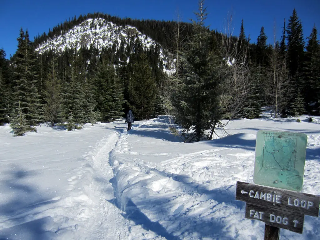
Snowshoeing Cambie Creek Loop

Distance: 2.5-5km
Time Needed: 1.-5-2 hours
Elevation Gain: Up to 100m
Rating: Easy
The Trail: There are two interconnected cross country ski loop trails along the banks of the of the Similkameen River, collectively known as the Cambie Creek Loop. The trails are relatively flat and make a great snowshoe trip for beginners. The trails are un-groomed, but be prepared to share the trail with cross country skiers – don’t walk in their ski tracks.
Avalanche Danger and Hazards: For many years one of the bridges on this trail was washed out and you couldn’t complete the loop. However, that is no longer a problem. The trail is down in the valley bottom and there are a few very steep slopes immediately uphill of the trail. Use caution and check the avalanche forecast before you go.
Trail Map/Guide: Surprisingly there is very little information online about this trail. There is a good map posted at trailhead.
Permits/Fees: None.
Dogs: Allowed on leash.
Driving Directions: From Hope drive 45 minutes to the Cambie Creek Winter Group Campsite turn off on your left. Click here for driving directions. There is a large plowed parking area. Winter tires or chains are required to drive Highway 3 in winter.
Snowshoeing the Fat Dog Trail

Distance: 15km
Time Needed: 6-8 hours
Elevation Gain: 700m
Rating: Challenging
The Trail: This trail climbs up high into the alpine and on a clear day you can get some great views. Despite all the elevation gain, the trail is on an old road so it never gets too steep. The trail is also popular with backcountry skiers so be sure to walk outside their ski tracks. The Fat Dog Trail doesn’t have a definite end point – it peters out in the high alpine meadows so turn around when ever you’ve had enough of the views.
Avalanche Danger and Hazards: The first few kilometres of the trail are down in the valley bottom and there are a few very steep slopes immediately uphill of the trail. Use caution and check the avalanche forecast before you go. The remainder of the trail is in much more mellow terrain. Be careful of cornices along the ridge at the top.
Trail Map/Guide: There’s a map and a little bit of information on All Trails.
Permits/Fees: None.
Dogs: Allowed on leash.
Driving Directions: From Hope drive 45 minutes to the Cambie Creek Winter Group Campsite turn off on your left. Click here for driving directions. There is a large plowed parking area. Winter tires or chains are required to drive Highway 3 in winter.
Lodge Area Snowshoe Trails
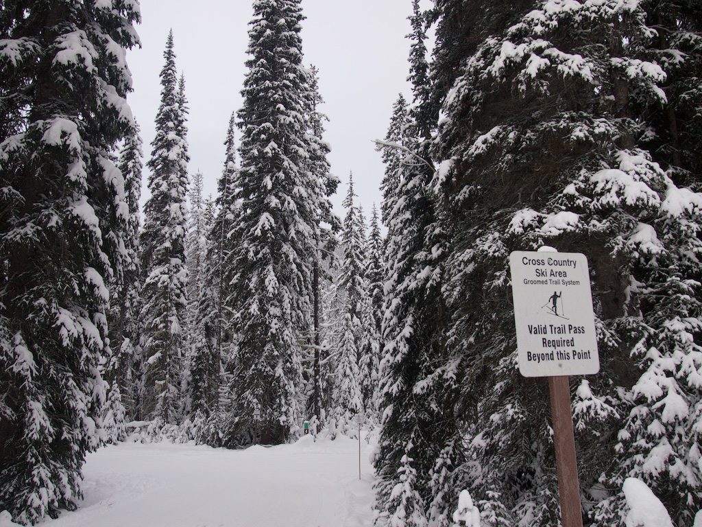

Distance: Up to 3.5km return
Time Needed: 1-1.5 hours
Elevation Gain: Up to 50m
Rating: Super easy
The Trail: Manning Park Resort maintains a small network of snowshoe trails right next to their cabins. If you stay there you can snowshoe right out your front door. The trails are flat and well marked. Various loops are possible and there’s even a small lookout.
Avalanche Danger and Hazards: None.
Trail Map/Guide: There’s info on Manning Park Resort’s website and they will also give you a map when you buy your trail pass.
Permits/Fees: You need a Manning Park Resort Snowshoe Trail pass for these trails. A day pass costs $10 and you can buy one at the Nordic Centre near the Lodge.
Dogs: Allowed on leash.
Driving Directions: From Hope drive 50 minutes to the Manning Park Lodge turn off on your right. Click here for driving directions. There is a large plowed parking area at the Lodge. Winter tires or chains are required to drive Highway 3 in winter.
Join: Snowshoeing in Vancouver Facebook Group
Snowshoeing the Canyon Nature Trail
Distance: 2km loop
Time Needed: 1-1.5 hours
Elevation Gain: 50m
Rating: Easy
The Trail: This short nature trail follows the banks of the Similkameen River as it winds through a mini-canyon. You’ll walk up one side of the river to a bridge near the Coldspring Campground, cross it and come back down the other side of the river.
Avalanche Danger and Hazards: In some areas the trail gets close to the river bank. Use caution. This trail doesn’t have winter markings so it could be difficult to follow if no one has walked there recently. However, the trail stays down in the canyon so it shouldn’t be too hard to stay on track.
Trail Map/Guide: There’s trail information and a map on the Manning Provincial Park website.
Permits/Fees: None. While this trail starts next to Manning Park Resort’s Nordic Ski Trails, which do require a paid trail pass, this trail is strictly within BC Park’s jurisdiction and is free to use.
Dogs: Allowed on leash.
Driving Directions: From Hope drive 50 minutes to the Manning Park Lodge turn off on your right. Turn down Gibson Road and follow it for a couple minutes. Immediately after crossing a bridge you’ll see the trailhead on your right. Click here for driving directions. There is a small plowed pull out on the side of the road. Winter tires or chains are required to drive Highway 3 in winter.
Snowshoeing to Windy Joe Mountain
Distance: 16km round trip
Time Needed: 5-7 hours
Elevation Gain: 500m
Rating: Challenging
The Trail: This trail climbs Windy Joe Mountain on an old road. Thankfully the grade is never too steep. At the top you can explore an old fire lookout tower, last used in the 1960s. Be sure to climb up into the loft where a sign helps you identify all the peaks you are looking at.
Distance: 16km round trip
Avalanche Danger and Hazards: The trail traverses mostly mild terrain, but there it does cross a steep slope on the first switchback so use caution in this area and check the avalanche forecast before you go.
Trail Map/Guide: There’s a good trail guide on the Manning Provincial Park website. There’s a map as well.
Permits/Fees: None.
Dogs: Allowed on leash.
Driving Directions: From Hope drive 50 minutes to the Manning Park Lodge turn off on your right. Turn down Gibson Road and follow it for a couple minutes. Immediately after crossing a bridge you’ll see the trailhead on your left. Click here for driving directions. There is a small plowed pull out on the side of the road. Winter tires or chains are required to drive Highway 3 in winter.
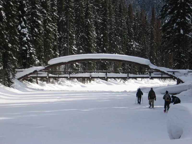
Snowshoeing the Lightning Lakes Loop
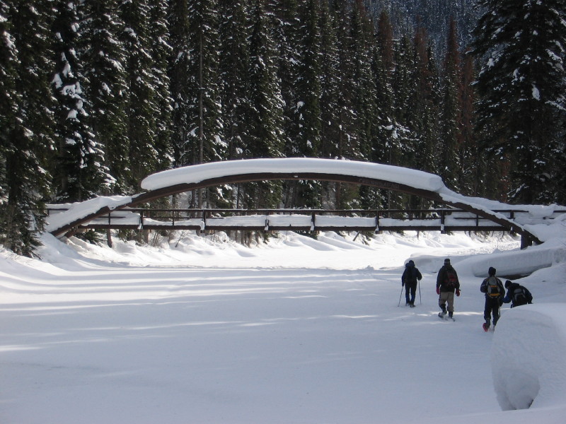
Distance: 9km
Time Needed: 3-4 hours
Elevation Gain: 50m
Rating: Moderate
The Trail: In the summer the Lightning Lakes trail is THE hike in Manning Park. So of course in winter this is THE place to go snowshoeing in Manning Park. The loop around Lightning Lake is a wonderful mellow trail, and if you want to make it even flatter, you can walk on the lake itself. The highlight is visiting the Rainbow Bridge when it’s all covered in snow.
Avalanche Danger and Hazards: There is no major avalanche danger on the trail. If the lake is sufficiently frozen you can take a shortcut on the ice across the mouth of Lone Duck Bay. Be careful and don’t try this late or early in the season. If you can’t take the shortcut across the ice, you’ll have to go around the long way on the Lone Duck Trail. The Lone Duck trail is technically a cross country ski trail in the winter. Stay well to the side of the trail and don’t walk in the ski tracks.
Trail Map/Guide: You can find trail info and a map on the Manning Provincial Park website.
Permits/Fees: None.
Dogs: Allowed on leash.
Driving Directions: From Hope drive 50 minutes to the Manning Park Lodge turn off on your right. Turn down Gibson Road and follow it for 5 minutes. Take the signed turn off to the left for the Lightning Lakes Day Use Area. Click here for driving directions. There is a large plowed parking lot at the end of the road. Winter tires or chains are required to drive Highway 3 in winter.
Snowshoeing to Poland Lake
Distance: 16km return
Time Needed: 6-8 hours
Elevation Gain: 450m
Rating: Challenging
The Trail: Poland Lake is one of the less visited areas in Manning Park in both summer and winter, despite the fact that it’s only a short drive from the lodge.
Manning Park used to offer a $10 lift ticket for snowshoers to get to the top of the lift but they cancelled that in March 2021.
The old winter route followed ski runs up to the ridge, but starting in 2022, Manning Park Resort has opened a snowshoe trail that avoids the ski runs but is much longer. You also must get a free trail ticket at Alpine Guest Services to use this route.
The trail starts at Strawberry Flats parking area and follows an old road on the north side of the Gibsons Pass Road. After about 1.5km, it leaves the road on a flagged route.
About 2.5km from the trailhead, the route crosses the Manning Park Ski area. You need to get a trail ticket at guest services here, then cross the ski area.
The next section is a big climb in the woods to the west of the Blue Chair, gaining about 300 m over the next 1.5 km. The flagged route ends on the top of the ridge about 4 km from the trailhead, where the route joins the Poland Lake Trail. Turn left and follow this trail, which is an old road, along the top of an undulating ridge all the way to pretty little Poland Lake.
Avalanche Danger and Hazards: The first part of the trail passes below avalanche slopes. Check the avalanche forecast before your trip. Use caution crossing the ski runs.
Trail Map/Guide: You can find info and a map of the winter route on the Manning Park Resort website.
Permits/Fees: Free
Dogs: Dogs are not allowed on the lift or in the ski area.
Driving Directions: Unfortunately, snowshoers are no longer allowed to park at the downhill ski area. Instead, you’ll need to park about 2.5 km earlier at Strawberry Flats. From Hope drive 50 minutes to the Manning Park Lodge turn off on your right. Turn down Gibson Road and follow it for 10 minutes to the Strawberry Flats parking area. Click here for driving directions. There is a large plowed parking lot at the end of the road. Winter tires or chains are required to drive Highway 3 in winter.
Join: Snowshoeing in Vancouver Facebook Group
No-Go Trails for Snowshoeing in Manning Park
There are a few summer hiking trails in Manning Park that may sound like a fun snowshoe adventure in winter. However, many of them have significant avalanche danger, are closed in winter, or just don’t have enough consistent snow for good snowshoeing.
- Heather Trail: The road to trailhead is actually groomed as a cross-country ski trail and snowshoeing is not allowed.
- Lightning Lakes Chain (Flash and Strike Lakes): Experienced snowshoers can continue past the end of Lightning Lake to Flash and Strike Lakes. However, there is significant overhead avalanche hazard and the trails are not well-marked.
- Frosty Mountain: This trail is very long (21 km round-trip) and it is not easy to find the trail in the winter, so only very experienced snowshoers should tackle this trail.
- Skyline II and II: These trails are difficult to find in the winter. As well, they have some very steep slopes where a slip could be fatal. The trails are also in prime avalanche start zones.
Final Thoughts
How many of these Manning Park trails have you snowshoed? Have questions about snowshoeing in Manning Park? Hit me up in the comments.
READ NEXT:
More Snowshoeing Guides:
- Snowshoeing in Vancouver
- Snowshoeing in Squamish
- Snowshoeing in Whistler
- Snowshoeing in Vancouver’s Fraser Valley
Snowshoeing and Winter Hiking Advice
- How to Choose Snowshoes: A Complete Guide
- The Best Boots For Snowshoeing
- Best Gifts for Snowshoers (20+ Ideas)
- Snowshoeing Safety: 14 Ways to Get into Trouble and How to Prevent Them
- What to Wear Winter Hiking and Snowshoeing
- 9 Tips for Winter Hiking (You Don’t Have to Freeze!)
- 100+ Snow-Free Hikes in Vancouver: Trails You Can Hike Year Round


- Things to Do on Newfoundland’s Great Northern Peninsula - July 29, 2026
- Best Sun Hoodies for Hiking - June 3, 2026
- Lower Stein Valley Trail Hiking and Backpacking Guide - May 27, 2026
Rodney Thiessen
Saturday 20th of February 2021
Just to update: You CANNOT snowshoe from Shadow Lake through to the Three Falls trail. Snowshoeing to Shadow Lake is permitted with a pass but you cannot use the groomed trail through to the Three Falls Trail (according to Park staff). To access the Three Falls trail in winter you must start at the ski hill.
Taryn Eyton
Sunday 21st of February 2021
Thanks for the update Rodney. I think that's a newer change this year as in previous years the resort didn't include Shadow Lake as part of their groomed trails. I'll update the post.
Cal Francis
Wednesday 9th of January 2019
Excellent page. I think you should add MT Kelly in Manning park to this page.
Taryn Eyton
Thursday 10th of January 2019
That's a great idea. I haven't hiked or snowshoed Mount Kelly yet but I'll put it on the list.
patrick mooney
Monday 7th of January 2019
I love everything you've shared in this article and others, I too live in the City, but my heart and soul are in the mountains and surrounded by nature. Wishing you all the best and thanks for helping others explore and find beautiful places in BC
Taryn Eyton
Monday 7th of January 2019
Thanks for your kind words Patrick. It's always so nice to hear from others who find happiness in nature.
A speck in time
Saturday 27th of January 2018
I want to try snowshoeing someday soon, and do lots of snow photography. Your post is a great resource for first timers like me. Thank you so much for putting so much details.
Valerie
Saturday 27th of January 2018
I love your blog!! I am Canadian also , raised in Vancouver area...I think I was here years ago...so beautiful. I think I found a place I need to go explore! Thanks for sharing, beautiful pictures!
VAlerie