
Note: I’ve updated my Mount Assiniboine hiking guide to include updated info for 2026.
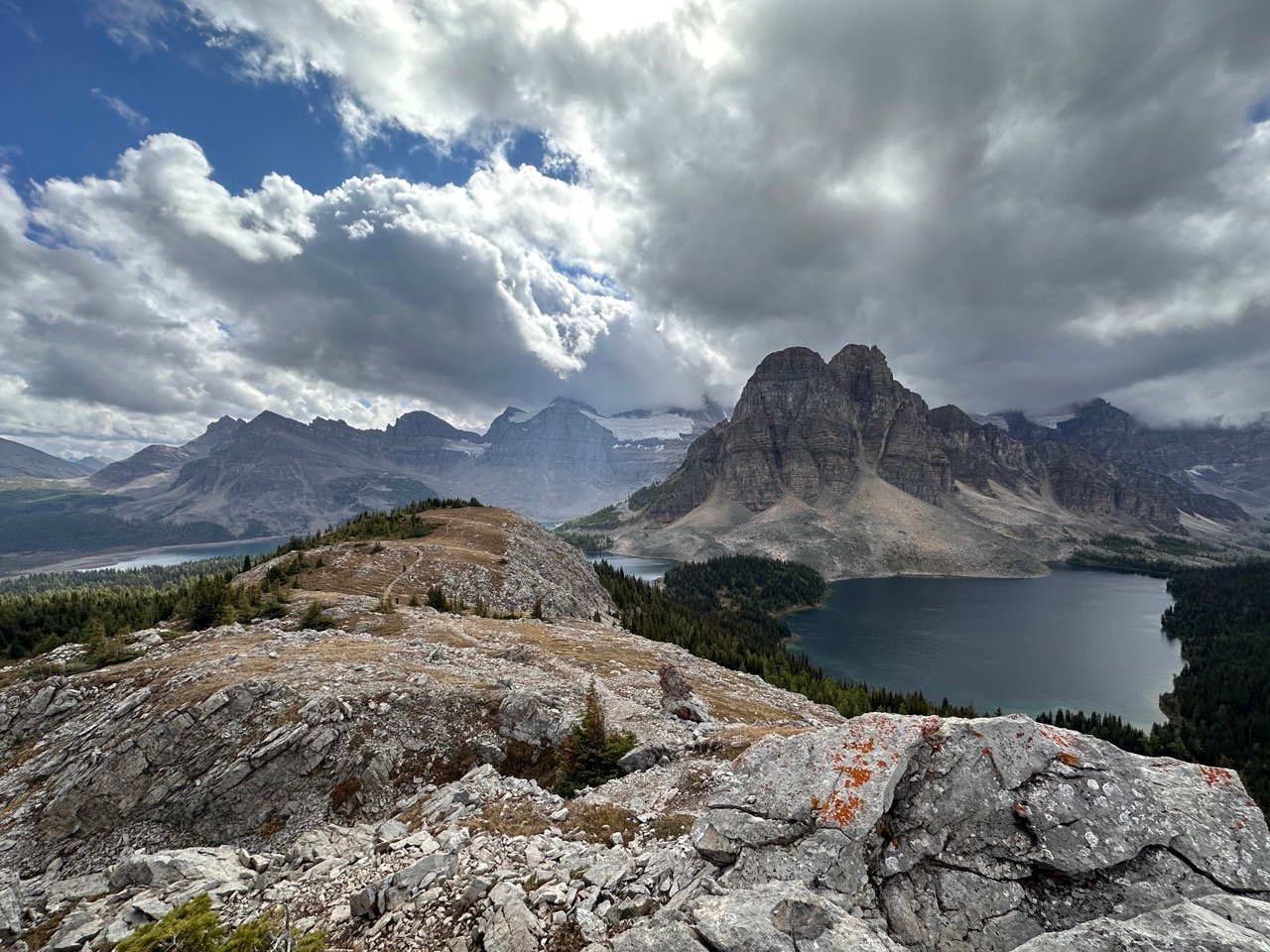
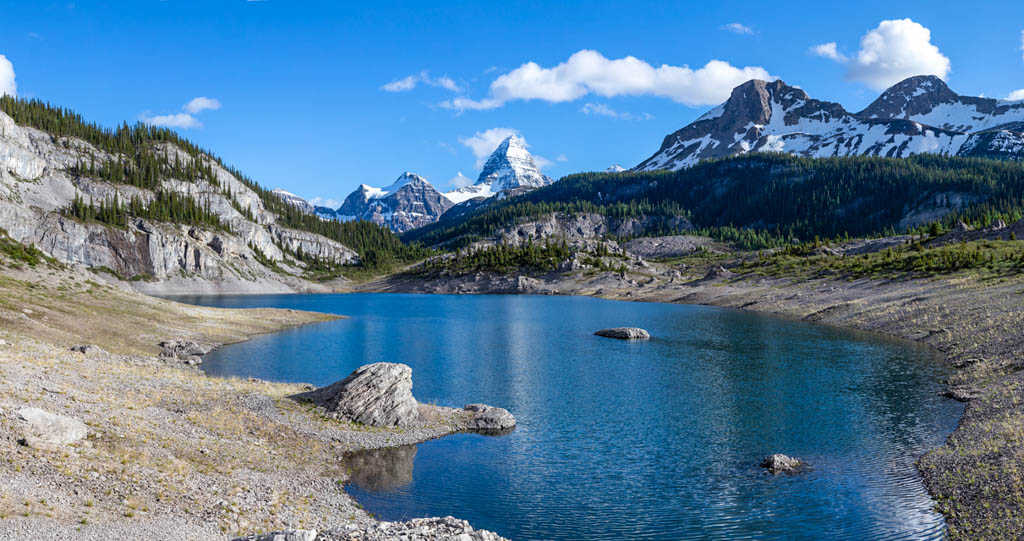
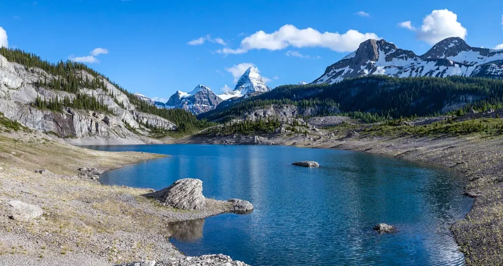
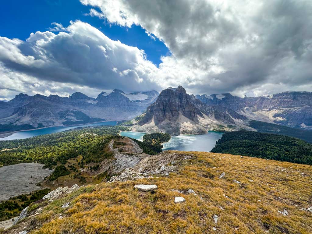
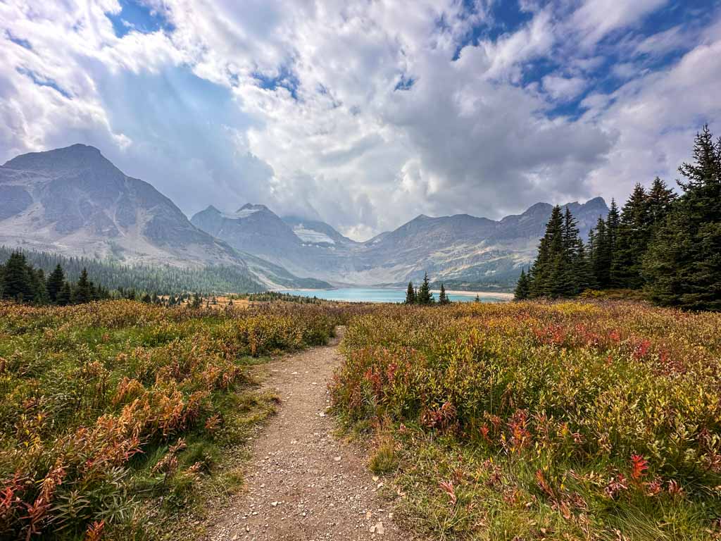
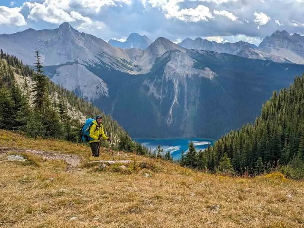
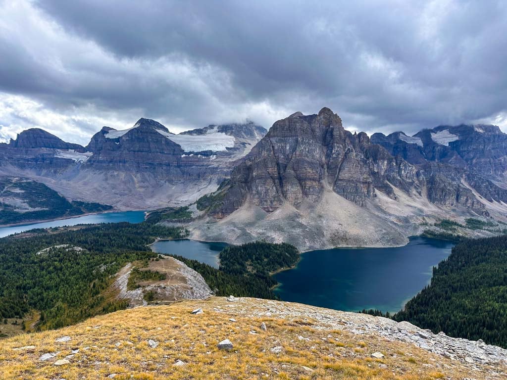
With its prominent Matterhorn shape, Mount Assiniboine is one of the most photographed peaks in the Canadian Rockies. And that makes hiking to Mount Assiniboine one of the most spectacular backpacking trips near Banff.
I had dreamed of visiting for years, but when it came time to plan my trip, I was overwhelmed with information. There are so many campgrounds and access routes to consider! I’m a hiking guidebook author who has hiked all over BC and the Canadian Rockies, so doing hiking research is my jam – I figured out the best way to get there and the best places to camp.
My visit to Assiniboine was gorgeous, and I can’t wait to go back (probably to try one of the other access routes). In this guide, I’ve got all the info I used on my hike so that you can plan your own epic Mount Assiniboine hiking trip.
My guide to hiking to Mount Assiniboine Provincial Park includes:
- Quick facts about Mount Assiniboine including hiking distances, how long it takes, where to camp, and more
- Mount Assiniboine trail maps with all key locations marked
- Reservations: important dates plus booking tips
- How much does it cost: a complete breakdown of all fees
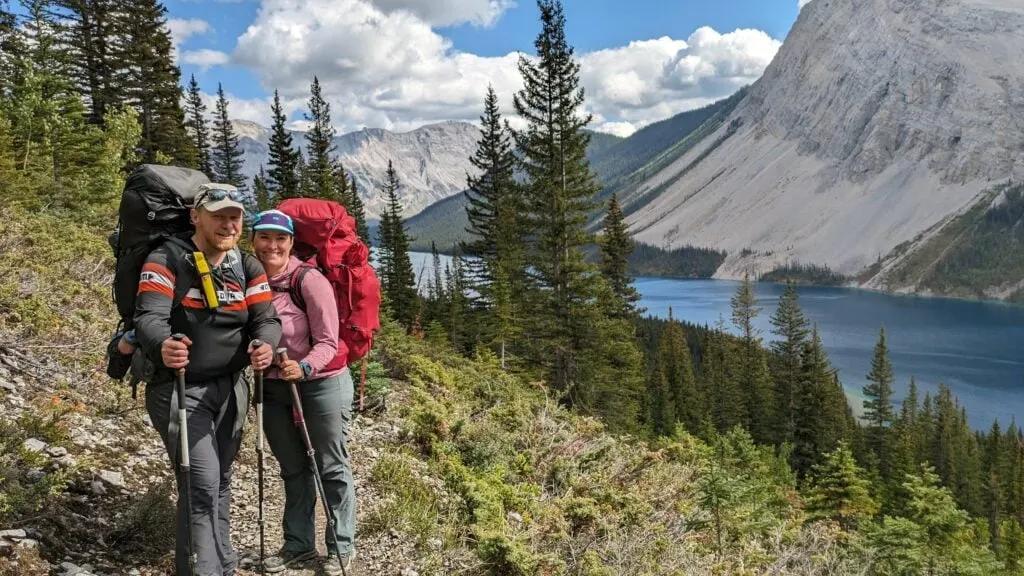
- Route options: how to take a helicopter and five hiking routes to the core area
- How to get to the trailheads: driving directions and info about parking and shuttles
- Where to stay at Mount Assiniboine: info on camping, huts, and the lodge
- Day hikes at Mount Assiniboine: where to hike in the core area including iconic Nub Peak
- Mount Assiniboine itineraries from several trailheads
- Mount Assiniboine hiking tips: advice for bears, weather, photography, and more
This is a sensitive wilderness area. Learn how to Leave No Trace to keep the wilderness wild. Make sure you are prepared by bringing the 10 Essentials. Get ready for adventure with this checklist of things to do before every hike.
Hey there: Some of the links in this post are affiliate links, which means I earn a small commission at no cost to you. Thanks for your support. -Taryn

Mount Assiniboine Quick Facts
Description: Mount Assiniboine is a spectacular 3618-metre peak, nicknamed the Matterhorn of the Rockies. The core area of Mount Assiniboine Provincial Park is a popular place for day hikes with incredible views of Mount Assiniboine and the surrounding peaks. However, the park is very remote – it takes one or two days to hike into the park (there are no roads) and there are several approach routes to choose from.
Location: Mount Assiniboine Provincial Park is located in the Canadian Rockies southwest of Banff and Canmore. The park borders Banff National Park and Kootenay National Park.
Pronunciation: “Uh-sin-a-boyn”
How to Get There: There are five hiking routes into the park. You can also fly in by helicopter. More info in the Route Options section below.
Distance: 25.5 km to 32.3 km each way to the core area (depending on route) plus more for day hikes
Elevation Gain: 766 m to 1625 m to the core area (depending on route)
Difficulty: Moderate (if you break up the hike into the core area into two days)
How Many Days to Spend at Mount Assiniboine: Ideally 4 or 5.
Best time to Hike to Mount Assiniboine: Early July to late September.
Mount Assiniboine Weather: Mount Assiniboine is high in the Canadian Rockies and the mountains make their own weather. In July and August, the average high temperature is 23°C and the average low is 7°C. Thunderstorms in the afternoon are common. Use my picks for the Best Weather Apps for Hiking to see the forecast for your trip. I had a lot of rain and snow on my early September trip. The Mount Assiniboine webcam is also helpful.
Mount Assiniboine Reservations and Cost: You must make reservations to camp at most campgrounds in the Assiniboine core area and on the hike in (although there are some first-come, first-served campgrounds). The cost of your trip will vary depending on your itinerary. See the reservations and costs section below for a full breakdown.
What to Bring to Mount Assiniboine: This is a remote hiking trip, so you will need to bring typical backpacking gear. Don’t forget a waterproof jacket and warm layers as the weather can get cold and wet fast. Use my backpacking checklist to make sure you have everything you need and my guide to reducing your backpack weight so you don’t over pack.
Wildlife at Mount Assiniboine: The trail is in bear country (both black bears and grizzly bears). Carry bear spray, hike in a group, and make noise, especially in brushy areas. Use campground cooking areas and store all your food in toiletries in bear lockers. Read my bear safety tips for backpackers for more info.
Mount Assiniboine Rules: Dogs are allowed on-leash. No fires or drones.
Indigenous Context: The Mount Assiniboine area is in the traditional territory of the Tsuut’ina, Michif Piyii (Mestis), Niitsítpiis-stahkoii (Blackfoot / Niitsítapi), Ĩyãħé Nakón mąkóce (Stoney) and Ktunaxa ɁamakɁis. The government forced Indigenous people to leave soon after Banff National Park was created in 1885 and prohibited them from accessing their traditional territory to hunt, fish, gather, and conduct cultural practices. George Dawson, an early settler surveyor, named the mountain after the Indigenous Stoney people, who the Cree called “Assin Bwan”.
Have questions about Mount Assiniboine? Join the Mount Assiniboine Facebook Group to connect with other hikers!

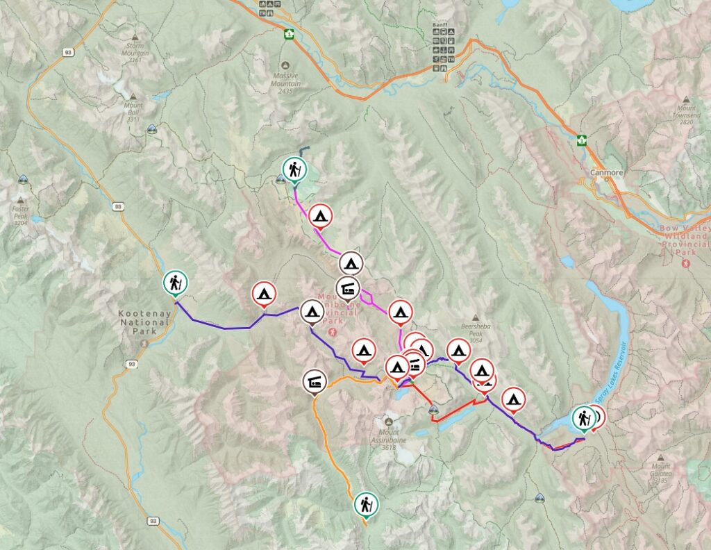
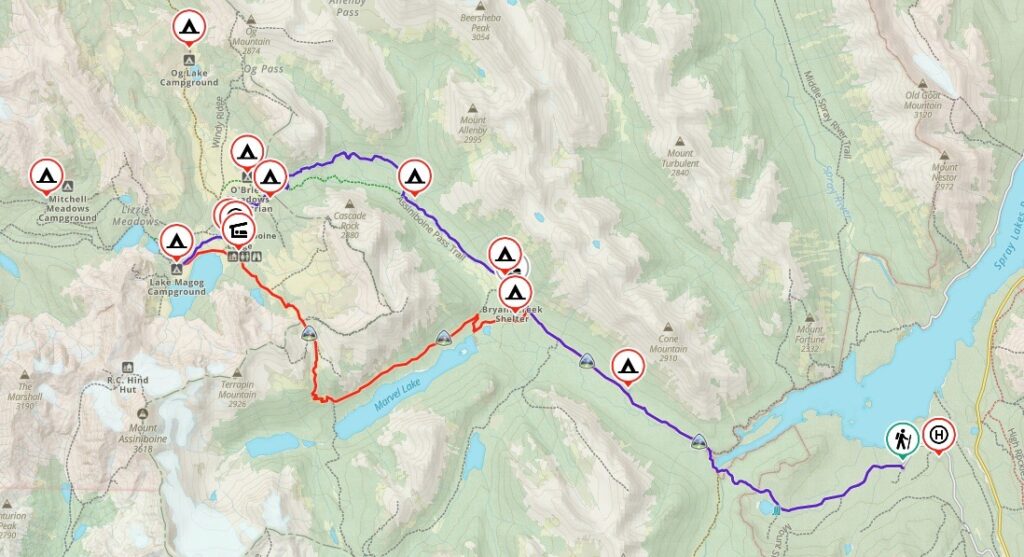
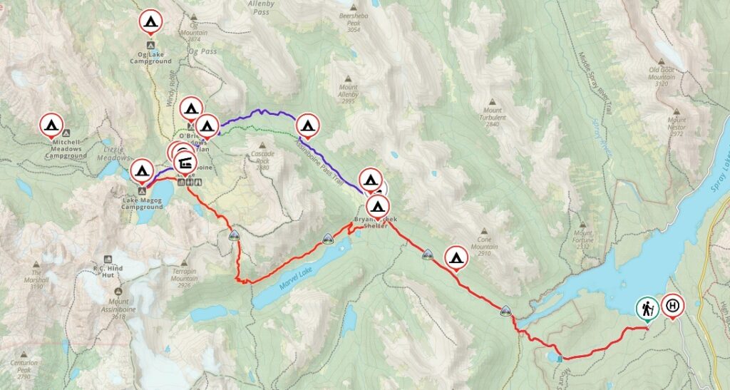
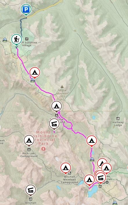
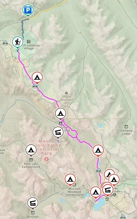
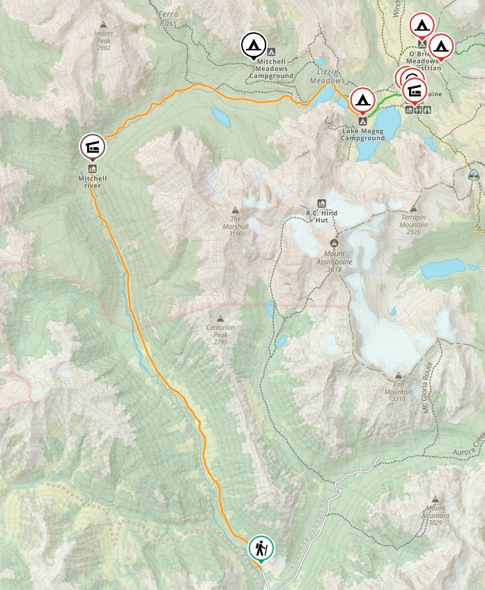
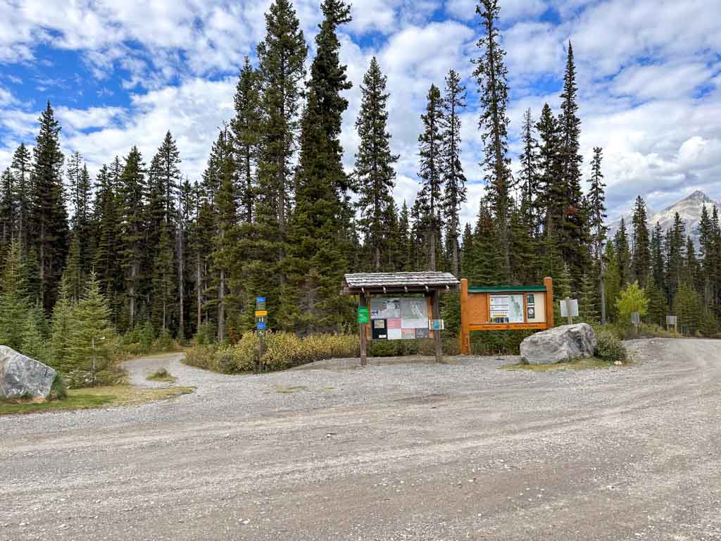
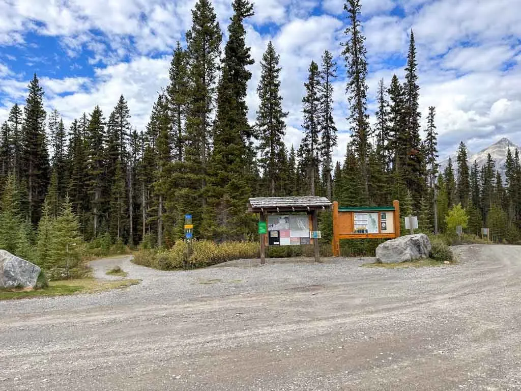
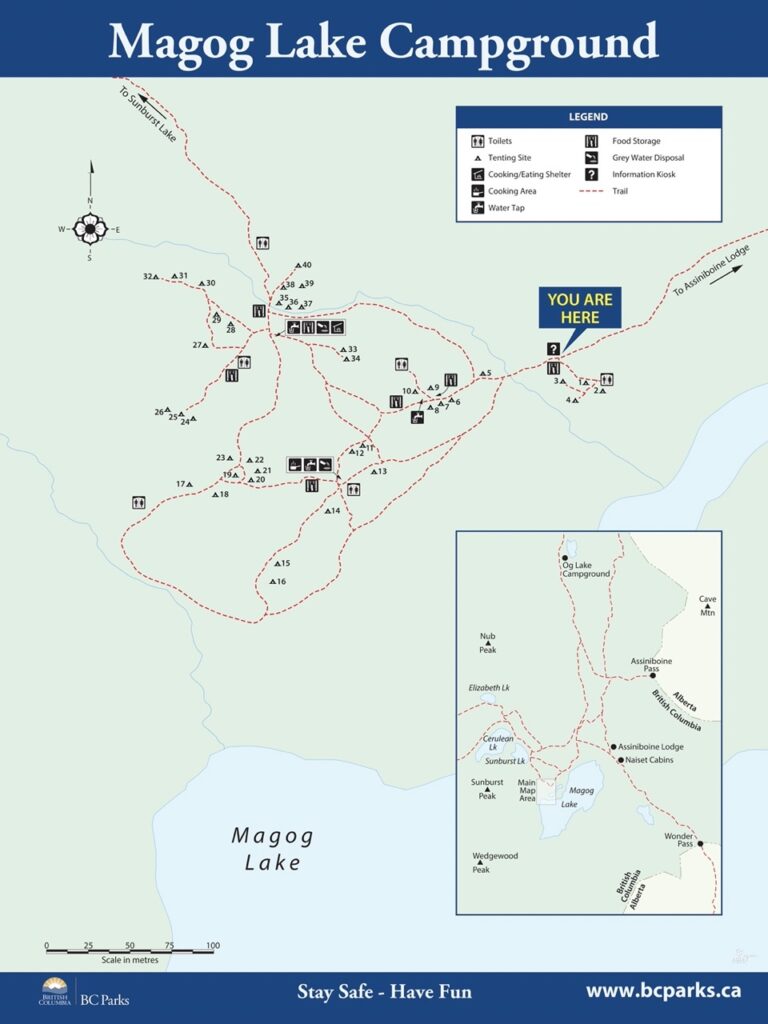
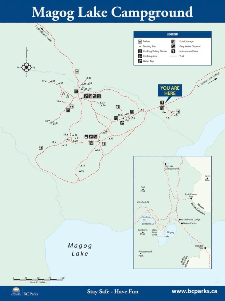
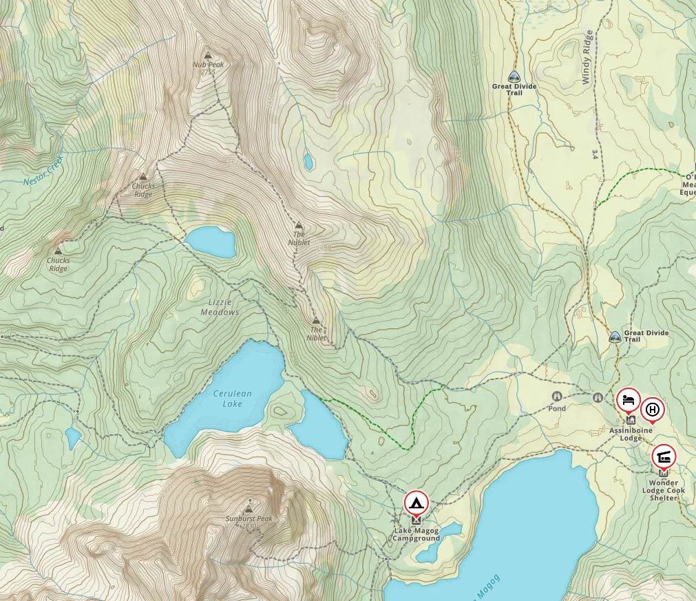
Mount Assiniboine Trail Map
The trails in the Mount Assiniboine core area and on some of the routes into the core are well-marked and easy to navigate.
However, there are a lot of trails and it can be tough to visualize where everything is. As well, the BC Parks map sucks because it doesn’t show the route from Mount Shark Trailhead and it doesn’t have elevation contour lines.
I have the Gem Trek Banff and Mount Assiniboine Map. It’s by far the best map of the area since it shows all the trails with tons of detail. It’s also printed on waterproof and tear-resistant paper.
I also used the Gaia GPS app on my hike. It was helpful to know where I was on the trail or to figure out how much further it was to the next landmark. I made a bunch of custom Gaia GPS trail maps for you that you’ll find in this post in the route options section. You can save and export my gpx files from these routes to use on your own trip. All Trails+ is also great.
Mount Assiniboine Reservations
You need reservations to stay in the core area at Mount Assiniboine at Lake Magog Campground, Og Campground, the Naiset Huts, and Assiniboine Lodge. You also need reservations to camp at Banff National Park campgrounds on the hike into the core area.
And starting in 2024, you need reservations to camp at Porcupine Campground on the hike into Assiniboine from Sunshine.
However, you do not need reservations at the first-come, first-served BC Parks campgrounds on the west side of the park and at Mitchell Meadows near the core. You can find more details about each campground in the Camping section below and more info on each hiking trail into the core in the Route Options section below.
Parks Canada Reservations open in January or February each year. In 2026, backcountry reservations for Banff National Park opened on January 26, 2026, at 8 a.m. Mountain Time. You must book on the Parks Canada Reservations website.
BC Parks reservations open online 3 months before your trip. You can book your entire BC Parks itinerary staring three months before your trip. So if you want to book August 1 at Porcupine and August 2 and 3 at Lake Magog, you can reserve all three nights starting on April 1.
Naiset Hut reservations are by phone or online. Reservations for 2026 open on January 13, 2026 at 8:30 a.m. Mountain Time.
Reservation Tips:
- Book as soon as reservations open – popular dates sell out in the first hour.
- Have everyone in your group online and trying to book to maximize your chances.
- Have a backup plan in case you don’t get your first choice of campsites.
- Due to the timing of reservations, it can be tough to line up itineraries with campsites in both Banff National Park and Mount Assiniboine Provincial Park, especially since you have to reserve Banff first. However, campsites in Banff are much less popular and you may be able to pick up a weekday booking after you get your Assiniboine reservations. (See the Camping and Itinerary sections below.)
- Practice using the booking systems before they open so you know how to click through the options fast on opening day. For Parks Canada reservations, you will need to know your access point – pick Bryant Creek for the Br campsites and Sunshine for Howard Douglas Lake.
- If you didn’t get a reservation, keep checking back as people cancel and spots open up. A more efficient way is to sign up for a camping cancellation notification app like Campnab or Schnerp. Read my guide to camping cancellation apps to find out how they work and which one I recommend.
- Find more details and tips for booking in my guide to making backcountry reservations in BC.
Mount Assiniboine Fees and Costs
The cost of your trip to Mount Assiniboine depends a lot on which route you take and how long you stay. Here’s a quick breakdown of costs:
Camping at Lake Magog, Og Lake or Porcupine: $25/person per night + $6/night/tent pad reservation fee
Camping at other BC Parks campgrounds: free
Camping at Banff National Park campgrounds: $13.50/person/night + $11.50 flat-rate reservation fee for your whole booking
Naiset Huts: $150-$240/hut/night
Assiniboine Lodge: $440-$645/person/night
National Park entry fees: $11/person/day or $22/vehicle (up to 7 people)/day – or buy a Discovery Pass for $151.25 that covers up to 7 people in the same vehicle for an entire year
Kananaskis Conservation Pass: $15/vehicle/day or $90/vehicle/year
Sunshine gondola: $68/person
Helicopter flight: $245-$275/person/each way
Flying gear in/out of the park: $6/pound/each way


Mount Assiniboine Route Options
Mount Assiniboine Provincial Park sits high in the Canadian Rockies. Banff National Park, Kootenay National Park, and Crown land surround the park and there are no roads into it. That means it is a long hike to get there.
There are six main ways to get to the park: five hiking routes and the option to fly in by helicopter. There are also several mountaineering routes into the park, but they require technical climbing and glacier travel. Below I’ve got details on each of the route options for hikers.
Here’s a quick comparison table of the hiking options:
| Route | Distance | Time | Elevation Gain | Elevation Loss |
|---|---|---|---|---|
| Assiniboine Pass | 25.5 km | 8-11 hours | 766 m | 327 m |
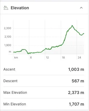
| Wonder Pass | 26.7 km | 8-11 hours | 1003 m | 567 m |
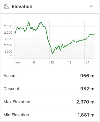
| Sunshine/Citadel Pass | 27.4 km | 9-12 hours | 956 m | 952 m |
| Simpson River | 32.3 km | 11-13 hours | 1625 m | 676 m |
| Mitchell River | 24.9 km | 8-14 hours | 1230 m | 245 m |
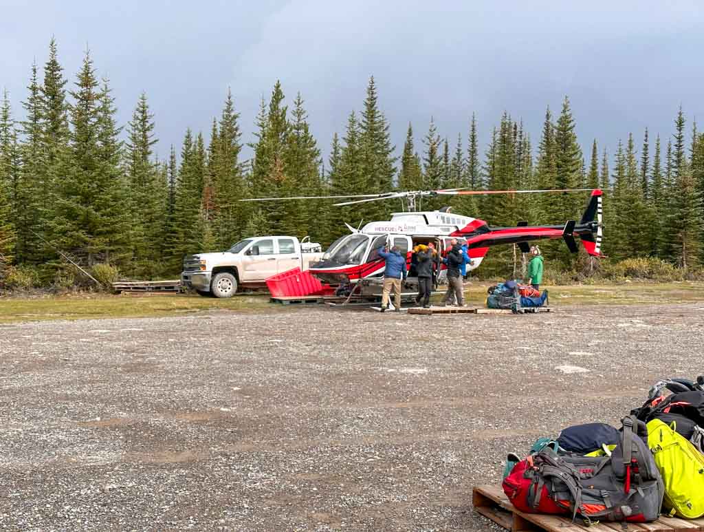
Helicopters to Mount Assiniboine
You can also get to Mount Assiniboine by helicopter instead of hiking. You can fly directly from Canmore or from the Mount Shark Helipad on Wednesdays, Fridays, Sundays, and holiday Mondays. The helicopter will drop you off next to the Assiniboine Lodge. From there it’s a 2 km walk to the Lake Magog Campground.
You can fly one way and hike the other way or fly both ways. You must have a valid lodge, Naiset huts or campground booking at Lake Magog or Og Lake or they won’t let you fly. All bookings are managed through Assiniboine Lodge. In 2026, the first day you can book your heli flight is April 15, 2026.
Flights are 10 minutes long and pretty scenic. If you are flying from Mount Shark, keep in mind that there may be up to 12 flights per day and you may have to wait up to 2 hours for your flight to depart. You likely won’t get to camp until after lunch.
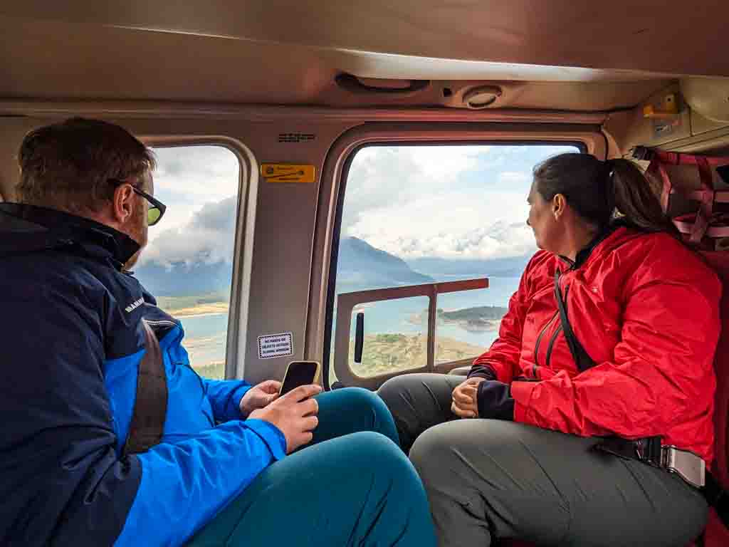

In summer 2026, flights are $275/person from Canmore or $245/person from Mount Shark plus 5% tax.
The Mount Shark Helipad is NOT at the Mount Shark trailhead. They are about 2.2 km apart by road or 1.5 km by trail.
If you hike to Mount Assiniboine and want to fly out instead of hiking, it may be possible – ask at the Lodge during tea time or ask the ranger who comes through Lake Magog campground every evening. You must have a booking at Lake Magog or Og Lake to fly out.
Luggage
You can bring up to 40 lbs of luggage as long as your bag isn’t too big. There is a fee for overweight baggage, but in my experience, they don’t weigh your bags or check that they aren’t too big. You can’t have anything attached to the outside of your bag – put everything inside or send additional gear in a separate bag.
Your bags might not be on the same flight as you so label your gear – our group lost an expensive pair of carbon fibre poles that another hiker must have mistaken as theirs.
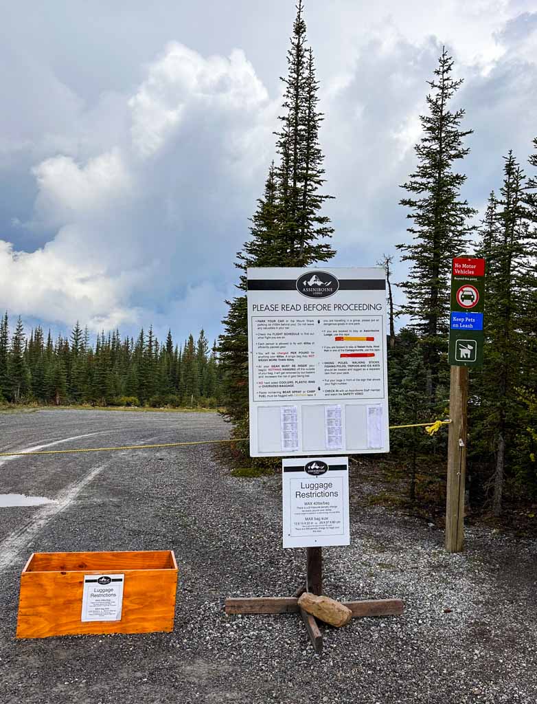

You can also pay to have your gear flown in or out for $6/pound/each way. You can set this up beforehand, or make arrangements on the day you fly either from Canmore or at the Assiniboine Lodge.
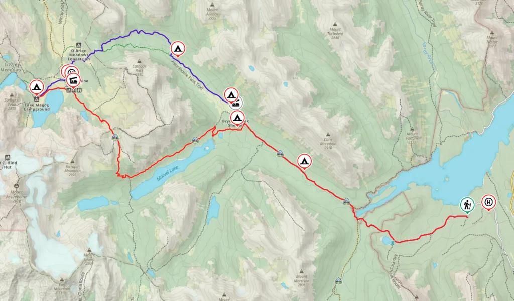
Hiking via Assiniboine Pass
Trailhead: Mount Shark/Bryant Creek
Distance: 25.5 km
Elevation Gain: 766 m
Elevation Loss: 327 m
Time: 8 to 11 hours
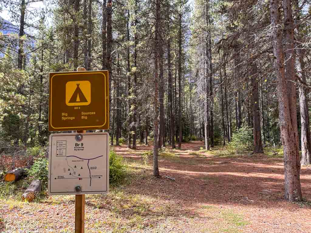
Campsites: Big Springs (Br9), Marvel Lake (Br13) (via side trail), McBride’s Camp (Br14), Allenby Junction (Br17)
Pass Needed: Kananaskis Conservation Pass required to park at the Mount Shark Trailhead
Pros: Easiest and most straightforward hike.
Cons: Least scenic.


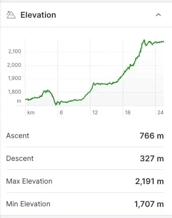
Key Distances
| Location | Distance | Elevation |
|---|---|---|
| Mount Shark Trailhead | 0 km | 1745 m |
| Bryant Creek Bridge | 6.3 km | 1720 m |
| Big Springs Camp (Br9) | 9 km | 1745 m |
| Wonder Pass Junction/Marvel Lake Camp (Br13) | 12.4 km | 1830 m |
| Bryant Creek Shelter (closed) | 13 km | 1865 m |
| McBride’s Camp (Br14) | 13.4 km | 1870 m |
| Allenby Junction Camp (Br14) | 16.5 km | 1875 m |
| Lower Horse Trail Junction | 16.8 km | 1880 m |
| Upper Horse Trail Junction | 21.4 km | 2125 m |
| Assiniboine Pass | 22 km | 2190 m |
| O’Brien Camp Junction | 22.2 km | 2150 m |
| Sunshine Route Junction | 23.7 km | 2165 m |
| Assiniboine Lodge Junction | 24 km | 2175 m |
| Lake Magog Camp | 25.5 km | 2180 m |
Assiniboine Pass Route Description
The Assiniboine Pass Route is the easiest and most straightforward way to hike to the core area of Mount Assiniboine Provincial Park. The first half of the route is in a boring forest. However, once you get to the Wonder Pass junction, it opens up a bit more and you get some views of the surrounding peaks.
It’s also worth noting that this route is the same one that helicopters take, so it will be noisy on Sunday, Wednesday and Friday mornings.
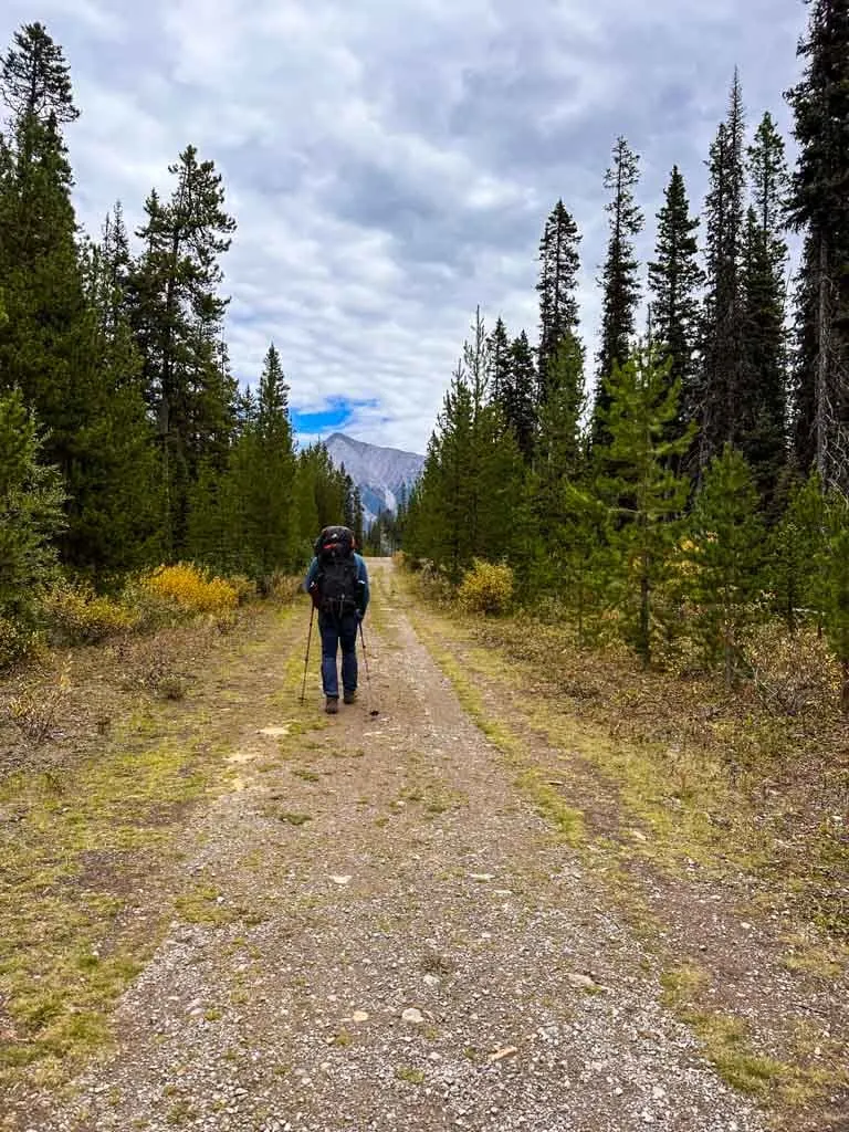
This route starts from the Mount Shark Trailhead in Spray Valley Provincial Park the Kananaskis Valley. It follows a wide gravel road through the Mount Shark Nordic ski area to Wattridge Lake, then descends to the end of the Spray Lakes Reservoir. From here, it becomes more of a trail. After you cross the bridge over Bryant Creek you will enter Banff National Park.

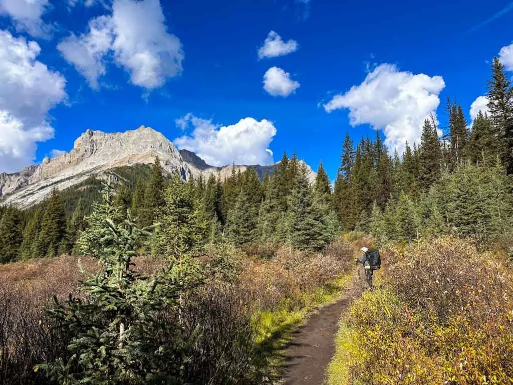
The trail follows Bryant Creek up the valley to the pass. Along the way, you will pass Big Springs Camp (Br9), the turn-off to the Wonder Pass Route, Marvel Lake Camp (Br13), McBride’s Camp (Br14), and Allenby Junction Camp (Br17).

The steep last section of the trail before the pass (called Allenby Pass) is closed to hikers each year between August 1 and September 30 due to increased grizzly activity. However, you can take the Horse Trail instead which stays lower in the valley.
The two routes meet near the top of Assiniboine Pass. From the pass, the trail descends past the turn-off to the O’Brien Meadows Horse and Group camps. Next, pass the junctions for trails to Sunshine/Citadel Pass and the Assiniboine Lodge as you continue towards Lake Magog Campground.
Hiking via Wonder Pass
Trailhead: Mount Shark/Bryant Creek
Distance: 26.7 km
Elevation Gain: 1003 m
Elevation Loss: 567 m
Time: 8 to 11 hours
Campsites: Big Springs (Br9), Marvel Lake (Br13), McBride’s Camp (Br14) (via side trail)
Pass Needed: Kananaskis Conservation Pass required to park at the Mount Shark Trailhead
Pros: Great views along Marvel Lake and at Wonder Pass
Cons: The bottom half of the route through the forest has no views.

Key Distances
| Location | Distance | Elevation |
|---|---|---|
| Mount Shark Trailhead | 0 km | 1745 m |
| Bryant Creek Bridge | 6.3 km | 1720 m |
| Big Springs Camp (Br9) | 9 km | 1745 m |
| Wonder Pass Junction/McBride’s Camp (Br14) | 12.4 km | 1830 m |
| Marvel Lake Camp (Br13) | 12.9 km | 1815 m |
| Wonder Pass | 22.3 km | 2375 m |
| Naiset Huts | 24.9 km | 2190 m |
| Lake Magog Camp | 26.7 km | 2180 m |
Wonder Pass Route Description
The Wonder Pass route shares the same trail as the Assiniboine Pass Route for the first 12.4 km. The Wonder Pass route is tougher than Assiniboine Pass since it has a much steeper ascent. But it has incredible views.
I recommend using this trail for your descent since most of the views will be behind you on your way up. I really liked hiking down this way – it was gorgeous! And that way you can take the gentler route over Assiniboine pass on the way in and avoid the extra climb to Wonder Pass with heavy packs.
After the routes split, the Wonder Pass route does a brief stint in the forest. Then it climbs up onto a shoulder high above Marvel Lake. The next four kilometers have incredible views of the lake. Then the route turns right and starts climbing steeply through the trees to Wonder Pass.

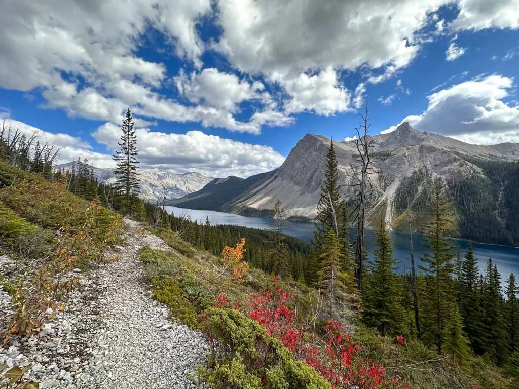
Once you hit the treeline, there are great views down to Marvel Lake, but they are behind you. Near the top of Wonder Pass you can take a side trail to a viewpoint with better views over Marvel Lake. On the other side of the pass, the trail descends through open meadows and stands of larch. It passes Gog Lake and the Naiset Huts before turning onto the lakeshore trail to hike to Lake Magog Camp.

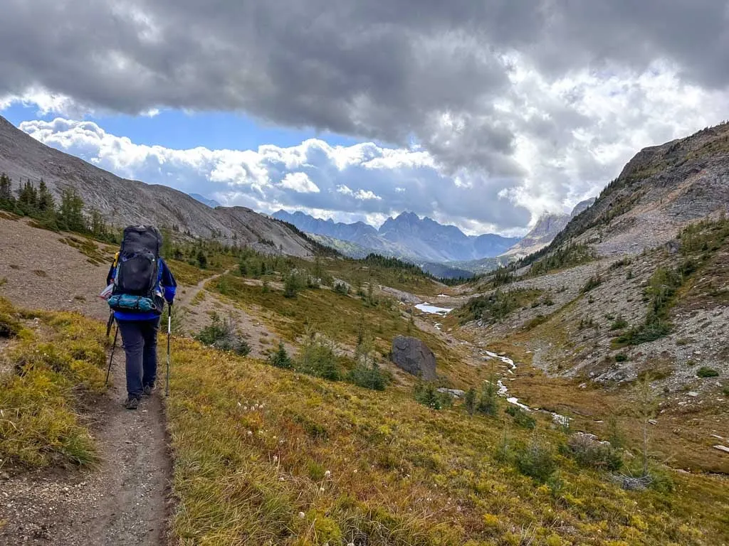
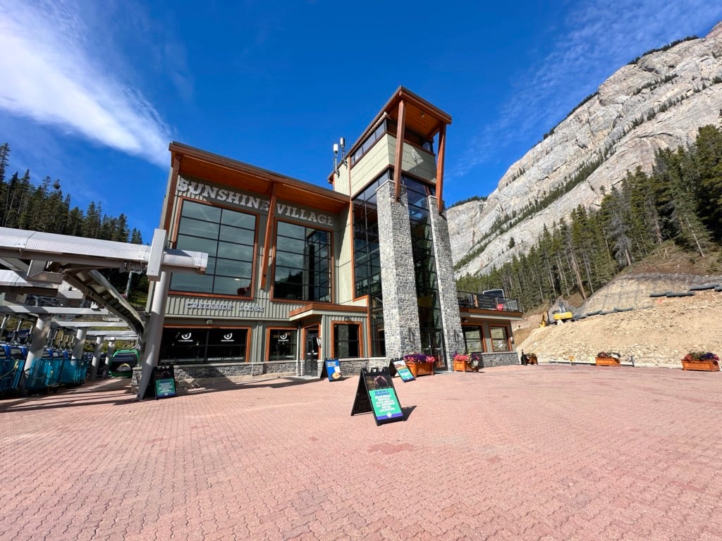
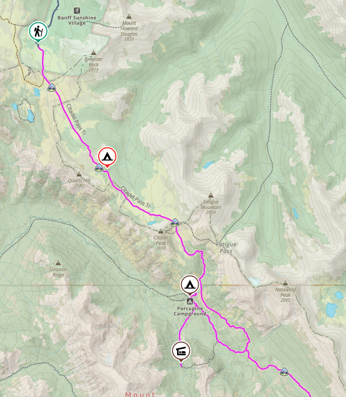
Hiking via Sunshine/Citadel Pass
Trailhead: Sunshine Village
Distance: 27.4 km
Elevation Gain: 956 m
Elevation Loss: 952 m
Time: 9 to 12 hours
Campsites: Howard Douglas (Su8), Porcupine (via side trail), Og Lake
Passes Needed: National Park Pass required to park at Sunshine; Sunshine Gondola Ticket to get to the top of the gondola
Pros: Best scenery
Cons: Lots of ups and downs, more expensive
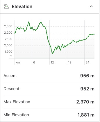
Key Distances
| Location | Distance | Elevation |
|---|---|---|
| Citadel Pass Trailhead | 0 km | 2200 m |
| Howard Douglas Camp (Su8) | 5.5 km | 2260 m |
| Citadel Pass | 9 km | 2370 m |
| Upper Porcupine Camp Junction | 12.1 km | 2010 m |
| Lower Porcupine Camp Junction | 18.8 km | 1940 m |
| Og Lake Camp | 20.8 km | 2060 m |
| Assiniboine Pass Junction | 25.5 km | 2165 m |
| Assiniboine Lodge Junction | 25.8 km | 2175 m |
| Lake Magog Camp | 27.4 km | 2180 m |
Sunshine Village/Citadel Pass Route Description
The route from Sunshine Village is arguably the most scenic way to hike to Mount Assiniboine, but it has lots of elevation gain and loss and is more expensive since you have to pay for the gondola. Despite that, many hikers think it is easier since you don’t have a big climb all at once.
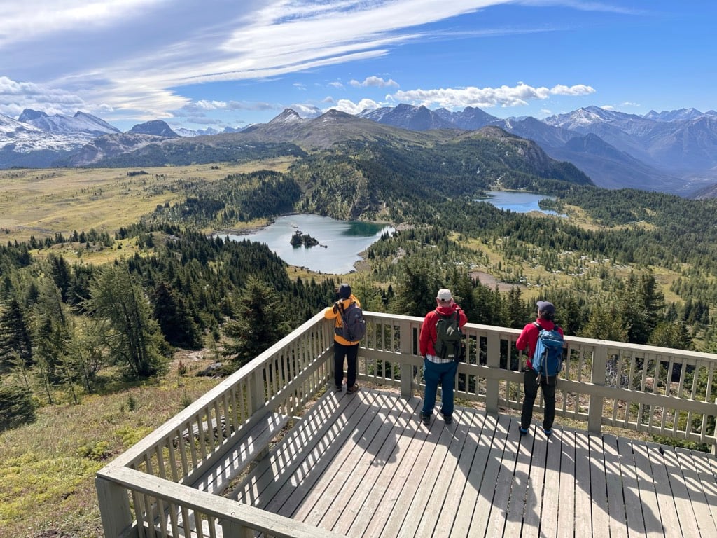
The trip formally starts from the top of the Sunshine Gondola, so you will have to buy a ticket for about $68. The views from the gondola are incredible, and your gondola ticket includes a ride on the Standish Chairlift to save you even more elevation gain.
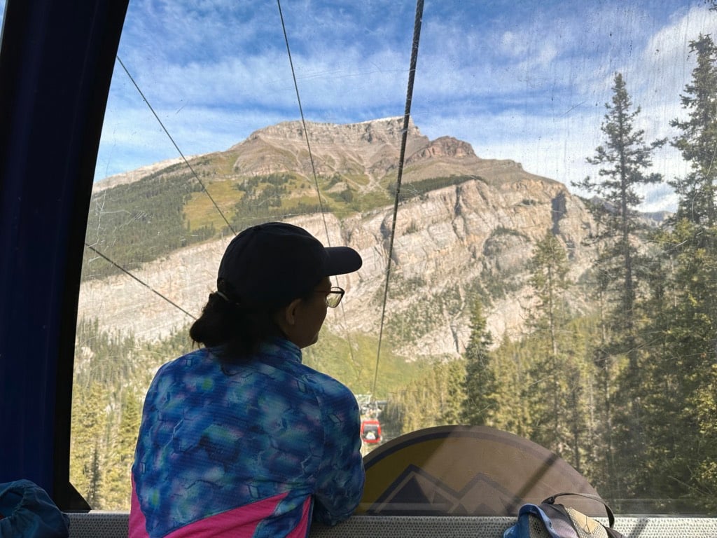

Plus, the views from the Standish Viewing Deck are incredible! On your hike from the chairlift to hook up with the Citadel Pass trail you’ll also pass by gorgeous Rock Isle Lake. My guide to hiking at Sunshine Meadows has more info.

You can also walk up the dusty access road to the top of the gondola. This adds 5.5 km and 510 m of elevation gain to your trip. Dogs aren’t allowed on the gondola – they have to walk up. Check the gondola hours before your trip!
The first section heads uphill before descending to Howard Douglas Lake Campground. Next, you go up and over Citadel Pass before descending steeply to a junction. You can descend even further to Porcupine Campground in Golden Valley on a side trail, or continue along the main trail.
The trail has lots of little ups and downs as it passes through the Valley of Rocks, but in general, it trends gently uphill to Og Lake Campground in beautiful meadows. From Og Lake, the trail goes through more meadows. You will pass the junctions with the Assiniboine Pass Trail first and then the trail to Assiniboine Lodge before arriving at Lake Magog Campground.
Note: There aren’t very many water sources on this trail, so it’s best to fill up where you can. If you aren’t planning to stop at Porcupine, carry enough water from Howard Douglas Lake to get you to Og Lake.
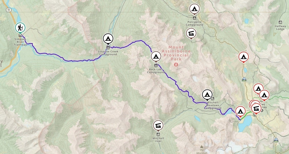
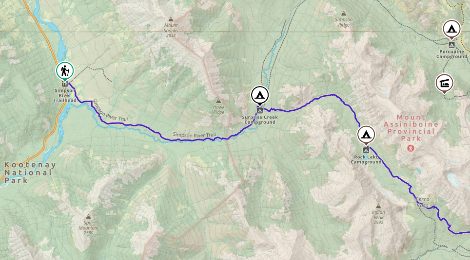
Hiking via Simpson River/Ferro Pass Trail
Trailhead: Simpson River
Distance: 32.3 km
Elevation Gain: 1625 m
Elevation Loss: 676 m
Time: 11-13 hours
Campsites: Surprise Creek, Rock Lake, Mitchell Meadows
Pass Needed: National Park pass required to park at the trailhead
Pros: Solitude, easy to get first-come, first-served campsites
Cons: Half of the hike is in a burned forest, high bear activity.
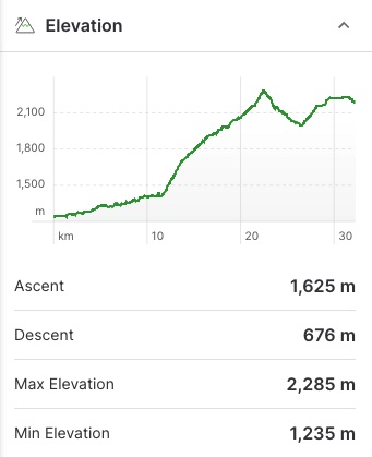

Key Distances
| Location | Distance | Elevation |
|---|---|---|
| Simpson River Trailhead | 0 km | 1240 m |
| Surprise Creek Camp | 11.4 km | 1410 m |
| Rock Lake Camp | 18.5 km | 1975 m |
| Ferro Pass | 22.5 km | 2285 m |
| Mitchell Meadows Camp | 26.6 km | 1995 m |
| Mitchell River Junction/Cerulean Lake | 29.6 km | 2220 m |
| Lake Magog Camp | 32.3 km | 2180 m |
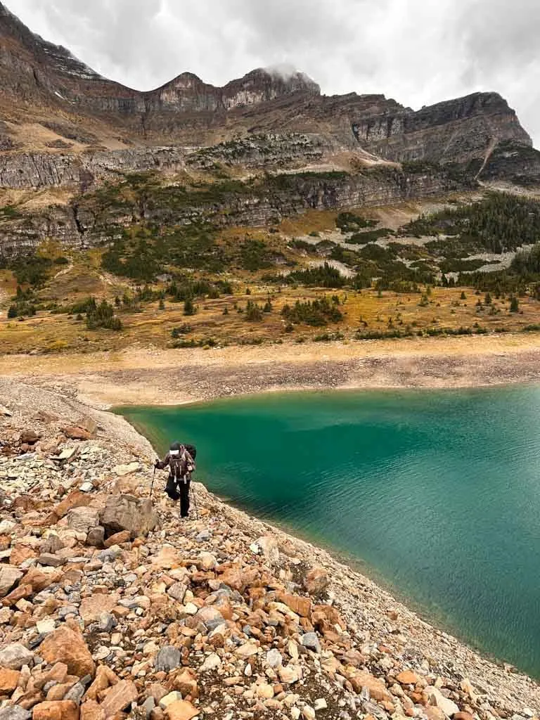
Simpson River/Ferro Pass Route Description
You won’t find much information about this route into the Mount Assiniboine Core area since several wildfires burned through this area and it has closed for many years. However, the area is starting to recover and a BC Parks crew cleared the trail in August 2023 so it should be in good condition.
However, it is worth noting that the area is known for high grizzly bear activity. Hike in a group, make noise, and carry bear spray.
This obscure route is best for those who want solitude and to see the quieter eastern side of the park. It starts on Highway 93 in Kootenay National Park. Cross the Simpson River on a suspension bridge and follow the trail up the river through the burn area to the boundary between Kootenay National Park and Mount Assiniboine Provincial Park
Continue to Surprise Creek, which no longer has a bridge. However, apparently, it is straightforward to ford it a short distance past the old bridge location. Surprise Creek Campground is on the other side. The trail continues uphill through the forest alongside Surprise Creek, passing Rock Lake Campground, before cresting Ferro Pass in a meadow.
From there, it heads downhill through the trees to Mitchell Meadows Campground, then past Cerulean and Sunburst Lakes to finish at Lake Magog Campground.
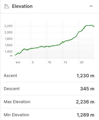
Hiking via Mitchell River Trail
Trailhead: Mitchell River Trailhead
Distance: 24.9 km
Elevation Gain: 1230 m
Elevation Loss: 245 m
Time: 8-14 hours
Campsites: Mitchell River Shelter
Pass Needed: None
Pros: Short hike, solitude
Cons: Long drive to the trailhead, unmaintained trail, multiple river crossings

Key Distances
| Location | Distance | Elevation |
|---|---|---|
| Mitchell River Trailhead | 0 km | 1565 m |
| Mitchell River Shelter | 6 km | 1625 m |
| Simpson River Junction/Cerulean Lake | 14.3 km | 2220 m |
| Lake Magog Camp | 16.9 km | 2180 m |
Mitchell River Route Description
This route to Mount Assiniboine is very obscure, unmaintained and not very well travelled, except by the occasional horseback rider. It also fords the Mitchell River many times, which can be challenging. Expect lots of downed trees and route finding.
The Mitchell River Trail starts on Crown Land outside the park near the Baymag Mine. Getting to this trailhead involves lots of backroad driving. You must get permission to park at the mine and walk through their land. From the mine, you will walk up a gravel road for six kilometres. Then trail follows the Mitchell River closely as it heads uphill through the forest past the Mitchell River Shelter.
Pass through intermitent meadows before joining the more popular trails around Cerulean and Sunburst Lakes to finish at Lake Magog Campground.

How to Get to the Trailheads
There are four different trailheads. Below I’ve got driving directions for each one as well as info on how to get from one trailhead to another if you are doing a traverse hike.
Pro tip: I’ve heard of car break-ins at these trailheads, especially at Mount Shark. Don’t leave anything in your car.
I also made a custom Google Map for you that shows all of the trailheads and driving routes. Click here to zoom in and explore.

How to Get to Mount Shark/Bryant Creek Trailhead
The Mount Shark Trailhead is located in Spray Valley Provincial Park south of Canmore. To get there, you will need to drive the Smith-Dorrien Trail (Highway 742) south from Canmore for 40 km. From there you drive 5 km on Mount Shark Road to its end at a large parking area.
The whole drive takes 45 minutes to an hour and is mostly on well-graded gravel roads that are fine for all vehicles. In general, I found it really scenic with incredible views of the mountains along the Spray Lakes Reservoir.
There is no public transportation to this trailhead. Click here for Google Maps driving directions. Keep in mind that you will lose cell service after you leave Canmore.
Note: You must have a Kananaskis Conservation Pass to park here. You can buy one online before you arrive.
How to Get to Sunshine/Citadel Trailhead
Sunshine Village is just 20 minutes north of the town of Banff on Sunshine Road. To get there, head north on Highway 1 from Banff, then take the marked Sunshine exit. Continue up the Sunshine Road for another 8 km to its end at the huge parking lot. Click here for Google Maps driving directions. You likely will lose cell service on the Sunshine Road.
Sunshine also offers a FREE shuttle bus service from Banff to the gondola base several times a day. You can also take a taxi from Banff.
Once you get to the Sunshine parking lot, you can pay to ride the gondola to the top or walk the 5 km road. The trailhead is at the top of the gondola. Be sure to look up current gondola hours, especially if you hike back this way.
Note: You must have a National Park Pass to park here.

How to Get to Simpson River Trailhead
The Simpson River Trailhead is located on Highway 93 in Kootenay National Park. The 78-kilometre drive from Banff via Highway 1 and Highway 93 takes about 55 minutes. The parking area is small but rarely busy. Click here for Google Maps driving directions. There is no public transportation to this trailhead. You will likely lose cell service after you leave Banff.
Note: You must have a National Park Pass to park here.
How to Get to Mitchell River Trailhead
This trailhead is located on Crown Land at the Baymag Mine. To get here involves quite a bit of backroad driving. The gravel roads are shared with mining trucks so they are well-maintained, but you do have to watch for fast-moving industrial traffic.
From Radium Hot Springs, take Highway 93 east for 20 km. Turn right onto Settler’s Road, which is gravel and follow it for 12 km. At a fork, stay left to take the Cross River Forest Service Road over the bridge towards Nipika Mountain Resort. Go past the resort, staying on Cross River FSR as the road swings north.
Stay on Cross River FSR for 20 km. At another fork, bear left onto Mitchell Creek FSR. Follow this road for another 6 km to the Baymag Mine. Ask permission at the mine to park and walk through the site to start your hike. Allow at least an hour for the drive. Click here for Google Maps Driving Directions. There is no public transportation to this trailhead.
There is no cell service for the drive and the backroads can be confusing, so I recommend using All Trails+ or Gaia GPS app to navigate.
How to Get Between Trailheads
With several routes into the core area of Mount Assiniboine, putting together a one-way hike that combines more than one route sounds appealing. Unfortunately, transportation between trailheads is really challenging – there is no public transportation. (White Mountain Adventures used to offer a shuttle service between trailheads but they stopped offering it.)
The easiest way to get between two trailheads is to have two cars or get dropped off. However, the driving distances between trailheads are long – between 1 and 3.5 hours each way, depending on which trailhead you choose. The trailheads are also quite remote, so hitchhiking would be a long shot.
You can try working with other hikers in the Mount Assiniboine Facebook group to set up a key swap or cooperative car shuttle.
Booking a taxi in Banff or Canmore is also an option, although depending on the distance, it may be very expensive or the company may not want to travel that far. Three Sisters Taxi in Canmore is your best bet. They have fixed rates for transport between Mount Shark, Sunshine, Banff, and Canmore ranging from $250 to $350 for up to 4 people depending on how far you need to go.
The easiest way to do a one-way trip is to fly in or out of Mount Assiniboine from Canmore and then hike in or out via Sunshine. That way you can take the bus from Canmore to Banff and then the shuttle from Banff to Sunshine.
Have questions about Mount Assiniboine? Join the Mount Assiniboine Facebook Group to connect with other hikers!
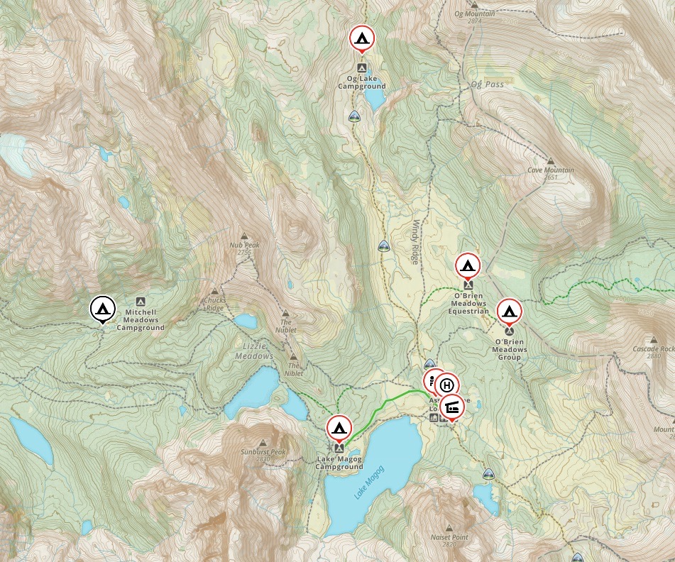
Where to Stay at Mount Assiniboine
The wilderness area around Mount Assiniboine Provincial Park is fairly large with lots of backcountry campgrounds to choose from. There are also huts and a lodge in the core area of the park Below I’ve got the run-down on all the options for places to stay at Mount Assiniboine both in the core area and on the hike in.

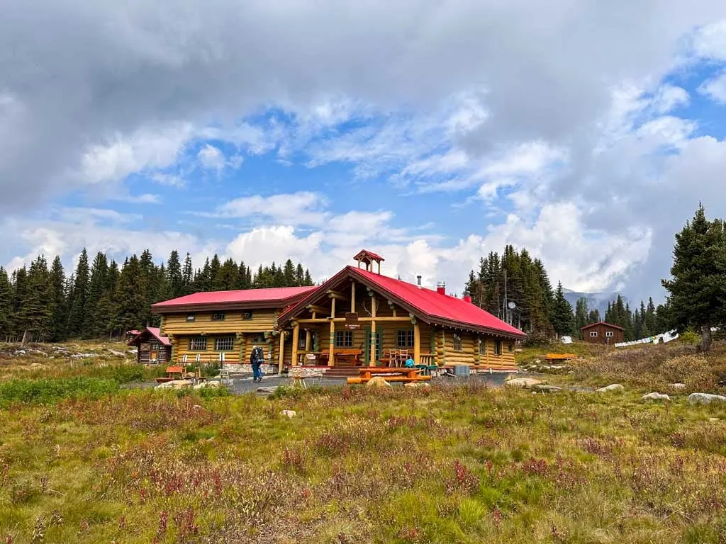
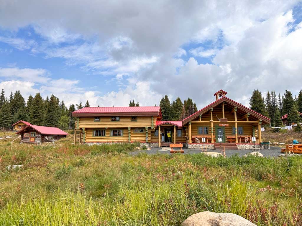
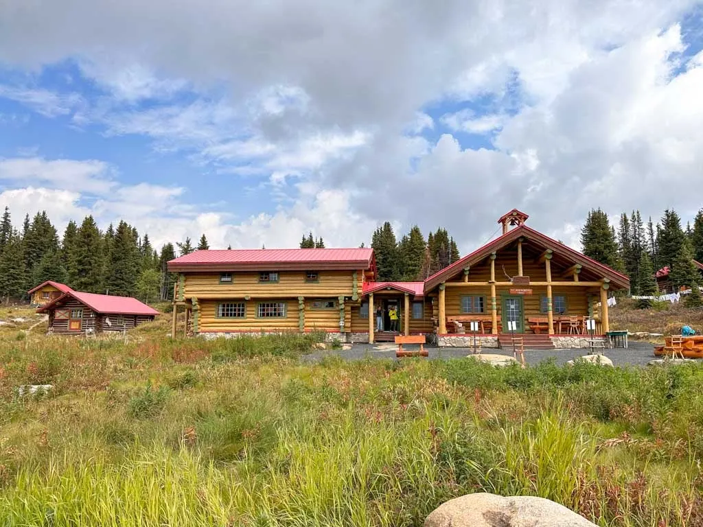
Assiniboine Lodge
Built in 1928, this rustic backcountry lodge offers accommodation both in lodge rooms and stand-alone cabins. Stays at the lodge include all meals and guided hikes every day. Rates range from $440-$645 plus tax per person per night.
You can hike into the lodge or pay for a helicopter in. But no matter how you arrive, your stay must match up with the helicopter schedule. This means arriving or departing on a Sunday, Wednesday, Friday or holiday Monday.
Bookings for the lodge are very popular. You must submit a request form in August of each year to get a spot for the following year. However, they do have a waitlist in case of cancellations.

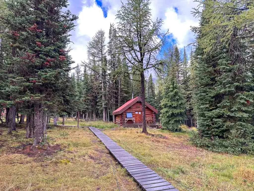
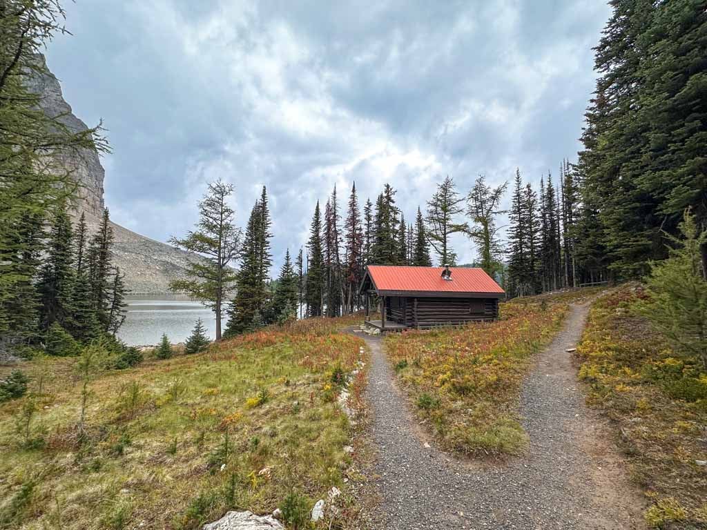
Naiset Huts
The Naiset Huts are a cluster of five backcountry huts owned by BC Parks but operated by Assiniboine Lodge. Each log hut sleeps 5-8 people (depending on the size of the hut) on basic wooden bunks. Hut guests must use the nearby Wonder Lodge cooking shelter to eat and prepare meals.
You have to book the whole hut. And just like with the Assiniboine Lodge, your stay must match up with the helicopter schedule. (So you have to arrive/depart on a Sunday, Wednesday or Friday.) Rates range from $150-$240 per hut per night.
Bookings for the Naiset huts are by phone or online via the lodge and open in early January each year for the following summer. The entire summer books up right away. There is no waitlist. Reservations for 2026 open on January 13, 2025 at 8:30 am Mountain Time. Booking is by phone 403-678-2883.

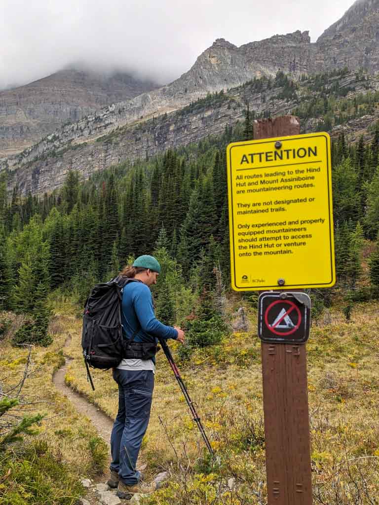
Hind Hut
The Hind Hut is a rustic backcountry hut for climbers attempting to scale Mount Assiniboine. You will need mountaineering equipment and glacier travel skills to reach it. This is not a hut for hikers. You can reserve the Hind Hut through Mount Assiniboine Lodge.

Camping
Between the core area and the approach trails, there are 14 campgrounds and rustic shelters you need to know about at Mount Assiniboine. I’ve got details on each one below.
| Camp | Park | Reservations? | Location | Distance from Lake Magog |
|---|---|---|---|---|
| Lake Magog | BC Parks | Yes | Core | 0 km |
| O’Brien Meadows (Group Site) | BC Parks | Yes | Core/Assiniboine Pass Route | 3.3 km |
| Mitchell Meadows | BC Parks | No | Core/Simpson River Route | 5.7 km |
| Og Lake | BC Parks | Yes | Core/Sunshine Route | 6.6 km |
| Allenby Junction (Br17) | Parks Canada | Yes | Assiniboine Pass Route | 9 km |
| McBride’s Camp (Br14) | Parks Canada | Yes | Assiniboine Pass or Wonder Pass Routes | 12.1 km |
| Bryant Creek Shelter (Closed) | Parks Canada | Closed | Assiniboine Pass or Wonder Pass Routes | 12.5 km |
| Marvel Lake (Br13) | Parks Canada | Yes | Assiniboine Pass or Wonder Pass Routes | 13.8 km |
| Big Springs (Br9) | Parks Canada | Yes | Assiniboine Pass or Wonder Pass Routes | 16.5 km |
| Porcupine | BC Parks | Yes | Sunshine Route | 14.8 km |
| Police Meadows Shelter | BC Parks | No | Sunshine Route | 18.3 km |
| Howard Douglas (Su8) | Parks Canada | Yes | Sunshine Route | 21.9 km |
| Rock Lake | BC Parks | No | Simpson River Route | 13.8 km |
| Surprise Creek | BC Parks | No | Simpson River Route | 20.9 km |
| Mitchell River Shelter | BC Parks | No | Mitchell River Route | 10.9 km |
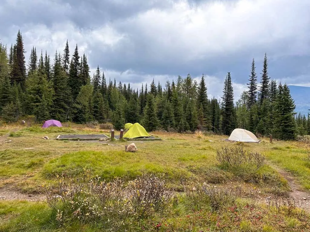
Lake Magog Campground
Location: Core Area
Reservations Required? Yes – book through BC Parks
Fees: $10/person/night + $6/tent pad/night reservation fee
Best For: Using as a base camp for day hikes in the core area.
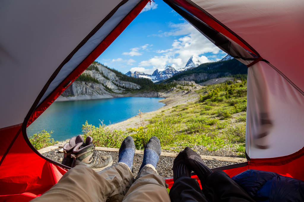
Lake Magog Campground is the most popular campground at Mount Assiniboine. Most hikers plan to base themselves here for a couple nights to enjoy the scenery at Lake Magog and go on day hikes.
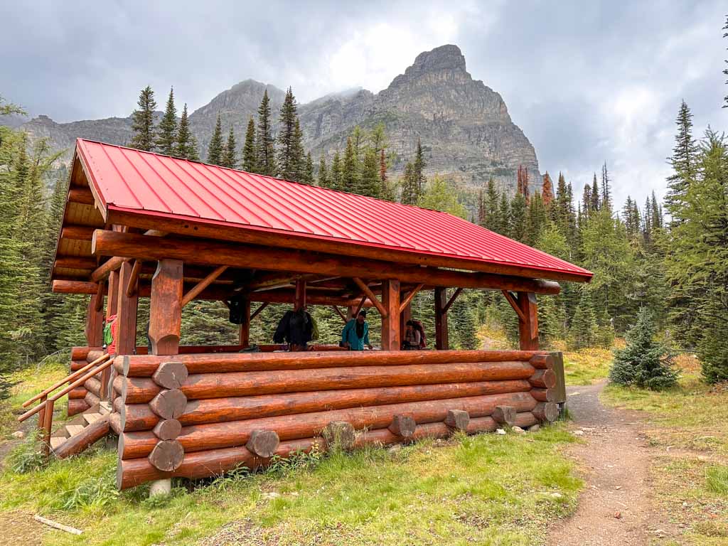
The campground has 40 dirt and gravel tent pads (though some are prone to flooding during heavy rain). The campground has outhouses, food lockers, and food hanging poles. There are also two covered cooking shelters with greywater disposal pits.
There are also non-potable water taps next to the cooking shelters, but you still have to treat your water. Late in the season, the taps may be off either because the water supply has run dry or because the pipes are frozen. In that case, you can get water from the stream on the east side of the campground or from the lake. The taps were off when I stayed here, but we were able to use the creek, which was a 5-minute walk from the cooking shelters.

The campsites are mostly in the trees (although some are in small meadows), but there aren’t really any great views. However, the trees do help if you want to put a tarp up – some of the meadow campsites get pretty soggy when it rains heavily or when it snows and then melts.

The campground is huge with lots of little trails connecting the tent pads and cooking shelters. It can be a bit confusing to wander around in but the map at the campground entrance does help.
On my trip, we stayed at Lake Magog for three nights. It was a great base for day hikes. And it was so nice to have the covered cooking area since we had a lot of rain and slushy snow.
O’Brien Meadows Group and Horse Campgrounds
Location: Core Area/Assiniboine Pass Route – 3.3 km from Lake Magog Camp
Reservations Required? Yes – book through Assiniboine Lodge
Fees: Inquire with Assiniboine Lodge for details.
Best For: Groups of 15 people or more OR horseback riders
These two campgrounds are located just west of Assiniboine Pass on the way to Assiniboine Lodge. You must have at least 15 people in your group to book the group site. And you must be on horseback and have a letter of permission from BC Parks to reserve the Horse Camp. Bookings are through Assiniboine Lodge.
Mitchell Meadows Campground
Location: Core/Simpson River Route – 5.7 km from Lake Magog Camp
Reservations Required? No – all sites are first-come, first-served
Fees: Free
Best For: Staying close to the core area without a reservation
The Mitchell Meadows campground is pretty under the radar even though it is just 5.7 km from Lake Magog Campground and doesn’t require reservations. However, it is a very basic campground with only two dirt tent pads, an outhouse and a food locker.
It’s a great location for day hikes to Elizabeth, Cerulean, Sunburst and Magog Lakes. It’s also very convenient if you want to hike to the Nubet and Nub Peak. The only disadvantage is that if you hike in from Assiniboine Pass, Wonder Pass, or Sunshine, you will have to hike through Lake Magog Campground to get here.
Og Lake Campground
Location: Core/Sunshine Route – 6.6 km from Lake Magog Camp
Reservations Required? Yes – book through BC Parks
Fees: $10/person/night + $6/tent pad/night reservation fee
Best For: Views and if you’re hiking in from Sunshine.
Og Lake Campground has great views of Mount Assiniboine peaking out from behind a ridge. It’s really the only campground with views since it is set in beautiful meadows. This popular campground has 10 dirt tent pads, an outhouse, food lockers, and a cooking area. It’s 6.6 km from Og Lake to Lake Magog, so it’s an ok basecamp for day hikes in the Lake Magog core area.

Allenby Junction (Br17), McBride’s (Br14), Marvel Lake (Br13), and Big Springs (Br9) Campgrounds and Bryant Creek Shelter
Location: Assiniboine Pass/Wonder Pass Route – 9 km, 12.1 km, 13.8 km, and 16.5 km from Lake Magog Camp
Reservations Required? Yes – book through Parks Canada
Fees: $13.50/person/night + $11.50 flat-fee reservation fee per booking
Best For: Breaking up the journey into the Core Area along the Assiniboine Pass or Wonder Pass Routes
These four forested campgrounds are located along Bryant Creek on the way to Assiniboine Pass and Wonder Pass. They all have pit toilets, cooking areas, and food lockers.
I’ve included the “Br” numbers with each campsite, as that’s the Parks Canada code for them that you will see on Park signs and when making a reservation. The “Br” part is for Bryant Creek because that’s the section of the park they are in.
Marvel Lake (Br13) and McBride’s (Br14) are the most popular since they are roughly at the halfway point (12.1/13.8 km from Lake Magog). They each have 10 tent sites. Marvel is technically on the Wonder Pass Route and McBride’s is technically on the Assiniboine Pass, but both are just a few hundred meters from the junction, so it’s easy to stay at both camps on either route. It’s also worth noting that Marvel isn’t actually on the lake.
I stayed at McBride’s on my hike out. Since all the tent sites are in the forest, it was pretty dark and cold, but the cooking area did get a bit of sun.
Big Springs (Br9) (5 tent sites) isn’t as busy since it is too early in the hike (16.5 km from Magog), but it’s before the Wonder Pass and Assiniboine Pass routes split

Allenby Junction (Br17) (5 tent sites) is the closest to Lake Magog (9 km away) so camping here will give you more time at Magog the following day. Staying here is only feasible if you are hiking the Assiniboine Pass Route.
The Bryant Creek Shelter sleeps 12 people and has an outhouse and food lockers. However, it has been closed for redevelopment for several years and has no announced reopening date.

Porcupine Campground
Location: Sunshine/Citadel Pass Route – 14.8 km from Lake Magog
Reservations Required? Yes – book through BC Parks
Fees: $10/person/night + $6/tent pad/night reservation fee
Best For: Breaking up the journey into the Core Area on the Sunshine/Citadel Pass Route
The Porcupine campground is located down a very steep side trail in the forested Golden Valley at roughly the halfway point between Sunshine Village and Lake Magog, so it’s a popular place to camp. The side trail to the campground is 1 km long and drops 225 meters. You can climb back up to resume your hike or follow another trail southeast through the valley bottom to meet back up with the main trail 3 km from camp
Porcupine Campground has 10 tent sites, an outhouse, a cooking area with picnic tables and food lockers.
Police Meadows Shelter
Location: Sunshine/Citadel Pass Route – 18.3 km from Lake Magog
Reservations Required? No – all sites are first-come, first-served
Fees: Free
Best For: Breaking up the journey into the Core Area on the Sunshine/Citadel Pass Route
To get to the Police Meadows Shelter, you hike to Porcupine Camp, then continue southeast. A few minutes later, turn right onto the trail to Police Meadows and immediately ford the creek. It’s about 3.5 km from the main trail to Police Meadows. The swampy trail is not maintained and can be hard to find in places. The Shelter is very rustic (and reportedly full of mice).
Police Meadows Shelter sleeps 6 on basic wooden bunks and has a woodstove, outhouse, and food lockers. Note that the cabin is closed from Oct 1 to 31 each year because it is leased to a hunting guide.
Howard Douglas Campground (Su8)
Location: Sunshine/Citadel Pass Route – 21.9 km from Lake Magog
Reservations Required? Yes – book through Parks Canada
Best For: Breaking up the journey into the Core Area on the Sunshine/Citadel Pass Route
Fees: $13.50/person/night + $11.50 flat-fee reservation fee per booking
This campground is near Howard Douglas Lake on the Sunshine/Citadel Pass Route. It has five tent pads, an outhouse and food lockers. Since it is only 5.5 km from the top of the Sunshine Gondola, it is too early in the journey to stop for most hikers.
Note: The “Su8” in the name is the Parks Canada code for this campground. The “Su” is because you can access this campground from Sunshine Village.
Rock Lake and Surprise Creek Campgrounds
Location: Simpson River Route – 13.8 and 20.9 km from Lake Magog
Reservations Required? No – all sites are first-come, first-served
Fees: Free
Best For: Breaking up the journey into the Core Area on the Simpson River Route
These two campgrounds are on the less popular Simpson River Route. They both have outhouses and food lockers.
Rock Lake has 3 tent sites and a cooking area. Since it is set against the sheer sides of Indian Peak, Rock Lake is gorgeous.
Surprise Creek technically doesn’t have any designated tent sites, but apparently, there are places to pitch a tent. Surprise Creek also has a rustic cabin that sleeps 6-8 on wooden bunks and has a woodstove.
Mitchell River Shelter
Location: Mitchell River Route – 10.9 km from Lake Magog
Reservations Required? No – all bunks are first-come, first-served
Fees: Free
Best For: Breaking up the journey into the Core Area on the Mitchell River Route
The Mitchell River Shelter is located on the seldom-used Mitchell River Route. BC Parks says it is extremely rustic and sleeps 6-8. It has a wood stove and a nearby outhouse. I haven’t been able to find any trip reports from anyone who has been to this shelter, so I don’t have much other info on it.
Day Hikes in the Mount Assiniboine Core Area
You will want to spend at least one or two days at Lake Magog to do some day hikes. Here are the main options:
The Niblet, The Nublet, and Nub Peak
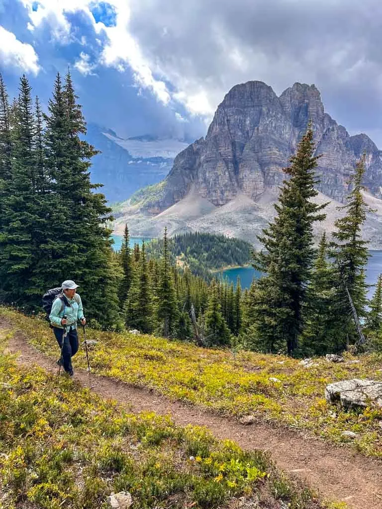
This is the most popular hike at Assiniboine since it has great views of Mount Assiniboine, Sunburst Peak and the surrounding lakes. The Niblet and Nublet are subpeaks along the Nub Peak Ridge and all have great views.
I hiked up to the Nublet twice to try to get different views since the clouds kept moving in and out. I didn’t end up going all the way to Nub Peak since it started to rain and the wind was insane, but some of my friends summited while I was doing a different hike.
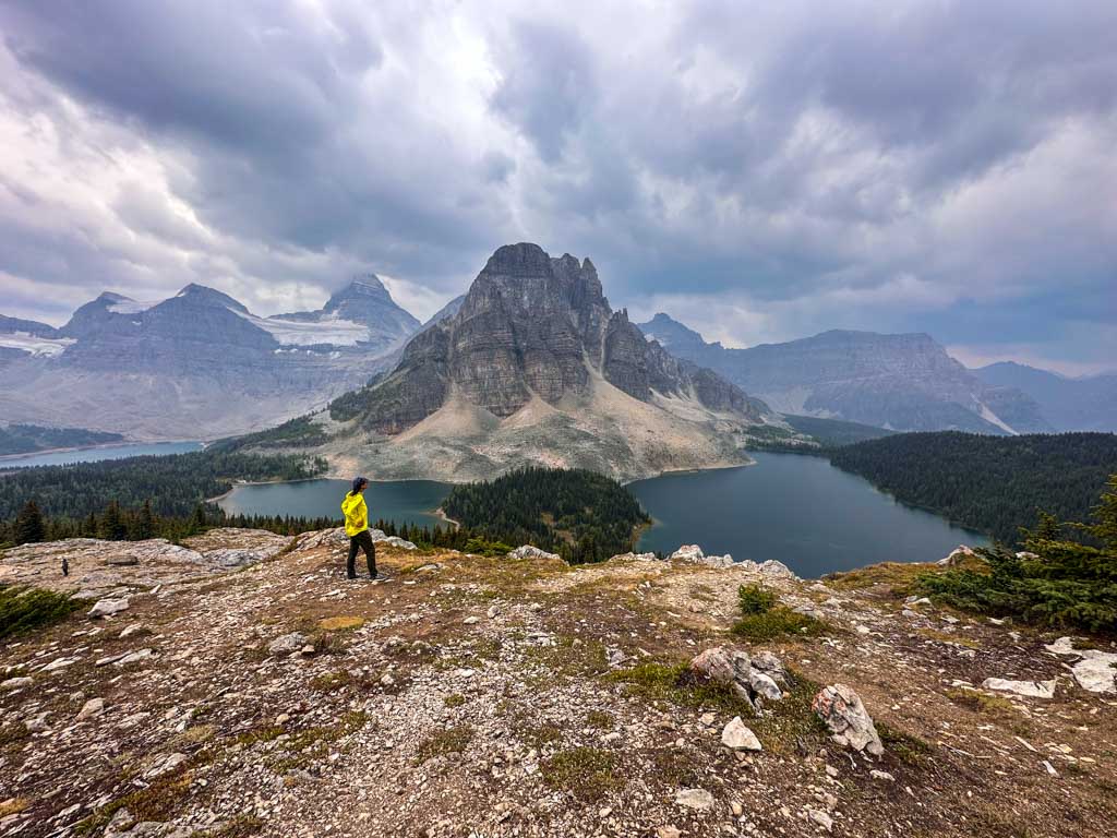

There are three ways to get to this hike. The first is via a trail from the Lodge that goes up to the Niblet, then continues up the ridge to the Nublet and Nub Peak. The other ways go to Sunburst Lake first. From, there, you can go east and connect with the trail coming from the lodge and go up the Nublet. Or you can continue past Cerulean Lake, and then take a trail that climbs the ridge to meet up with the trail to the Nublet and Nub Peak just above the Niblet.
From Lake Magog Camp, the most direct route (via Cerulean Lake) to the Niblet is 7 km return with 200 m of elevation gain, the Nublet is 8.5 km return with 330 m of gain, and Nub Peak is 11.2 km return with 635 m of gain. Some people may find the route to Nub Peak exposed and a bit scrambly.
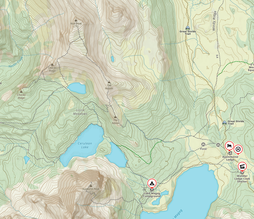
Sunburst, Cerulean, and Elizabeth Lakes
This pretty trio of lakes sits northwest of Lake Magog. Sunburst and Cerulean have great views of Sunburst Peak. And from Elizabeth, you can look up to the ridge connecting the Nublet and Nub Peak. A short trail runs between all three lakes. I enjoyed this nice easy walk, even in the rain.


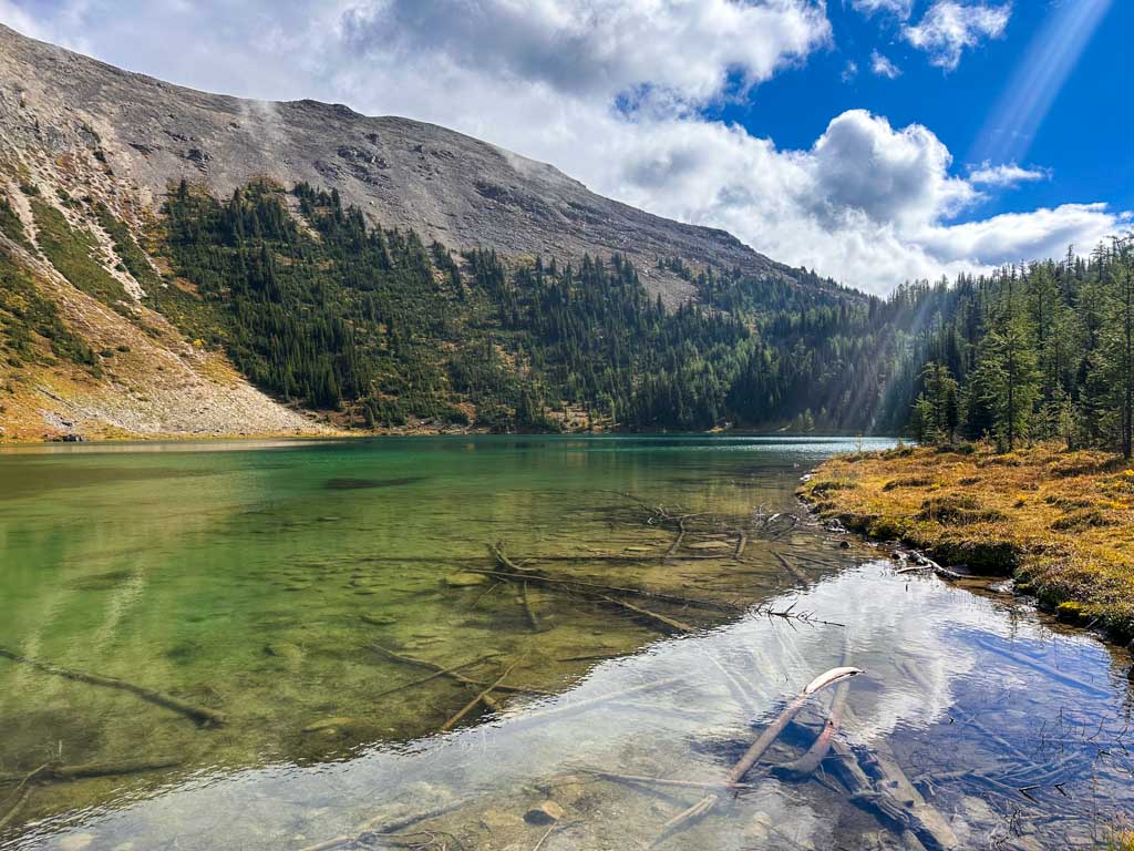

It’s 1.5 km return with 50 m elevation gain to Sunburst Lake, 3 km return with 60 elevation gain to Cerulean Lake and 5 km return with 140 elevation gain to Elizabeth Lake from Lake Magog Campground. You can also connect the trail to the lakes with a hike to the Nublet or explore further towards Mitchell Meadows.
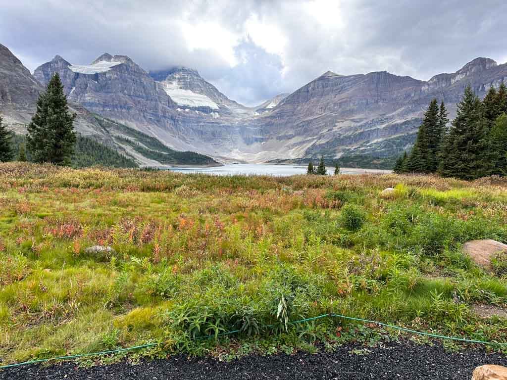
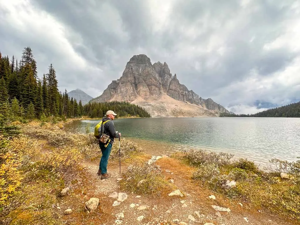
Lake Magog
Take some time to wander along the shoreline of Lake Magog. The main access to the lakeshores is in front of the lodge. From here, you get great views of Mount Assiniboine across the lake. You can also access the lake from the back of the campground. A rough trail parallels the creek down to the shore.
If you want to explore further, it’s possible to circumnavigate the lake on a series of informal paths through the gravel. I walked around the lake one afternoon on my trip. It was interesting to see the views from a different angle. But a rainstorm blew in when we were halfway around!

Assiniboine Lodge for Afternoon Tea
It’s worth making the short 2 km hike to Assiniboine Lodge from the campground for afternoon tea. The front porch of the lodge is open for hikers on Mondays, Tuesdays, Thursdays, and Saturdays (plus Sundays on long weekends) from 4 to 5 pm. They serve tea, cake, beer and wine. Bring cash and go early to get a good spot to sit.
On my trip, we were so excited to go for tea, but it was cancelled at the last minute since some people in the Naiset Huts were sick with a gastro virus and the Park Ranger and Lodge staff were concerned it would spread.
Wonder Pass
If you don’t plan to hike in or out of the core area via Wonder Pass, plan to day hike there instead. The route travels through pretty meadows and passes Gog Lake. The highlight is the incredible view from the pass. The larch trees here are also spectacular in fall.
From Lake Magog Campground, it’s a 4.4 km hike to the pass with 185 of elevation gain. You can descend the pass for about half a kilometre then take an unmarked side trail to the left for a further 1.2 km each way to a great viewpoint over Marvel Lake.
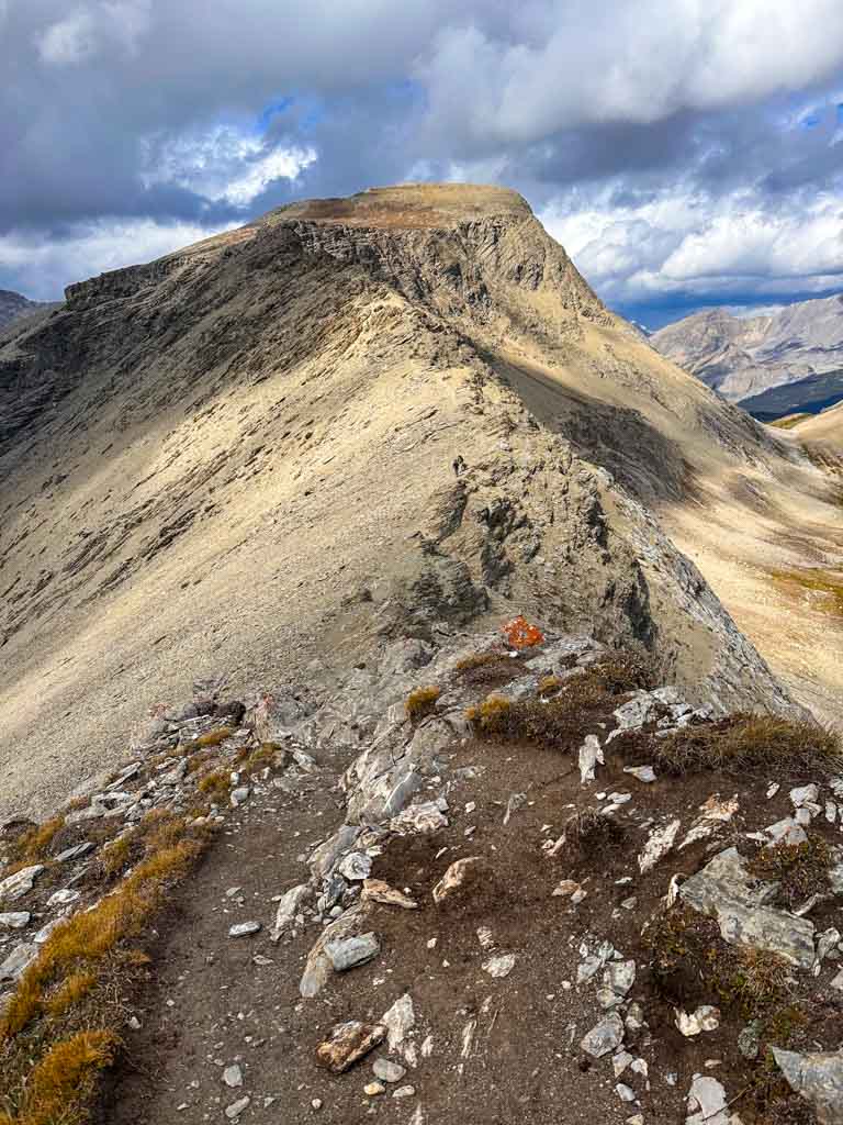
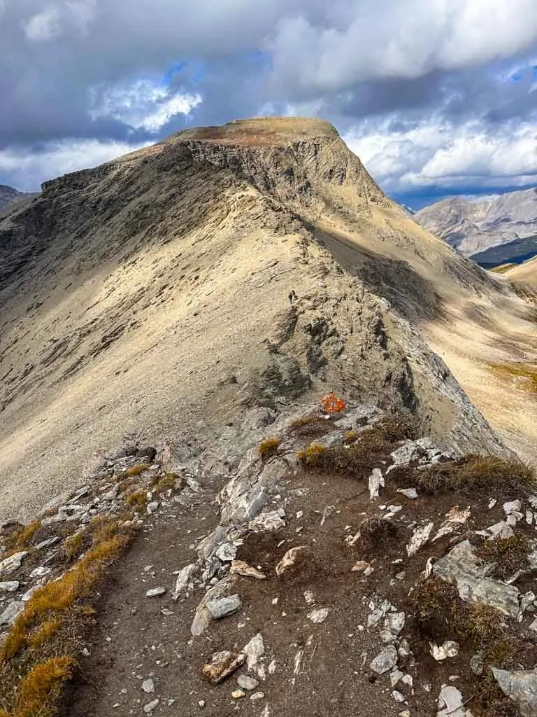
Windy Ridge
This hike heads through the meadows to a beautiful viewpoint at the top of Windy Ridge, which is on the shoulder of Og Mountain. You’ll top out at 2675 m, which is one of the highest points in the area. From here, you can look down to Og Pass, north to Haflway Lodge in the Brewster Creek Valley and back towards Mount Assiniboine. Depending on the season, the wildflowers or larches may be putting on a show.
The hike is 14.5 km round-trip from Lake Magog Campground with 675 of elevation gain. The final section is a bit scrambly and exposed.
Have questions about Mount Assiniboine? Join the Mount Assiniboine Facebook Group to connect with other hikers!
Mount Assiniboine Itineraries
There are tons of different ways to set up a trip to Assiniboine. With six ways to get to the core area and 17 places to stay (campgrounds, shelters, huts, and a lodge) the possibilities are almost endless. I’ve got a few sample itineraries below that I recommend.
Here are my tips to keep in mind when designing an itinerary:
- Plan to spend at least 1.5 to 2 days in the Lake Magog area to do day hikes.
- If possible, book the Lake Magog campground. My itineraries below also work if you’re staying at the Lodge or Naiset Huts.
- Strong hikers can make it to Lake Magog from the Mount Shark or Sunshine Trailheads or from Magog back out to the trailheads in one long day. However, you will be on the trail all day and should plan to start very early.
- To make the hike in or out easier, consider paying to send your luggage by helicopter for $5/pound on Wednesdays, Fridays, and Sundays. However, at that price, it’s almost worth it to just fly yourself and get an extra day of hiking in the core area.
- Booking sites in both Banff National Park and Mount Assiniboine Provincial Park can be tricky. (See the Reservations section above for more info). Make a back up itinerary in case you don’t get the sites you want.
Assiniboine Pass-Wonder Pass Loop
This is the classic way to hike to and from the Assiniboine core area. Start by going up Assiniboine Pass and go down Wonder Pass to enjoy the views on your way out. Strong hikers could cut this down to 4 or 5 days by hiking in or out in one day.
Day 1: Hike from Mount Shark Trailhead to Marvel Lake/McBride’s/Allenby Junction Camps (12.8 km/13.4 km/16.5 km with 266 m/319 m/351 m of elevation gain)
Day 2: Marvel Lake/McBride’s/Allenby Junction Camps to Lake Magog Camp over Assiniboine Pass (13.8 km/12.2 km/9 km with 530 m/451 m/417 m of elevation gain)
Day 3: Day hikes from Lake Magog Camp
Day 4: Day hikes from Lake Magog Camp
Day 5: Hike from Lake Magog Camp to Marvel Lake/McBride’s/Big Springs Camps via Wonder Pass (13.8 km/13.5 km/17.6 km with 365 m of elevation gain)
Day 6: Hike from Marvel Lake/McBride’s/Big Springs Camps to Mount Shark Trailhead (12.9 km/13.3 km/9 km with 200 m of elevation gain)

Out-and-Back From Sunshine
Most hikers agree that the route from Sunshine is the most scenic way to get to Assiniboine. While the route has lots of ups and downs, you gain most of the elevation in the gondola. Keep an eye on the gondola schedule, especially on the way back.
Day 1: Hike from the top of the Sunshine Gondola to Howard Douglas/Porcupine Camp/Og Lake Camps (5.6 km/13.3 km/20.7 km with 257 m/427 m/801 m of elevation gain)
Day 2: Hike from Howard Douglas/Porcupine/Og Lake Camps to Lake Magog Camp (21.7 km/14.8 km/6.7 km with 690 m/589 m/150 m of elevation gain)
Day 3: Day hikes from Lake Magog Camp
Day 4: Day hikes from Lake Magog Camp
Day 5: Hike from Magog Camp to Og Lake/Porcupine/Howard Douglas Camps (6.7 km/14.7 km/22.3 km with 26 m/195 m/843 m elevation gain)
Day 6: From from Og Lake/Porcupine/Howard Douglas Camps to the top of the Sunshine Gondola (20.7 km/13.3 km/5.6 km with 934 m/832 m182 m of elevation gain)
Traverse from Sunshine to Mount Shark via Wonder Pass
If you can figure out transportation between the trailheads, this itinerary gets you all the best scenery. Staring at Sunshine is a bit easier since there is less elevation gain at the start. For an easier version of this itinerary that includes a helicopter ride, see below. This is my dream itinerary and I want to find a way to make it happen for my next trip to Assiniboine.
Day 1: Hike from the top of the Sunshine Gondola to Howard Douglas/Porcupine Camp/Og Lake Camps (5.6 km/13.3 km/20.7 km with 257 m/427 m/801 m of elevation gain)
Day 2: Hike from Howard Douglas/Porcupine/Og Camps to Lake Magog Camp (21.7 km/14.8 km/6.7 km with 690 m/589 m/150 m of elevation gain)
Day 3: Day hikes from Lake Magog Camp
Day 4: Day hikes from Lake Magog Camp
Day 5: Hike from Lake Magog Camp to Marvel Lake/McBride’s/Big Springs Camps via Wonder Pass (13.8 km/13.5 km/17.6 km with 365 m of elevation gain)
Day 6: Hike from Marvel Lake/McBride’s/Big Springs Camps to Mount Shark Trailhead (12.9 km/13.3 km/9 km with 200 m of elevation gain)
Traverse from Assiniboine to Sunshine with Helicopter to Start
To make the shuttle logistics easier, you can also do the traverse itinerary in reverse and start with a helicopter. You would fly in to Assiniboine from Canmore (skipping two days of hiking), take the shuttle from Sunshine to Banff, and then the bus back to Canmore.
Day 1: Fly from Canmore or Mount Shark Helipad to Assiniboine, and then hike to Lake Magog Camp (2 km with 22 m of elevation gain). Day hikes from Lake Magog Camp.
Day 2: Day hikes from Lake Magog Camp
Day 3: Hike from Magog Camp to Og Lake/Porcupine/Howard Douglas Camps (6.7 km/14.7 km/22.3 km with 26 m/195 m/843 m elevation gain)
Day 4: From from Og Lake/Porcupine/Howard Douglas Camps to the top of the Sunshine Gondola (20.7 km/13.3 km/5.6 km with 934 m/832 m/182 m of elevation gain)
Helicopter In, Wonder Pass Out
This itinerary is great if you are tight on time, have the budget for a helicopter ride, and still want to see lots of incredible scenery. Keep in mind that the Mount Shark Helipad is 1.5 km and 70 m past the Mount Shark Trailhead – the Day 4 stats reflect that. This is the itinerary that I used (with a stop at McBride’s Camp on the way out), except that we added an extra day at Lake Magog for 5 days total.
Day 1: Fly into Assiniboine from Mount Shark Helipad, and then hike to Lake Magog Camp (2 km with 22 m of elevation gain). Day hikes from Lake Magog Camp.
Day 2: Day hikes from Lake Magog Camp
Day 3: Hike from Lake Magog Camp to Marvel Lake/McBride’s/Big Springs Camps via Wonder Pass (13.8 km/13.5 km/17.6 km with 365 m of elevation gain)
Day 4: Hike from Marvel Lake/McBride’s/Big Springs Camps to Mount Shark Helipad (14.4 km/14.8 km/11.5 km with 270 m of elevation gain)

Og Lake Base Camp From Sunshine
If you can’t get a reservation at Lake Magog, this itinerary still lets you see some of the area highlights. From Og Lake, you can day hike to Lake Magog, Nub Peak, Wonder Pass or Windy Ridge (but keep in mind that these will be long days.)
Day 1: Hike from the top of the Sunshine Gondola to Og Lake Camp (20.7 km with 801 m of elevation gain)
Day 2: Day hikes from Og Lake
Day 3: Day hikes from Og Lake
Day 4: Hike from Og Lake Camp to the top of the Sunshine Gondola (20.7 km with 934 m of elevation gain)
Out-and-Back via Simpson River
If you want an off-the-beaten-path itinerary, this one is for you. It uses trails in the quiet western side of the park but still lets you visit the core area. And best of all, it requires no reservations.
Day 1: Hike from the Simpson River trailhead to Surprise Creek/Rock Lake Camps (11.4 km/18.5 km with 170 m/735 m of elevation gain)
Day 2: Hike from Surprise Creek/Rock Lake Camps to Mitchell Meadows Camp (14.7 km/8 km with 958/371 m of elevation gain)
Day 3: Day hikes from Mitchell Meadows Camp
Day 4: Day hikes from Mitchell Meadows Camp
Day 5: Hike from Mitchell Meadows Camp to Rock Lake/Surprise Creek Camps (8 km/14.7 km with 354 m/377 m of elevation gain)
Day 6: Hike to Simpson River trailhead from Rock Lake/Surprise Creek Camps (18.5 km/11.4 km with no elevation gain)
Mount Assiniboine Hiking Tips
Park Rangers: The park rangers come through the Magog campground around 6 pm each evening to check permits and answer camper questions. The rangers can also help you make helicopter arrangements. The rangers are not available at other times and hikers are not allowed to ask questions at the lodge except at tea time.
Tea the Lodge: Don’t miss afternoon tea at the Assiniboine Lodge on Mondays, Tuesdays, Thursdays and Saturdays from 4 to 5 pm. Bring cash to buy tea, cake, beer and wine from the lodge’s front porch. They don’t let hikers come inside.
Helicopters: Consider flying in or out of Assiniboine to save more time for hikes in the core area. Or pay to have your luggage flown in or out to make your hike easier. If you didn’t pre-book, once you get to Assiniboine, you can ask at the Lodge at tea time or talk to the ranger at Lake Magog to arrange flights out or to fly your luggage out.

Bears: This is black and grizzly bear country. Bring bear spray, make noise as you hike, and store your food securely. See my bear safety tips for more info. I didn’t see any bears on my trip, but other campers told us they saw a big grizzly just outside the campground one evening and at Wonder Pass another afternoon.
Bugs: In July and early August the mosquitos can be bad, especially at some of the campgrounds since they are near water. Bring repellent and/or a head net.
Photography: Mount Assiniboine is a popular spot for photographers. The “money shot” is Sunburst Peak and Mount Assiniboine from the Niblet, Nublet or Nub Peak. Many people hike to Nub Peak several times to catch the mountains in different lights, especially at sunrise and sunset. Or to find a moment when Mount Assiniboine is not covered by clouds. Other good photography locations include Sunburst Lake, Gog Lake, Og Lake, and Wonder Pass. But keep in mind that the weather often does not cooperate!
Changeable weather: The high mountains are notorious for fickle weather. Rainstorms and even snow can blow in at any time – I had tons of bad weather on my trip, unfortunately. Bring lots of warm clothing, a warm sleeping bag, and waterproof rain gear and a good tent. My guide to the best weather apps for hikers has some great weather tips. And read my tips for staying warm in a tent – it gets cold up there!

Horses: While this area was traditionally popular with horseback riders and you will see signs in the park about horse routes, horses are no longer common. Equestrians need a letter of permission from BC Parks to ride in the park.
Trail Conditions: Rangers post trail conditions reports online for Mount Assiniboine Provincial Park (scroll down to the Special Notes section) and Banff National Park
Cell Service/Wi-fi: There is no cell service anywhere in the park or on the hike into the park. The lodge does not have wi-fi. You will lose service soon after leaving Banff or Canmore. Be sure to download offline maps on your phone before you arrive. (I recommend using All Trails+ or Gaia GPS app.)

Now you have all the info you need to plan a hiking trip to Mount Assiniboine Provincial Park. I’m already dreaming of heading back here – probably to hike in via Sunshine. If you have questions or there’s anything I’m missing in this guide, ask in the comments I’d love to help.
READ NEXT:
- Join the Mount Assiniboine Facebook group to ask questions and connect with other hikers
- 11 Best Backpacking Trips in the Canadian Rockies
- Hiking at Sunshine Meadows in Banff – Is it Worth It?
- 31 Best Backpacking Trips in BC
- Backpacking Checklist: Gear You Need To Go Backpacking
- 20+ Ways to Reduce Your Backpack Weight
- How to Stay Warm in a Tent: Over 40 Tips
- Bear Safety for Hikers, Campers and Backpackers


- Best Sun Hoodies for Hiking - June 3, 2026
- Lower Stein Valley Trail Hiking and Backpacking Guide - May 27, 2026
- The Best Things to Do in Vernon, BC - May 21, 2026
Anne
Thursday 9th of April 2026
Wonderful guide! Helped a lot. I was wondering if you could give advice to me as a solo female traveler? Is it doable to do alone? At the campgrounds there are other people so it's mostly the hike in to magog campground. I have hiked alone before, with elevation gain too (peaks of the balkan trail). Just didn't camp but stayed at guesthouses. I am mostly worried about the bear part on the trail. Wondering if I can attempt it alone or should find people to join. 🙏🏻
Taryn Eyton
Thursday 9th of April 2026
It is a popular campground and the trails around the campground and in the core area often have lots of people. However, the area is remote and with several options for approach hikes into the area, you can sometimes go hours without seeing another person. The area is known for grizzly bears (although there are rarely negative interactions with people). Parks Canada recommends hiking in groups in grizzly bear habitat. If you aren't experienced hiking in bear habitat, I would recommend going with a group.
Emily
Saturday 20th of July 2024
Wow, this is an awesome resource. I was so lost when trying to find the best places to camp/routes, and this highlights exactly why, since there are soooo many different ways to get here. Thanks for putting the time and energy into making such a detailed post.
Andy Gibb
Wednesday 24th of January 2024
This is a great resource, Taryn, and clearly took a ton of time to pull together! Even though I've been there, I can see myself referring to it for our next visit, so thank you!
I fully endorse hiking out via Wonder Pass rather than in - the views of Marvel Lake are stunning. Sure, Assiniboine Pass is less scenic, but it's definitely easier and we saw only one other group on that route (in September) beyond Bryant Shelter.
We stayed at Allenby Junction on our last visit and the tent sites were, well, rustic (that's a generous description). It's clearly not very popular but it was a great place to feel very small and isolated! We had something chew our tent while we were there - our best guess is a porcupine, but we never saw or heard it.
We also didn't see bears (only prints in the mud) but other people did. We heard elk and coyotes though.
It might be worth highlighting that Og Lake has no shelter - at all, not even trees - so you're totally exposed to the elements (as we found out in the pouring rain!). But the view of Assiniboine is awesome.
Yeah, we also want to do the traverse, but we've promised ourselves a helicopter ride next time as I think we've earned it, having hiked in from both ends :-) There's an even longer traverse suggested by the Copelands that I'd also love to try some day...