
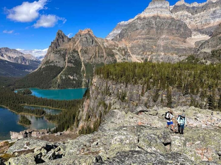

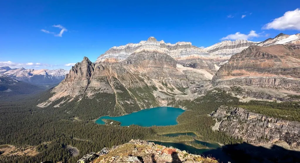
I’ve hiked a lot of trails in the Canadian Rockies, and Lake O’Hara has by far the best scenery: brilliant blue lakes, towering peaks, and icy glaciers. And if you are going to visit Lake O’Hara, you have to hike the Alpine Circuit.
The Lake O’Hara Alpine Circuit is an 11-kilometre-long loop hike that circles Lake O’Hara on a series of airy ledges high above the lake. The route is actually made up of three trails: Wiwaxy Gap/Huber Ledges, Yukness Ledges, and All Soul’s Route.
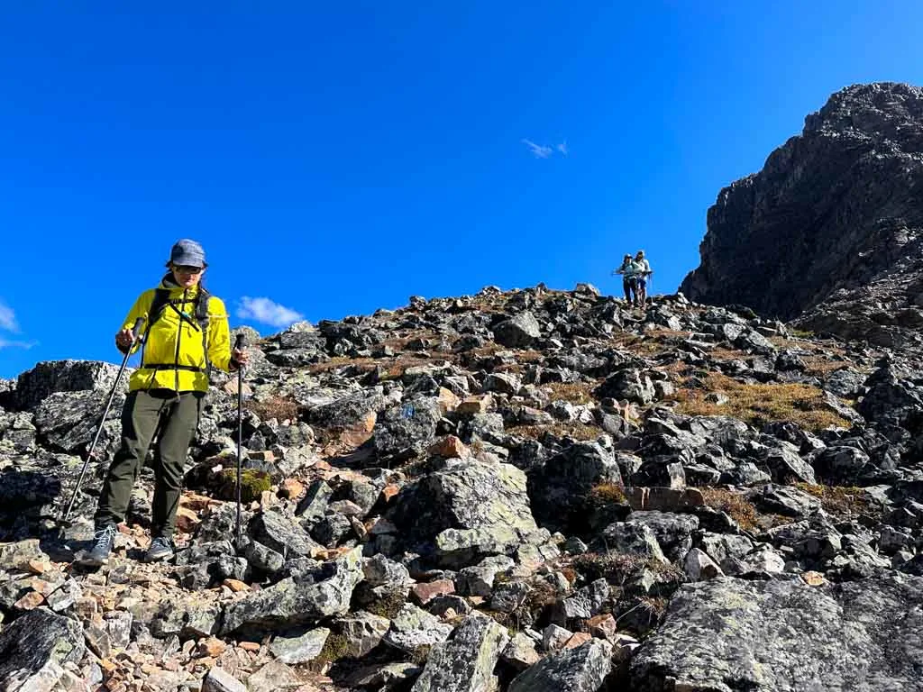
Since this trail has some steep drops, it can seem a bit intimidating. I’ve hiked the ledge routes above Lake O’Hara twice (and I’m a hiking guidebook author) so I’ve got all the info you need to know to decide if this hike is right for you. (Spoiler: Most hikers agree that it isn’t as scary as it looks and the views are worth it.)
This guide to the Lake O’Hara Alpine Circuit includes:
- Quick info and trail stats for the Lake O’Hara Alpine Circuit hike including distance, duration, difficulty, best time to go, and lots more
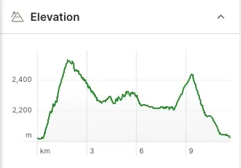
- A Lake O’Hara map and elevation profile that shows key points
- How to get to Lake O’Hara: Info on driving directions to the parking lot, the shuttle bus, and walking up the access road.
- Key distances on the Alpine Circuit with kilometre markers and elevation
- Alpine Circuit Hiking Directions: Step-by-step directions for the Wiwaxy Gap/Huber Ledges, Yukness Ledges, and All Soul’s Route sections plus my recommended detour to Opabin Prospect
- Variations for the Alpine Circuit Hike: Side trails to add on or ways to make it shorter but still get great views.
- Lake O’Hara Hiking Tips: My advice for what to bring, how to prepare, and what you need to know
PS: If you want more info about Lake O’Hara including how to make reservations, where to stay, and other trails in the area, check out my full Lake O’Hara guide.
This is a sensitive wilderness area. Learn how to Leave No Trace to keep the wilderness wild. Make sure you are prepared by bringing the 10 Essentials. Get ready for adventure with this checklist of things to do before every hike.
Hey there: Some of the links in this post are affiliate links, which means I earn a small commission at no cost to you. Thanks for your support. -Taryn

Quick Info and Trail Stats:
Here are the basic stats that you need to know about hiking the Lake O’Hara Alpine Circuit:
Duration: 4.5-8.5 hours
Distance: 11 km/6.8 mi (but my recommended route below adds an extra 0.7 km to visit an incredible viewpoint)
Difficulty: Challenging
Elevation Gain: 1,056 m/3,494 ft
Best Time to Go: July to late September
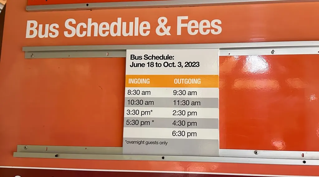
Permits and Fees: You must pay National Park entry fees ($11/person/day or $22/car/day). Reservations and fees ($25.50/person) required for the optional shuttle bus. (See the Getting There section below.)
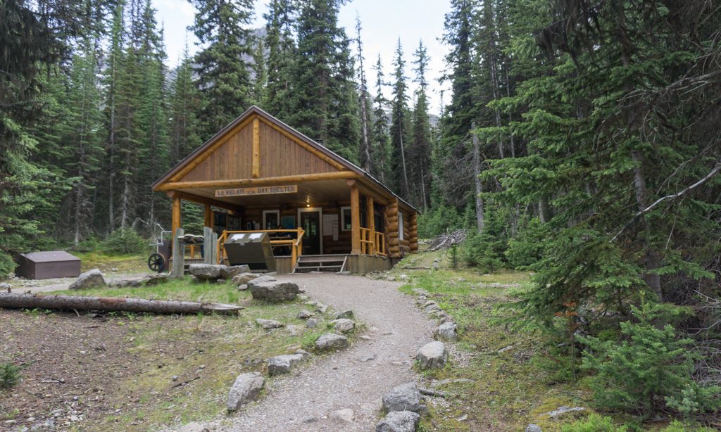
Toilets: Outhouses near the trailhead (beside Le Relais). There are no other toilets on the Alpine Circuit.
Dogs: Allowed on leash on the Lake O’Hara trails and access road but prohibited on the shuttle bus and in the campground. Keep in mind that the steep terrain may not be appropriate for most dogs.
Caution: Many sections of the Alpine Circuit have sheer cliff edges and steep drop-offs where a slip could easily lead to injury or death. Use extra caution if the trail is wet, icy, or snowy. This is not a good trail for people who are afraid of heights.
Indigenous Context: Lake O’Hara is on the traditional territories of several Indigenous Nations, in particular, the Stoney Nakoda (Ĩyãħé Nakón mąkóce). Samuel Allen, a white American mountaineer, named these features using the Stoney language after hearing them from his Stoney guide.

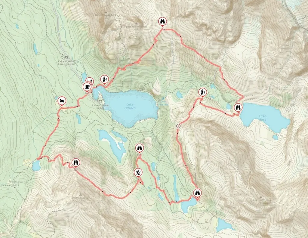
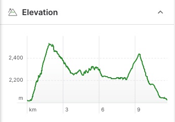
Lake O’Hara Alpine Circuit Map and Elevation Profile
The Lake O’Hara Alpine Circuit trails are easy to follow with signs at every junction. There are also painted yellow and blue markers on rocks to keep you on track.
But to help you find your way, I made you a trail map using Gaia GPS, my favourite GPS mapping app. Click through to zoom in and explore. All Trails+ is also great. If you prefer a paper map, the Lake O’Hara Map by Gem Trek is the best one out there.

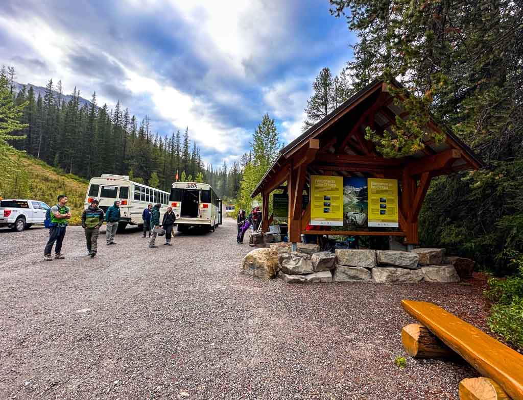
How to Get to Lake O’Hara
To get to Lake O’Hara you will first need to drive yourself to the parking lot. There is no public transportation available. From there, you will need to catch the shuttle bus or walk up the road.
Driving Directions
The Lake O’Hara parking lot is located in Yoho National Park in between the towns of Field, BC and Lake Louise, AB. It’s a 15-minute drive from Field and a 10-minute drive from Lake Louise. The turn-off from Highway 1 is well-signed. Click here for Google Maps driving directions.
You do have to cross train tracks to get into the parking lot, so allow yourself an extra 15 minutes in case you have to wait for a train.
Lake O’Hara Shuttle Bus
Lake O’Hara is 11 km up a gated gravel access road from the Lake O’Hara Parking Area. You can’t drive up the access road.
You can book a ride on the Lake O’Hara Shuttle Bus. Reservations for the entire season are assigned by lottery. In 2026, the lottery will be open for applications between March 2 and March 23.
However, you can keep checking back for cancellations or use a service like Campnab or Schnerp. Read my guide to camping cancellation apps to find out how they work and which one I recommend.
You can also get a ride on the Lake O’Hara shuttle if you book the Lake O’Hara Campground, the Elizabeth Parker Hut, or the Lake O’Hara Lodge. I’ve got lots more details on camping, the hut, the lodge, and the shuttle in my full guide to Lake O’Hara.

Walking the Lake O’Hara Road
If you can’t get a seat on the shuttle bus, you can also walk up the Lake O’Hara Road. It is 11 km each way with 425 m of elevation gain. Walking the road takes 3-4 hours. If there is space on the shuttle bus and you bring cash, you may be able to get a ride back down, but you shouldn’t count on it. It’s also worth noting that bikes aren’t allowed on the road.
Key Distances on the Lake O’Hara Alpine Circuit
| Location | Distance | Elevation |
|---|---|---|
| Trailhead at Le Relais | 0 km | 2025 m |
| Cataract Brook Bridge | 0.1 km | 2020 m |
| Wiwaxy Gap/Huber Ledges Start | 0.3 km | 2025 m |
| Wiaxy Gap | 1.8 km | 2525 m |
| Lake Oesa | 3.8 km | 2260 m |
| Yukness Ledges Start | 4.5 km | 2265 m |
| Hungabee Lake | 6.3 km | 2240 m |
| Opabin Prospect | 7.7 km | 2215 m |
| All Soul’s Route Start | 8.3 km | 2210 m |
| All Soul’s Prospect | 9.4 km | 2435 m |
| Schaffer Lake | 10.3 km | 2165 m |
| Elizabeth Parker Hut | 11.2 km | 2045 m |
| Trailhead at Le Relais | 11.7 km | 2025 m |
Lake O’Hara Alpine Circuit Hiking Directions
The Lake O’Hara Alpine Circuit hike is a loop hike that starts and finishes at Le Relais, the cafe and info centre. There are three main sections to the hike: Wiwaxy Gap/Huber Ledges, Yukness Ledges, and the All Soul’s Route. I’ve also included an optional (but highly recommended) detour to Opabin Prospect that adds just 0.7 km to your hike.
I’ve broken up the trail description below into those three ledge sections as well as the Opabin Prospect detour. If you aren’t up to doing the whole Alpine Circuit, you can use the Lake O’Hara Lakeshore Trail and other connecting trails to do one or two sections. I’ve also got some suggestions for variations on the Alpine Circuit below.
The circuit is most often hiked in a clockwise direction starting with Wiwaxy Gap, so that’s the way I have described it here. That way you get the biggest climb out of the way first. You can hike it in the other direction, but it’s less optimal since the sun won’t be in the best place for photos. As well, the trail builders intended the route to be hiked clockwise, so there are more markers in that direction.
A quick note on hiking times: My estimated times might seem long. But keep in mind that the terrain requires slow and careful steps and that you will want to take a million photos.
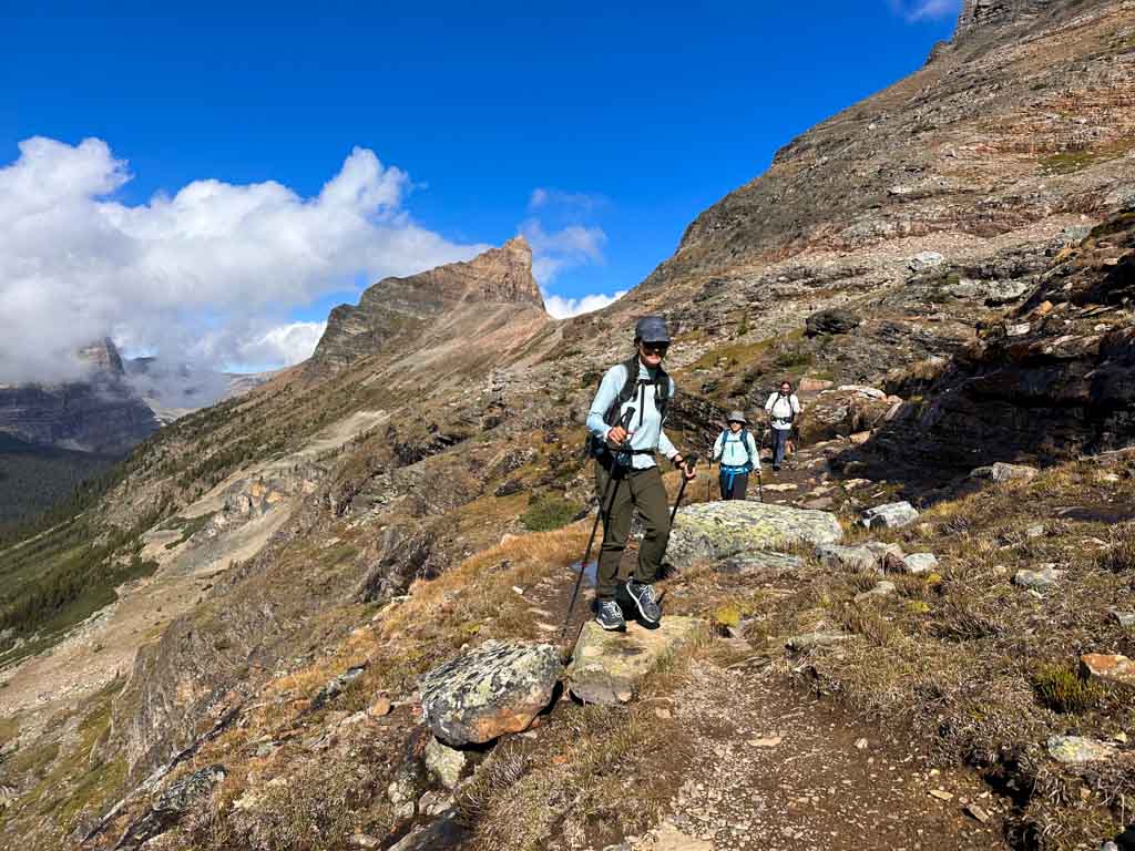

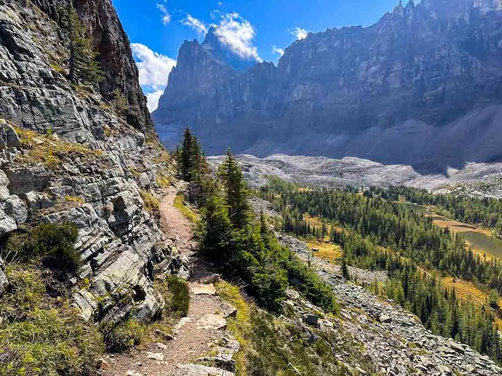
Wiwaxy Gap/Huber Ledges
Distance: 3.8 km
Time: 2-3 hours
Elevation Gain: 500 m
Elevation Loss: 260 m
Route: From the shore of Lake O’Hara up to Wiwaxy Gap, then down the Huber Ledges to finish at Lake Oesa.
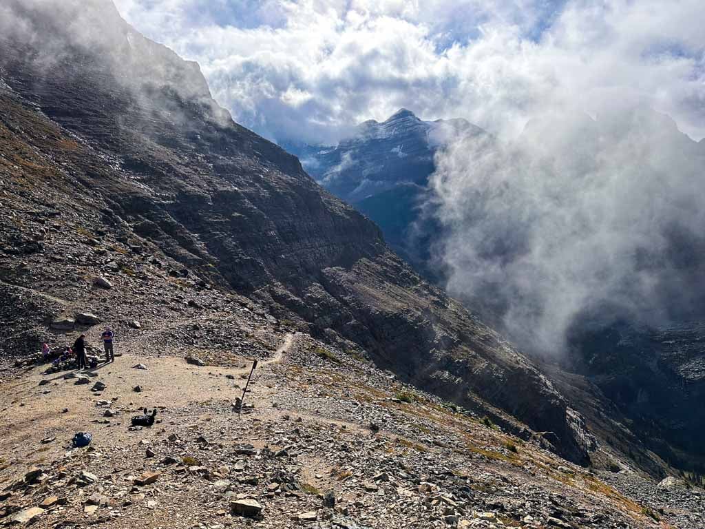
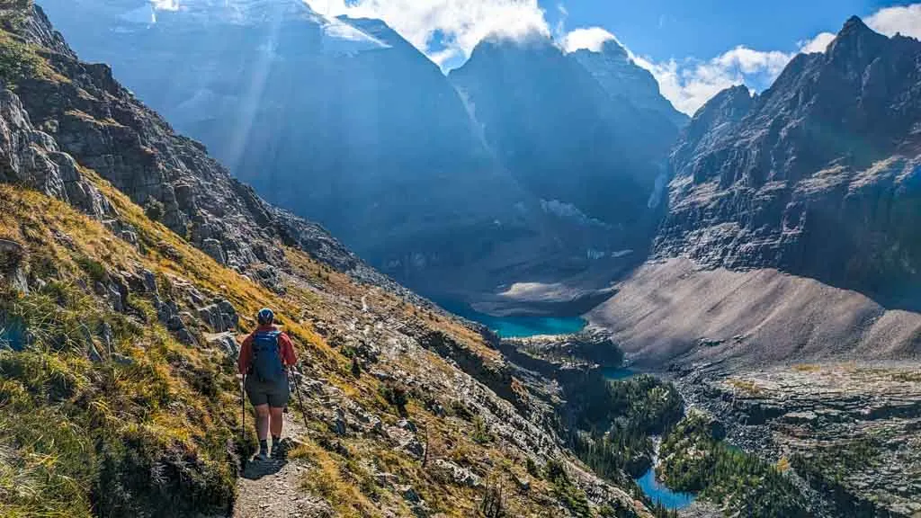
Most people begin their hike of the Alpine Circuit with the steep ascent to Wiwaxy Gap and then on to the Huber Ledges. This means that you do the toughest climb and reach the trail’s high point first thing.
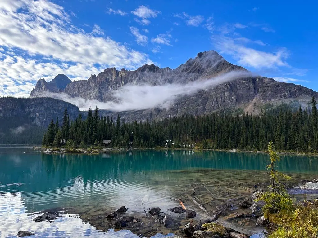
The trail starts opposite Le Relais and the bus stop. Follow the path to the lakeshore past a small historic Warden’s cabin. Stop for a few photos at the lake – the views of the cabins at Lake O’Hara Lodge are great. Then turn left to follow the Lake O’Hara trail around the lake and across a bridge over Cataract Brook. Ignore the trail going left before the bridge – it goes to the campground.
On the other side of the bridge, continue along the Lake O’Hara Trail as it winds along the shoreline for a few hundred meters. There are great views here too.

Watch for a signed junction going left to Wiwaxy Gap. Follow this trail steeply uphill through the trees. In a few minutes, the path enters a brushy avalanche chute and you begin to get some views of the slope above you as well as Lake O’Hara below you.
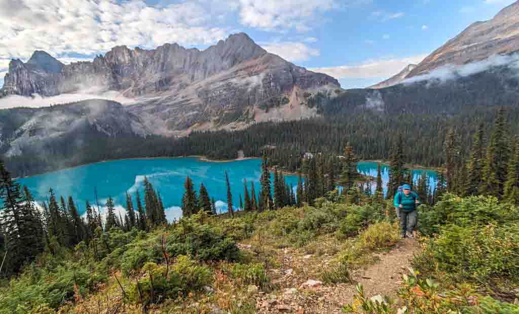

The climb is steep and steady, with lots of small switchbacks to help you upwards. About 0.8 km from the start, the grade eases for a moment as you traverse right under the base of a cliff. The climb begins again as you work your way upwards first through a few trees, then into the open gravel slopes. The views just keep getting better and better.
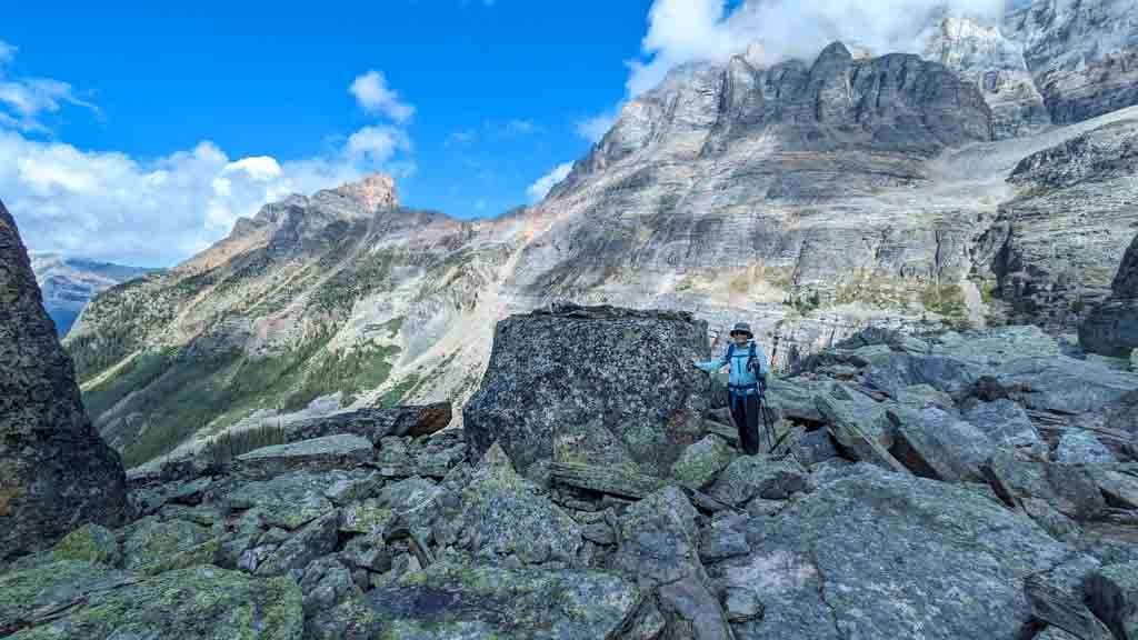
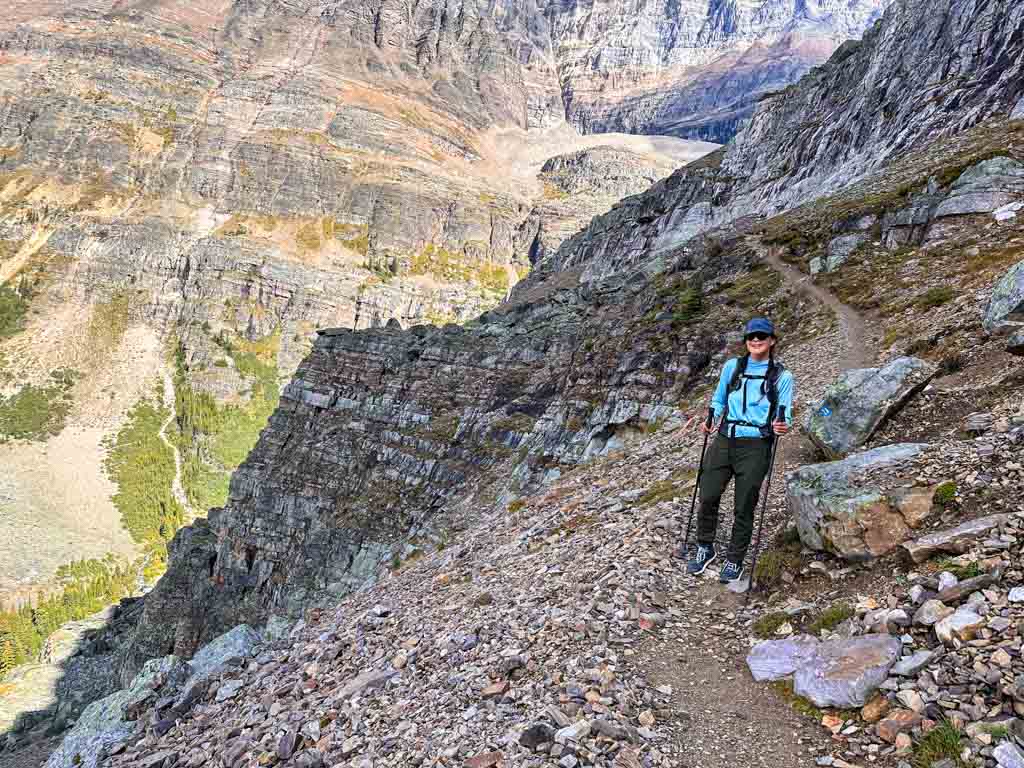
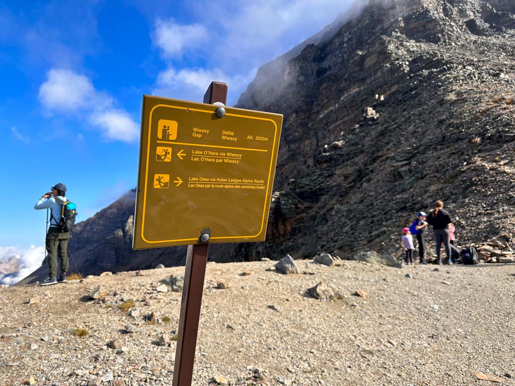
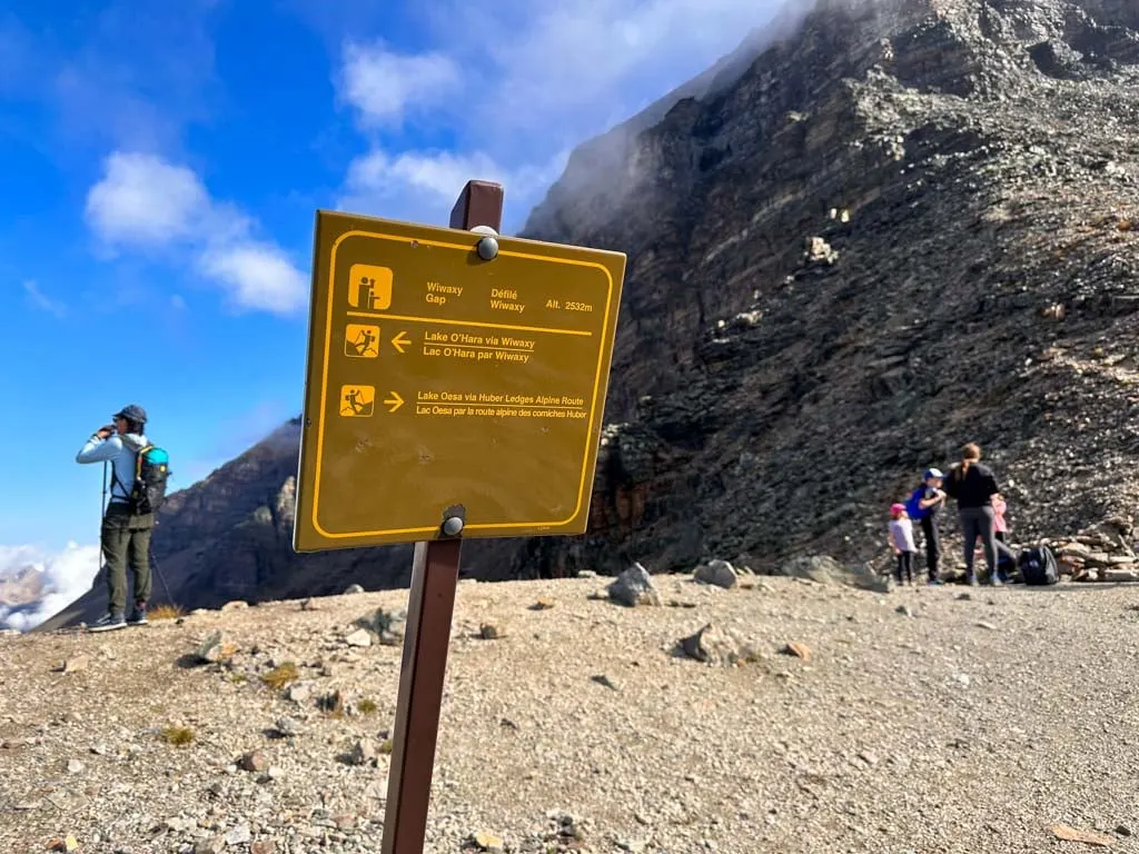
There are a few spots where you have to use some rock steps that may feel a tiny bit exposed, but nothing is too intimidating. Eventually, you will top out at Wixwaxy Gap 1.8 km from the start. You can look north through the gap to the slopes of Mount Victoria.

When you are ready, start your gradual descent down the Huber Ledges to Lake Oesa 2 km away. The Huber Ledges are named after Mount Huber since they follow cliff bands along its southern slope. The mountain is named after Emil Huber, a Swiss mountaineer who made several first ascents in the Rockies and Selkirks.
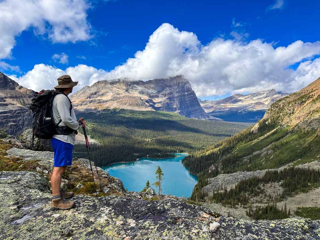
The views are incredible as you look down to Lake O’Hara, Lake Oesa and the smaller lakes in between. I was also lucky enough to spot mountain goats in this section.

Take your time on the ledges. There are a few narrow sections, but it isn’t as steep and precipitous as it looks from the valley floor. For most of the walk, you’ll be on a narrow trail between steep gravel slopes. There are very few places where it feels like a cliff.


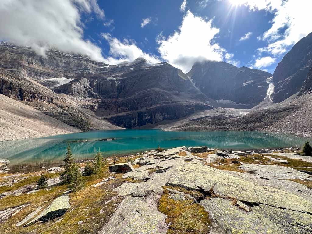
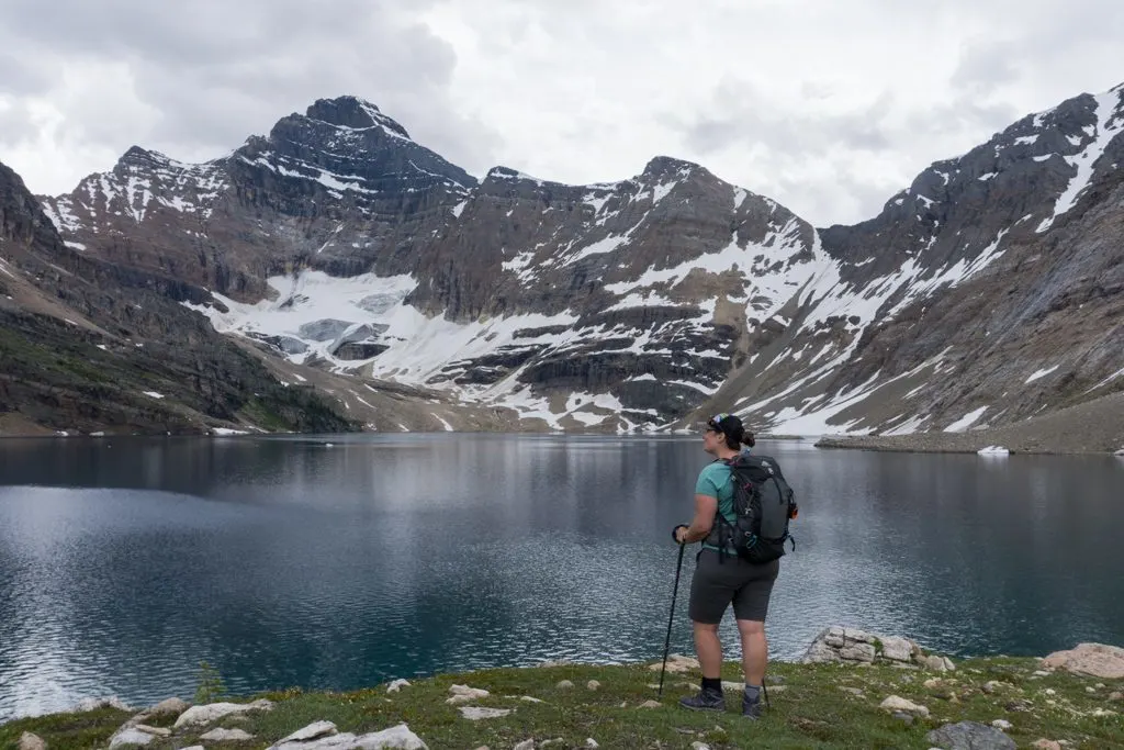
Eventually, you will reach a junction with the Lake Oesa Trail coming in from your right. Go straight towards the lakeshore. This is a good spot to take a break (and maybe top up your water) before starting the next section. Lake Oesa gets its name from the word for “corner” in the Stoney language.
Yukness Ledges
Distance: 2.5 km
Time: 1-2 hours
Elevation Gain: 70 m
Elevation Loss: 90 m
Route: From Lake Oesa, along the Yukness Ledges to finish at Hungabee Lake on the Opabin Plateau.
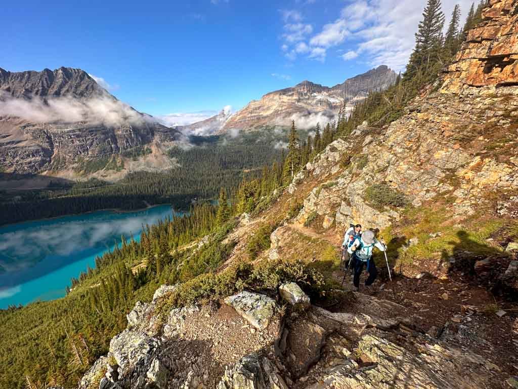
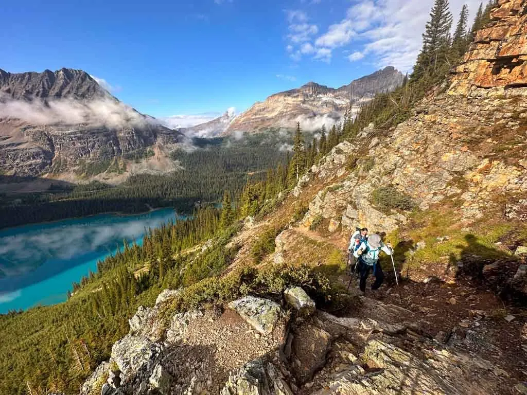
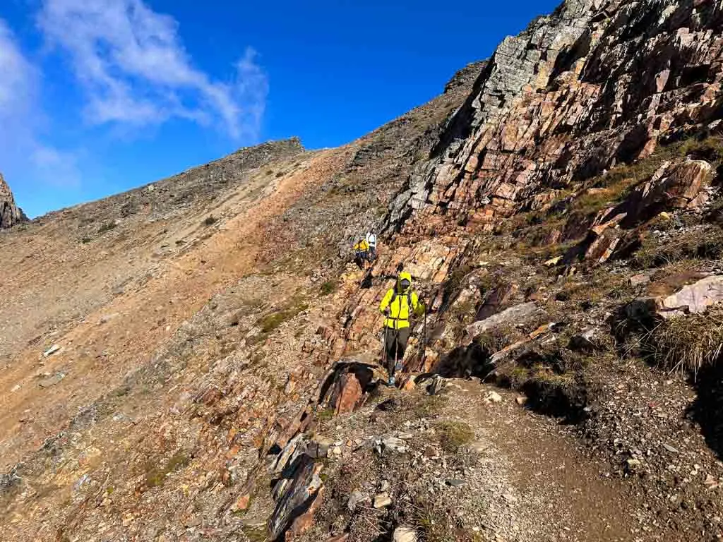
The Yukness Ledges are often considered the easiest of the three ledges since they have the least elevation gain and loss. As well, they appear to be the least precipitous when viewed from the lake. However, those with a fear of heights may not like some of the terrain here as it is narrow and drops away sharply in a few spots.
These ledges are named after Yukness Mountain, since they skirt around its flank. Yukness means “sharpened” in the Sioux language. Samuel E. S. Allen, one of the early mountaineers in the area, chose the name to describe the mountain. However, the Sioux do not have traditional territory at Lake O’Hara – they are plains people.
Leaving Lake Oesa, follow the trail uphill across the rock slabs. It can be a bit indistinct in a few places and there are multiple options. But look for the paint on the rocks and head for the lake outlet stream to find the right way. Follow the trail markers to cross the stream and begin ascending a rocky slope.

After the trail begins to descend slightly, watch carefully for markers as the trail weaves through boulders. It is easy to get off-track here. (Ask me how I know!) Make sure you are following the markers as the trail descends and curls slightly right (northwest).

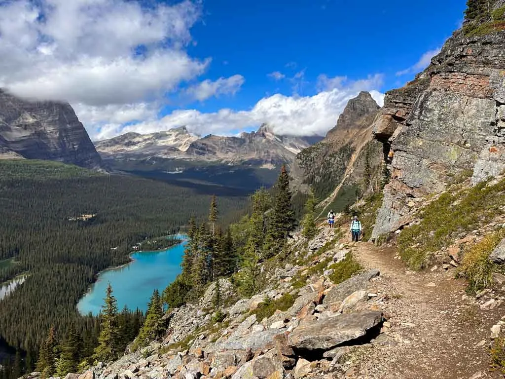
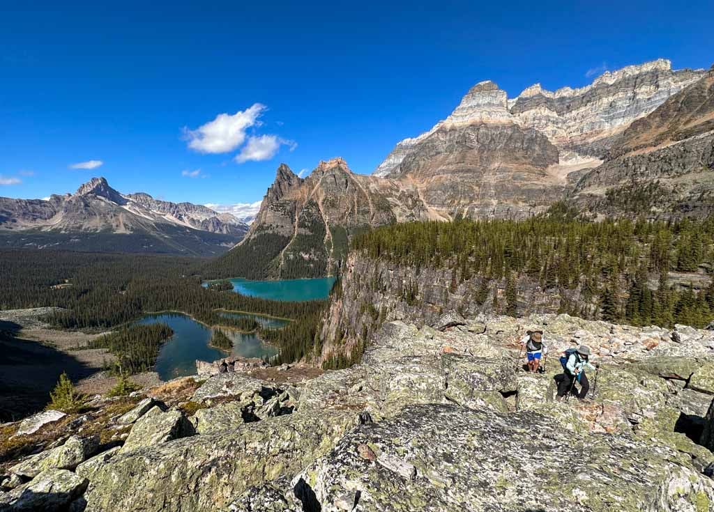
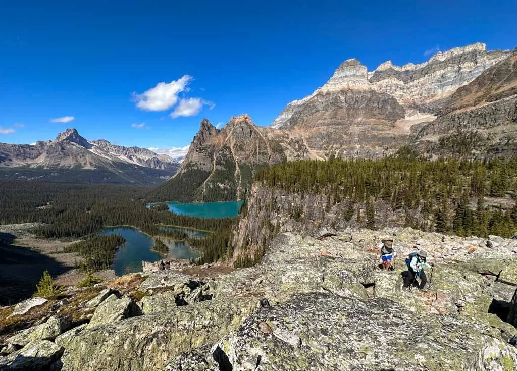
Reach the junction with the trail to Victoria Lake 4.5 km from the start (0.7 km from Lake Oesa). This is the official start of the Yukness Ledges. Follow the trail left as it travels across rock slabs. There are incredible views of Lake O’Hara, Odaray Mountain, and Cathedral Mountain. You can also look back to your route along the Huber Ledges.

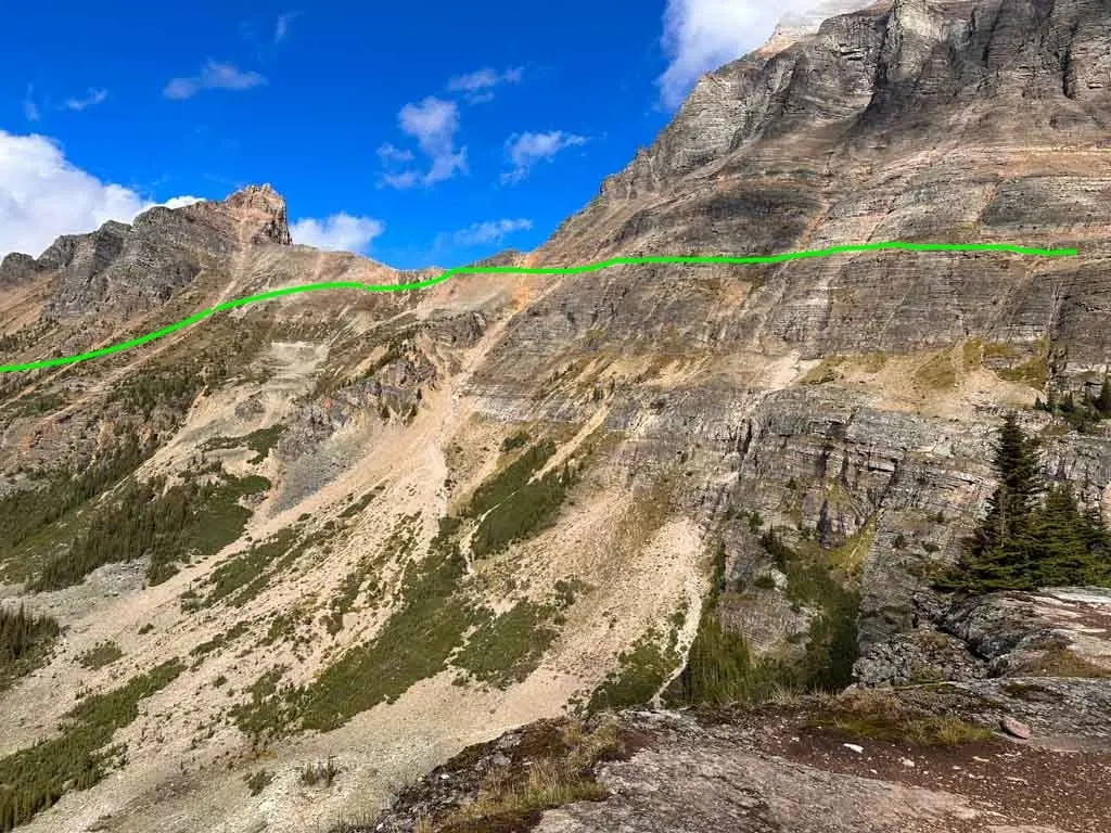
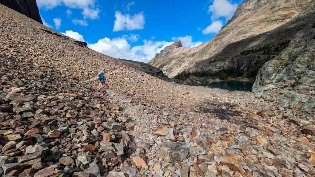
Continue along the trail as it traverses more rock slabs, ledges, and scree slopes. There are a few places that look intimidating as you approach, but are not as scary once you are actually there. The trail reaches its high point and then turns to head south.


The final kilometre is along the base of a cliff. At first, your route is along a grassy ledge. But then it descends into a talus slope. Watch for curious marmots and pikas in the rocks here. There is some tricky footing and the last part of the descent is steeper, but some carefully placed rocks make the hiking easier.

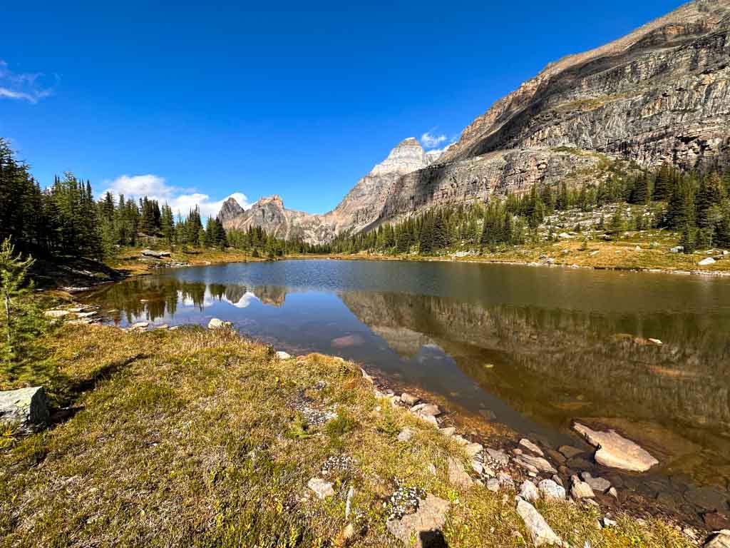
Arrive at the shores of Hungabee Lake and the junction with the East Opabin Trail to finish the Yukness Ledges. Samuel Allen named the lake after the Stoney word for “chieftan” since it is higher than its neighbouring peaks.
Opabin Prospect Detour
Distance: 2 km
Time: 30-45 min
Elevation Gain: 30 m
Elevation Loss: 20 m
Route: Across the Opabin Plateau, detour to Opabin Prospect, and finish at the start of All Soul’s Route.
The traditional Lake O’Hara Alpine Circuit makes a bee-line across Opabin Plateau from Hungabee Lake to the start of the All Soul’s Route. The bee-line option is 1.3 km long goes downhill on the East Opabin Trail, then goes left along Hungabee Lake to connect with the West Opabin Trail to the All Soul’s Route.
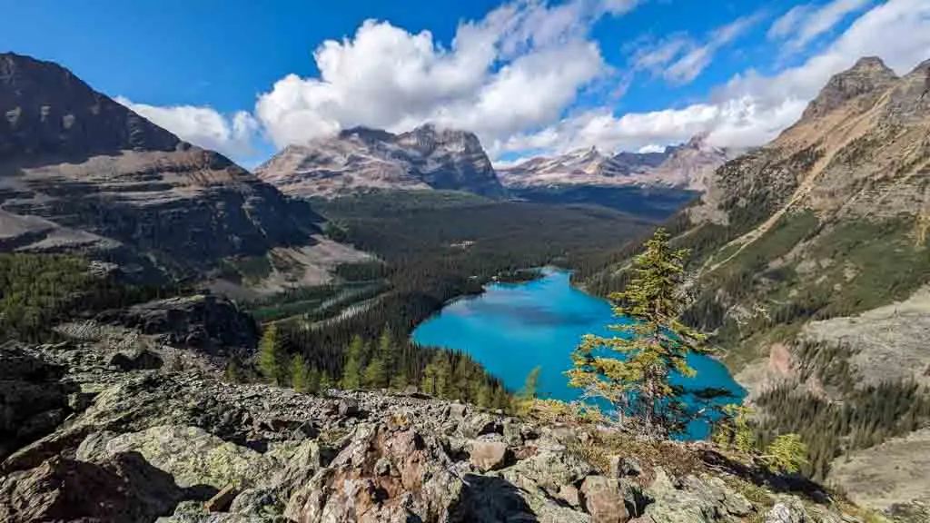
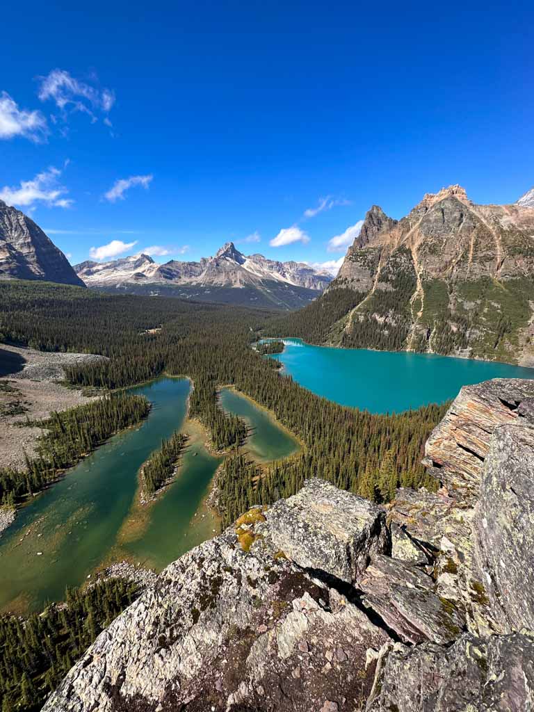
However, I think it’s worthwhile to take a 0.7 km detour along the Opabin Prospect Trail. This option takes you to one of the best views in the Lake O’Hara area. Find it by turning right just after the junction with the Opabin Highline Trail.
Follow the Opabin Prospect Trail as it winds past small lakes and through beautiful stands of larch trees, which are gorgeous when they turn yellow in late September.
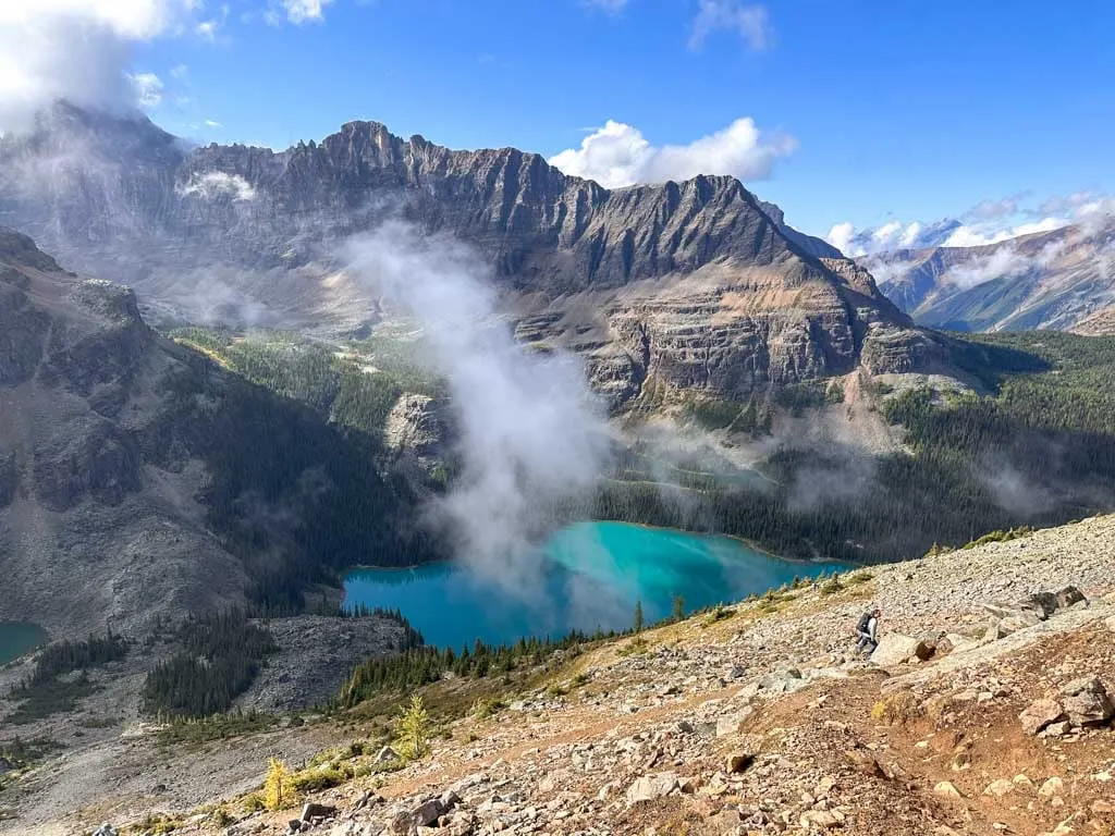
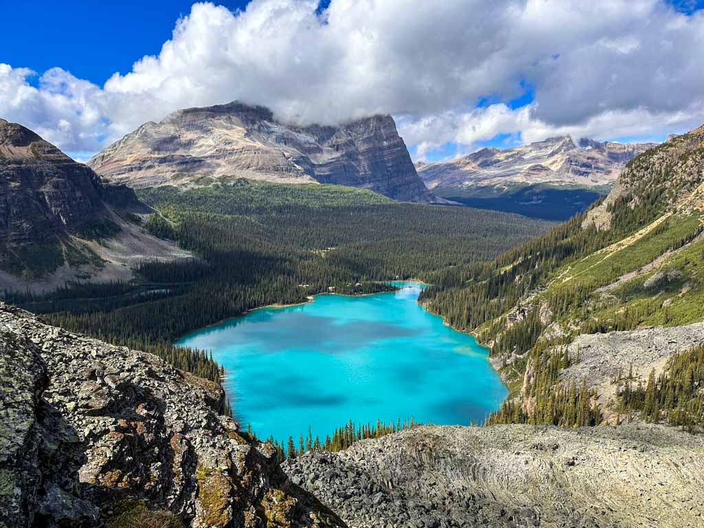
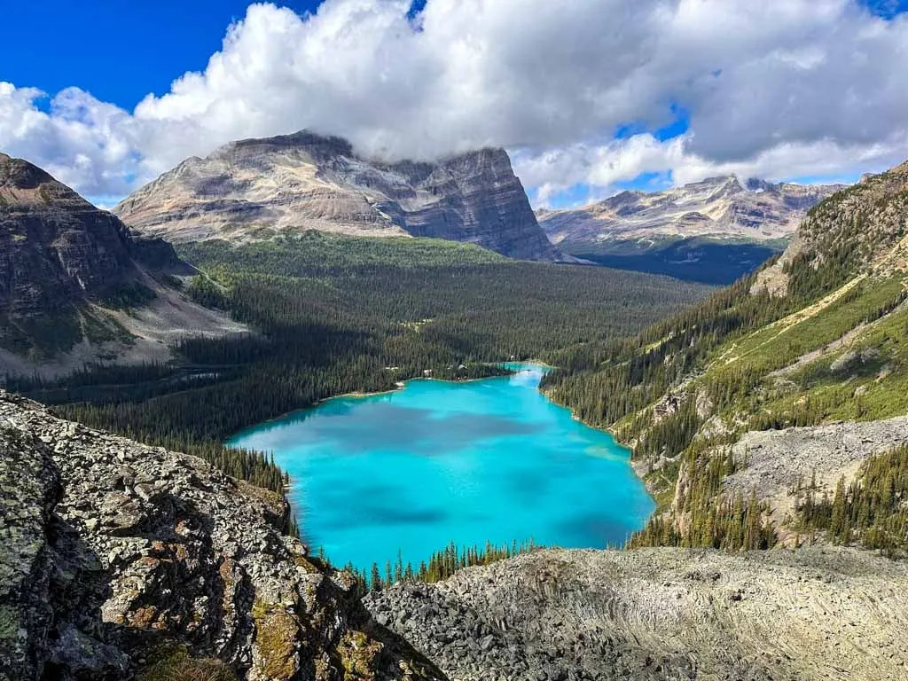
The Trail emerges from the trees at a clifftop viewpoint. Lake O’Hara and Mary Lake are spread out below you. The rock slabs by the cliff are large so it doesn’t feel too scary. This is probably the most famous viewpoint and photo location at Lake O’Hara, so you don’t want to miss it.

When you are finished admiring the view, continue following the Opabin Prospect Trail as it loops back south and heads briefly downhill to a junction with the West Opabin Trail. Turn right and go downhill through a gully a few minutes to another junction. This is the official start of the All Soul’s Route.
All Soul’s Route
Distance: 3.4 km
Time: 2-3 hours
Elevation Gain: 225 m
Elevation Loss: 410 m
Route: Starts at the western side of the Opabin Plateau, climbs up to All Soul’s Prospect, then descends to pass Schaffer Lake and the Elizabeth Parker Hut on the Way back to Le Relais.
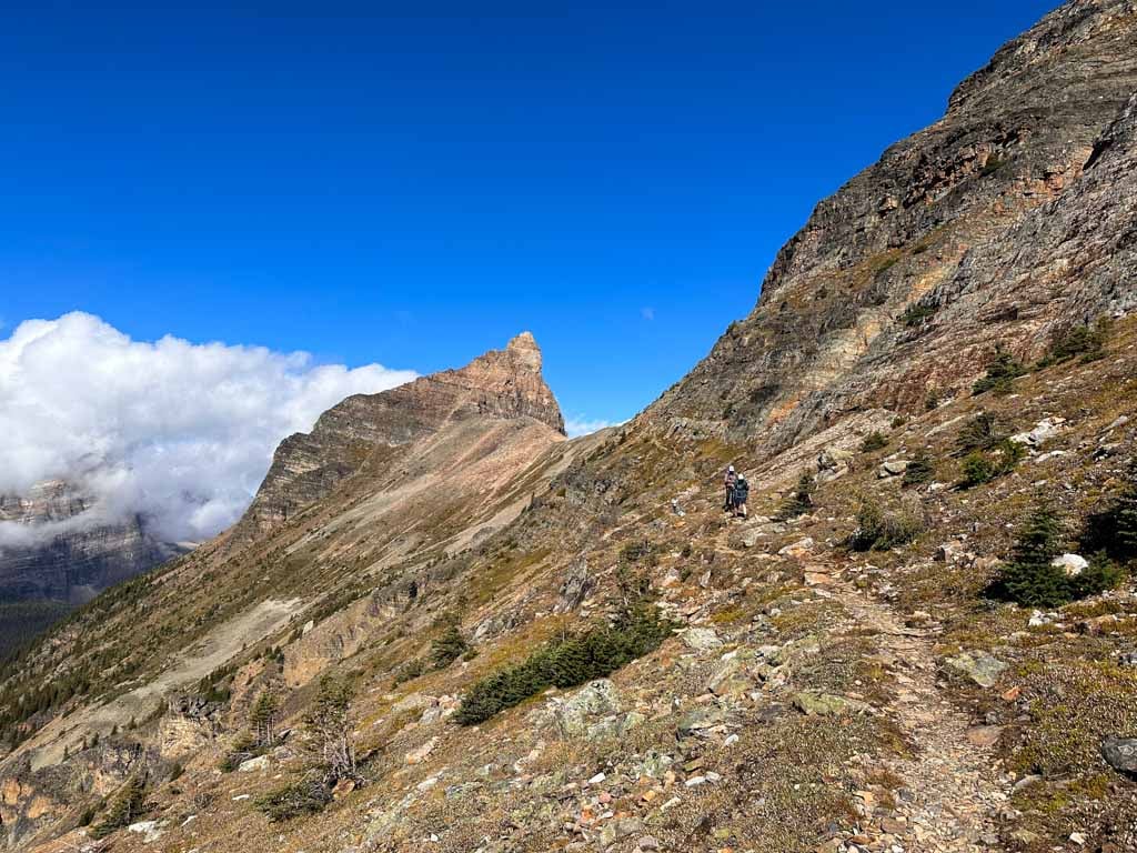
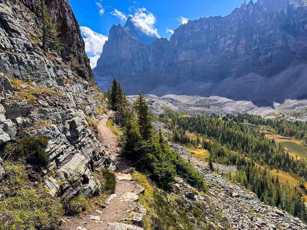
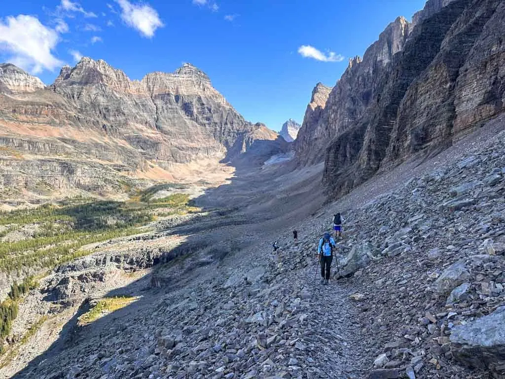
The final section of the Lake O’Hara Alpine Circuit is the All Soul’s Route. While this section doesn’t have any ledges, it does have a lot of steep gravel slopes that can feel quite exposed.
The All Soul’s Route starts at a junction on the West Opabin Plateau Trail. It climbs up through a rocky section and then along the top of a cliff (although well back from the edge so it isn’t scary).
Next, the route swings around to the northwest and starts the long climb up a gravel and scree slope. Since the slope is in the shade most of the day, snow can linger here. Microspikes and trekking poles can be helpful here early in the summer.


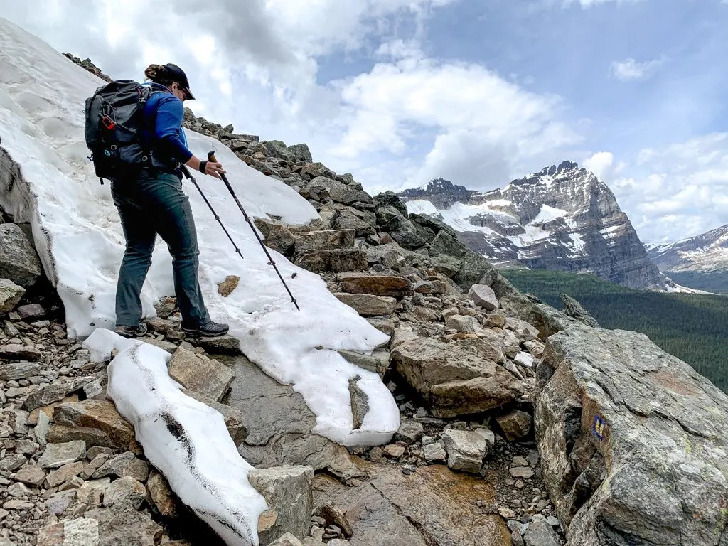
The final push to the top of All Soul’s Prospect is steep, but the view from the top is incredible. Lake O’Hara is directly below you and Wiwaxy Gap is just across the lake. The banded rock of Mount Huber is stunning. You can also look north to Elizabeth Parker Hut in the meadows far below you.

After you’ve taken a break at the viewpoint, you will need to tackle the descent to Schaffer Lake. This section is incredibly steep with many small switchbacks and rock steps. You will need to watch your step carefully in some areas.

Once you reach the trees, the steepest part is over. Ignore the Big Larches Trail going right and continue another few minutes to the junction with the Alpine Meadows Trail near the end of Schaffer Lake. Turn right and follow the Alpine Meadows Trail is heads downhill through thick forest.
Emerge from the forest into a meadow as you walk past the Elizabeth Parker Hut. More info about staying at this Alpine Club of Canada Hut is in my Lake O’Hara hiking and camping guide.
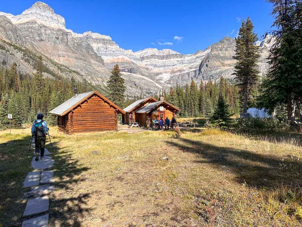
On the other side of the meadow, head back into the trees. Go left at a junction, following signs for Le Relais. Arrive at Le Relais and end your hike a few minutes later.
Be sure to grab a snack at Le Relais. The carrot cake is incredible, although it does sell out so you will need to hike fast. But their other baked goods are also tasty. And they have pop and ice cream too. All proceeds go to the non-profit Lake O’Hara Trails Club for trail maintenance and interpretive programs.

Lake O’Hara Alpine Circuit Variations
There are lots of trail options at Lake O’Hara. Here are my recommendations for add-ons if you want to make the Alpine Circuit longer and some shorter hikes that just use part of the Alpine Circuit.
Alpine Circuit Add-Ons
If you have extra time and energy, here are a few options you could add on to the Lake O’Hara Alpine Circuit:
- Opabin Lake: A pretty little lake in an alpine basin. From Hungabee Lake, go left on the East Opabin Trail to Opabin Lake, then circle back on the West Opabin Trail. This adds 1 km and 50 m of elevation gain
- Lake McArthur: A huge deep blue lake in a glacial cirque. From Shaffer Lake turn left and follow the trail to Lake McArthur. You can make a loop by using the lower trail in one direction and the upper trail in another. Adds 4 km and 150 m of elevation gain to the Alpine Circuit.
- Odaray Grandview: A spectacular viewpoint above all of the lakes in the Lake O’Hara area. Turn left from Schaffer Lake, then right onto the McArthur Pass Trail to reach the trailhead for Odaray Grandview. Due to wildlife protection, only a few groups can use this trail per day so go early and do the Alpine Circuit in the reverse direction. Check the visitor log at the trailhead to see if it is full. The trail climbs up the slope to the viewpoint. This adds 3.6 km and 355 m to your trip.
- Big Larches/Lake O’Hara Lodge: Adds a brief walk along the shore of Lake O’Hara and a close-up view of the lodge cabins but skips Elizabeth Parker Hut. On the descent from All Soul’s Prospect, turn right onto the Big Larches Trail and follow it to the lake. Turn left, following the lake around the lodge buildings to return to Le Relais. Adds 0.8 km to your trip.

Partial Alpine Circuit
If there is snow on some of the ledges or you don’t want to do all of them, you can do each of the three ledge sections separately. You can also combine each ledge section with nearby scenery to make a beautiful loop. Look at the Lake O’Hara map to plan your trip. Or use some of these suggestions:
- Wiwaxy Gap/Huber Ledges/Lake Oesa: Head up to Wiwaxy Gap and along the Huber Ledges to Lake Oesa. Then follow the Lake Oesa Trail down to Lake O’Hara. Once at the lakeshore, you can choose which way to return along the lake. Distance: 6.5-7.5 km. Elevation Gain: 500 m. Time: 3.5-4.5 hours.
- Lake Oesa/Yukness Ledges/Opabin Prospect: Follow the trail along the north shore of Lake O’Hara to the Lake Oesa Trail. From Lake Oesa, take the Yukness Ledges to Hungabee Lake, then walk the Opabin Prospect Route. Head back to Lake O’Hara via the West Opabin Trail and use the lakeshore trail to get back to Le Relais. Distance: 9 km. Elevation Gain: 305 m. Time: 3-5 hours.
- Lake McArthur/All Soul’s Prospect: Combine a trip to Lake McArthur with a trip to All Soul’s Prospect. From this direction, it’s a stiff ascent and gentler descent. From Le Relais, take the Alpine Meadows Trail past Elizabeth Parker Hut to Schaffer Lake. Follow the Upper and Lower Lake McArthur trails to make a loop and return back to Schaffer Lake. Then go up and over All Soul’s Prospect. Use the West Opabin Trail and the lakeshore trail to return to Le Relais. Distance: 9.4 km. Elevation Gain: 560 m. Time: 4-5.5 hours.
Lake O’Hara Hiking Tips
After several trips, here are my top tips for hiking at Lake O’Hara:
- Join the Lake O’Hara Facebook group to get advice, ask questions, and get trail conditions updates.
- Make reservations as early as possible for the shuttle bus (or to stay at the campground, Elizabeth Parker Hut, or Lake O’Hara Lodge). See my full Lake O’Hara guide for more info.
- Check the weather so you know what to expect. Spotwx is my top picks for weather prediction, but I’ve got more choices in my guide to the best weather apps for hikers.
- Pack a rain jacket and warm layers, no matter what time of year you visit. The weather can change quickly. My Lake O’Hara packing list has more details.
- Bring microspikes if you plan to hike in June, early July, late September, or October. The trails will have snow and ice. (Read my guide to microspikes vs. crampons to find out what kind you need for hiking.
- Pack hiking poles – they can be helpful on the steep ascents and descents. They might also help you feel a bit more surefooted and balanced on the precarious ledge sections. They are also essential if there is now.
- Bring a water filter in hot weather. That way you won’t have to carry as much water. I like the tiny Katadyn BeFree since it is easy to fill and filter.
- Bring bear spray and keep it strapped to the outside of your pack. Lake O’Hara is grizzly bear country. Bear spray is especially important if you hike to Lake McArthur and the Odaray Highline. Read my guide to bear safety for more tips.
- Pack cash so you can buy snacks and souvenirs at Le Relais. Try to time your visit for early afternoon to get a slice of the famous carrot cake.
- Bring a map or GPS so you can plan your route. There are lots of signs at junctions so you won’t get lost, but a map (like the GemTrek Lake O’Hara Map) or a GPS app (like Gaia GPS or AllTrails+) lets you plan a route that hits the highlights.
- Hang on to your bus token. When you get on the bus to the lake, you will get a token (that looks like a poker chip). This is your ticket for the bus out. Keep it in a safe place! If you don’t have a token, you have to pay cash and aren’t guaranteed a ride out.
- Keep an eye on the time as you hike – you don’t want to miss the last shuttle bus!

That’s everything you need to know to hike the Lake O’Hara Alpine Circuit in Yoho National Park. If you have questions, ask them in the comments as I would love to help.
READ NEXT:
- Lake O’Hara Camping and Hiking Guide (Yoho National Park)
- Lake O’Hara Packing Lists for Hikers and Campers
- Join the Lake O’Hara Facebook group
- Things to Do in Yoho National Park
- 11 Best Backpacking Trips in the Canadian Rockies
- Backpacking the Yoho Valley Loop/Iceline Trail


- Best Sun Hoodies for Hiking - June 3, 2026
- Lower Stein Valley Trail Hiking and Backpacking Guide - May 27, 2026
- The Best Things to Do in Vernon, BC - May 21, 2026