

With Arches and Canyonlands National Parks nearby and tons of gorgeous BLM land, there are tons of trails in Moab, Utah. But if you’re a beginner, hiking with kids, or just short on time, you need to know about the best easy hikes in Moab.
I recently spent a week in Moab and did a ton of hiking. As a long-time hiker and guidebook author, I’m used to tackling long and difficult hikes. But on this trip I was recovering from an injury so I focused on short and easy trails that would be kind to my body.
I was worried that the easier hikes wouldn’t be as good… but I was so wrong! We saw incredible scenery every day from arches to canyons to rock formations. We also visited must-sees like Delicate Arch and Landscape Arch.
Now that I’m back from my trip, I’ve put together my list of the 15 best easy hikes in Moab for you. While all of these hikes are on the easier side, some of them are harder than others. I’ve rated them either “super-easy“, “easy” or “moderate” so you know what to expect.
Most of the hikes take less than 1 hour, but a few take up to 3 hours. In general, these trails aren’t too steep – most climb less than 100 feet. But a few have more hills. Some also contain slickrock sections, stairs, ladders, and ledges that some people will find challenging.
This guide to short hikes in Moab includes:
- Quick picks – my top 4 easy Moab hikes
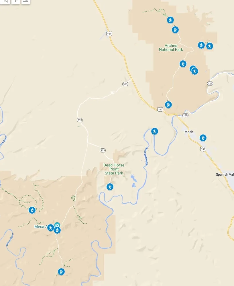
- Moab hiking map that shows the location of every trailhead
- Hikes in Arches National Park
- Hikes in Canyonlands National Park
- More hikes near Moab
- Moab hiking tips including fees, reservations, weather, dogs, and more
This is a sensitive wilderness area. Learn how to Leave No Trace to keep the wilderness wild. Make sure you are prepared by bringing the 10 Essentials. Get ready for adventure with this checklist of things to do before every hike.
Hey there: Some of the links in this post are affiliate links, which means I earn a small commission at no cost to you. Thanks for your support. -Taryn
Easy Hikes in Moab Quick Picks

Best Easy Hike to an Arch: Double Arch
Best Easy Hike to a Canyon Viewpoint: Grand View Point
Best Super-Short Easy Hike: Balanced Rock

Best Longer Easy Hike: Corona Arch
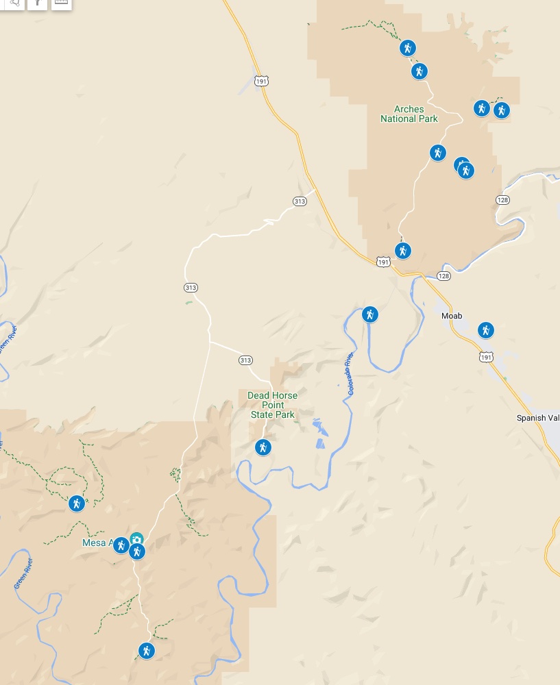
Moab Hiking Maps
All of the hikes on this list are easy to follow with lots of signs and trail markers. But using a hiking app like Gaia GPS or AllTrails+ can help if you’re worried about getting off track.
If you want a paper map, we bought the Classic Moab Trails Recreation Topo Map which shows tons of hiking, biking, and OHV trails.
I also made a custom Google Map for you that shows the locations for the start of all the easy hikes in Moab. But don’t use Google Maps once you are on the trails – in some places, there is no cell service and Google doesn’t have all the trail details anyway.
Easy Hikes in Arches National Park
One of the main places to hike near Moab is Arches National Park. You’ll find lots of easy hikes there.
- Entry Fees: Entry to the park costs $30 per vehicle and is good for one week. Annual passes are also available.
- Reservations: Between April 1 and October 31 visitors entering the park between 7 am and 4 pm need to make a reservation for a timed entry ticket. (You don’t need a reservation at other times.)
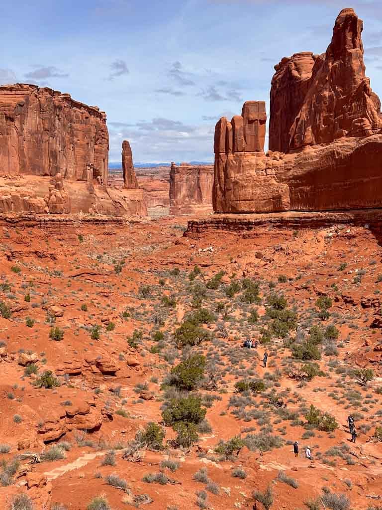
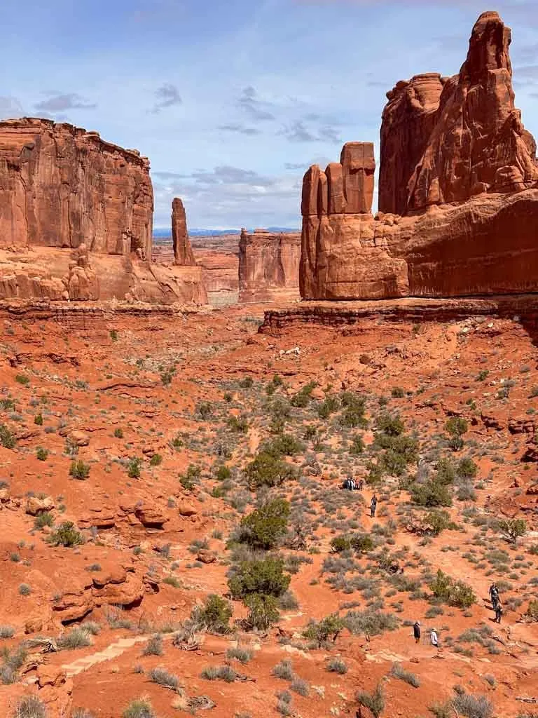
Park Avenue Trail
Difficulty: Easy
Time Needed: 1 hour
Distance: 1.8 miles round-trip
Elevation Gain: 322 feet
This trail starts at the paved Park Avenue viewpoint platform. From there, it goes down a set of stairs and follows a wide canyon between tall rock towers… kind of like walking down Park Avenue in New York!
The trail heads downhill to the Courthouse Towers viewpoint, which means the way back is entirely uphill so save your energy for that.
Here are Google Maps driving directions to the Park Avenue trailhead.
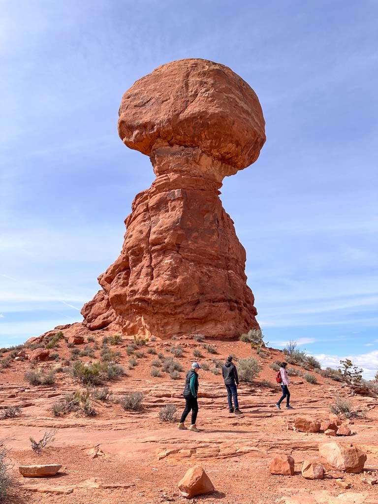
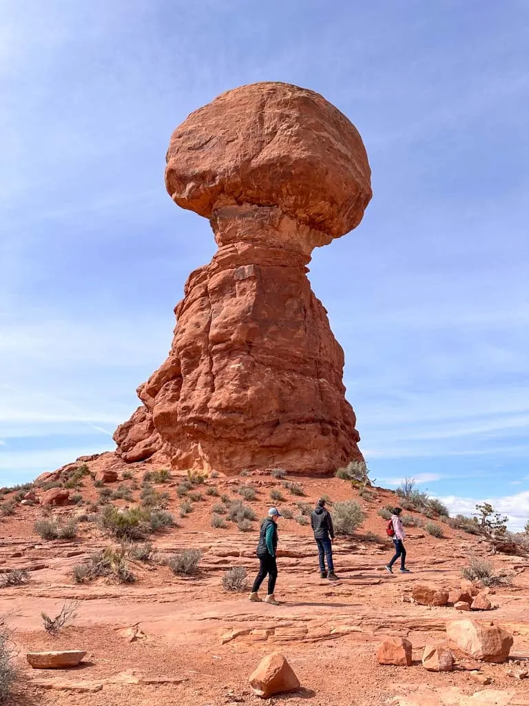
Balanced Rock
Difficulty: Super-easy
Time Needed: 15 minutes
Distance: 0.3 miles
Elevation Gain: 35 ft
Balanced Rock seems to defy gravity. When you see it from the road it looks precarious, but it isn’t until you walk the short loop trail around the base that you really understand how crazy it is that it’s still standing. The hike is short and easy, but worthwhile.
Here are Google Maps driving directions to the Balanced Rock trailhead.
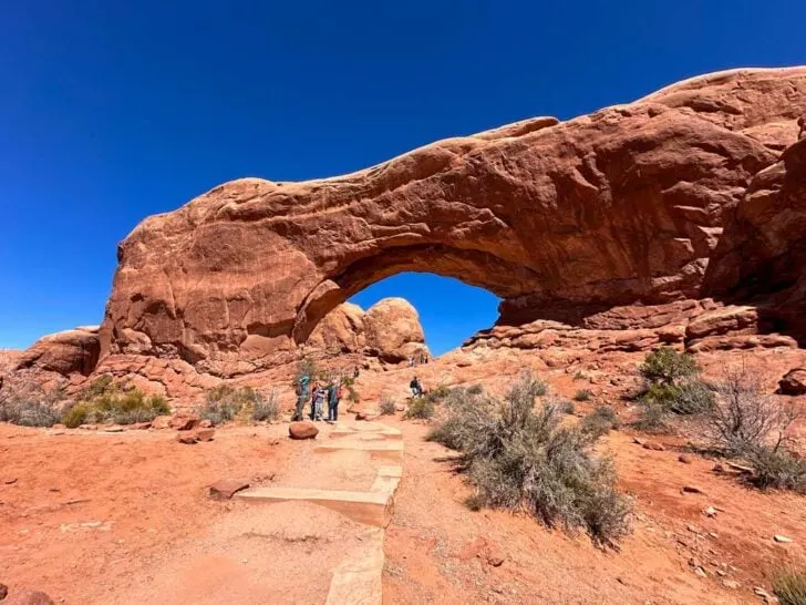
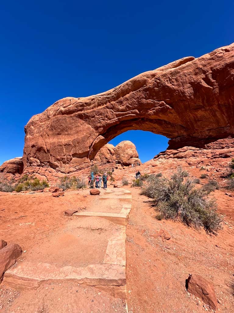
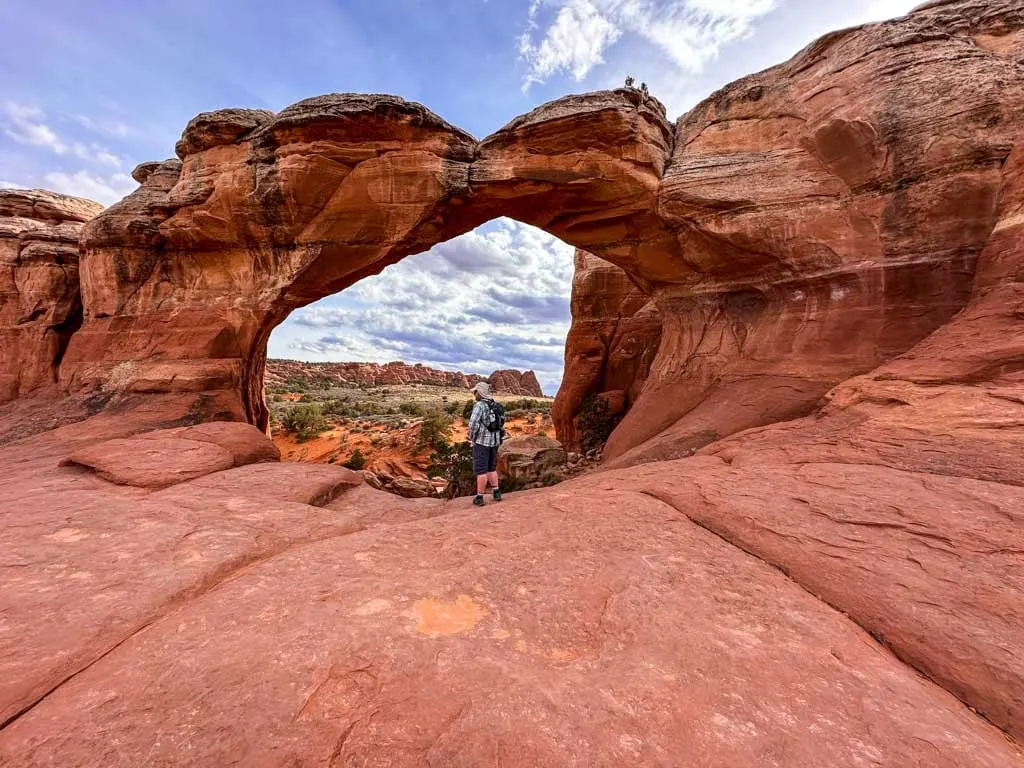
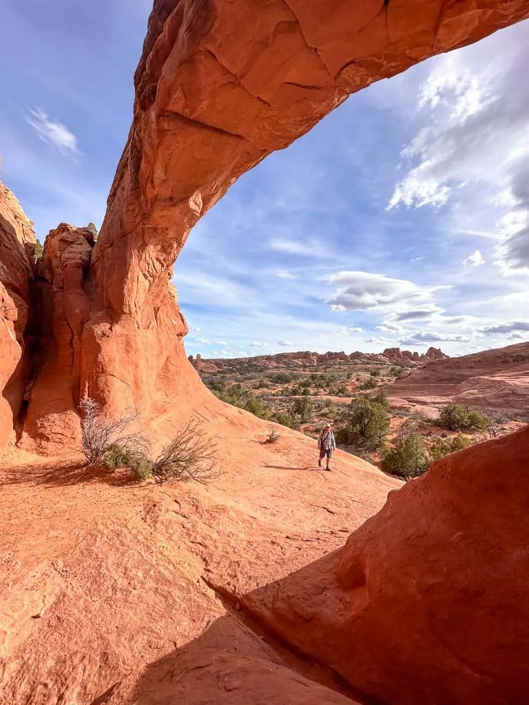
Windows Trail
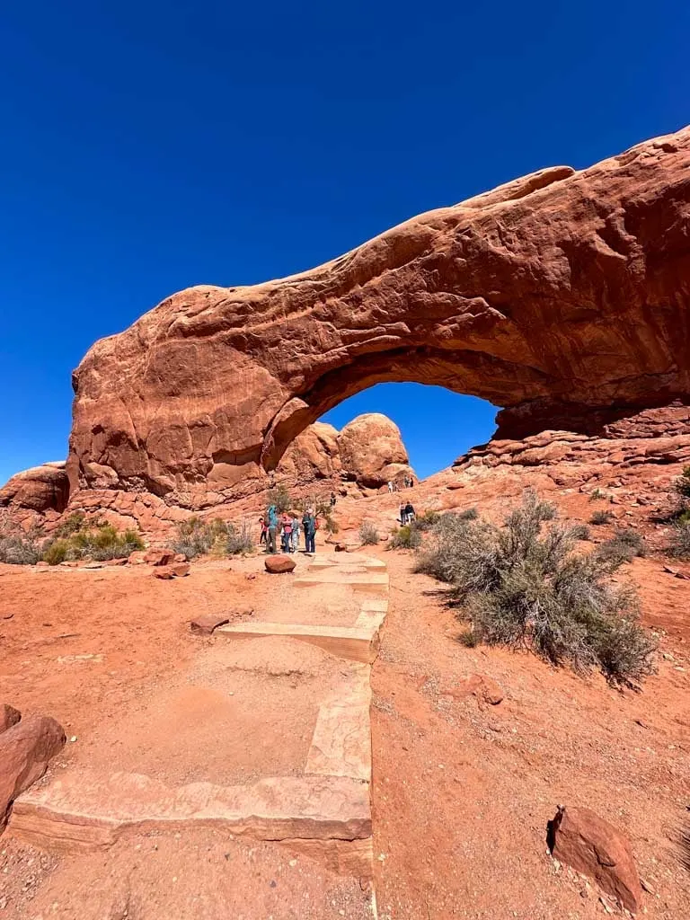
Difficulty: Easy
Time Needed: 30 minutes
Distance: 1 mile loop
Elevation Gain: 99 ft
This short and easy trail has a great payoff – these are some of the most spectacular arches in the park. It’s a loop hike that starts and ends with a few stairs. I recommend going counterclockwise. On this route, you will start at Turret Arch. Next, you will visit South Window and North Window.
Since this hike is so short, you can do Double Arch at the same time – it starts from the other side of the parking lot.
Pro tip: This is a great place for a sunset hike since the North Window frames the setting sun.
Here are Google Maps driving directions to the Windows trailhead.
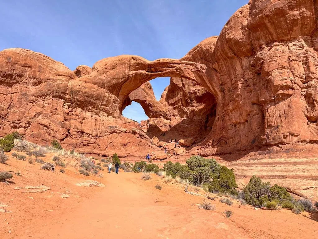
Double Arch
Difficulty: Super-easy
Time Needed: 20 minutes
Distance: 0.6 mi round-trip
Elevation Gain: 30 ft
Double Arch was one of my favourite arches – it’s two arches stretching across the same alcove. It’s also the tallest arch in the park at 112 ft. The hike to Double Arch is one of the easiest trails in Moab.
You can see the arch from the parking lot, but you will still want to follow the path downhill to get closer. There is a great view from the base but you can also scramble up into the arch.
Here are Google Maps driving directions to the Double Arch trailhead.
Delicate Arch Viewpoint

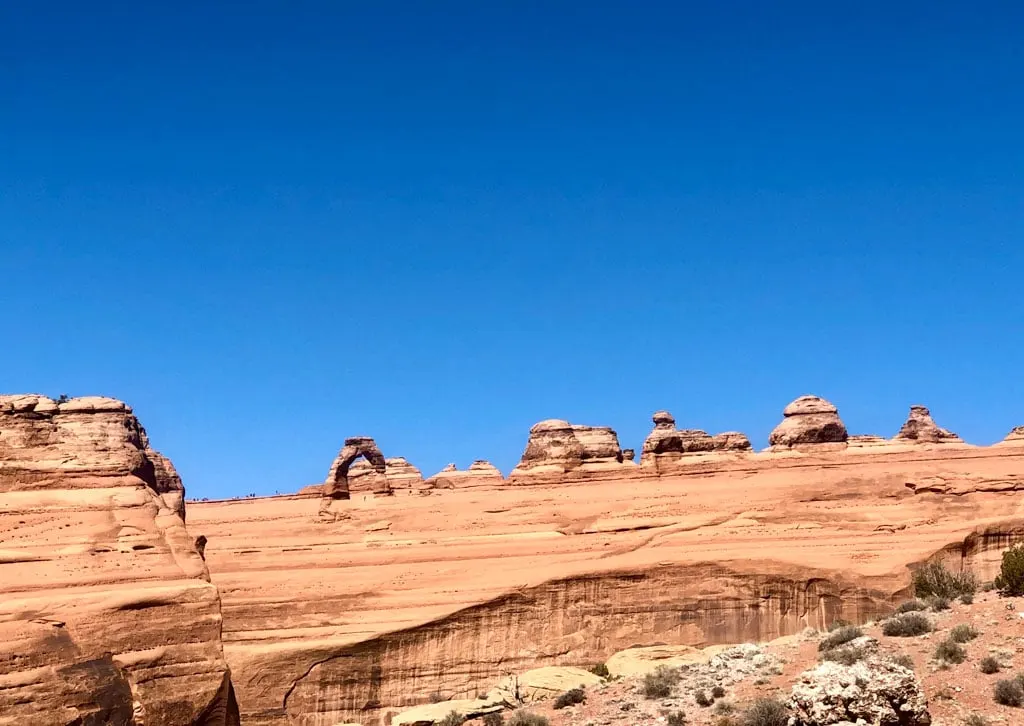
Difficulty: Easy
Time Needed: 30 to 45 minutes
Distance: 0.5 miles
Elevation Gain: 171 feet
This trail is the easiest way to see the famous Delicate Arch. But to be clear, this trail does not take you TO Delicate Arch (info on that trail is below). Instead, this trail takes you to two different viewpoints where you can see Delicate Arch.
The first viewpoint is only 100 feet from the parking lot and is wheelchair accessible. It’s worth continuing up a hill to the Upper Viewpoint where you can look across a deep canyon to Delicate Arch a mile away.
Here are Google Maps driving directions to the Delicate Arch Viewpoint trailhead. Note that this is a different parking lot than the Delicate Arch parking lot.
Delicate Arch
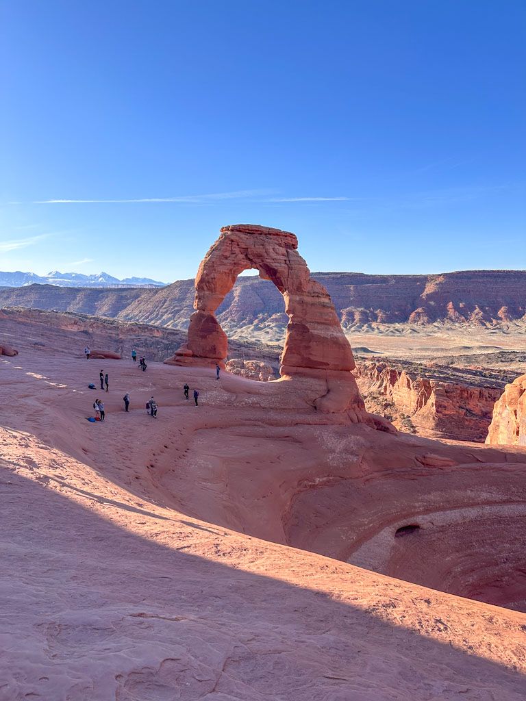
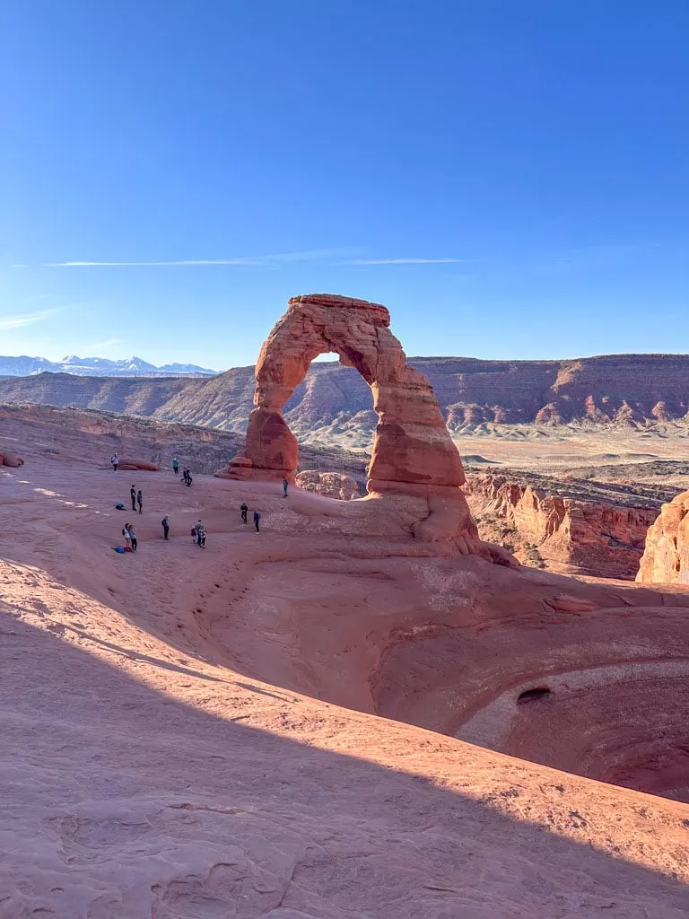
Difficulty: Moderate
Time Needed: 2 to 3 hours
Distance: 3 miles round-trip
Elevation Gain: 538 feet
Fair warning: This trail isn’t easy – it’s the hardest trail on my list. However, since it is the most popular trail in Arches National Park and most hikers (even beginners) are determined to visit it, I included it on my list.
If you bring lots of water, avoid hot weather, and go slow, this hike is doable for most people with reasonable fitness. There are lots of unprepared hikers on this trail and unfortunately, lots of rescues (especially when it’s hot out). If you aren’t sure about your ability to complete this trail, go to Delicate Arch Viewpoint instead.
The first few minutes of the trail are flat (don’t miss the detour to the petroglyph panel here), but the rest is a fairly relentless climb up a steep rock. At the end, you’ll have to walk along a wide ledge with a sharp drop-off. People who have a fear of heights may not like this trail.
You won’t get to see Delicate Arch until the very end, which is frustrating as you climb, but it makes it even more special when you finally arrive.
Pro tip: This is a popular spot for sunrise and sunset. It’s a great place to watch the sunrise. You won’t see the sunset, but it does light up the rock – the arch turns red!
Here are Google Maps driving directions to the Delicate Arch trailhead.
Sand Dune Arch
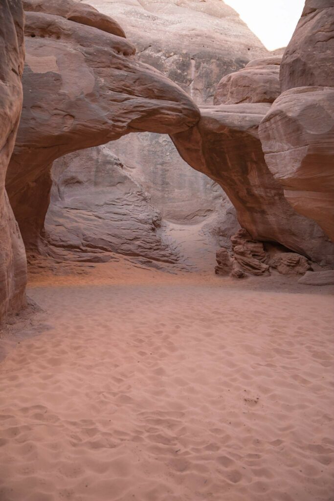

Difficulty: Super-easy
Time Needed: 15 minutes
Distance: 0.4 miles round trip
Elevation Gain: 0 feet
Sand Dune Arch is a short and easy walk from the parking lot. Although the hike is short, there are patches of deep sand, so it takes a little longer than you might think. You won’t see the arch until you get there since it is tucked away in steep rock fins.
Since this hike is so short, it’s worth combining it with the hike to Broken Arch and Tapestry Arch (below). They share a parking lot.
Here are Google Maps driving directions to the Sand Dune Arch trailhead.
Broken and Tapestry Arches

Difficulty: Easy
Time Needed: 30 to 60 minutes
Distance: 1.2 to 2.4 miles round trip
Elevation Gain: 59 to 150 feet
Broken Arch isn’t actually broken – but it does have a big crack in it that shows where it will break eventually! The trail to Broken Arch and Tapestry Arch starts at the same parking lot as Sand Dune Arch. You have a few route options. The shortest choice is to hike out and back to Broken Arch.
If you want to extend your hike, you can hike the Broken Arch Loop past Broken Arch. It includes a side trip to Tapestry Arch (one of my favourite secluded arches). Watch for markers carefully on the Tapestry Arch trail as it is less travelled.
If you are camping in Arches National Park, this is a great trail to do right from your campsite since the Broken Arch Loop goes through the campground. We did it after dinner and had it almost to ourselves.
Here are Google Maps driving directions to the Broken Arch trailhead. (It’s the same trailhead as for Sand Dune Arch.)
Landscape Arch
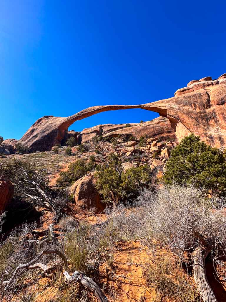

Difficulty: Easy
Time Needed: 30 to 60 minutes
Distance: 1.8 miles round-trip
Elevation Gain: 40 feet
At 306 feet across, Landscape Arch is the longest arch in North America. Until you see it in person, it’s really hard to understand just how huge it is. Photos really don’t do it justice.
Landscape Arch is located in the Devil’s Garden section of Arches National Park. Hiking the entire Devil’s Garden Trail is very challenging, but you can just do the easy first section up to Landscape Arch.
The trail winds between towering rock fins. Near the beginning, take a quick side trip to the right to visit Tunnel Arch and Pine Tree Arch. Once you reach Landscape Arch be sure to explore the various viewpoints – but stay behind the barriers as pieces of the arch can fall at any time!
Here are Google Maps driving directions to the Landscape Arch trailhead.
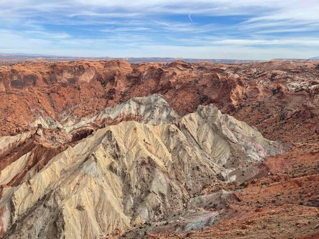
Easy Hikes in Canyonlands National Park
The Island in the Sky district of Canyonlands National Park is close to Moab and offers lots of great easy hikes. (The other districts are a few hours’ drive away.)
- Entry Fees: Entry to the park costs $30 per vehicle and is good for one week. Annual passes are also available.
- Reservations not required: While reservations are required at some times of the year at Arches National Park, you do not need a timed entry reservation for Canyonlands. The park is open 24/7 to anyone.
Mesa Arch
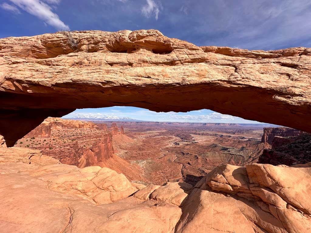
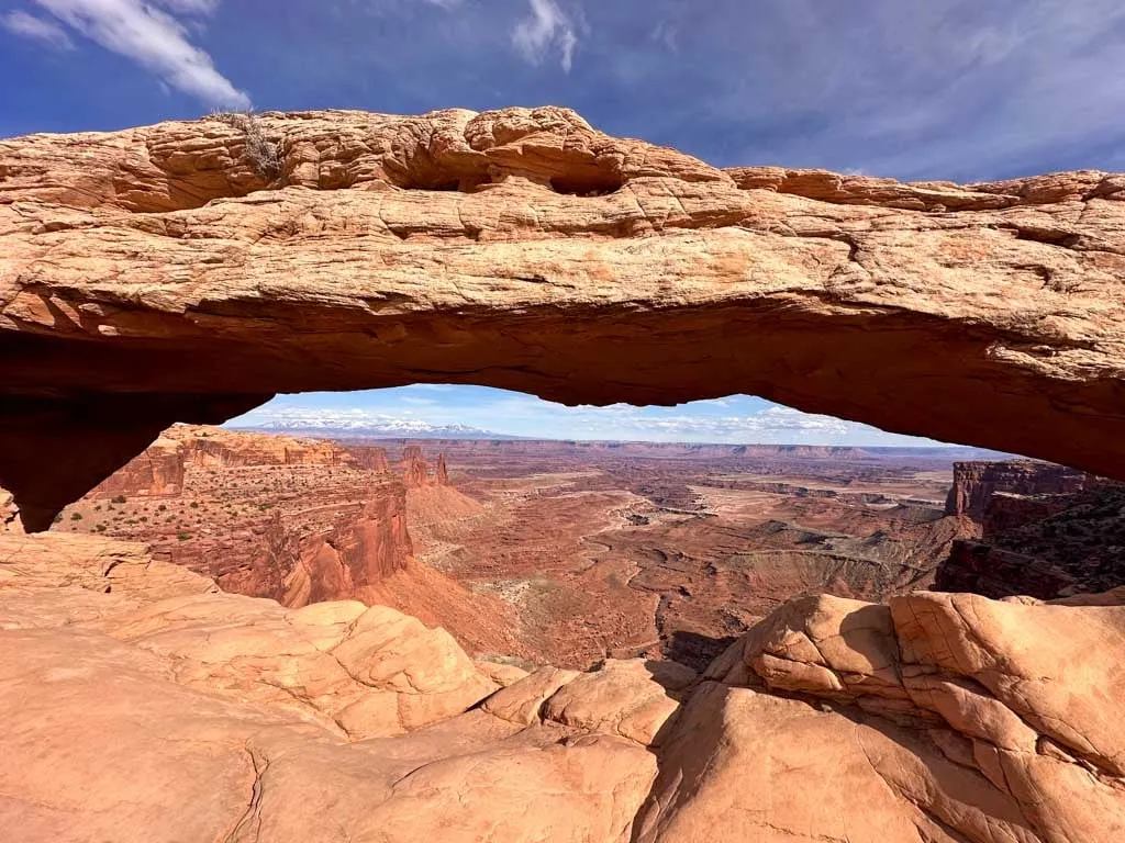
Difficulty: Super-easy
Time Needed: 30 minutes
Distance: 0.6 miles loop
Elevation Gain: 56 feet
While the arches in Arches National Park bridge gaps between rock fins, the ones in Canyonlands National Park perch on the ends of big drops. Mesa Arch sits at the edge of the Colorado River canyon. It’s a short and easy loop hike, but it does require walking up and down a rocky hill with some uneven stairs.
When you look through the arch you can see the White Rim and canyon bottom far below. You can also use the arch to frame rock pinnacles and the distant La Sal Mountains. It’s a popular sunrise spot, especially for photographers, since the sun shines under the arch.
Here are Google Maps driving directions to the Mesa Arch trailhead.
Upheaval Dome Overlook

Difficulty: Easy
Time Needed: 30 minutes
Distance: 0.6 miles round-trip
Elevation Gain: 100 feet
The hike to the Upheaval Dome Overlook is short but steep with lots of stairs. At the top, you can look down on the collapsed dome. There are also info displays explaining two possible scientific theories for how the dome formed: A meteorite impact or a salt dome.
You can also hike a little further to the Second Overlook. This adds 1 mile and 50 feet of elevation gain.
Here are Google Maps driving directions to the Upheaval Dome Overlook trailhead.
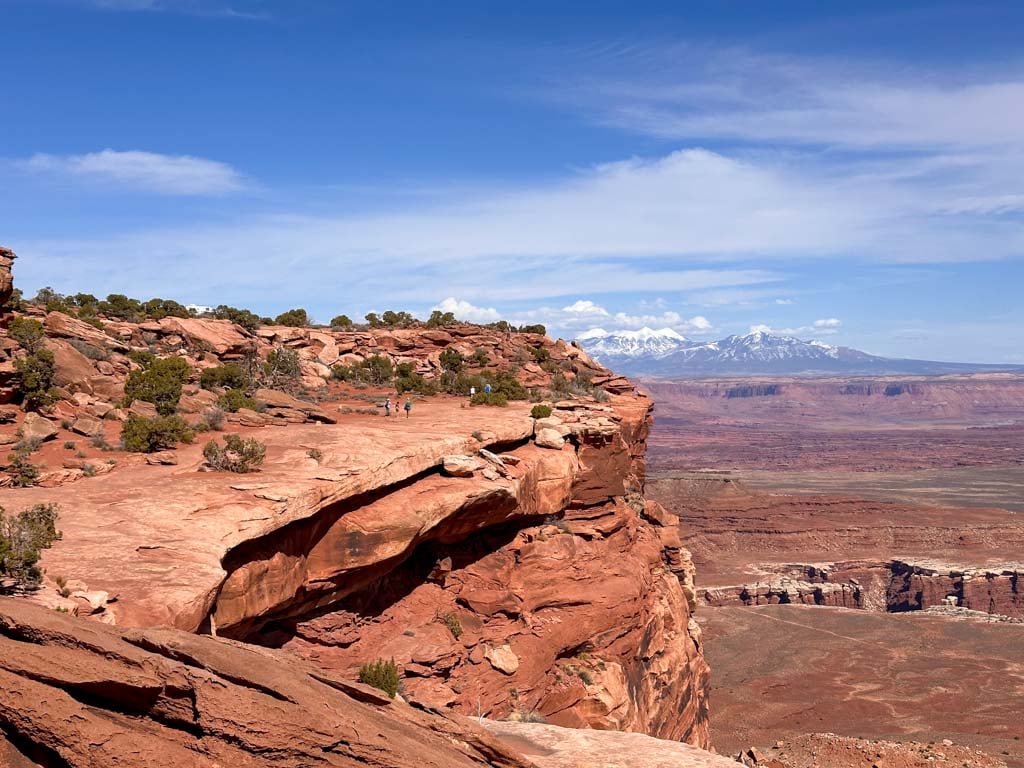
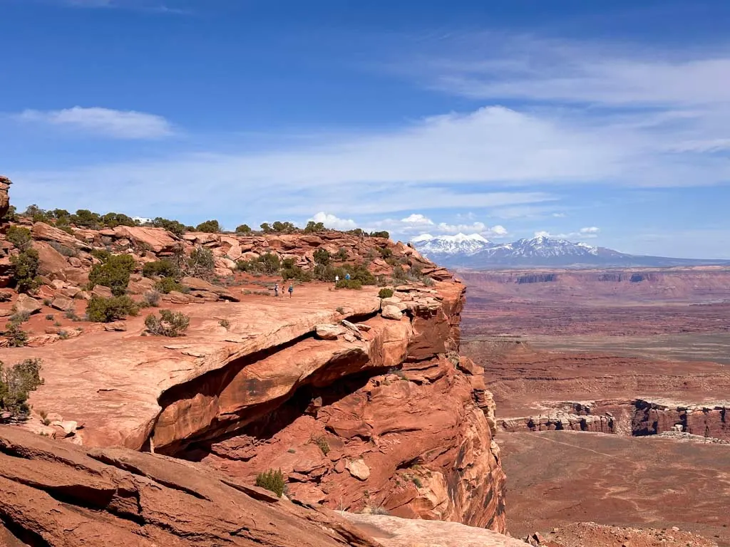
Grand View Point
Difficulty: Easy
Time Needed: 1 to 1.5 hours
Distance: 1.8 miles round trip
Elevation Gain: 73 feet
You can get a great view of the canyons of the Colorado and Green Rivers from the paved platform by the parking lot at Grand View Point. But walking the Grand View Point trail will give you an even better perspective.
The trail follows the edge of the cliff but stays far enough back that even people with a fear of heights won’t mind it. It has by far the best views in the Island in the Sky district. You can see The Maze and The Needles far across the canyon. Stunning.
Here are Google Maps driving directions to the Grand View Point trailhead.
Other Easy Hikes in Moab
There are lots of other easy hikes near Moab on BLM land or in state parks.
Mill Creek Trail
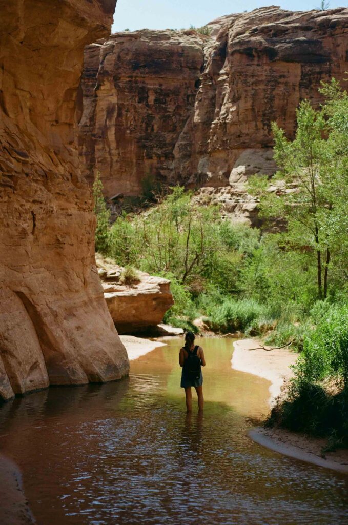

Difficulty: Easy
Time Needed: 1 hour
Distance: 1.6 miles round trip
Elevation Gain: 59 feet
Mill Creek is a great hike for a hot day. The trail follows the Mill Creek canyon upstream to a small pool below a waterfall where you can swim.
Within a few minutes of the parking lot, the trail passes an old dam and a few small pools. But continue onwards up the canyon. The trail crosses the stream multiple times so be prepared to get your feet wet. Hiking sandals are a good idea.
Your turn-around point is a pool and waterfall about 30 minutes from the trailhead. If you have more time and good route-finding skills, you can follow the trail above the waterfall up the canyon for about 3 more miles.
Here are Google Maps driving directions to the Mill Creek trailhead.
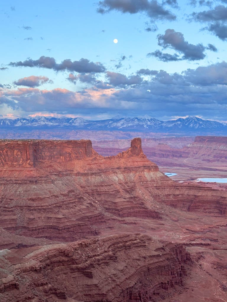
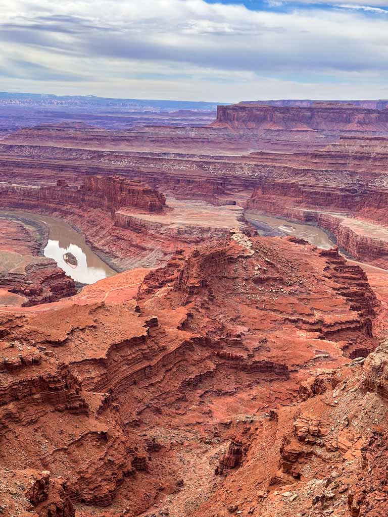
Dead Horse Point State Park

Difficulty: Easy/Moderate
Time Needed: 45 minutes to 3.5 hours
Distance: 1.2 to 6.1 miles
Elevation Gain: 65 to 630 feet
Dead Horse Point State Park occupies a spectacular mesa top with incredible views. A network of trails snakes around the edge of the mesa and gives you incredible views from the cliff tops. I actually enjoyed the views from here better than most places in Canyonlands National Park.
You have two choices for hikes: The shorter option is to do an easy 1.2-mile loop from the main viewpoint, around to the neck where you cross the road, then follow the trail on the other side back to the viewpoint.
But if you have more time, the longer 6.1-mile loop leads around the south end of the park from the viewpoint to the visitor center, then back to the viewpoint. Be sure to follow the signed side trails to great viewpoints. While the loop is long, it’s never very steep.
Heads up: Utah Parks charges $20 per vehicle per day to enter the park. Here are Google Maps driving directions to the Dead Horse State Park trailhead.
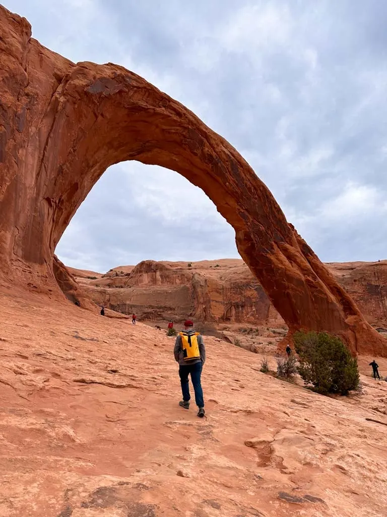
Corona Arch
Difficulty: Moderate
Time Needed: 2 to 3 hours
Distance: 2.3 to 3.5 miles
Elevation Gain: 462 to 765 feet
Corona Arch is a great short hike near Moab that leads to a spectacular arch, nicknamed Little Rainbow Bridge. The trail climbs up above a canyon to a sandy area. At a fork, you can go left on a spur trail to Pinto Arch or continue straight toward Corona Arch. (I recommend doing Pinto Arch on the way back if you have the energy.)
From the fork, the trail climbs up over slickrock. There is one section with a chain and stairs carved out of the rock and then a ladder. But it is fairly straightforward and most people won’t struggle here. After the ladder, you’ll pass Bowtie Arch and then arrive at Corona Arch.
Here are Google Maps driving directions to the Corona Arch trailhead.
Moab Hiking Tips
Park Entry Fees
You will need to pay park entry fees for most of the easy hikes in Moab.
Arches National Park: $30 per vehicle per week
Canyonlands National Park: $30 per vehicle per week
Dead Horse State Park: $20 per vehicle per day
There are no fees to hike anywhere else in Moab outside of these parks.
Pro tip: If you plan to visit both Arches and Canyonlands Parks, you can buy a Southeast Utah Annual Pass that covers both parks and is a bit cheaper. Or you can buy an America the Beautiful Pass that covers all National Parks for a year.
National Park Reservations
Between April 1 and October 31, visitors entering Arches National Park between 7 am and 4 pm need to make a reservation for a timed entry ticket. (You don’t need a reservation at other times.)
You do NOT need reservations for Canyonlands National Park or Dead Horse Point State Park.
Weather in Moab
Moab is in the desert so it is blazing hot in the summer and chilly in the winter. In general, spring and fall are the best times to hike in Moab since the weather is just right – not too hot or too cold. It also rarely rains all-year – about 3 days a month.
The chart below has Moab’s average high and low temperatures for each month. The temperature plummets at night so the average lows are nighttime temps.
| Month | Average High | Average Low |
|---|---|---|
| January | 44°F | 20°F |
| February | 52°F | 26°F |
| March | 64°F | 35°F |
| April | 73°F | 42°F |
| May | 83°F | 50°F |
| June | 95°F | 58°F |
| July | 100°F | 65°F |
| August | 97°F | 64°F |
| September | 88°F | 54°F |
| October | 74°F | 41°F |
| November | 58°F | 30°F |
| December | 45°F | 22°F |
In Mob, it’s always a good idea to start your hike early in the day to beat the heat and the sun. Avoid hiking if it’s over 90°F – it can be dangerous. Every year people suffering from dehydration or heat exhaustion need to be rescued. Read my tips for hiking in hot weather before you go.
What to Bring Hiking in Moab
It’s important to stay hydrated. The National Parks Service recommends drinking 4L (one gallon) of water per person per day. It’s a lot of water, but since it’s so hot and dry here, you’ll need it. You can get water at Park Visitor Centres and campgrounds.
You also need to protect yourself from the sun. Bring a wide-brimmed hat, sunglasses, and sunscreen. I also like to cover up in a long-sleeved sun hoodie. The fabric provides sun protection so I don’t have to worry about reapplying sunscreen! My guide to the best sun hoodies for hiking has six great options.
And just like on any other hike, you need to bring the 10 essentials. These are key safety items you need on the trail including food, a first aid kit, etc.
If you plan to do a sunrise or sunset hike, pack a headlamp or flashlight for each person. Make sure your batteries are fully charged!
For lots more advice, check out my tips for hiking in the desert.

Hiking with Dogs in Moab
Dogs aren’t allowed on hikes in Arches or Canyonlands National Parks.
In Dead Horse Point State Park, dogs are allowed on trails but they must be on a six-foot leash.
Dogs are also allowed on leash at Corona Arch, but some dogs will struggle with the slick rock and the ladder section. You can also take your dog on the Mill Creek Trail.
Drones
Drones are not allowed in Canyonlands or Arches National Parks. In Dead Horse State Park drones are allowed from November to February by permit only. Drones are prohibited the rest of the year and are never allowed at the main Dead Horse Point viewpoint.
Stay Off the Arches
It is illegal to walk on top of the arches in Canylonands and Arches National Parks. It’s also pretty dangerous since rocks can fall at any time! In the 1990s, huge sections of Landscape Arch fell into a visitor viewing area. Thankfully no one was hurt, but now that area is closed.
Leave No Trace
Learn the Leave No Trace principles before you hike in Moab. This is a sensitive desert ecosystem. Pack out all your trash. Use toilets at trailheads before you hike. If you have to go on the trail, bring a WAG bag to pack our your poop.
One of the most important things to remember is to stay on the trail so you don’t Bust the Crust. The fragile biological soil crust here is alive and a single footstep can destroy it for decades.
Indigenous Context
The Moab area is the traditional territory of the Diné Bikéyah (Navajo), Núu-agha-tʉvʉ-pʉ̱ (Ute), and Timpanogos. It’s important to be respectful of this land.
If you’re looking for an easy hike in Moab, you’ll find one on this list. What’s your favourite short trail in Moab? Tell me in the comments.
READ NEXT:
- Tips and Tricks for Hiking in the Desert
- Tips for Hiking in Hot Weather
- Best Sun Hoodies for Hiking
- Take an Epic Outdoors Arizona Road Trip
- 14 Best Outdoor Activities Near Las Vegas


- Best Sun Hoodies for Hiking - June 3, 2026
- Lower Stein Valley Trail Hiking and Backpacking Guide - May 27, 2026
- The Best Things to Do in Vernon, BC - May 21, 2026