
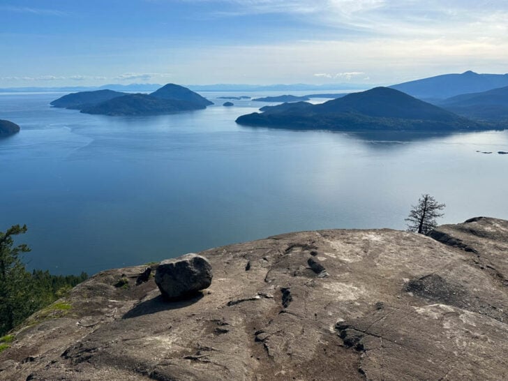

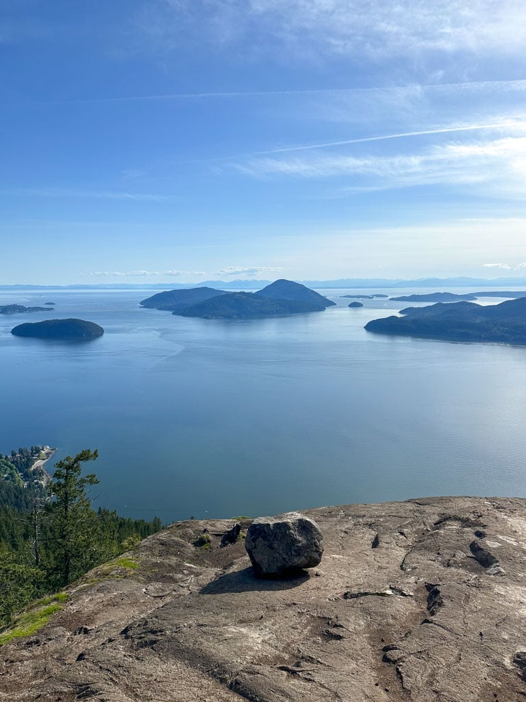
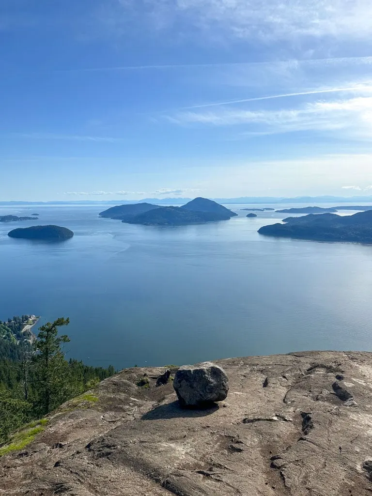
The view from Tunnel Bluffs in Lions Bay is spectacular. The hike takes you to an open bluff with an incredible view of Howe Sound. As a Squamish local, I’ve hiked all over the Sea to Sky area, and I think the Tunnel Bluffs hike has one of the best views around.
I’ve hiked this trail a few times, so I’ve put together a complete Tunnel Bluffs trail guide for you. It has everything you need to know about finding the current trailhead (it moved!) and navigating the trail.
This Tunnel Bluffs trail guide includes:
- Key trail stats for the hike to Tunnel Bluffs
- A Tunnel Bluffs trail map and elevation profile
- How to get to the trailhead by car or bus and details on where to park
- Turn-by-turn hiking directions with lots of photos
- Info on camping at Tunnel Bluffs (spoiler – it’s not allowed)
- Why is it called Tunnel Bluffs? The story behind the name
- Tunnel Bluffs Hike FAQ – all your questions answered
This is a sensitive wilderness area. Learn how to Leave No Trace to keep the wilderness wild. Make sure you are prepared by bringing the 10 Essentials. Get ready for adventure with this checklist of things to do before every hike.
Hey there: Some of the links in this post are affiliate links, which means I earn a small commission at no cost to you. Thanks for your support. -Taryn
Tunnel Bluffs Hike Basics
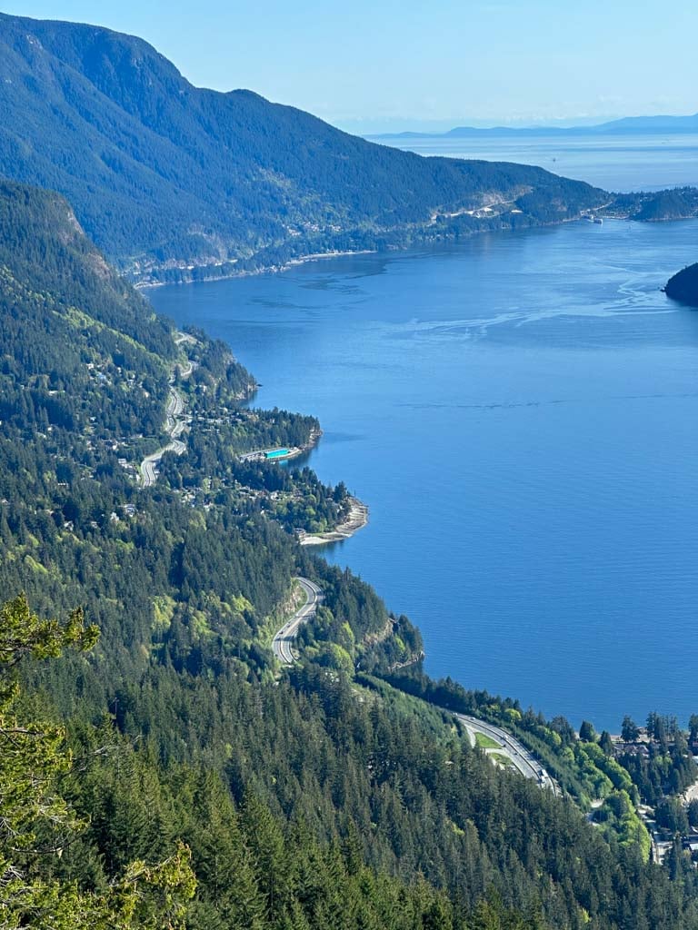
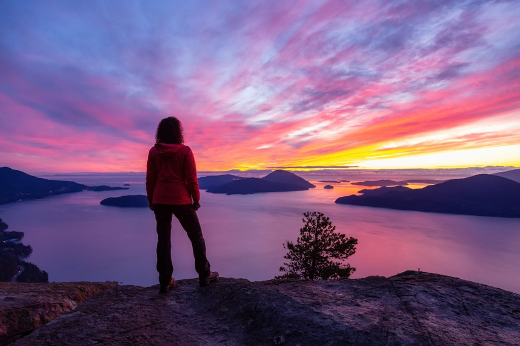
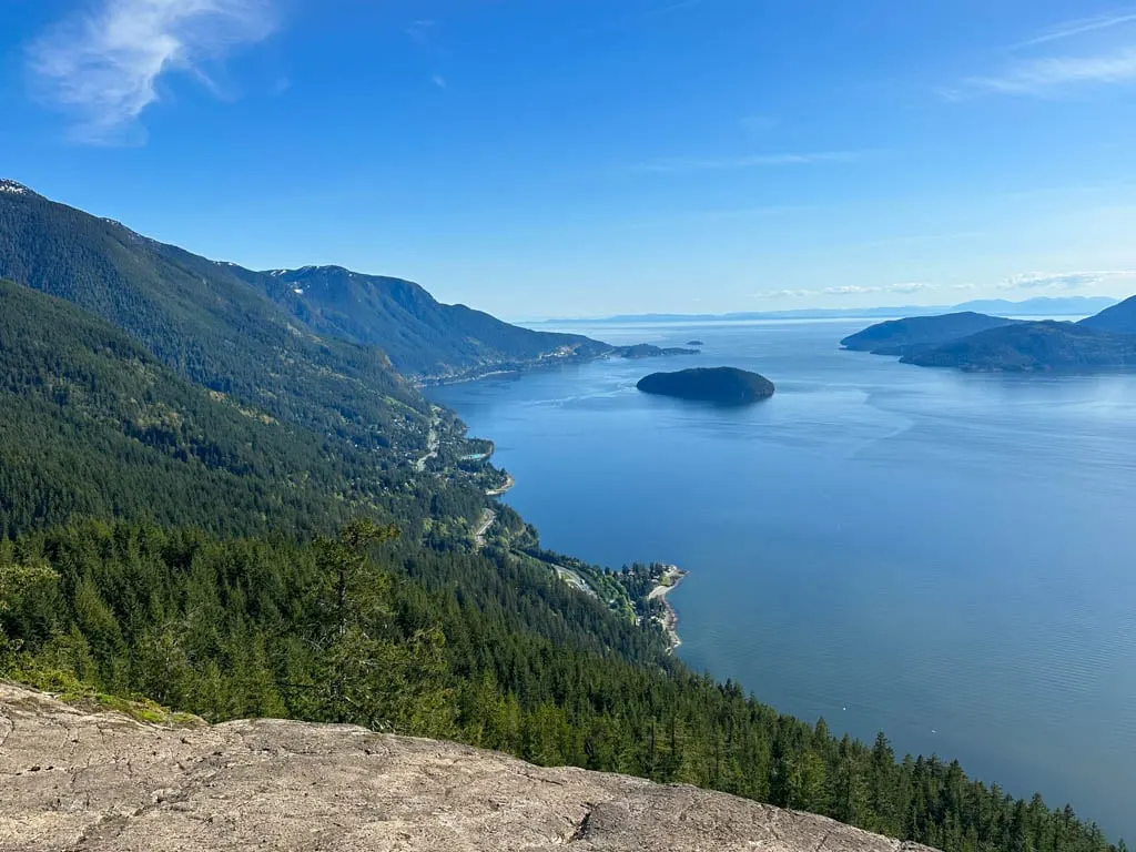
Tunnel Bluffs is a spectacular viewpoint on a bluff above Howe Sound. It’s a popular spot for sunset since it faces west – you can watch the sunset over the ocean and islands. It’s an Instagram favourite since the views are so spectacular.
The trailhead in Lions Bay is easy to reach by car or bus (although parking is a bit complicated and can be expensive – more details on that below.) The trail is easy to follow as long as you read the signs at each junction. The hike has a steep first half and an easy and nearly flat second half, so overall, I would give it a moderate rating.
The Tunnel Bluffs trail is located on the traditional territory of the Sḵwx̱wú7mesh Úxwumixw (Squamish). To learn more about the Indigenous context of the area, visit the Squamish Lil’wat Cultural Centre in Whistler. Online resources include the Squamish Nation website and the Squamish Atlas.
Important Note: The trailhead for Tunnel Bluffs is on Sunset Drive in Lions Bay. There is an older trailhead on Highway 99 that is now closed. This trail guide has directions for the Lions Bay trailhead since that is the only place you can start the hike now.
Trail Stats
Distance: 11 km round trip
Elevation Gain: 450 m
Duration: 3.5-4.5 hours
Difficulty: Moderate
Season: March to November
Toilets: At the trailhead
Dogs: Allowed off-leash
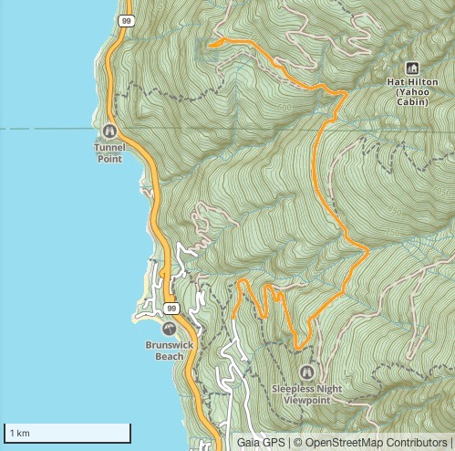
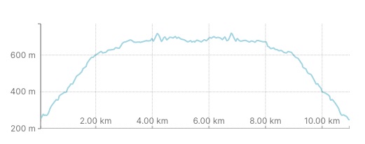
Tunnel Bluffs Trail Map
I made a map and elevation profile of the Tunnel Bluffs Trail for you using Gaia GPS, my favourite GPS and mapping app. Click through to zoom in.

How to Get to the Tunnel Bluffs Trail
You can get to Tunnel Bluffs by car and by bus on public transit. But it can be a bit confusing to navigate in Lions Bay or figure out where the trailhead is now. (It used to be somewhere else!) In this section, I’ve got everything you need to know for driving, parking, and taking the bus to the Tunnel Bluffs trail.
Where is the Trailhead for the Tunnel Bluffs Hike?
The current trailhead for Tunnel Bluffs is on Sunset Drive in the Village of Lions Bay. There is an old trailhead on Highway 99 at Tunnel Point. However, in March 2020 new 30-minute parking restrictions and no-parking zones went into effect that made it impossible to park there to start the hike. As well, you had to cross the Highway from the parking lot to the trailhead, which was really dangerous.
Now, the only way to hike to Tunnel Bluffs is to start at Sunset Drive in Lions Bay. It is a much safer and easier place to get to. Below I’ve got both driving and public transit directions for getting to the trailhead.
Driving Directions for the Tunnel Bluffs Hike
From Vancouver, head over the Lions Gate Bridge, then go west on Highway 1. Follow the signs to switch to Highway 99 North before Horseshoe Bay. In Lions Bay, take the Lions Bay Avenue exit off the Highway.
The streets in Lions Bay can be a bit confusing, so I find it easiest to put “Sunset Trailhead Public Pay Parking” into Google Maps, then follow my GPS.
After getting off the highway, follow the road up the hill, then turn left onto Crosscreek Road and cross the bridge. At the stop sign, turn right onto Centre Road and go uphill past the fire hall. At the next intersection go left onto Bayview Road. Stay on Bayview, passing over several sections of speed bumps in front of the school then going uphill around a few curves.
At a T-junction, turn left onto Mountain Drive. Keep going uphill to another T-junction. Turn left onto Sunset Drive. The parking lot and trailhead are at the end of this road. Click here for Google Maps driving directions.
Parking in Lions Bay
Lions Bay is a small community and unfortunately, they are not that welcoming to hikers. In 2021, Lions Bay implemented pay parking everywhere in the village, along with tons of no-parking zones. They are very strict with their parking regulations so make sure you pay for parking and park in approved areas or you risk getting ticketed towed. Read more about parking in Lions Bay.
You can pay for parking at a kiosk at the Sunset trailhead or using the Flowbird App. Cell service in Lions Bay isn’t great, so download the app and make an account before you get there.
The best place to park for the Tunnel Bluffs hike is the parking lot on Sunset Drive. However, there are only about 15 parking spots, and they fill up fast. Parking here costs $3/hour ($24 max per day) with a 3-day maximum.
The next closest place to park is street parking on the east side of Mountain Drive. Read the parking regulations signs carefully to be sure that you are parked legally. Parking is $2/hour here and you can pay via the Flowbird app or at the meter at the corner of Bayview Road and Mountain Drive. Parking here will add 0.5-1 km and 40 m of elevation gain each way to your hike.
During the summer and on the weekends you can park for free at the lower lot at Lions Bay Elementary School on Bayview Road. Parking here will add 1 km and 120 m of elevation gain each way to your hike.
How to get to the Tunnel Bluffs Hike on the Bus
Tunnel Bluffs is a great public transit-accessible hike. From downtown Vancouver, take the 257 or 250 bus to Horseshoe Bay. Transfer to the 262 bus to Lions Bay. Get off the bus on Crosscreek Road at Oceanview Road in Lions Bay. From here, turn right on Centre Road, then walk up Bayview Road, following the driving directions above. Taking the bus will add 1.8 km and 160 m of elevation gain each way to your hike.
Tunnel Bluffs Hiking Directions
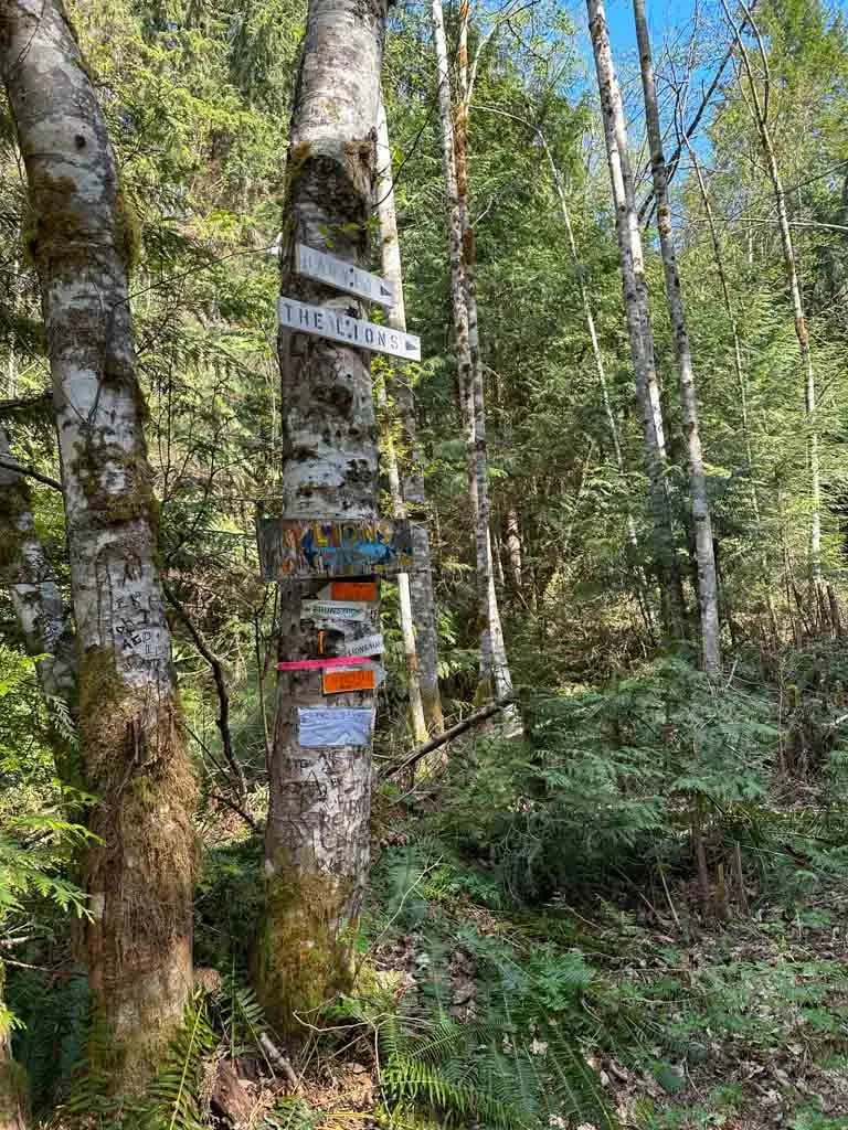
The trail to Tunnel Bluffs is fairly easy to follow with signs at every junction. However, the signs are all homemade and can be hard to spot, so pay attention as you hike. There are also kilometre markers on the trees to mark your progress.
The trail starts at the end of the parking lot on Sunset Drive. Walk past the info kiosk and pit toilets and around the gate onto a wide gravel road.
The first half of your hike will be on this road as it snakes uphill. There is no escaping it – the beginning of this hike is really steep. You will gain 350 m in 2 km. This section of the hike is also fairly boring as it is on a wide road with no views.
From the trailhead, follow the old road uphill as it curls to the right around the first switchback past a water tank. If you watch closely, you will see the Missing Link Trail leaving the road on the right, then the Harrison Trail on the left. Ignore both of these trails and stay on the main gravel road.
A few minutes later the road curls back to the left. Stay on the road and keep climbing. At the 1 km mark, the trail forks. Stay right as the road to the left goes to a locked fence. A few minutes later, the road curls through two more tight switchbacks, then heads south and continues uphill.
Round one curve as the road starts back north, then arrive at a major junction at the 2 km mark. Stop to catch your breath as you have finished the bulk of the elevation gain – the rest of the hike is much flatter!

Go left at the junction to continue towards Tunnel Bluffs. The road to the right leads to the Lions. Shortly after the junction, cross a small stream by hopping across the rocks. It dries up to a trickle in summer.
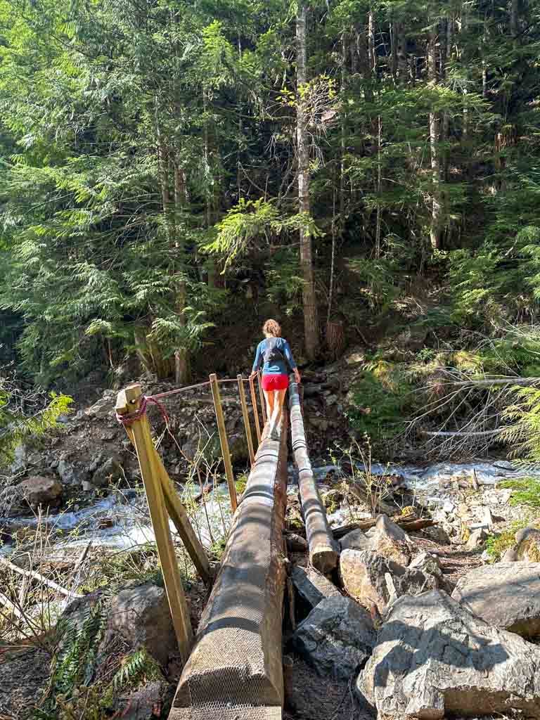
About 2.7 km from the trailhead, arrive at a log bridge over Magnesia Creek. It should take about 40 minutes to 1 hour to hike this far.

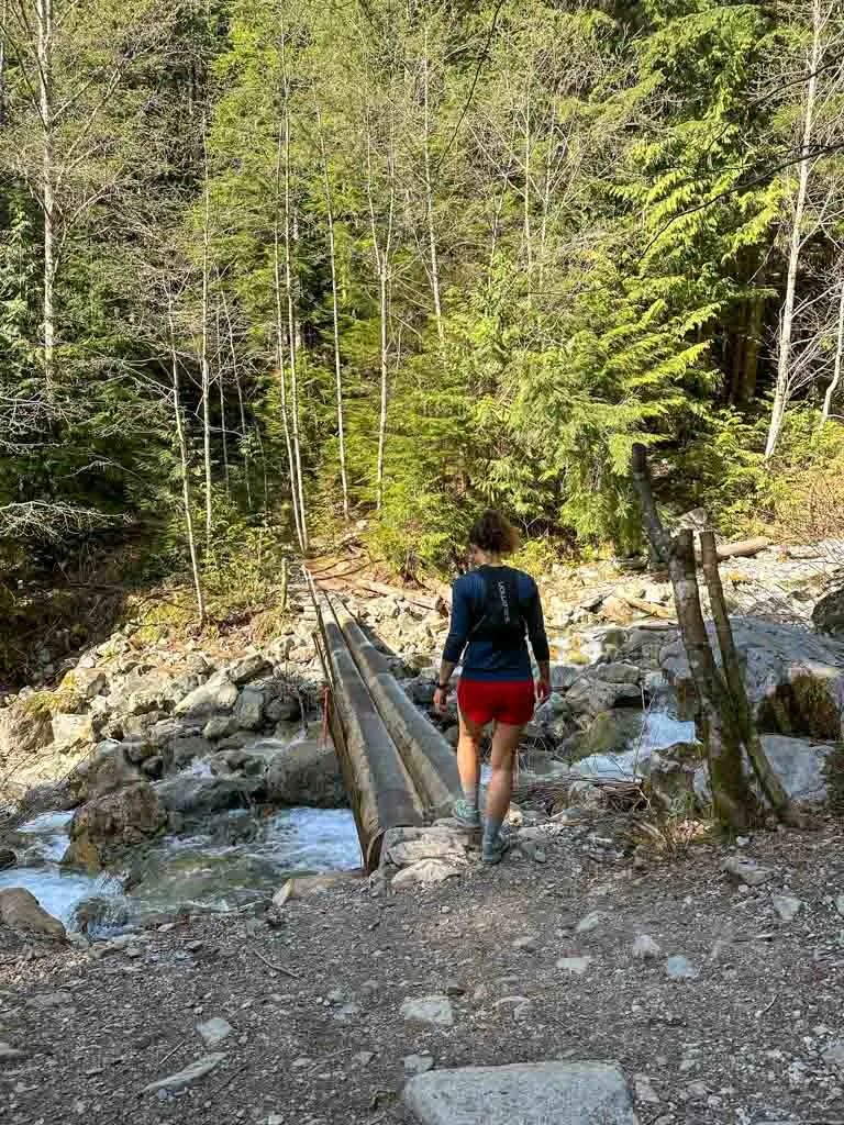
The bridge is made of two logs with wire decking for grip. It has a rope handrail for balance. Some hikers may find this bridge (and the one that comes later) a little intimidating, but most will find crossing it a fun adventure. The logs can be a little bouncy, but they are wide and secure. Go one at a time if you are nervous.
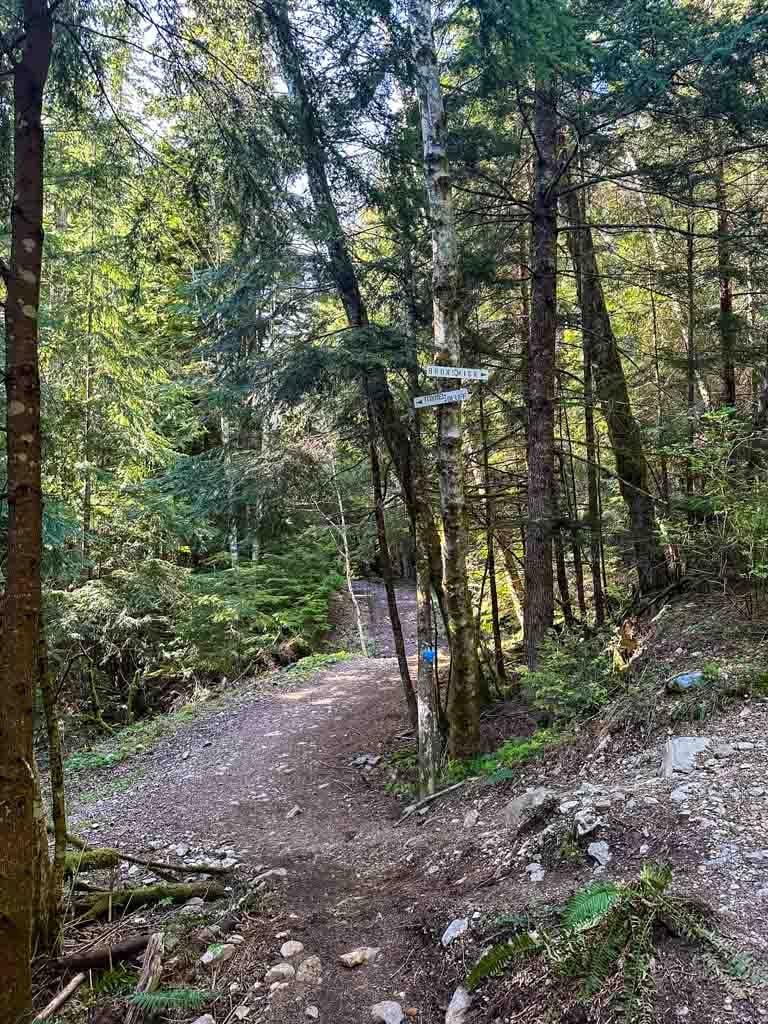
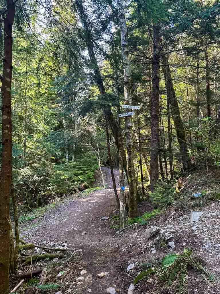
The old road you have been hiking on starts to look a bit more like a trail, but it is still fairly wide. A few hundred meters after the bridge, near the 3 km mark, arrive at another junction. Signs on the trees point the way to Tunnel Bluffs on the left along the old road. The route to the right is the steep trail to the summit of Brunswick Mountain.
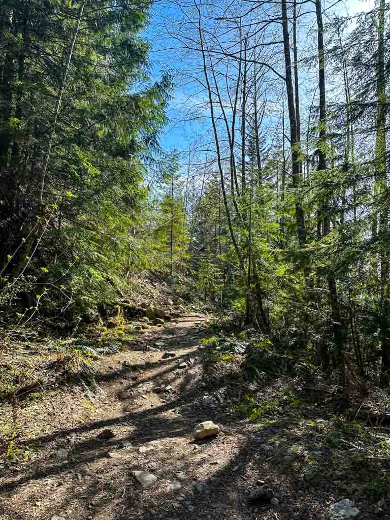
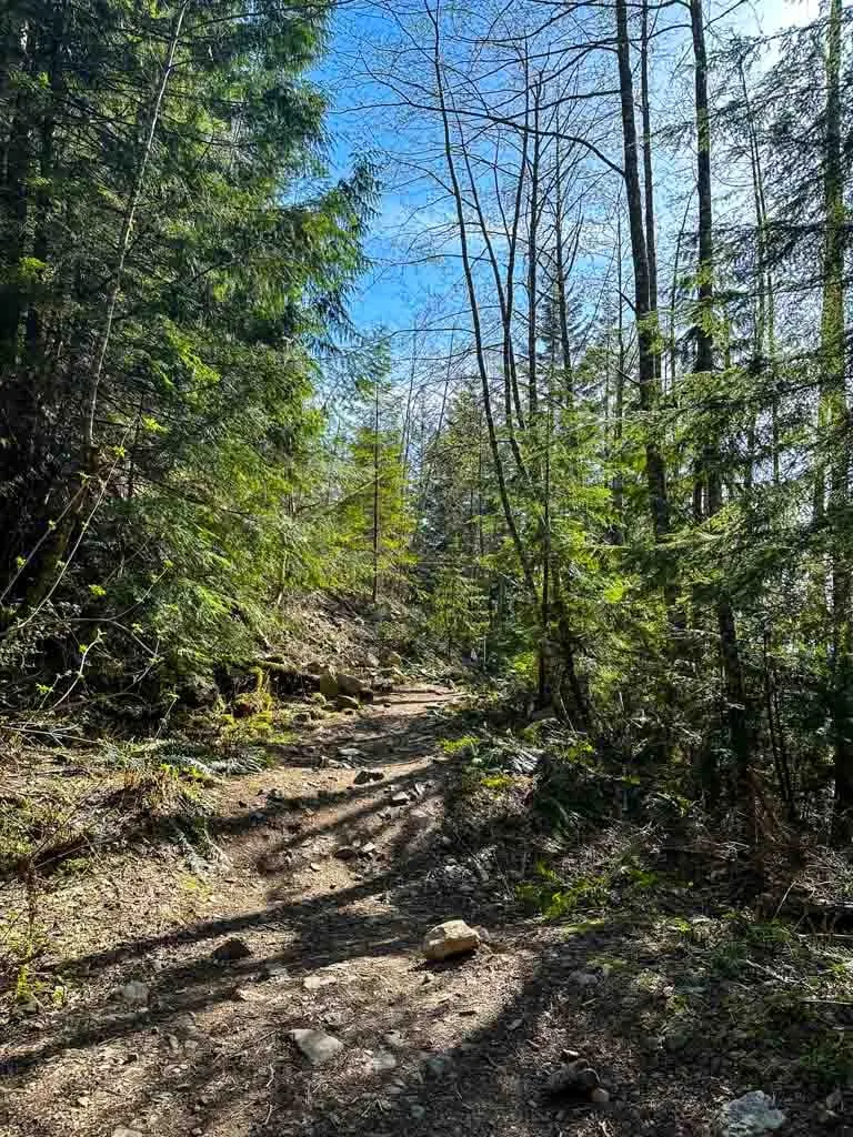
Keep hiking along the road, which looks more and more like a trail as the trees grow in on the sides. At one point the trail gets rocky as it crosses below a scree slope.
Near the 4 km mark, reach a log bridge over M Creek, also known as Yahoo Creek. This bridge has the same construction as the first.
About half a kilometre later, stay on the road old, ignoring an overgrown trail dropping down to your left. An info sign and map here mark the start of the old Tunnel Bluffs Trail that comes up from the highway. It has fallen into disuse now that parking restrictions on the highway prevent hikers from coming up that way.

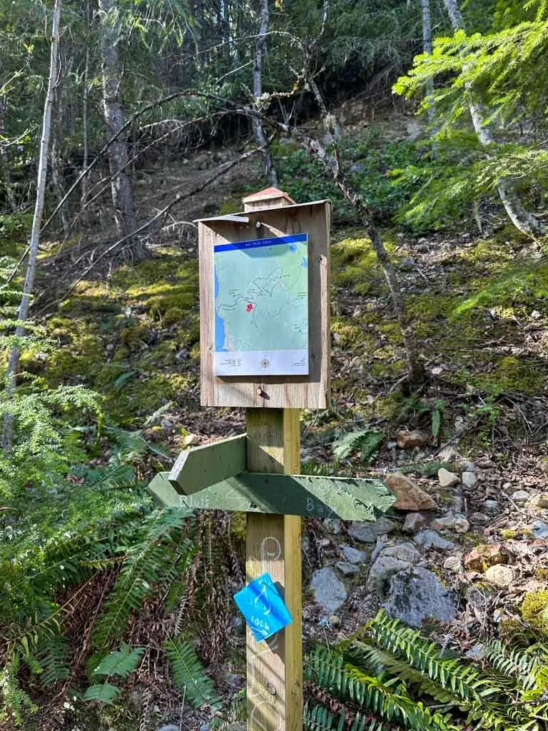
A few minutes after that, reach another junction. The Hat Mountain Trail heads uphill to the right. Follow the Tunnel Bluffs Trail straight.
A few minutes later the trail leaves the old road bed and heads left towards the ocean. This is the only part of the route that is not on an old road, so it is much narrower and rockier. The path is obvious as you scramble up a short rock outcropping, then find yourself at the top of the bluff.
The view from the top is spectacular, but it’s even better further down. Work your way down the left (south) side of the bluff, using whichever route seems easiest to you. At the bottom, a wide flat area makes a great spot to take a break and enjoy the view.

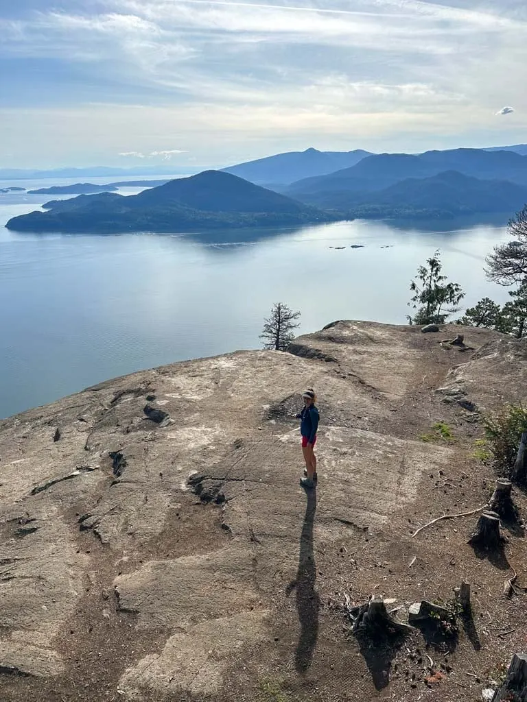
You can see the Sea to Sky Highway stretching down the coast to the south to Horseshoe Bay. The bigger islands in Howe Sound are Bowen Island to the southwest and Gambier Island to the west. You can also see Keats Island behind Bowen and the Gibsons area of the Sunshine Coast. Around the corner to your right, you can also see Anvil Island. The tiny rock islands in front of Gambier are called Seal Rocks.

There is a wooden box attached to a tree with a log book in a drawer that you can sign. Please resist the temptation to leave anything in the box – pack out all your garbage with you.
After you have enjoyed the view (perhaps at sunset), retrace your steps back to the trailhead. Take care on the steep descent through the switchbacks as some of the rocks are quite loose.

Camping at Tunnel Bluffs
While you may have seen photos of people camping at Tunnel Bluffs, unfortunately, it is not officially allowed. There is no toilet here and the area is very rocky, so camping leads to a disgusting build-up of human waste. In the past, campers have started campfires that got out of control. Enjoy the area at sunset (or any time of day), but don’t stay overnight.
Why is it Called Tunnel Bluffs?
There are no tunnels at Tunnel Bluffs – just an amazing view. The bluffs are named for Tunnel Point, the area just below it on Highway 99. (The parking area and viewpoint at Tunnel Point is where the old trail to Tunnel Bluffs starts.) Tunnel Point got its name because there is a train tunnel that runs through it (and actually goes under the highway in that area).
Tunnel Bluffs Hike FAQ
Yes. The trail to Tunnel Bluffs from Sunset Drive in Lions Bay is open. It is usually snow-free from March to November. The old trail to Tunnel Bluffs from Tunnel Point on Highway 99 is closed.
Yes. You can take the 262 bus to Lions Bay from Horseshoe Bay, then walk up the road to the trailhead. I’ve got public transit directions in the getting there section above.
The best place to park is the parking lot at the end of Sunset Drive in Lions Bay. However, it fills up fast. I’ve got alternative parking locations in the getting there section, above.
The hike is 11 km round trip, and will take 3.5 to 4.5 hours.
No. Camping is not allowed (even though there are lots of photos of people camping there on social media).
The Tunnel Bluffs hike is moderate. The first half of the hike is quite tough as it goes uphill very steeply on a rocky trail. The second half is nearly flat.
The hike starts at the end of Sunset Drive in the village of Lions Bay.
The trail to Tunnel Bluffs is usually snow-free between March and November. You can hike to Tunnel Bluffs in winter, but you may need microspikes or snowshoes, depending on snow conditions. As well, the trail passes through and below avalanche terrain, so you need to have avalanche training and understand the avalanche forecast.
There are toilets at the trailhead, but there are no toilets anywhere else on the hike. The beginning of the hike is the watershed for Lions Bay’s drinking water, so please do not go to the bathroom in that area.
Dogs are allowed off-leash (and under control) on this hike. However, two log bridges on the trail may be a challenge for some dogs. See the photos above to decide if this is a good hike for your dog.
Yes. Tunnel Bluffs faces southwest and is one of the best sunset hikes near Vancouver.
No. Tunnel Bluffs doesn’t face the sunrise (it faces southwest, not east) so it is not a good hike to see the sunrise since it will be behind you on the other side of the mountain.
No. In the past, hikers’ campfires have started wildfires here. It is a very dry area and the risk of forest fire is very high. Unfortunately, previous hikers have made campfires so there are some old fire pits in the area – do not use them. People have also cut down live trees nearby for firewood, which is sad to see.

Now you have all the info you need to hike to Tunnel Bluffs in Lions Bay. Do you have questions about the trail or how to get there? Ask them in the comments – I’m happy to help!
READ NEXT:
- The Best Hikes in Squamish, BC (From a Local)
- Sea to Sky Highway Road Trip Guide: Driving from Vancouver to Whistler
- 70+ Things to Do in Squamish
- The Best Hikes in Whistler: A Guide to All the Trails
- Alternatives to the Grouse Grind: Steep Workout Hikes Near Vancouver


- Best Sun Hoodies for Hiking - June 3, 2026
- Lower Stein Valley Trail Hiking and Backpacking Guide - May 27, 2026
- The Best Things to Do in Vernon, BC - May 21, 2026
Hana
Monday 15th of July 2024
Thank you, Taryn, for this very detailed information and photos. So incredibly helpful!
Hannah
Saturday 4th of May 2024
Hello! I’m looking to do the trail next weekend, would you recommend bear spray for this trail?
Taryn Eyton
Monday 6th of May 2024
I would recommend bear spray for any trail in this area in the spring. The bears have recently woken up and are looking for food. It's still snowy up high so the bears are lower down the mountain (in this area) right now.