

The hike to the Big Cedar and Kennedy Falls in North Vancouver is one of my favourite local hikes. Since it’s at a fairly low elevation, it’s a great hike almost all year since it doesn’t get much snow. And it’s entirely in the trees, making it a great hike for a rainy or cloudy day. The temperate rainforest scenery is gorgeous by itself, but the standout features of the hike are a visit to a 600-year-old cedar tree and gorgeous Kennedy Falls. In this guide, I’ve got everything you need to know to hike the trail including directions for multiple trailheads, parking, and safety info.
This is a sensitive wilderness area. Learn how to Leave No Trace to keep the wilderness wild. Make sure you are prepared by bringing the 10 Essentials. Get ready for adventure with this checklist of things to do before every hike.
Big Cedar and Kennedy Falls Trail Overview
Distance: 10km return from the Mount Fromme parking lot, 12km from street parking, 13km return from Lynn Headwaters parking lot, 11.5km loop with a creek crossing
Elevation Gain: 150m from Mount Fromme parking, 300m from street parking, Lynn Headwaters parking or via loop route
Difficulty: Moderate. While the stats may make this sound like an easy trail, it’s quite rugged and the terrain is challenging. Keep an eye out for trail markers the entire hike to make sure you stay on track.
Time: 5-6 hours
When to Go: You can hike this trail all year as it rarely has snow. However, from November to March be prepared to encounter icy conditions or a bit of snow.
Resources: A map or GPS app can be really helpful on this hike as many people have gotten lost here. My favourite map is the Trail Ventures BC North Shore Trail Map.
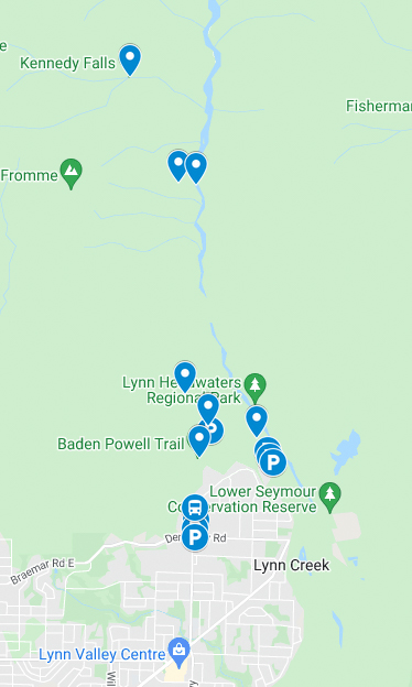
Map: I made a custom Google map for you. It shows all the parking locations and trailheads. Just FYI it doesn’t have all the trails so you can’t use it to navigate on your hike. Plus there’s no cell service for most of the hike anyway.

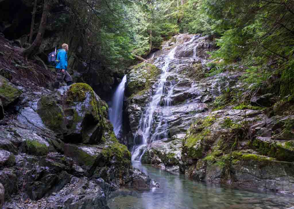
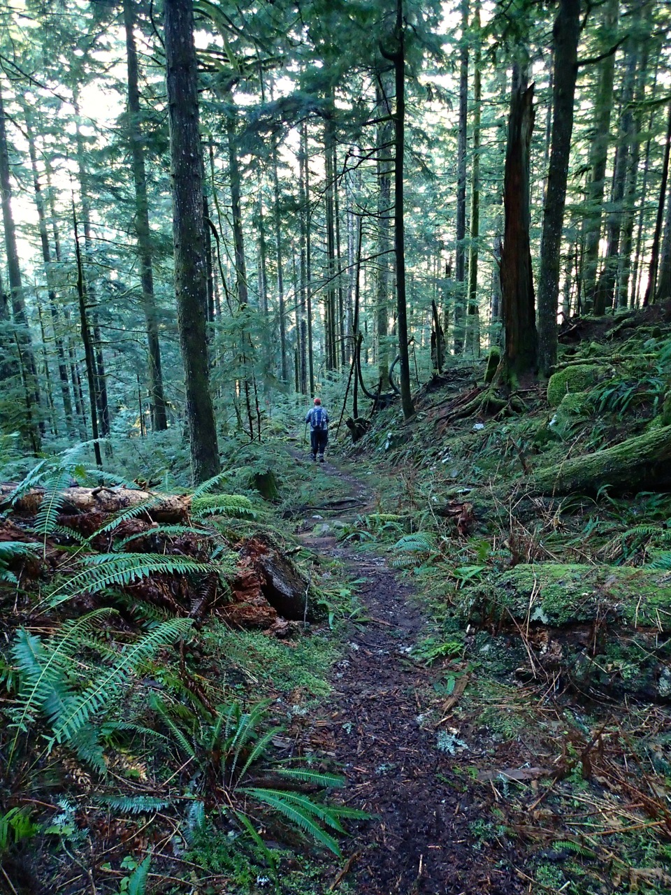
Unlike most trails on the North Shore, the trail to the Big Cedar and Kennedy Falls isn’t straight up a mountain. However, it’s still a pretty challenging hike in rugged terrain. It follows an old logging road through the forest and can be very slippery and muddy. There are also a few unbridged creeks to cross. The highlights of the trail are the Big Cedar, a giant cedar tree that is over 600 years old, and beautiful Kennedy Falls.
The conventional way to hike to Kennedy Falls is as an out-and-back hike from the Mount Fromme parking lot. But it’s also possible to park in a couple of other locations or to make a loop hike. I’ll give you details on all the options below, plus full details on what to expect when you hike this trail.

Big Cedar and Kennedy Falls Driving Directions and Parking
There are three different places to start the hike to the Big Cedar and Kennedy Falls. The usual place to start the hike is from the Mount Fromme parking lot. However, this lot is very busy and doesn’t have very much parking so it often fills up. It can be easier to plan to park on the street or to park in Lynn Headwaters Regional Park and hike from there.
Mount Fromme Parking Lot
If you park at the Mount Fromme parking lot you’ll have the shortest hike into the Big Cedar and Kennedy Falls with the least elevation gain. However, the Mount Fromme parking lot is VERY busy since it’s a popular starting point for mountain biking. As well, the majority of the spots in the lot only allow you to park for 3 hours, which isn’t long enough to do this hike. If you want to park here, come on a weekday or early in the morning. It’s also worth noting that the lot is gated so make sure you don’t get locked in. Current hours are posted at the gate, but they are typically 9 pm in summer and 6 pm in winter.
To get to the Mount Fromme Parking lot, from Highway 1 take exit 21 onto Mountain Highway. Go north (uphill) on Mountain Highway for 4.5km. Mountain Highway will narrow and pass through a yellow gate beside a sign that says “Fromme”. Continue on the road as it turns to gravel. In about 500m turn right into the parking lot. The trailhead is on the gravel road just past the turn off for the parking lot. Click here for driving directions.
Street Parking
Since the Mount Fromme parking lot is often full, many people end up parking on the street in the nearby neighbourhood. This is a nuisance for locals so there is a resident-only parking zone on the streets closest to the trailhead. As well, many streets have 2-hour parking signs, which isn’t enough time to finish the hike. The only places you can legally park on the street are about 1km of walking and up to 150m of elevation below the parking lot.
To find legal street parking, take exit 21 from Highway 1 onto Mountain Highway. Head north on Mountain Highway for about 4km. Your best bets for legal street parking are on the side streets. Mill Street is the closest place you can park to the trailhead. But you can also find parking on Evelyn Street and Dempsey Road. From wherever you find parking, head back to Mountain Highway, then walk up the hill along Mountain Highway to the trailhead. Click here for driving directions.
Lynn Headwaters Parking
I actually prefer to park at Lynn Headwaters for this hike. It’s easier to find parking and the extra walk to the trailhead is on trails rather than sidewalks. To get to the Lynn Headwaters parking lot, take exit 21 from Highway 1 onto Mountain Highway. Head uphill for about 2.5km, then turn right onto Lynn Valley Road. Follow Lynn Valley Road for another 3km. The road narrows as it goes through a gate enters Lynn Headwaters Regional Park. Park in the gravel parking lots on the righthand side of the road or on the gravel shoulder. Keep the gate closing times in mind to make sure you don’t get locked in. Current closing times are listed on the Lynn Headwaters Regional Park website. Click here for driving directions.
From your parking spot, walk down the paved road about 200m. Look for a sign for the Baden Powell trail on the left side of the road. Take this trail as it climbs a long set of stairs. At the top of the stairs, stay on the Baden Powell for another kilometre as it intersects several mountain bike trails. Eventually, the Baden Powell will reach Mountain Highway, which is gravel at this point. Turn right and follow Mountain Highway up the hill for another 200m to the trailhead.
Getting to the Big Cedar and Kennedy Falls Trail on Public Transit
It’s actually really easy to take public transit to the Big Cedar and Kennedy Falls Trail. Take bus #210 to the stop on Mountain Highway at Coleman St. Continue walking up Mountain Highway another kilometre to the trailhead. You can catch bus #210 in downtown Vancouver at Burrard Station or in North Vancouver at Phibbs Exchange. Click here for public transit directions.
Big Cedar and Kennedy Falls Hiking Directions
The trail starts just past the Mount Fromme parking lot on Mountain Highway. There’s a gate across the road, an info kiosk, and some outhouses. From the gate, continue walking up the gravel road for another 500m. Look for a trail leaving the road on the right side with a sign for “Cedar Tree Trail”. Don’t continue on the road as it goes around a switchback.
Once you are on the Cedar Tree Trail you will immediately encounter junctions with several mountain bike trails. Continue heading north on the Cedar Tree Trail. This section of trail is shared with mountain bikers so be prepared to step aside to let them pass. About 500m from the gravel road, pass a junction with the Kirkford mountain bike trail. Kirkford goes left and you go right to continue on the Cedar Tree Trail. From here, the trail is hiking only, no bikes.
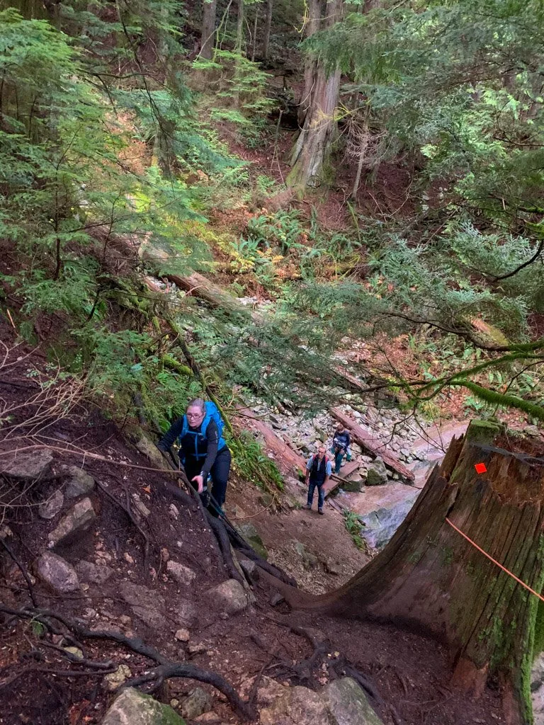
The trail crosses a broad bridge almost immediately after the junction. A few hundred meters further you’ll reach the first of several gullies. The trail to the Big Cedar and Kennedy Falls follows an old logging road. While the roadbed is intact in most places, all the bridges over the creeks are gone. That means that in several places you’ll have to scramble down steep banks into the stream bed, then out the other side. Follow the trail down to the creek, then up the opposite bank. Most of the year you’ll be able to hop across on rocks and logs, but in times of heavy rain or snowmelt, you might get wet.
On the other side of the gully watch carefully for the trail markers as they make a sharp left to stay on the old road. Don’t get sucked into following a faint trail that parallels the creek! Continue on the main trail through the forest. There are several wet and muddy sections as well as lots of rocks. In many places, you can clearly see signs of the old roadbed with logs laid cross-wise across the trail forming an old corduroy road.
Be sure to keep an eye out for trail markers as you cross several more creek gullies, one of which has a few ropes to assist as you scramble down over tree roots. About 1.5km from the gravel road, watch for a tree with enormous burl on your left. This burl is about the size of a smart car! From the burl, the trail loses a bit of elevation as it heads downhill for the next 1km or so to the Big Cedar.

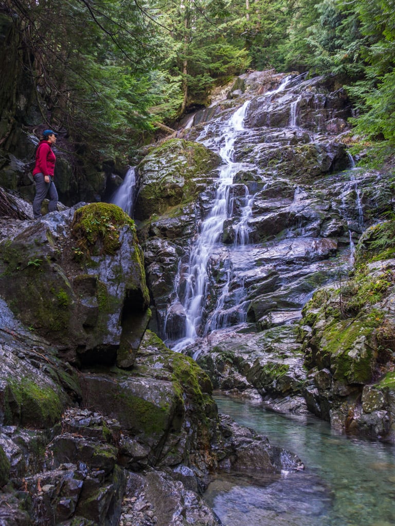
You’ll know when you arrive at the Big Cedar as it is much larger than any other tree you have passed so far. Experts estimate that it is over 600 years old. Its trunk forks into several smaller stalks not far above the ground. This deformity likely made it undesirable for lumber, which is why it was spared from the chainsaw and still stands today.


To continue on to Kennedy Falls, find the trail behind and to the left of the Big Cedar. The falls are another 1.5km from here. The trail climbs on a steep narrow path for a few minutes before rejoining the old logging road. Follow the old logging road as it gains a little bit of elevation and weaves around rocks and roots. The road eventually starts to curve to the left as it heads up the Kennedy Creek valley.
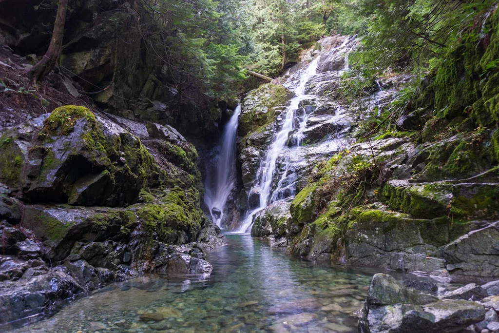
Stay on the trail as it traverses above a landslide, then starts to descend towards the creek. As the trail gets close to the creek is deteriorates into several social trails going in all different directions. Some of the trails are very steep, slippery and rocky, so watch your step. Once you reach the creek, walk upstream a few meters for the best view of the falls. It’s very chilly and dark in here since it gets very little sunlight and there is a lot of spray from the falls. Definitely pack a rain jacket, even if it’s a beautiful day. Once you’ve enjoyed the falls, retrace your steps back to your car.

Big Cedar and Kennedy Falls Loop Route Directions
If you are feeling adventurous, and conditions are right, it is possible to make this trip into a loop. It adds a little bit of distance and elevation gain to your trip, but the trail is much more groomed so it’s actually a little bit faster to make a loop. It’s important to note that the only way to make this loop is to ford Lynn Creek. This is dangerous at some times of year since the creek is very cold and can run fast and deep. It’s only safe to make this crossing in the summer or in times of low creek flow. DO NOT cross when the creek is high such as after heavy rainfall or snowmelt. (Note: If you plan to do the loop route, parking at the Lynn Headwaters lot is the best choice.)
To make this route into a loop, hike the trail as described above to Kennedy Falls. From Kennedy Falls, retrace your steps back to the Big Cedar. At the Big Cedar look for the descending steeply towards Lynn Creek. Follow the trail down the hill, watching for flagging to stay on track. At the bottom of the trail, you’ll reach the rocky creek bed.
Look across the creek and slightly downstream. There should be flagging indicating where the trail continues on the other side. The creek bed is rocky and slippery. Bring neoprene water shoes or sandals or just keep your hiking boots on. Don’t cross in bare feet as it’s too slippery and your feet will get banged up. Hiking poles or sticks are essential for balance.

Cross the creek in the widest and slowest area of the flow. It shouldn’t be much deeper than your knees. If it is, turn around and retrace your steps – it’s dangerous to continue. Cross facing upstream so that the current doesn’t buckle your knees. Use your hiking poles and move in a sideways shuffling motion so that you always have three points of contact with the riverbed. And if you don’t feel comfortable with the conditions or your abilities, turn around and go back the way you came. Be safe about it.
On the other side pick up a faint trail marked with flagging tape. After a minute you will emerge on the main Cedar Mills/Lynn Loop trail. Follow the trail downstream for about 3km of fast walking on a groomed gravel trail. The trail crosses a bridge over Lynn Creek then ends at a parking lot.
From the parking lot follow the road a few hundred meters and watch for the Baden Powell trail leaving the road on the righthand side. Take the Baden Powell trail up the hill via several staircases. (Or if you parked at the Lynn Headwaters lot, continue down the road from the Baden Powell turn off to your car.) Stay on the Baden Powell for about 1km until it intersects Mountain Highway. Turn right and follow Mountain Highway for a few hundred meters back to the trailhead.
The Big Cedar and Kennedy Falls trail is a Vancouver-area hike that I definitely recommend. It’s surprisingly rugged and remote for something you can reach so easily from the city. And the Big Cedar is really spectacular. It’s really cool to stand next to a tree that has been around for hundreds of years!
Have you done this hike yet? What was your favourite part? Tell me in the comments.
Looking for more Vancouver-Area Hikes?
- The Best Vancouver Hiking Books
- Alternatives to the Grouse Grind: Steep Workout Hikes Near Vancouver
- 35 Vancouver Hikes You Can Get to on Transit
- Waterfalls Near Vancouver You Can Hike To
- Most Instagrammed Hikes in Vancouver (Updated for 2019)
- The 10 Best Hikes in Vancouver: A Local’s Guide
- 15 Unusual Hikes Near Vancouver
- 6 Easy Hikes in Vancouver for Beginners and Tourists


- Best Sun Hoodies for Hiking - June 3, 2026
- Lower Stein Valley Trail Hiking and Backpacking Guide - May 27, 2026
- The Best Things to Do in Vernon, BC - May 21, 2026
Jill
Monday 28th of January 2019
I hike to the big cedar tree nearly every year in late summer when Lynn Creek is almost dry. Best time for a safe crossing! If hiking in the reverse loop, turn off at bridge 52 on Headwaters Trail, a few hundred metered past the Cedar Mills site.
Taryn Eyton
Monday 28th of January 2019
Yes, late summer is a great time to do the loop with the low water levels. It can be a bit tricky to find the connector from the Lynn Headwaters side, but if you hunt around for it, it's there. I like hike to the tree first and then cross the creek at the end so I have the easy stroll out on the Headwaters trail to finish, rather than the tougher trail on the other side.
ricky
Friday 12th of January 2018
I'm going tomorrow cant find a good map that's free any ideas.
Taryn Eyton
Friday 12th of January 2018
Try www.openstreetmap.org - turn on the cycle layer to see the contour lines. Have a great hike.