

Banff National Park’s Egypt Lake area is gorgeous: a scattering of blue glacial lakes below rugged peaks. In between, you’ll find patches of meadows, majestic alpine larch trees, and well-maintained trails.
It’s a moderate hike to the Egypt Lake campground, which makes a great base camp for exploring. It’s a tough backcountry camp to reserve, so some people do it as an overnighter. But if you can book for more than one night, do it! You’ll get to do some great day hikes.
After having this hike on my list for the last few years, I finally made it happen. On my late-August trip, we spent three nights at the campground and visited all of the nearby lakes. We had some soggy and cloudy weather, but some patches of sun too.
In this post, I’ve got everything you need to plan a trip to this beautiful area. My guide to backpacking to Egypt Lake includes:
- Quick facts about Egypt Lake including distance, how long it takes, best time to go, and more
- A map and elevation profile, plus a downloadable gpx file
- How to get to the trailhead including info about parking and shuttle buses
- Egypt Lake reservations: key dates plus booking tips
- How much does it cost to go backpacking at Egypt Lake A detailed budget breakdown
- Detailed trail description, broken down into sections with distances, times, and camping info
- Alternative routes to get to Egypt Lake including trails from Sunshine Meadows and Highway 93
- Day hikes from Egypt Lake campground including Mummy Lake, Pharaoh Peak, and more
- Egypt Lake hiking tips: advice for bears, food storage, weather, and more
This is a sensitive wilderness area. Learn how to Leave No Trace to keep the wilderness wild. Make sure you are prepared by bringing the 10 Essentials. Get ready for adventure with this checklist of things to do before every hike.
Hey there: Some of the links in this post are affiliate links, which means I earn a small commission at no cost to you. Thanks for your support. -Taryn

Egypt Lake Quick Facts
Trail Overview: This area is one of the most popular spots in the backcountry of Banff National Park. It is a collection of small lakes set below dramatic peaks. The Egypt Lake campground makes a good base camp for exploring.
What’s With That Name? When A.O. Wheeler, the founder of the Alpine Club of Canada, hiked through here in 1913, the Pharaoh Peaks had already been named for their pyramid shape. Wheeler kept with the theme and gave other features in the area Egyptian names.
Route Options: The most direct route to Egypt Lake is via the Healy Creek Trail, described in this trail guide. But there are also other options, described in the alternative routes section.
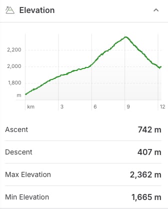
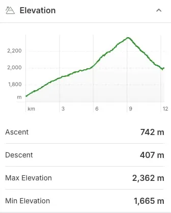
Distance: 24.6 km round-trip (plus side trips)
Elevation Gain: 1,135 m round-trip
Difficulty: Moderate
How Long to Spend: You can do it as an overnight trip, but I recommend 3 or 4 days so you have time for day hikes from your base camp at Egypt Lake.
Best Time to Go: Mid-July to mid-September when the trail is snow-free. For wildflowers aim for early August. For golden larches, go in mid- to late-September.
Reservations and Costs: You must make reservations and pay National Park entry fees, backcountry camping fees, and a reservation fee. More details are in the reservations and costs sections below.
What to Bring: This is a remote hiking trip with no services. Use my backpacking checklist to make sure you have everything you need.
Wildlife: The trail is in black and grizzly bear country. Carry bear spray, hike in a group, and make noise. Use campground cooking areas and store all your food and toiletries in the food lockers. Read my bear safety tips for backpackers for more info.
Dogs: Banff National Park discourages bringing dogs into the backcountry because they can trigger aggressive behaviour from wildlife. But dogs are allowed on leash.
Fires: Not allowed in the backcountry.
Indigenous Context: The Egypt Lake area is in the traditional territory of the Tsuut’ina, Blackfoot/Niitsítapi, Stoney Nakoda, Ktunaxa, Secwépemc, and Métis. Before Europeans arrived, the nearby Bow Valley was an important travel and trading corridor. The government forced Indigenous people to leave when Banff National Park was created in 1885 and prohibited them from accessing their traditional territory. Today, the park works with several Indigenous groups to facilitate park access for traditional, ceremonial, and cultural activities including harvesting.

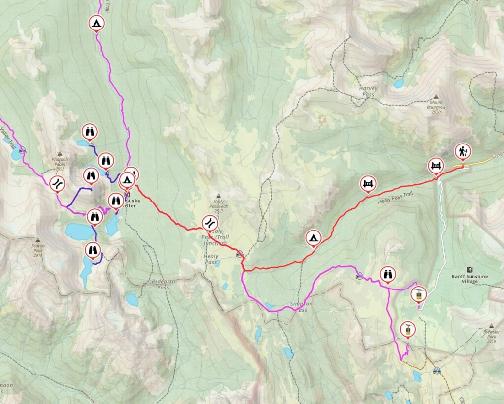
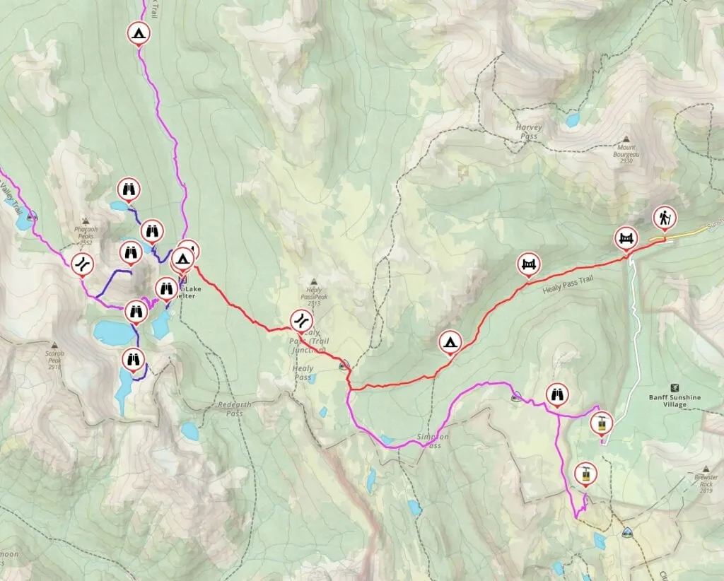
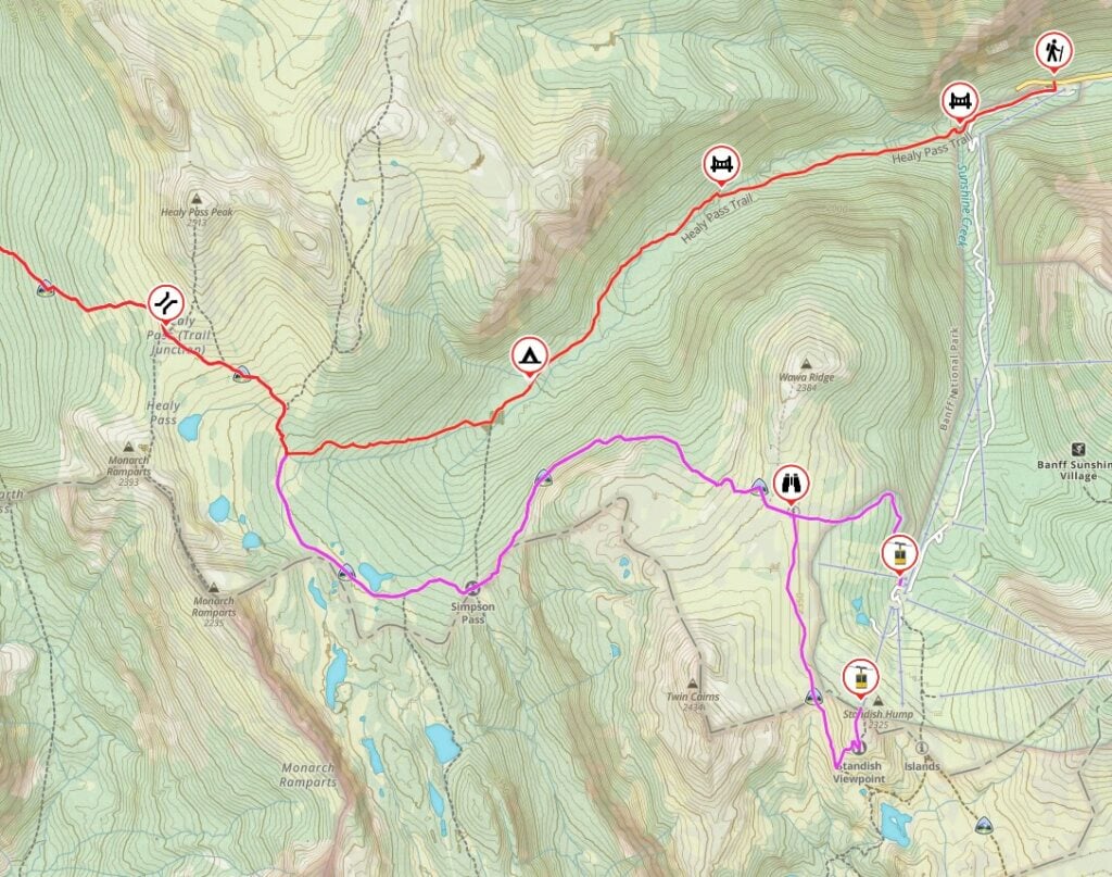
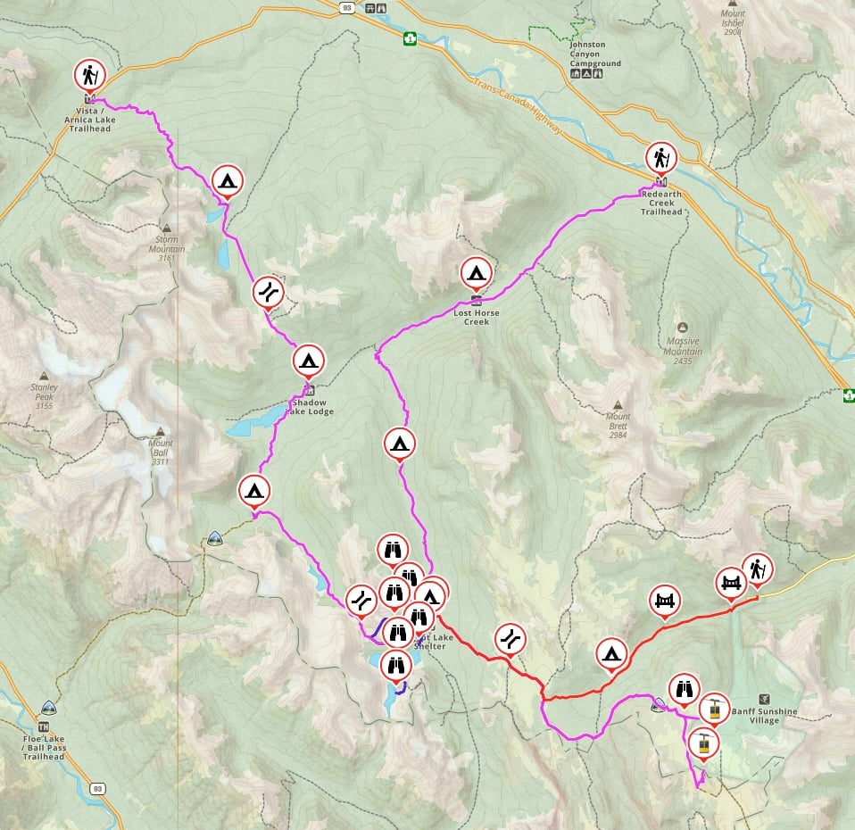
Egypt Lake Trail Map and Elevation Profile
The trails in the Egypt Lake area are well-marked and easy to navigate with signs at all junctions. If you want a paper map, the Banff and Mount Assiniboine Map from Gem Trek is the best one.
I used the Gaia GPS app on my hike. It was helpful to know where I was on the trail to figure out how much higher I had to climb and where the next campsite or landmark was. All Trails+ is also great.
I also made you a bunch of trail maps using Gaia GPS. Click through to zoom in and explore. You can also save it to your routes in Gaia GPS or export the gpx file. There are more maps in the route options section.
How to Get to the Healy Pass Trailhead
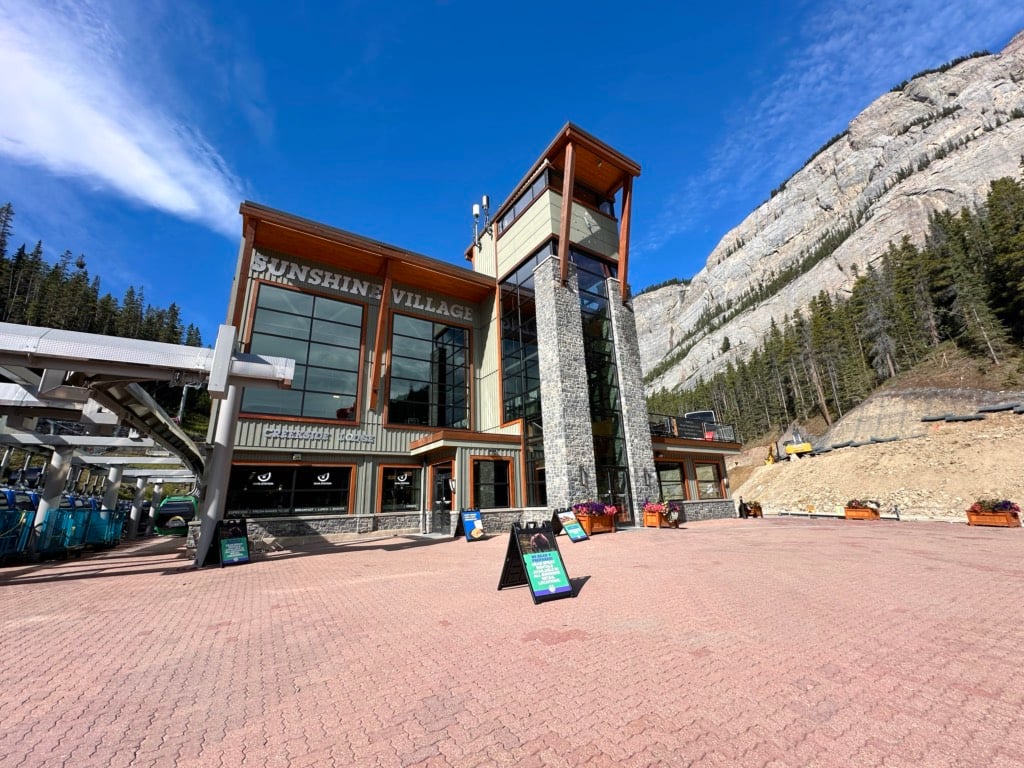
Egypt Lake is located in Banff National Park on the west side of Highway 1 between Banff and Lake Louise. Most people start the hike at the Healy Pass Trailhead at the Sunshine Village ski area parking lot. (I’ve got info on other trailheads in the alternative routes section below.)
The trailhead is a 20-minute drive from the town of Banff. To get there, go west on Highway 1 and then take the Sunshine Road exit. Follow that road until its end at the Sunshine Village base. Here are Google Maps driving directions.
You can park anywhere in the large parking lot, but you need to display a valid National Parks pass on your windshield.
If you don’t have a car, Sunshine Village offers a free shuttle from downtown Banff several times a day.
The Healy Pass trailhead is located on the west side of the main Sunshine Village gondola building. Walk around the back past the hotel guest check-in doors. There is a large info sign with a map and trail info. The trail starts by crossing the wide wooden bridge.

Reservations
Since Egypt Lake is one of the most popular backcountry campgrounds in Banff National Park, advance reservations are required.
Reservations for the entire summer season open in January or February each year. In 2026, reservations open on January 26, 2026, at 8 a.m. Mountain Time. You must book on the Parks Canada Reservations website.
See my tips for booking backcountry camping for pointers on how to navigate the site. Be ready to book as soon as reservations open as popular dates will sell out in minutes.
Your booking can include up to 10 people and up to 3 tent pads on the same reservation. Keep in mind that you are only allowed to have one tent per tent pad and four people per tent.
Step-By-Step Reservation Instructions
To make a reservation, select:
- “Backcountry” at the top (with the hiker icon), the
- “Backcountry Zone” button
- “Banff, Kootenay, and Yoho” from the Park drop-down.
- Access point “Sunshine Village” from the Access Point drop-down.
Have the following info ready to go when you make your reservation:
- preferred itinerary with campgrounds and dates as well as backups
- number of tent pads and people you are booking for
- credit card
If You Didn’t Get a Reservation
If you didn’t get a reservation at Egypt Lake Campground, keep checking back as people cancel and spots open up. A more efficient way is to sign up for a camping cancellation notification app like Campnab or Schnerp. Read my guide to camping cancellation apps to find out how they work and which one I recommend.
You can also camp at Healy Creek Campground 7.1 km from Egypt Lake Campground, or Pharaoh Creek Campground (4.8 km away). From those camps, you can day hike into the Egypt Lake area.

Fees
You must pay a few different fees to hike to Egypt Lake. The cost breakdown is as follows:
- Backcountry camping reservation fee: $11.50 per booking (for up to 10 people and up to 3 tent pads)
- Backcountry camping fee: $13.50/person/night
- Yoho/Banff/Kootenay National Parks entry fee: $11/person/day (or $22 per car/day with up to 7 people)
Most people spend three days/two nights at Egypt Lake. In that case, a solo hiker would pay $71.50. Per-person costs decrease if you hike in a group since you can share the expense of reservation and national park entry fees.
Egypt Lake via Healy Pass Trail Description
The most direct way to backpack to Egypt Lake is to to an out-and-back trip via the Healy Pass Trail. That’s what I did and what is described below. For other options, see the alternative routes section below. Below is a section-by-section breakdown of the Healy Pass Trail.
Healy Pass Trailhead to Healy Creek Camp
Distance: 5.3 km
Time: 1.25 to 2 hours
Elevation Gain: 335 m
Elevation Loss: 30 m
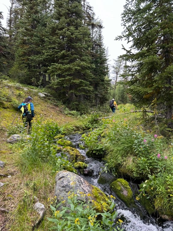
The first section of the trail from the parking area to Healy Creek Camp climbs gradually in the valley. The ascent is steady, but in most places barely perceptible.
From the trailhead, cross the bridge over the creek and follow the wide road-like trail. The Sunshine Village access road is up the steep bank to your left and you might occasionally see ski hill maintenance vehicles on the road.
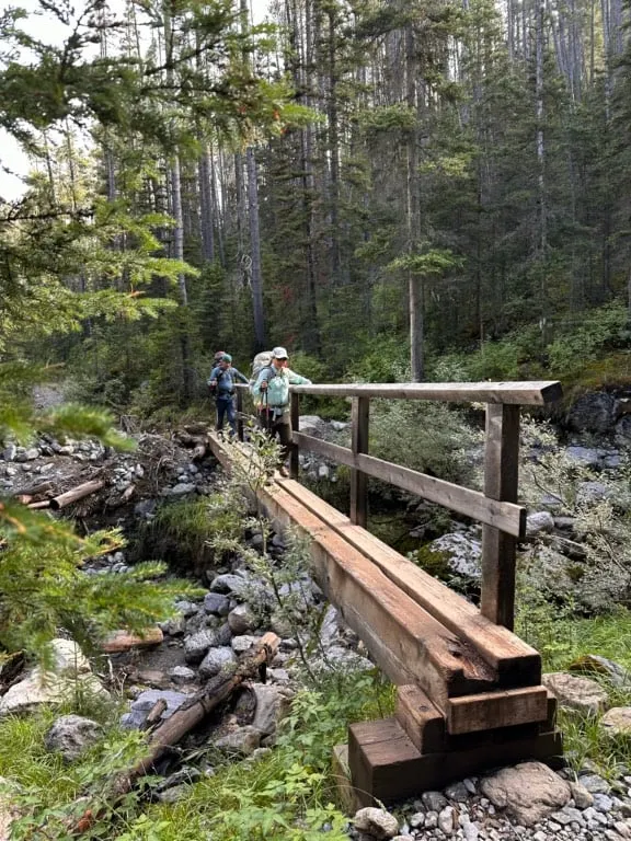
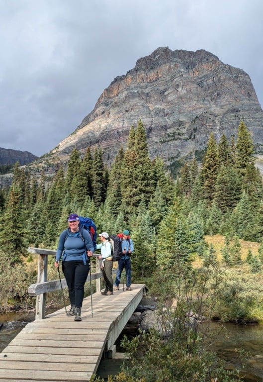
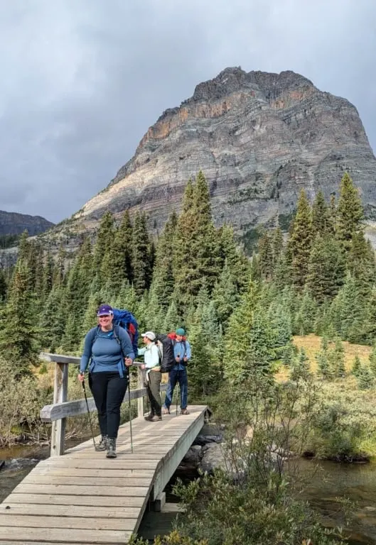
About 0.9 km from the start the trail dips down into a ravine and crosses Sunshine Creek on a long, narrow bridge.

On the other side, the path begins to look less like a road and more like a wide trail.A brief climb at the 1.5 km mark kicks the grade up for a few minutes, but the trail ascends more gently through the forest.
Reach the bridge over Healy Creek at the 3 km mark. There is a good spot for a break if you need one.

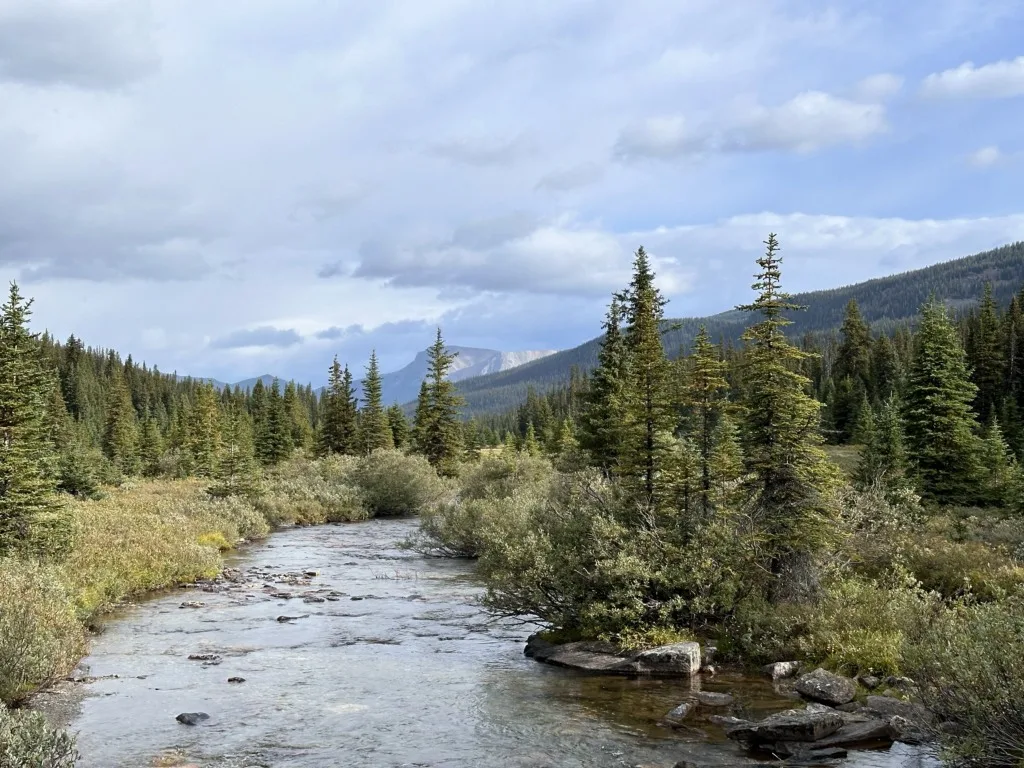
From the bridge, the trail meanders through the flattish valley bottom. The trail is mostly in the forest, but you pass through several avalanche paths. Healy Creek is off to your left. You can sometimes hear but it remains out of sight in the bushes.

Healy Creek Camp
Reach Healy Creek Camp at 5.3 km. It is set in the valley bottom near the junction of Healy Creek and an unnamed creek. The campsite is in a somewhat open forest. It’s a good spot to camp if you need to split up the trek over two days or if you can’t get a reservation for Egypt Lake Camp. Otherwise, it’s pretty meh.

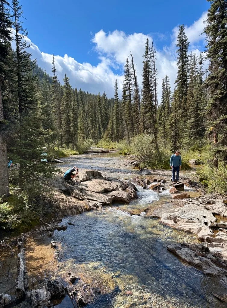
The campground has five dirt tent platforms and a newish outhouse. There is a cooking area on a spur trail to the east. It has one big picnic table and food lockers. Get water from Healy Creek via one of the brushy side trails from the cooking area or camping area.
Healy Creek Camp to Healy Pass
Distance: 3.8 km
Time: 1.25 to 2 hours
Elevation Gain: 380 m
Elevation Loss: 3 m
From Healy Creek Camp to the pass the trail begins to climb more than the route to camp. However, the ascent is never very steep – it’s a steady plod uphill.
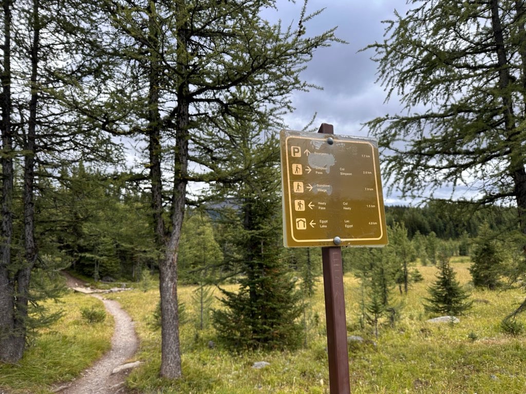
Follow the main trail out of the campground. Reach a junction with the trail to Simpson Pass 5.7 km from the trailhead. Go straight to stay on the main Healy Pass Trail.
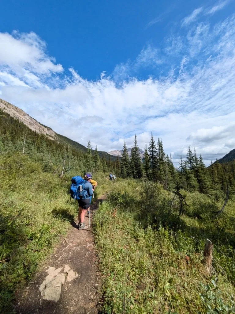
From here the climbing starts. Ascend steadily through the forest. As you begin to break out of the trees, reach another junction about 7.5 km from the start. Go right to stay on the Healy Pass Trail – the trail to the left is another route to Simpson Pass, Sunshine Village, and Eohippus Lake.

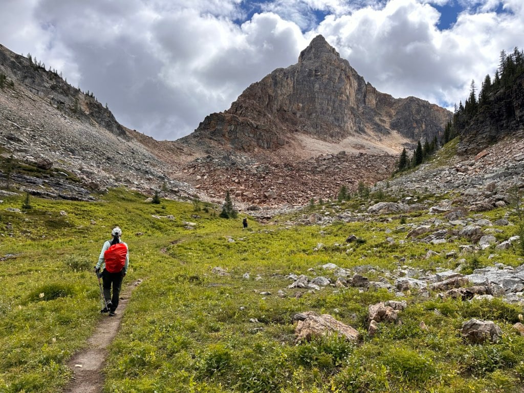
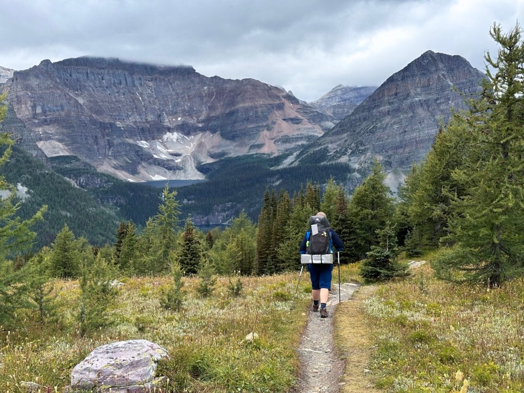
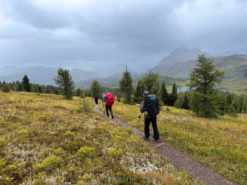
Past the junction, the scenery really improves. Make your way uphill through patches of meadow and clumps of larch trees. They hadn’t started to turn on my late August trip, but by early October they are spectacularly golden.
The wildflowers had finished by the time I got here in late August, but I’ve seen photos from other years, and it looks like you can get a great display through here from late July through mid-August.
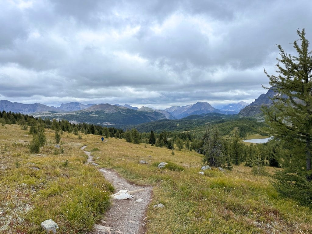

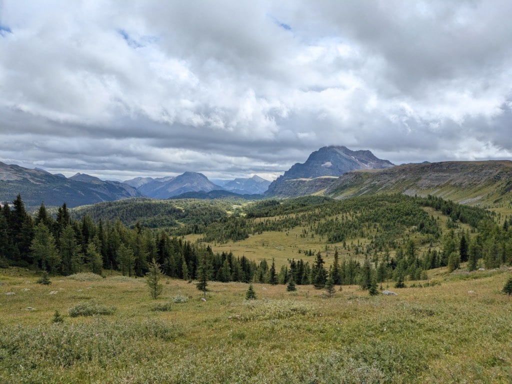
There are several unnamed tarns nestled in the meadows to your left (southwest) in front of the impressive peaks of the Monarch Ramparts with The Monarch behind them. If there aren’t too many clouds, you can also see the Matterhorn-like peak of Mount Assiniboine to the south.

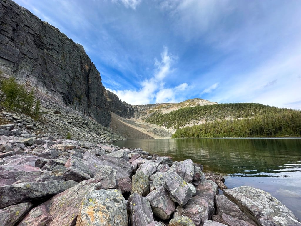
Reach the 2360 m high pass about 9 km from the start. It is marked by a sign. Looking west you can spot Egypt Lake and Scarab Lake below the imposing Pharaoh Peaks.

Healy Pass to Egypt Lake Camp
Distance: 3.3 km
Time: 1 to 1.5 hours
Elevation Gain: 15 m
Elevation Loss: 370 m
Your route to Egypt Lake Campground is all downhill. From the pass take the trail heading northwest – ignore the trail to the south that goes towards the Monarch Ramparts.
The first kilometre of the descent is in a sub-alpine meadow with clumps of larch trees. The descent gets a little steadier once you transition into the forest. It’s pretty much a straight shot downhill to the northwest. I don’t have any photos of this part because it was raining in this section on my hike in AND my hike out!
About 11.7 km from the trailhead the path starts to flatten out a bit as you get into the Pharaoh Creek valley. Pass a ranger hut at the 12 km mark, then cross the bridge over Pharaoh Creek at 12.1 km.

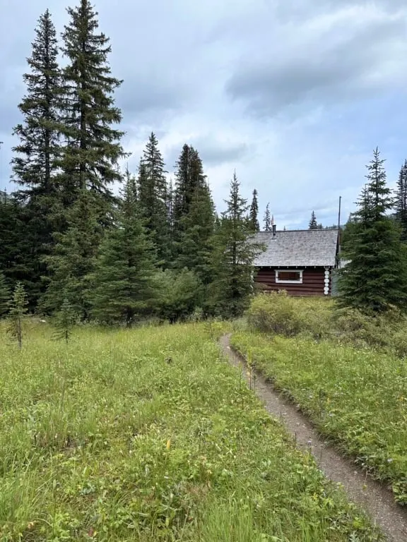
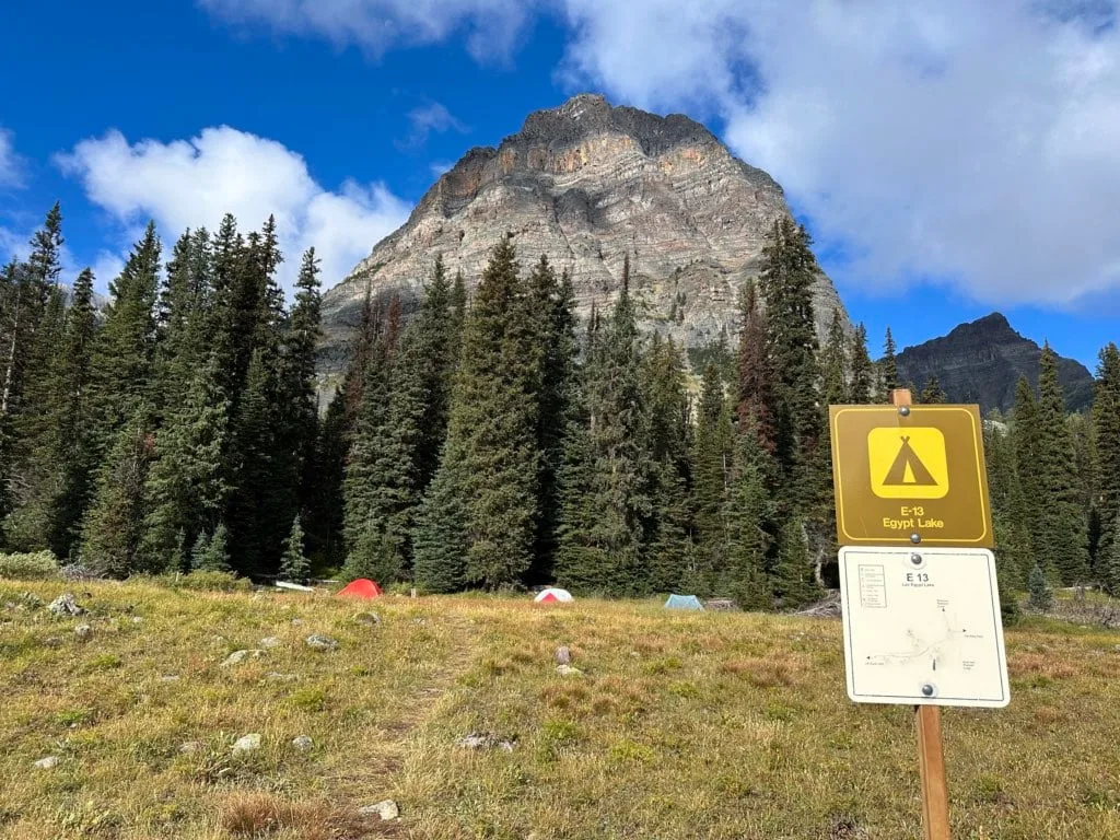
There are two trails from the bridge heading up the small rise. The first trail (northwest) goes to the Egypt Lake campground cooking area. The second trail (southwest) goes to the tenting area. Arrive at the campground 12.3 km from the trailhead.
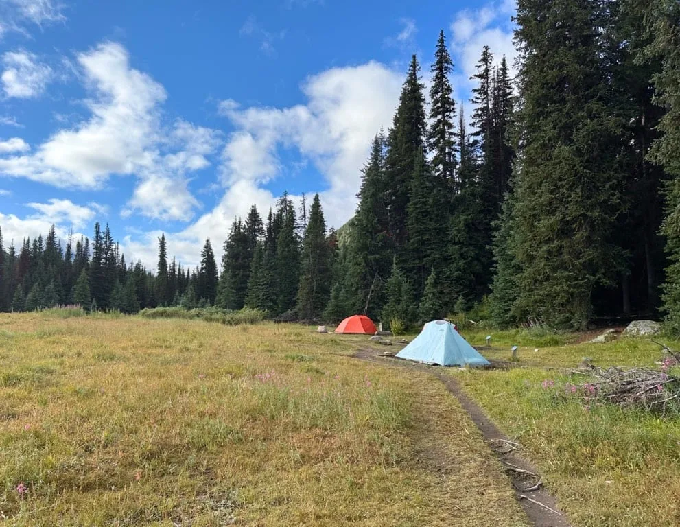
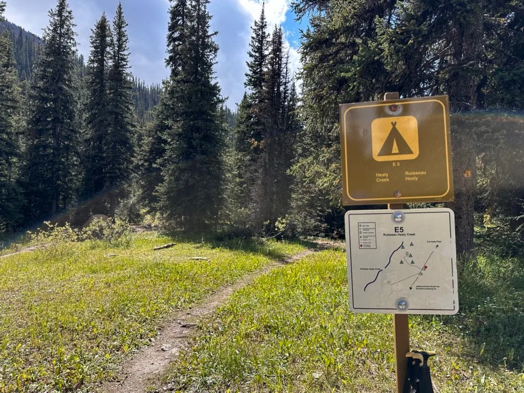
Egypt Lake Camp
Egypt Lake Camp is set in a patch of meadow above Pharaoh Creek. It’s important to note that it is NOT at Egypt Lake – the lake is about 0.75 km away.
It’s a good base camp for day hikes to the nearby lakes, passes, and peaks. (More on that in the day hikes section below.)
There are 15 dirt tent pads spread out along the main trail to Egypt Lake. Some of the tent pads have good views of Healy Pass. There are two elevated outhouses in the centre of the campground between clusters of tent pads.

Until 2023, the Egypt Lake Shelter used to be next to the outhouses. It was aging so they tore it down. Parks Canada has indicated that they intend to replace the shelter at some point, but I can’t find any info with a timeline. For now, there is a rectangular patch of grass where the shelter used to be.
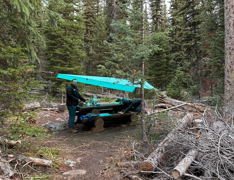
The cooking area is located along the Pharaoh Creek trail about 150 m north of the tent area. It has three large picnic tables and two clusters of food lockers. The picnic tables and food lockers are spread out along a maze of rooty trails. Head down to the bridge over Pharaoh Creek to collect water.


Alternative Routes to Egypt Lake
There are a few other routes to Egypt Lake that are popular enough to mention. I haven’t done these routes myself, but I did a lot of research leading up to my trip to figure out which way we wanted to hike in.
Here is a quick overview of the routes to Egypt Lake (one-way)
| Route | Distance | Time | Elevation Gain | Elevation Loss |
|---|---|---|---|---|
| Healy Pass | 12.3 km | 3.5-5.5 hours | 730 m | 400 m |
| Sunshine Village | 12.6 km | 3.5-5.5 hours | 510 m | 675 m |
| Gibbon Pass | 26.4 km | 2 days | 1,584 m | 1,270 m |
| Redearth | 19.3 km | 6-8 hours | 845 m | 265 m |
Sunshine Village/Simpson Pass Route
Distance: 12.6 km or 13.6 km
Time: 3.5 to 5.5 hours
Elevation Gain: 510 m or 370 m
Elevation Loss: 675 m or 740 m
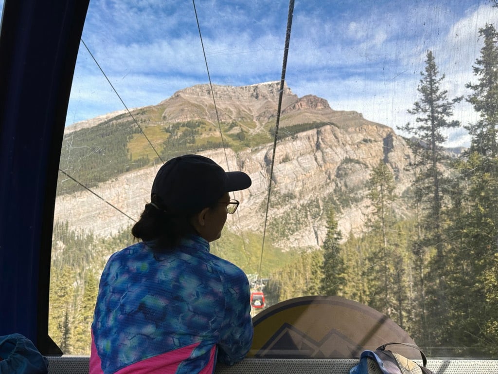
This route starts from the top of the Sunshine Village Gondola (which I have ridden – it’s gorgeous up there! Read my Sunshine Meadows hiking guide.) Since it starts high, there is a bit less elevation overall, but it’s a rolling route. This route is also more expensive since you have to pay for the gondola. There are no backcountry campgrounds along this route.

From the top of the gondola, you can take the Meadow Park Trail up to Monarch Viewpoint (2,350 m). From there, you descend to Simpson Pass, then climb up to Healy Pass where you follow the Healy Pass Trail directions above.
You can also add an extra kilometre and lots more scenery to this route by taking the Standish Chair from the top of the gondola up to the viewing deck. After enjoying the incredible views of Rock Isle Lake, take the Twin Cairns Trail to Monarch Viewpoint, where you meet up with the main Sunshine Village/Simpson Pass route.

Gibbon and Whistling Passes Route
Distance: 26.4 km
Time: 2 days
Elevation Gain: 1,585 m
Elevation Loss: 1,270 m

This route starts at the Arnica Lake Trailhead on Highway 93. It passes Arnica Lake, Twin Lakes, Gibbon Pass, Shadow Lake, and Whistling Passes before arriving at Egypt Lake. Most hikers using this route do it as a traverse, starting at Arnica Lake Trailhead and finishing at Healy Pass trailhead (or the reverse).
There are backcountry campgrounds at Twin Lakes, Shadow Lake, and Ball Pass Junction to split up the journey.
From everything I’ve read about this route, it is spectacular, with incredible scenery, especially at the passes.
This option requires arranging a car shuttle or an expensive taxi from Banff or Lake Louise. I thought about doing this route (and it does look incredible) but the logistics of trying to line up campsites and the car shuttle as part of an already-packed three-week roadtrip to the Rockies scared me off. Next time though!
Redearth and Pharaoh Creeks Route
Distance: 19.4 km
Time: 6 to 8 hours
Elevation Gain: 855 m
Elevation Loss: 265 m
See the map in the Gibbon and Whistling Pass section above to visualize this route or view it in Gaia GPS.
This route follows the Redearth Creek and Pharaoh Creek trails to Egypt Lake. It’s entirely in valley bottoms so it isn’t as scenic or popular. However, it is usually snow-free earlier in the year.
Along the way, you will pass by Lost Horse Creek and Pharaoh Creek Campgrounds. You can also make a detour off of this route to stay at Shadow Lake Camp.


Day Hikes from Egypt Lake Camp
Egypt Lake Campground has a great base camp for day hiking. There are lots of options in the area. I’ve got lots of options below. All stats assume you start at Egypt Lake campground.
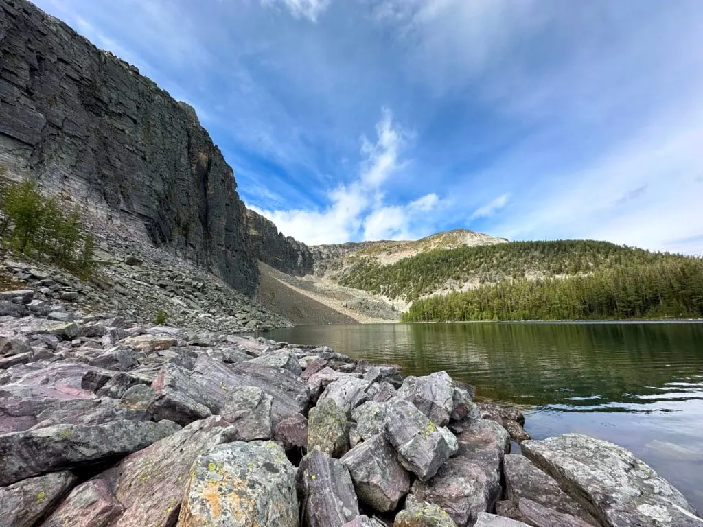
Egypt Lake
Distance: 1.4 km round-trip
Time: 20 minutes
Elevation Gain: 20 m

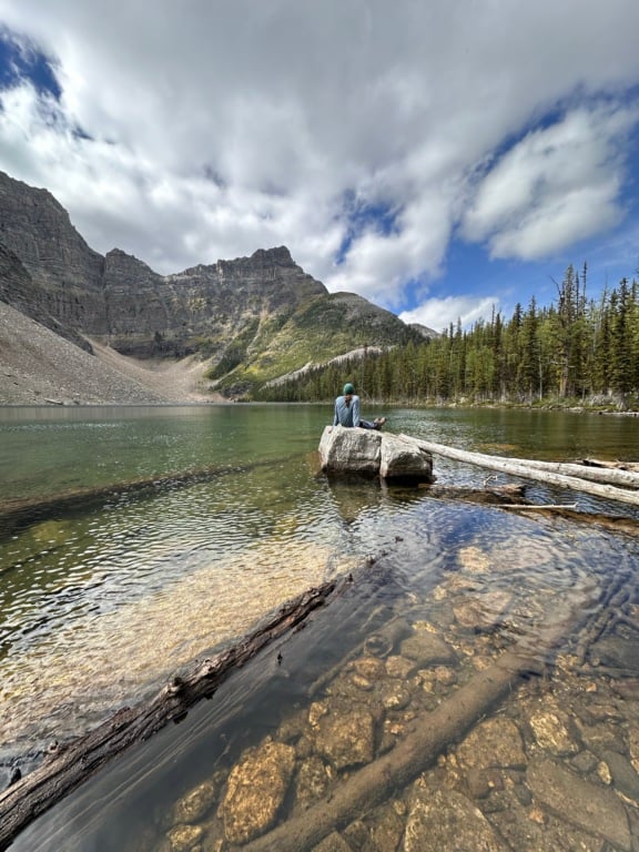
Egypt Lake is a quick hike from the campground. It’s short enough that you can do it the same day you arrive. From the middle of the campground near the outhouse, follow the trail southwest through the tenting area.
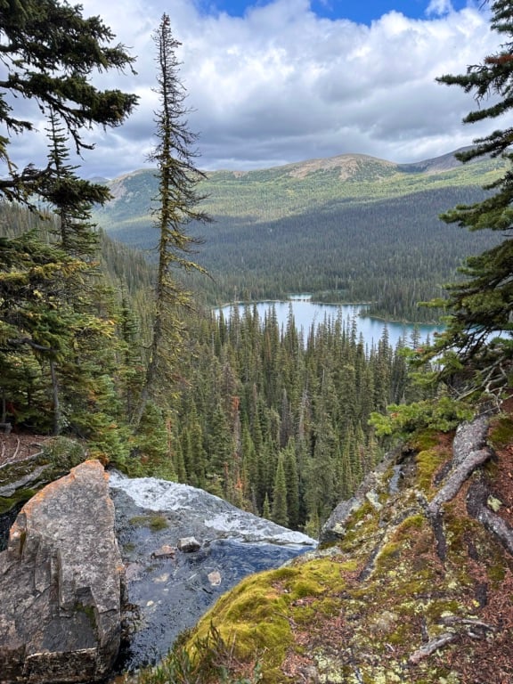
In a clearing, turn left onto the marked Egypt Lake trail. It’s another few minutes winding through the forest and past some seasonal ponds to the lakeshore. The lake is gorgeous and has a great waterfall coming in from Scarab Lake.


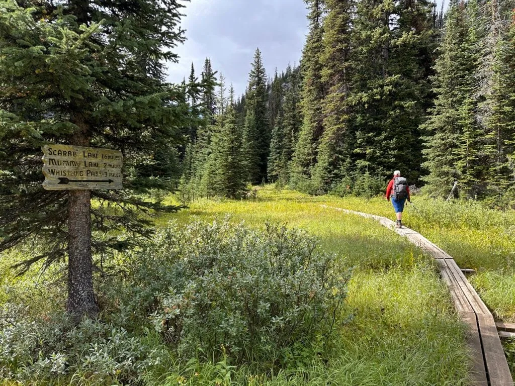
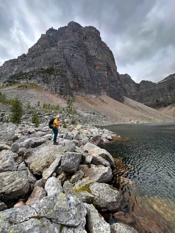
Scarab and Mummy Lakes
Distance: 7.1 km round-trip
Time: 3 to 4 hours
Elevation Gain: 500 m
See the map in the Egypt Lake section above to visualize this trail or view it in Gaia GPS.
Follow the trail from the campground to the Egypt Lake junction, but continue straight.
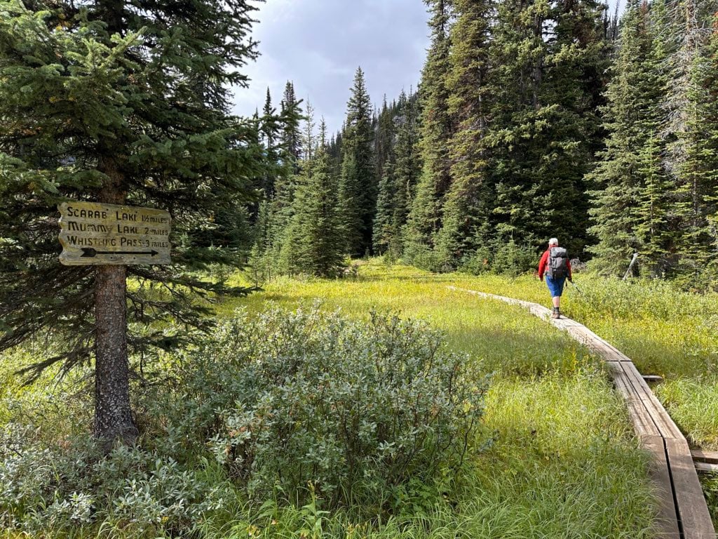
The trail climbs steeply on switchbacks beside scree slopes and through the forest. (Watch for adorable pikas in the rocks.) About 1.4 km from camp there is a good viewpoint on an open rock bluff.
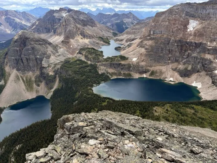
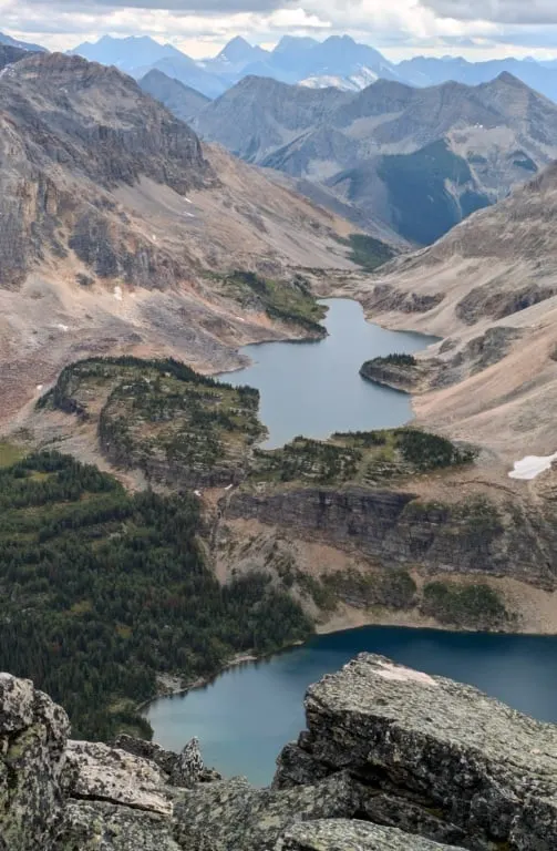
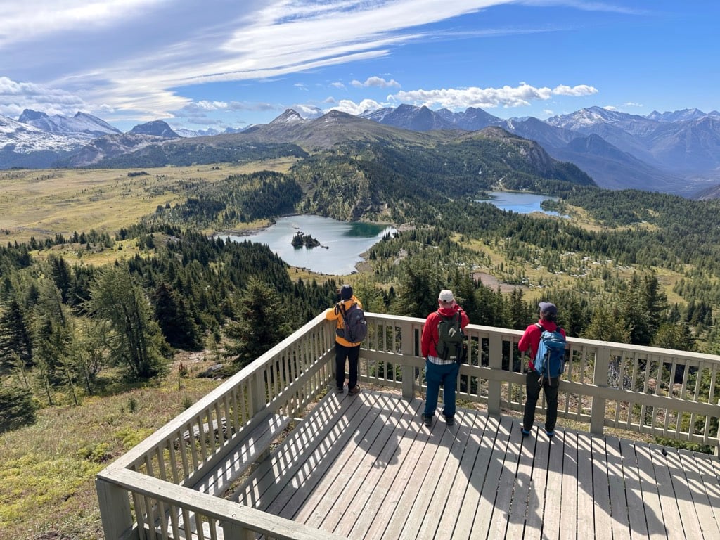
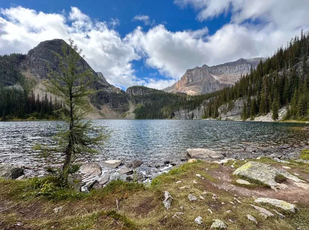
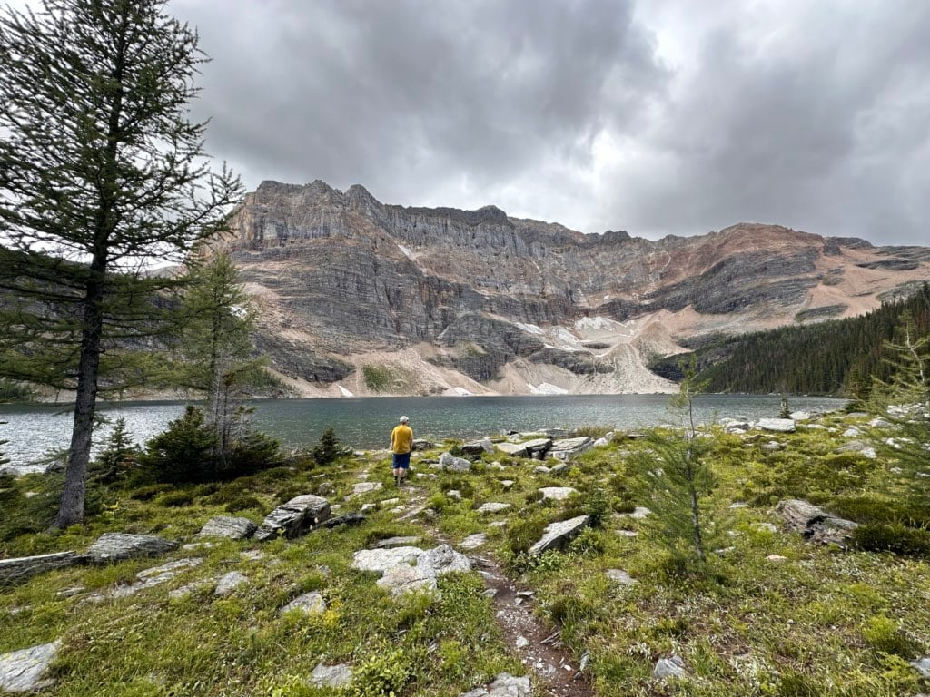
Reach a junction 1.8 km from camp and go left, descending through patches of meadow to the shore of Scarab Lake. (The scarab beetle was an important symbol in ancient Egypt.) The lake has great views of Scarab Peak.

Continue along the lakeshore and cross the outlet stream. Detour a few meters east to see the waterfall feeding Egypt Lake.

Follow the trail uphill through larch forest, then beside a scree slope. Descend into a pocket of meadow.

From there, follow cairns southwest uphill through rocks and rubble to the shore of Mummy Lake. You may have to do a bit of route-finding here to stay on track. Arrive at the lakeshore and enjoy the incredible turquoise lake and isolated moonscape setting.

Pharaoh Peaks Scramble
Distance: 7.7 km round-trip
Time: 4 to 6 hours
Elevation Gain: 795 m
See the map in the Egypt Lake section above to visualize this trail or view it in Gaia GPS.
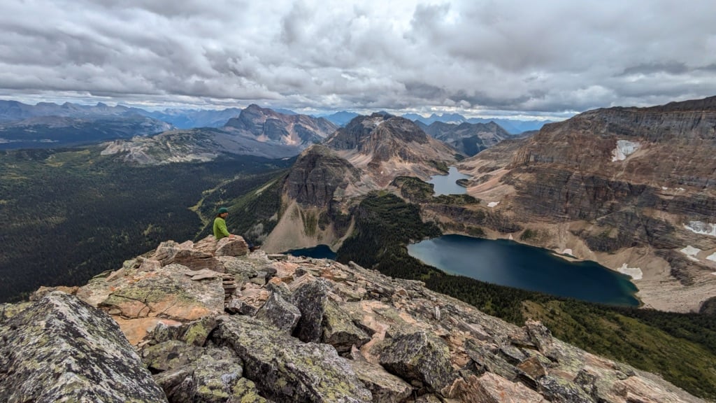
If you’ve seen incredible photos of the Egypt Lake area, they were likely taken from the Pharaoh Peak scramble. I was recovering from an ankle sprain on my trip, so I didn’t do the scramble, but two of my friends did. If you’re up for this scramble, I highly recommend it. It has by far the best views in the whole area.
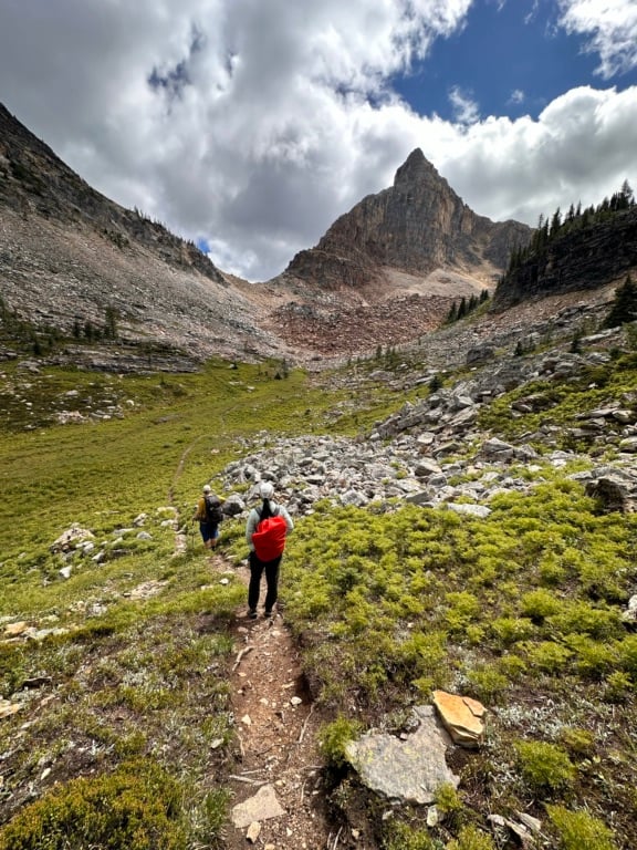
To do this scramble, follow the trail from the campground to the Scarab Lake junction. Continue along the trail for another kilometre as it side hills through forest and patches of meadow. Just before Whistling Pass, turn right and leave the trail.

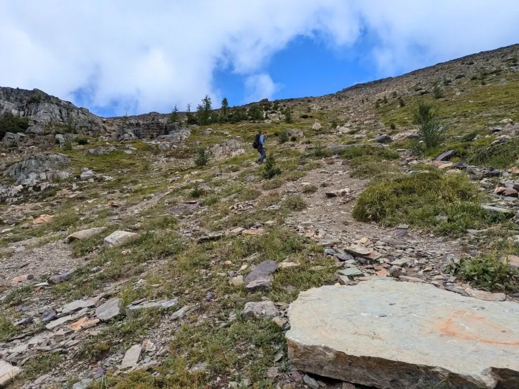
From here you will be on an unmarked and unmaintained route. It is steep, but there is no exposure. Follow an obvious gully up to a saddle. It is loose, but not technical. At the top of the gully, reach a saddle. Turn right and make your way through talus and boulders to the summit. The view is insane!

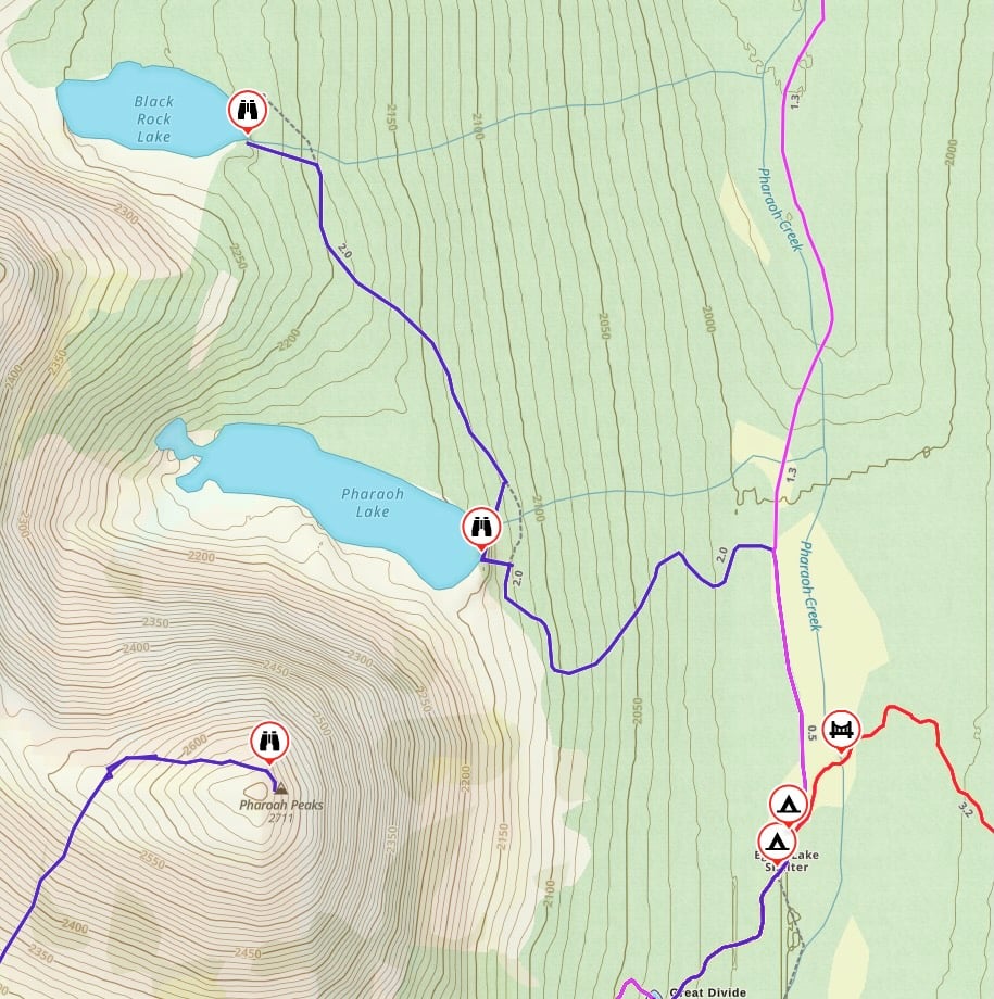
Pharaoh and Black Rock Lakes
Distance: 5 km round-trip
Time: 1.5 to 2 hours
Elevation Gain: 245 m

The trail to these two lakes seemed to be less trodden than the other lakes in the area. We had the whole area to ourselves!
To get there, head north from the campground cooking area on the Pharaoh Creek Trail. A few minutes after leaving the cooking area, turn left onto the Pharaoh Lake Trail. Follow it steeply uphill through the forest and then alongside a scree slope.
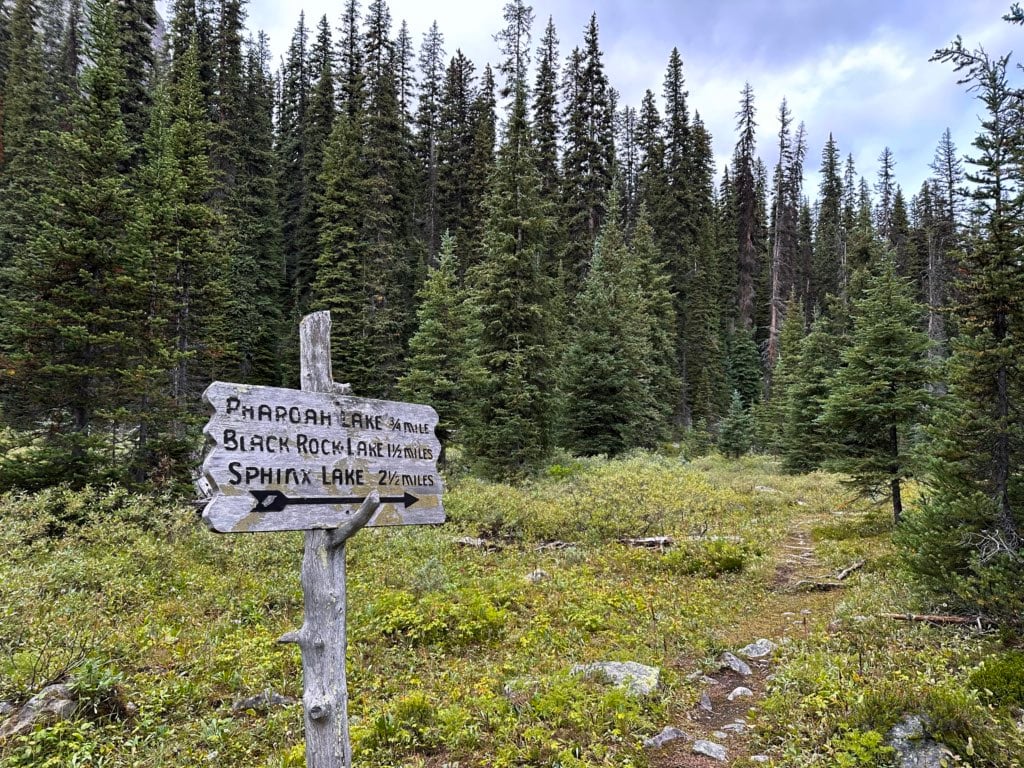
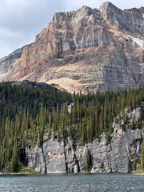
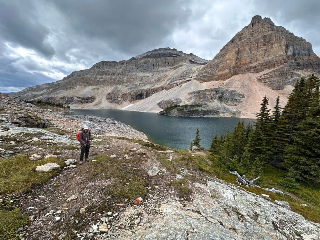
Arrive at the shore of Pharaoh Lake about 1.4 km from camp. The sheer face of Pharaoh Peak drops dramatically into the lake.
Continue north along the lakeshore and back into the forest to the northwest to get to Black Rock Lake. The last few minutes of the trail follow a pretty little stream with lots of wildflowers. The black rock face of the northern Pharaoh Peak gives the lake its name.

Egypt Lake Hiking Tips
Cooking Areas: The campground has a communal cooking area with three big picnic tables. It was nice to have a place to sit down each evening! But don’t hog the tables – they are for everyone to share. The cooking areas are separate from the tenting areas for bear safety. Please don’t eat or cook near your tent.
Food Storage: The campgrounds have metal food lockers for food storage. Each locker has a number which corresponds to the number posted at your tent pad. Use your numbered locker – it gets chaotic and confusing otherwise.
Mosquitos: Bugs can be bad in July and early August. Bring bug spray and a head net.
Bears: This is black and grizzly bear country. Bring bear spray, make noise while hiking, and store your food securely. See my bear safety tips for more info.
Check the weather before you go: The campground is at 2000 m and you have to crest a 2,260 m pass to get there. The entire area has fickle mountain weather. In July and August, the average high temperature is 21°C and the average low is 4°C. Sudden rain storms are common. Use an algorithmic spot forecast like Spotwx. (Read my guide to weather apps for hikers for more tips.)
Check trail conditions on the Banff National Park website. This is especially important in early summer or fall when the trail can be icy or snowy.
Check Sunshine Village opening hours if you plan to use the Sunshine gondola to get to the Simpson Pass route to Egypt Lake.
Off-trail travel is not allowed between Sunshine Meadows and Healy Pass on both the Simpson Pass and Healy Pass Trails. This rule is in place to protect grizzly bear habitat.
Final Thoughts
Egypt Lake has been on my list for a few years and I’m glad we finally made it. The lakes were all so gorgeous and despite this being one of Banff’s bigger backcountry campgrounds, the trail and camp never felt crowded.
While my visit was great, it wasn’t enough. I’d love to go back and do the full traverse from Highway 93, finishing at Egypt Lake. I’d also like to come back in the fall for larch season – from the photos I’ve seen, Healy Pass is incredible once the larches turn golden in the fall.
Is there anything else you need to know about backpacking at Egypt Lake? If I missed something, ask in the comments. I’d love to help.
READ NEXT:
- 11 Best Backpacking Trips in the Canadian Rockies
- Hiking at Sunshine Meadows in Banff – Is it Worth It?
- Mount Assiniboine Hiking Guide
- Skoki Loop Hiking and Backpacking Trail Guide
- Backpacking Checklist: Gear You Need To Go Backpacking
- Bear Safety for Hikers, Campers and Backpackers
- The Best Weather Apps for Hiking


- Grasslands National Park Travel Guide - February 4, 2026
- The Best (and Worst) Backpacking Meals Reviewed - December 16, 2025
- My Favourite Hiking Gear of 2025 - December 9, 2025