

We’ve all heard this advice: “Make sure you are prepared. Check trail conditions online before you go.” But how do you actually find trail conditions? How do you find out if the trail is muddy, snowy, unmaintained, full of bugs, or closed?
I wish I had one easy answer for you. Wouldn’t it be great to say, “Oh, you just check this magic website called…”. I’m sorry, it doesn’t exist. Instead, you have to check in a bunch of places.
I’ve got tips for where to find trail conditions for hikes all over Canada and the United States. I’ve also got some general tips on how to prepare for a hike.
In this post you’ll find:
- How to find trail conditions: eight places to check
- Why is checking trail conditions important? What will happen if you don’t?
- What should you do if you can’t find up-to-date trail conditions? Should you hike anyway?
This is a sensitive wilderness area. Learn how to Leave No Trace to keep the wilderness wild. Make sure you are prepared by bringing the 10 Essentials. Get ready for adventure with this checklist of things to do before every hike.
Hey there: Some of the links in this post are affiliate links, which means I earn a small commission at no cost to you. Thanks for your support. -Taryn

How to Find Trail Conditions
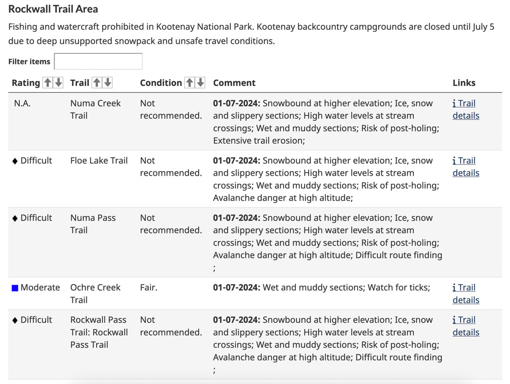
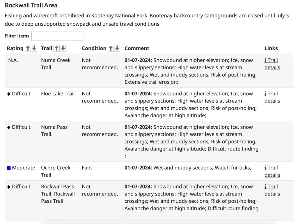
Check Park Websites
Many, national, state, provincial and regional park websites have a trail conditions section written by a park ranger. Some parks may update their conditions less frequently than others, but it’s often worth looking anyway.
Look up which park the trail you plan to hike is in, then head to the park website. Finding the trail conditions section can be tricky on some parks’ websites. Look for a pinned advisory at the top of the page or click through to the “hiking” or “planning your trip” sections.
If you can’t find the info you want on their website, some parks (especially National Parks) have visitor centers or ranger stations you can call or visit before your hike.
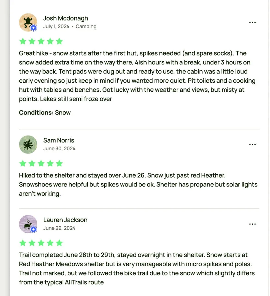
Read Trail Reviews on AllTrails
By far the most popular hiking app in North America is AllTrails. Lots of people use it to find nearby hikes, but you can also use it to leave reviews for hikes. If you scroll through the recent comments, you can often find valuable trail conditions info.
However, keep in mind that, unlike park ranger-generated trail conditions reports, regular people with a variety of hiking experience levels write AllTrails reviews. That means that you should take these reviews with a grain of salt. Some reviews might overstate the hazards while others might downplay them.

Check Instagram
You might be using Instagram to find hiking inspo. But I also find Instagram really helpful for checking trail conditions since it is so visual. Use the in-app search function to find the area you want to hike and be sure to check both the location tag and hashtag feeds. Choose “more recent” rather than “most popular”.
Be sure to check the date the photo was posted AND the caption to make sure you are looking at a current photo, not a throwback shot. And keep in mind that most people post photos of the beautiful parts of the hike, not the hard stuff or the ugly stuff, so you likely aren’t getting the full picture.
The Instagram community is quite friendly so if you see a recent photo from an area you want to hike, go ahead and ask for more info about trail conditions in a comment. You might get the best info that way, and make a new online friend.
Scroll Through Facebook Groups and Subreddits
These days there is a regional Facebook group or Subreddit for hiking pretty much everywhere. To find a local one in your area, search “[name of your city/region] hiking” on Facebook or Reddit. (On Facebook you will also want to filter by groups.)
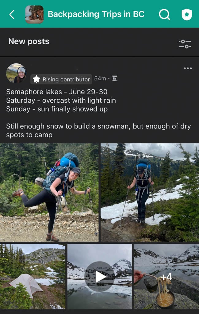
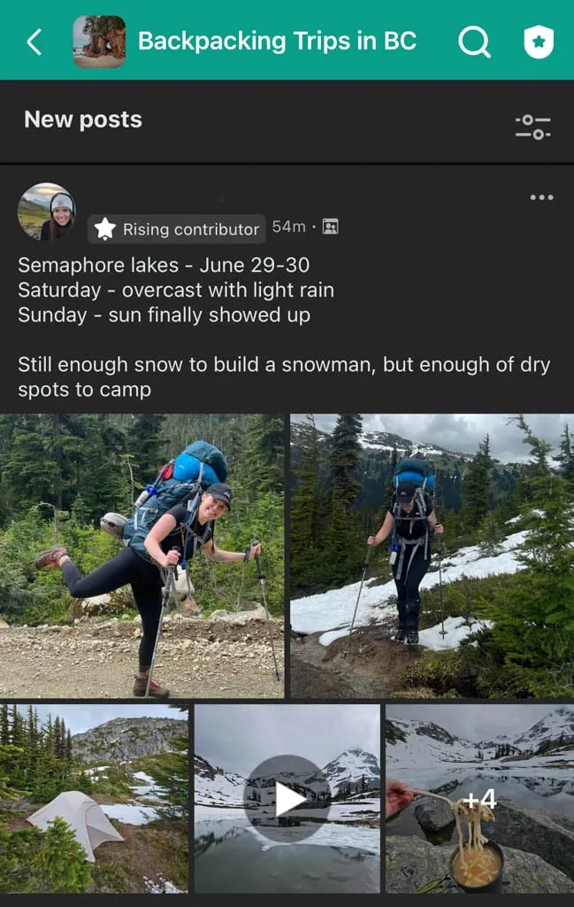
Backcountry skiing or mountaineering groups can be helpful too since they often share the same approach trails as hikers. Some bucket list trails or national parks also have their own Facebook groups or sub-Reddits.
Before you add a post to the group asking for trail conditions, scroll through the most recent posts or use the search bar to see if someone else has already added info about the trail you are looking for.
Just like with Instagram or All Trails, keep in mind that the responses you get about trail conditions will come from people with various levels of experience and risk tolerance.
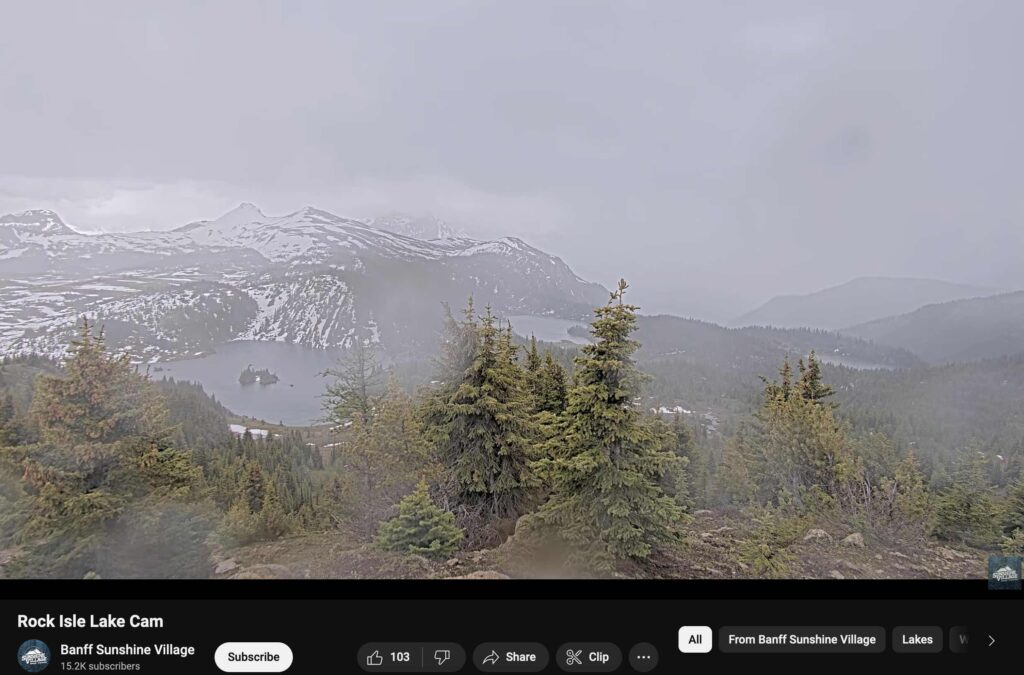
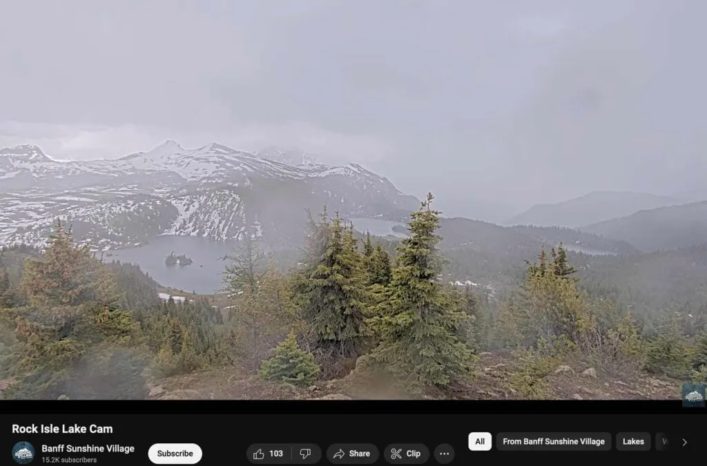
Check Web Cams
Webcams can be really helpful to judge current snow conditions, especially in the spring and fall when snow cover can be hard to predict. Very few trails have live webcams, but you can often find webcams close to trails. The most useful webcams are ones at roughly the same elevation as the trail you plan to hike.
Ski area and highway webcams can be a great resource. Google ski areas near where you want to hike or visit state or provincial highways websites to find them.
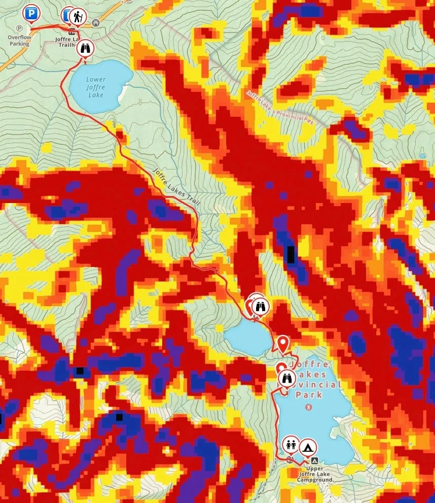
Look at Recent Aerial Photos on Copernicus Browser
One of my favourite ways to check snow cover is to check Copernicus Browser. It provides up-to-date satellite images from around the world. (FYI: This site used to be known as Sentinel Hub Playground.)
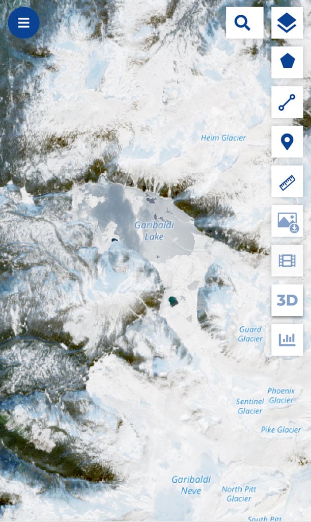
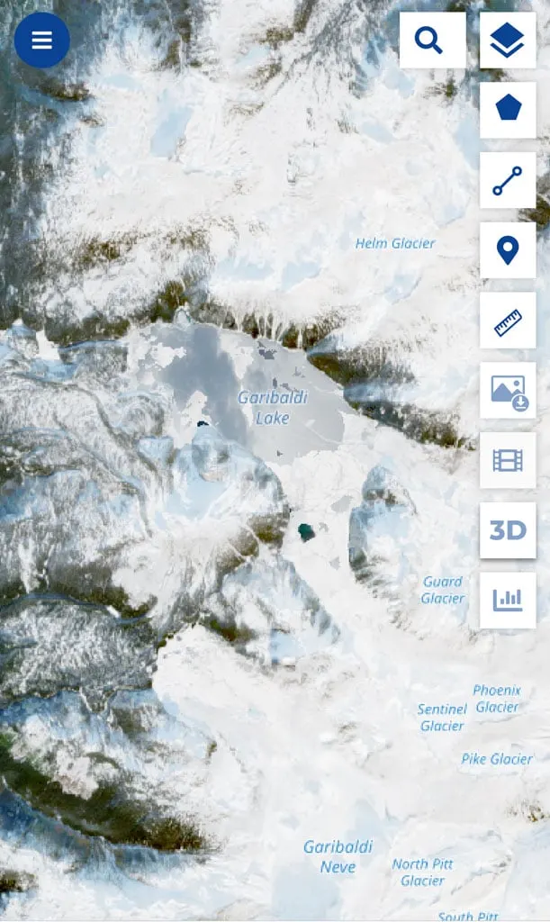
But keep in mind that when the snow is melting, the forests can often look green in the photos but there is snow hiding under the branches! Be sure to look for clearings, roads, and lakes to see if there is snow there.
The interface for Copernicus Browser is not intuitive. But if all you want to do is navigate to a named place and look at a recent satellite photo, it’s pretty easy to use.
You can scroll around to find the location you want or use the search bar to find named locations. You can also use the calendar to see when the most recent satellite photo was taken. Or you can adjust the date to find satellite photos from dates in the past. The calendar also shows which dates have photos with clear skies and which ones are obscured by clouds.
Look Up Smoke and Fire Info on FireSmoke
Unfortunately, in many places, summer is forest fire season for hikers. Even if no fires are burning near your hiking destination, winds can push smoke for hundreds of kilometres, making for an unpleasant hike or dangerous air quality.

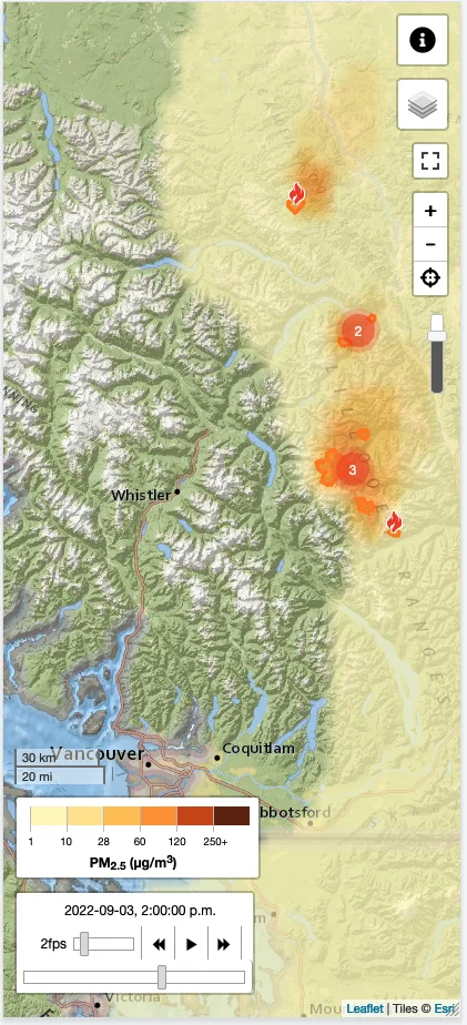
I like to check the smoke forecast map on FireSmoke before my trip so I know what to expect. It uses an easy-to-understand animation that overlays the boundaries of nearby fires on a map along with a projection of where the smoke will blow. Colours show you how “bad” the air quality will be. You can also toggle between an hourly forecast, daily average, and daily maximum.
I’ve got a whole guide to safe hiking in wildfire season with more tips.
Check the Avalanche Forecast
Snow + slopes = avalanches. Hikers and snowshoers need to know the avalanche forecast to stay safe. In the United States, use Avalanche.org. In Canada, check the forecast on Avalanche.ca.
Posted forecasts will give you an idea of the snow conditions as well as what types of terrain are the most susceptible to avalanches.

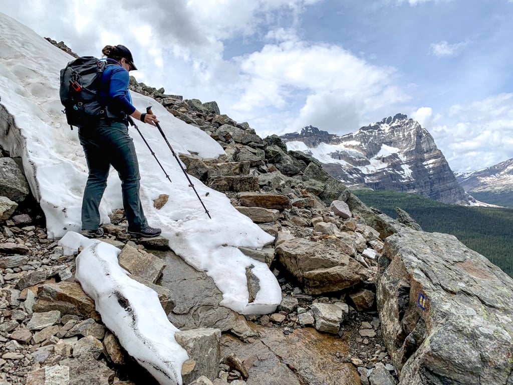
There are no avalanche forecasts in the spring and early summer, but there can still be lots of snow in the mountains. You need to know how to recognize and avoid avalanche terrain when you hike. That means avoiding travelling on or below steep, snow-covered slopes. I like to use the slope angle overlay on Gaia GPS to help identify slopes that could slide.
Why is Checking Trail Conditions Important?
There’s nothing worse than getting halfway up a mountain to be stopped by snow. Or getting eaten alive by bugs because you didn’t bring bug spray and a long-sleeved shirt.
If you research the trail conditions ahead of time you have a higher chance of having fun since you’ll be able to pick an appropriate destination for your abilities, the weather and the current trail conditions. You’ll also bring the right gear and give yourself enough time to complete your hike.
More importantly, you’ll have a much higher chance of staying safe and avoiding getting lost. The first principle of Leave No Trace is to plan ahead and prepare, and checking trail conditions is an important part of that. Search and Rescue gets called out nearly every weekend for someone who didn’t check trail conditions. Don’t let it be you.

What Should You Do if You Can’t Find Up-to-Date Trail Conditions?
If you can’t find up-to-date trail conditions you have two choices: 1) Pick a different hike, or 2) Go anyway but bring lots of extra gear. Consider bringing gear for safe snow travel, such as an ice axe, trekking poles, microspikes, or snowshoes. Bring extra clothing for cold and wet conditions. Pack extra food and water in case it takes longer than you think.
Once you are on the trail (or even on the access road to the trail), be prepared to turn around if you face conditions that you aren’t prepared for. Flooded trails, slippery snow, washed-out bridges, blowdown trees obscuring the path and undrivable access roads are all good reasons to consider turning around.
It’s also a good idea to have a backup hike in the same area so you can do another nearby hike if the one you picked doesn’t work out.

Final Thoughts
I’ve definitely had some mishaps when I failed to check trail conditions. I remember one early summer hike when I didn’t check trail conditions and ended up post-holing into knee-deep snow for hours…. while wearing shorts. My shins got so cut up and my feet were soaked. Lesson learned: check the trail conditions!
What’s your favourite place to find good info on trail conditions? Tell me in the comments.
READ NEXT:
- 16 Things to Do Before a Hike
- The 10 Essentials: Things You Should Bring on Every Hike
- How to Leave No Trace (And Why it’s Important!)
- The Best Weather Apps for Hiking
- Tips for Safe Hiking in Wildfire Season


- 10 Best Things to Do in Saskatchewan - March 22, 2026
- The Best Things to Do in Saskatoon - March 17, 2026
- Grasslands National Park Travel Guide - February 4, 2026
Scott M.
Tuesday 25th of July 2017
Wonderful, as always. I'd also note that road conditions may change, dramatically in certain circumstances (eg. flood or earthquake). If I'm heading deep up a Forest Service Road, even for a day hike, I make sure I have basic food for two or three days as your car *will* become after an earthquake and you will *not* be a priority for emergency services (they'll be focused on building collapses, etc).
Tanis
Friday 7th of July 2017
Taryn, thank you for the excellent article. Very concise and informative. I have used several of these before, but now I have a whole new list to check out. For trails south of the border I often use the Washington Trails Association website (wta.org) and find it very useful and have wished there was something similar here.
Taryn Eyton
Sunday 9th of July 2017
Thanks for the kind words Tanis. I also love WTA for Washington. I would love something similar for BC. I also love the trail maintenance work that WTA does - wouldn't it be nice to have something like that for BC too!