
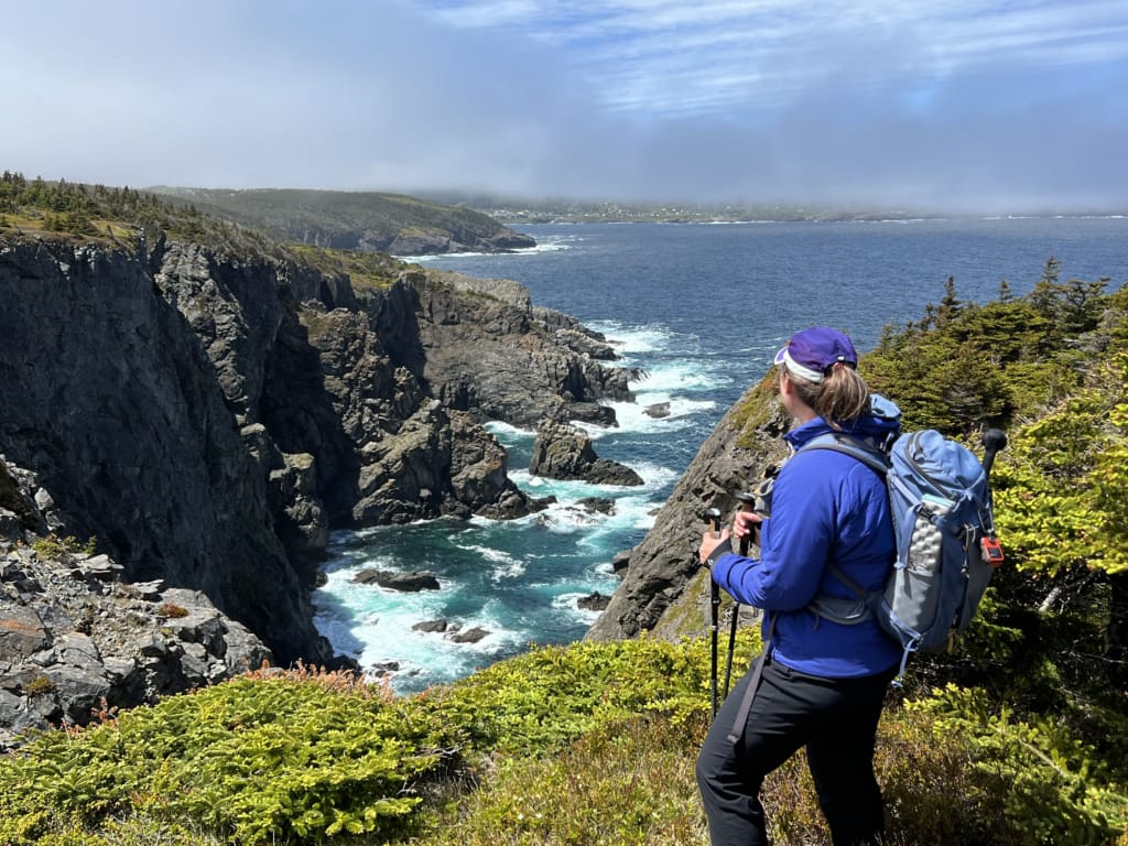
I first heard about the East Coast Trail over 20 years ago when I was living in Halifax. I can’t believe it took me so long to finally hike this spectacular network of coastal trails on Newfoundland’s Avalon Peninsula near St. John’s. While the entire trail is over 300 km long, it’s made up of 25 individual paths, so you don’t have to hike the entire trail.
I chose to hike six different paths over the course of a week. Each day on the trail, I soaked up the incredible scenery as I wandered along the tops of bluffs, through the forest, across open heath, and into coves. On a few days, I spotted whales offshore.
Instead of camping, I stayed in a B&Bs and hotels. You can arrange accommodation and trail shuttles yourself, but since I was short on time to plan, I used a tour company to handle the logistics. Each evening I headed back to a comfy bed, a hot shower, and a meal I didn’t have to cook over a camp stove that I enjoyed while chatting with locals. It was a great way to combine hiking and Newfoundland’s signature friendly hospitality.
Since I’m an experienced hiker, I did a ton of research on this trail, so I’ve put together a huge East Coast Trail guide for you. It includes:
- East Coast Trail at a glance: All the basics in one place.
- How the East Coast Trail works: An explanation of how this trail is different than most long-distance trails.
- Where is the East Coast Trail? My custom map shows all the paths, accommodations and other points of interest
- Choosing which East Coast Trail paths to hike: Tips for designing your own ECT itinerary.
- Camping vs B&Bs and hotels on the East Coast Trail: how each option works
- Getting to and from East Coast Trail trailheads: taxis, shuttles, hitchhiking, and more.
- My review of the six East Coast Trail paths I hiked, including highlights and lowlights.
- Navigation on the East Coast Trail: which apps and maps I recommend.
- What to pack for the East Coast Trail: my recommended packing list
- Safety, Regulations, and Trail Conditions on the East Coast Trail: Weather, dogs, hazards, fires, and more.
- When to hike the East Coast Trail: which months are best?
- East Coast Trail Resources: The other websites, maps, and guides I recommend.
This is a sensitive wilderness area. Learn how to Leave No Trace to keep the wilderness wild. Make sure you are prepared by bringing the 10 Essentials. Get ready for adventure with this checklist of things to do before every hike.
Hey there: Thanks so much to Newfoundland and Labrador Tourism, Legendary Coasts of Eastern Newfoundland, and Great Canadian Trails for hosting me on the East Coast Trail. All opinions in this post are my own. Some of the links in this post are affiliate links, which means I earn a small commission at no cost to you. Thanks for your support! – Taryn
Table of Contents
East Coast Trail at a Glance
Location: Avalon Peninsula, Newfoundland (near St. John’s)
Trail type: Point-to-point coastal hiking
Trail length: 270 km of trail and 66 km of community walks split into 25 individual sections (called paths)
Best for: Day hikes, multi-day backpacking trips, and thru-hikes
Accommodations: B&Bs, hotels, inns
Camping: Available but not necessary
Trail access: Drive, taxi, or accommodation shuttle
Scenery: Cliffs, beaches, coves, forest, historic communities, whales and other wildlife
Best time to go: June to September
Permits and fees: None required
My trip approach: 6 paths over 6 days. Accommodations and shuttles arranged by Great Canadian Trails.

How the East Coast Trail Works
The East Coast Trail isn’t structured like most long-distance trails or thru-hikes. Let me explain:
25 Individual Paths
The ECT is made of 25 individual paths. Each path is a point-to-point hike – there are no loops. In between each path are community walks that follow local roads and trails through towns and villages to connect with the next path. These are usually a few hundred meters, but in some places they can be as long as 5 to 8 kilometres.
The individual paths range in length from 3.8 km to 20.4 km. As well, the paths vary in difficulty from easy to strenuous. The terrain can also vary a lot; I encountered pretty much every type of trail surface, including roots, rocks, bog, boardwalk, stairs, mud, packed dirt, and gravel.
You Don’t Have to Hike the Entire Trail
Each year over 14,000 hikers spend time on the trail… but very few of them thru-hike. That’s because you don’t have to hike the entire trail: It is designed to be walked in sections.

Three Ways to Experience the Trail
There are three main ways to experience the East Coast Trail. I’ve got an overview of each below.
Thru-Hike Independently
Thru-hiking is the least common way to experience the East Coast Trail. Only about 100 people complete the whole trail each year. A few hundred more tackle multiple paths in a row as part of a multi-day backpacking trip.
Thru-hikers hike the entire East Coast Trail end-to-end consecutively. Most thru-hikers carry backpacking gear and camp along the trail, although most do spend some time in B&Bs or inns. Thru-hikers also arrange their own transportation to and from the trail’s start and end points.
Day Hike Independently
A more common way to hike the East Coast Trail is to do a series of independent day hikes. For this option, you choose a few paths, then book a B&B or hotel nearby. Each day you rely on a rental car, bus, walking or taxis to get you to and from the trailheads. (More on transportation options in the sections below.)
This option works best if you book accommodations that are close to the trailheads for a few different paths. I’ve got suggestions in the Choosing a Path section below.
Supported Self-Guided Trip
If you don’t want to deal with the logistics of the trip yourself, you can book a supported self-guided trip. Since I had limited time to plan my East Coast Trail hike (I added it on to a longer Newfoundland trip at the last minute), I chose to take a trip organized by Great Canadian Trails.
They arranged my accommodations, trailhead shuttles each day, luggage transfer, most meals, and a navigation app. I had a few different itinerary options to choose from, so I did get to pick which paths I hiked.
While Great Canadian Trails is the main tour operator for East Coast Trail trips, a few local B&Bs also offer self-guided ECT packages that include accommodation and trailhead shuttles. More on those in the transportation section below.

Where is the East Coast Trail?
The East Coast Trail stretches along the coast of Newfoundland’s Avalon Peninsula, passing through St. John’s. The trail is divided into 25 paths with walks through communities connecting them.
I made a custom map of the East Coast Trail for you showing each of the paths as well as all of the accommodations I recommend in this guide. The paths I hiked are shown in green and all of the other paths have blue icons.

Choosing Which East Coast Trail Paths to Hike
Choose a Path Based on Scenery
If you’re trying to decide which path to hike, you could choose based on the scenery and points of interest. I really wanted to see Berry Head Arch, and that influenced how I planned my East Coast Trail itinerary. Look at some photos of the trail online and see if there is anywhere that calls to you.
Here are a few suggestions:
Best East Coast Trail paths for icebergs and whales: Cape Spear Path (11), Cobbler’s Path (8), Stiles Cove Path (5) or any of the East Coast paths (paths 4 through 25)
Best East Coast Trail paths for lighthouses: Cape Spear Path (11), Caplin Bay Path (21), Sounding Hills Path (22)
Best East Coast Trail paths for waterfalls: Stiles Cove Path (5), Biscan Cove Path (4), Father Troy’s Path (6)
Best East Coast Trail paths for history: Cape Spear Path (11), La Manche Village Path (17), Caplin Bay Path (21), Motion Path (12)
Best East Coast Trail paths for stand-out features: Cape Spear Path (11) – eastern most point in North America, Spurwink Island Path (23) – Berry Head Arch, Spout Path (12) – wave-driven spout in the rocks
Choose a Path Based on Difficulty
You can also choose your path based on difficulty. The East Coast Trail Association rates their paths on a scale from easy to strenuous.
Consider your abilities when picking a path. And if you are planning to hike multiple paths, don’t stack up a bunch of hard paths back-to-back since that will be exhausting. The paths I hiked were all rated moderate or difficult, which matched well with my abilities.
Choose Based on Location
Another option is to choose an East Coast Trail path based on location. That way you can do a series of day hikes based out of the same accommodation. See the accommodation section below for tips on where to base yourself for each of the paths.

Where to Stay on the East Coast Trail Trip: Camping vs. B&Bs and Hotels
I opted to stay in B&Bs on my East Coast Trail trip instead of camping. While backpacking is usually my thing (I’ve written two backpacking guidebooks and countless backpacking trail guides), the ECT just didn’t feel like a backpacking destination.
Below I’ve got details for camping versus staying in B&Bs and hotels, so you can decide which option works best for you.
Camping
If you want to plan a backpacking trip on the East Coast Trail and camp along the way, it’s definitely possible. It’s also much cheaper. However, you will need to carry all your own gear and food.
Resupply along the way can be challenging in the smaller communities since they don’t have many stores. The unofficial ECT spreadsheet does have listings for grocery stores, convenience stores, and post offices in their resupply section.
There are six designated backcountry campsites on the East Coast Trail. They have flat space for tents or wooden tent platforms and a pit toilet. All campsites are free to use and are first-come, first-served.
Wild camping along the trail outside of designated campsites is permitted, but not encouraged due to increasing negative impacts on the environment. If you choose to camp outside of designated campsites, please practice your best Leave No Trace skills. The unofficial East Coast Trail spreadsheet has a camping section with over 80 possible camping areas ranked from bad to best.

Staying in B&Bs and Hotels
The benefits of staying in B&Bs and hotels are pretty clear: hiking with a lighter pack, comfortable beds, hot showers, and not having to cook your own meals. I also enjoyed the opportunity to connect with local people in the community in a way I wouldn’t have if I was off in the woods the entire time.
The main drawback to staying in B&Bs and hotels is, of course, the cost. Some of the B&Bs and guesthouses are fairly affordable, but when camping is free, they can seem expensive.
There are lots of options for accommodations near the East Coast Trail. I’ve got recommendations for a few below.
Accommodations in St. John’s
St. John’s is 20 minutes or less by taxi from Paths 1, 7, 8, 9, 10, 11, and 12, so you don’t have to stay outside the city if you’re planning to hike the East Coast Trail.
Alt Hotel: With modern rooms (many with great views of the water) and a fantastic location on Water Street, Alt Hotel is the coolest hotel in St. John’s. I stayed here at the start and finish of my time on the East Coast Trail. Check rates.
Jellybean Row Townhouse: Many of the colourful townhouses on Jellybean Row are Airbnb vacation rental apartments with full kitchens and hang-out spaces. Check rates.

Accommodations on the Northern Part of the East Coast Trail
It makes sense to base yourself in Pouch Cove, Torbay, or other communities north of St. John’s to tackle the northern sections of the ECT. From there, you’ll be able to reach paths 2 through 8 easily.
Great Canadian Trails B&B: Great Canadian Trails operates a B&B in Pouch Cove just for their hikers on their tours, so that’s where I stayed. It has a great view of the water, and the host, Annemarie, was so helpful and so fun to talk to. She used to run a hiker B&B in Aquaforte on the southern part of the trail, so she is a great resource. Check self-guided tour rates and options.
Points East Guesthouse: This long-running B&B in Pouch Cove is run by Elke Dettmer, one of the founders of the East Coast Trail. She has been supporting hikers for decades. Check rates.
Vacation Rentals: Many of the old fishermen’s homes in this area have been bought by “townies” from St. John’s to use as summer homes. They operate as vacation rentals when the owners aren’t there, and can be a good deal for groups who want to do their own cooking. Check rates.

Accommodations on the Southern Part of the East Coast Trail
The southern part of the ECT is more remote, with bigger distances between communities. Here are a few places I recommend.
The Bread and Cheese Country Inn: We talked to hikers who were staying at this boutique oceanfront inn in Bay Bulls and raved about it. It has great views and an on-site restaurant. It is close to Paths 13 to 16. Check rates.
Cliff’s Edge Retreat: I stayed at this fabulous cliffside hotel in Bauline East. The rooms all have great views of the Witless Bay Ecological Reserve, so we had binoculars glued to our eyes to watch the puffins during most of our stay. They also have a great restaurant on site. It is close to Paths 14 to 18. Check rates.
Brown Rabbit Cabins: These housekeeping cottages are located outside Tors Cove, near Paths 13 to 21. They also cater to hikers and offer trailhead transportation. Check rates.
Belle Maison Dine and Dream: This B&B in Port Kirwan is near Paths 20 to 25. They cater almost exclusively to hikers and offer transportation too. Check rates.

Getting to and From East Coast Trail Trailheads
Each of the East Coast Trail’s 25 paths are point-to-point hikes. That can create a logistical challenge since each day you’ll finish your hike far from where you started. There are a few options for getting to and from the trailheads.
I used the shuttle service that came with my Great Canadian Trails package, but I talked to other hikers on the trail and did a bunch of research to pull together all of the East Coast Trail transportation options for you.
In general, it’s best to arrange transportation before your hike. Many trailheads do not have cell service, so you might not be able to call for a ride. Also, some trailheads are too remote for most taxi companies, which is info you’ll want before you start your hike so you don’t get stranded.
Here are your options for getting to and from East Coast Trail trailheads:
Buses
Parts of the East Coast Trail are very close to downtown St. John’s, so it is possible to get to the trailheads for two paths using Metrobus, the local public transit.
- Sugarloaf Path: Take Metrobus Route 15 to Quidi Vidi Village
- Spout Path: Take Metrobus Route 18 to Shoal Bay Road in Goulds
Taxis and Uber
Taxis or Uber are the easiest way to get to the trailheads. The East Coast Trail has a taxi service directory, with notes on which taxi service is best in which area.
Keep in mind that some trailheads are quite remote and may require journeys of up to 1.5 hours from St. John’s, so arranging taxis may be difficult and/or expensive.
Two Vehicles
Arranging your own shuttle with two vehicles is an easy way to get to and from the East Coast Trail Trailheads. However, renting a car in Newfoundland is expensive and rental car stock is limited, so this option is best for locals rather than visitors.
Ride Sharing and Hitchhiking
Newfoundlanders are friendly and welcoming people, so it can be possible to arrange for a local to give you a ride to the trailhead. Both the East Coast Trail Hiking Group and the ECT Thru Hike Facebook groups are good places to connect with locals or other hikers to share and coordinate rides to trailheads.
While hitchhiking is technically illegal under Newfoundland’s Highway Traffic Act, locals are sometimes willing to pick up hikers, especially in rural areas. If you plan to hitchhike, do it at the start of the path. That way you won’t be stinky/sweaty/muddy/etc. when you get into someone’s car.
Hiker Shuttle Services From Accommodations or Tour Companies
On my trip, Great Canadian Trails arranged my trailhead shuttles each day, so I didn’t have to worry about transportation. Each day we had scheduled pick-up times from our accommodation and from our finishing trailhead. They also transferred our luggage on the days we switched accommodations.
We also carried a Garmin inReach Mini that our shuttle driver monitored so he could see where we were. On one occasion, we messaged him to let him know that we were running behind and needed more time. (We spent too long taking photos and video of Berry Head Arch!) He adjusted his schedule to pick up other hikers first, then us.
A few accommodations along the trail also offer shuttle services to trailheads if you stay with them.
- Belle Maison Dine and Dream in Port Kirwan (near Paths 20 to 25)
- Brown Rabbit Cabins near Tors Cove (near Paths 13 to 21)

The Six East Coast Trail Paths I Hiked
Long Shore Path (Path 1)
At a glance
Distance: 17.2 km
Hiking Time: 6 to 8 hours
Difficulty: Moderate/Difficult
Start: Topsail Beach
End: Portugal Cove
Mid-Path Access Points: St. Thomas (3.7 km), St. Phillips (6.6 km), Beachy Cove (10.8 km)
Highlights: Start of the ECT, hidden coves, Beachy Cove Hill viewpoint
Lowlights: 3.5 kilometres of road walking
Where I stayed: Great Canadian Trails B&B in Pouch Cove

What it’s Like to Hike the Long Shore Path
I hiked the Long Shore Path while I was staying at the Great Canadian Trails B&B in Pouch Cove. Even though I wasn’t going to thru-hike the entire East Coast Trail, I liked the idea of hiking the first path on the trail so I could see the ceremonial start of the ECT.
This trail follows a path along the tops of cliffs and bluffs that early 20th-century miners used to commute home from the Bell Island mines on weekends. They would get off the ferry in Portugal Cove, then walk the path south along the coast to the train station near Topsail Beach.
While the bluff-top trail has peekaboo views of Conception Bay in many places, it also has two road walk sections, the first of which is 2 km long. The traffic was relatively light, so I put on an audiobook, and it was over quickly.
From there you’re back on the trail for a few minutes to dip down into St. Phillips, which involves another kilometre of road walking through the village. You can stop for coffee at By the Beach though! I had just eaten my lunch up on the bluff, so I kept going.
A few kilometres after the second road walk through St. Phillips, you’ll reach Goat Cove. This steep-sided cove was one of the prettiest parts of the hike, but it was also exciting thanks to a rope-assisted scramble up the bank.
I opted to finish my hike at Beachy Cove at the 10.8 km mark. The remainder of the path goes inland up and over Princes Ridge. Reportedly, there are good viewpoints at Beachy Cove Hill and Greyman’s Beard. That section is rated difficult and involves a lot of climbing.


Biscan Cove Path (Path 4)
At a glance
Distance: 7 km
Hiking Time: 2 to 4 hours
Difficulty: Moderate/Difficult
Start: Pouch Cove
End: Cape St. Francis
Mid-Path Access Points: None
Highlights: Bluff Viewpoints, Biscan Cove, Cape St. Francis
Lowlights: Lots of PUDs (pointless ups and downs)
Where I stayed: Great Canadian Trails B&B in Pouch Cove

What it’s Like to Hike the Biscan Cove Path
It’s hard to choose, but the Biscan Cove Path was my favourite section of the East Coast Trail. I think I liked it best because it had so many great viewpoints throughout. There were lots of short climbs and descents, but none of them were too difficult.
We started our hike from the Great Canadian Trails’ Pouch Cove B&B, so we walked the community path through Pouch Cove to the official trailhead. The path starts in the forest, but we hit our first viewpoint on a rock slope within the first kilometre. From there, the viewpoints (and the climbs and descents) just kept coming.
I thought one of the best viewpoints was at Freshwater River at 4.7 km, where the river (more of a stream, actually) cascades over ledges into the ocean. There is a great side trail down to a bluff-top viewpoint.
The path ends on a gravel road at the 7 km mark, but it’s worth continuing north along the road to pretty little Biscan Cove. This area was once an outport fishing village, but today locals use the old houses as summer cottages. From the cove, continue along the road to its end at Cape St. Francis. The lighthouse is automated and not that pretty, but the view of Conception Bay is great.
If you have a ride back to Pouch Cove, that’s great. But if not, you don’t have to retrace your steps along all those PUDs (pointless ups and downs). Instead, you can trudge back along the 5 km gravel road that links Cape St. Francis and Pouch Cove. It’s a bit dusty and boring, but it only takes about an hour to walk. That’s what we did.


Stiles Cove Path (Path 5)
At a glance
Distance: 15.1 km
Hiking Time: 5 to 7 hours
Difficulty: Moderate
Start: Pouch Cove
End: Flatrock
Mid-Path Access Points: Shoe Cove (2.5 km), Stiles Cove (9.6 km)
Highlights: Shoe Cove village site, waterfalls, sea caves, clifftop views
Lowlights: Lots of ups and downs
Where I stayed: Great Canadian Trails B&B in Pouch Cove

What it’s Like to Hike the Stiles Cove Path
I have to confess that I didn’t actually hike the entire Stiles Cove Path. I had a cold during my East Coast Trail trip, and the day we were scheduled to hike the Stiles Cove Path, I felt pretty low energy. Instead, we opted to do an out-and-back hike on the path from the Great Canadian Trail’s B&B in Pouch Cove.
I really enjoyed the grassy bluff top section immediately south of Pouch Cove. Before long, we were in the trees with frequent views of the coast below the cliffs. We broke out into an open headland around the 2.2 km mark and soon spotted humpback whales feeding offshore.
Carrying on along the path, we followed the steep trail down into Shoe Cove at the 2.5 km mark. This tiny cove was once a flourishing (but isolated) fishing community. It was hard to imagine houses and wharves crammed into the tight cove.
After lunch in the cove, we followed the trail but uphill to the top of more bluffs. Our turnaround point was Black Head viewpoint at the 4.1 km mark. It has a great view of Shoe Cove Island, which was covered in seabirds. We spent a few minutes watching the birds, which in turn were being watched by an eagle who periodically harassed the flock.
If we had continued along the path to its end in Flatrock, we could have enjoyed more blufftop views, waterfalls, and some sea caves. I’ll just have to go back to finish it!


Sugarloaf Path (Path 9)
At a glance
Distance: 8.8 km
Hiking Time: 3 to 5 hours
Difficulty: Moderate to Difficult
Start: Ocean Sciences Centre in Logy Bay
End: Quidi Vidi Village
Mid-Path Access Points: None
Highlights: Sugarloaf Head, Quidi Vidi Viewpoints
Lowlights: Hiking past the garbage dump
Where I stayed: Alt Hotel in St. John’s

What it’s Like to Hike the Sugarloaf Path
The Sugarloaf Path is a really interesting way to experience the real Newfoundland. The ascent starts right out of the parking lot as you climb up to the top of the Sugarloaf, which is a treeless open heath, so it has great views first down to Logy Bay and then into Robin Hood Bay to the south.
However, it was really windy up there. I felt like I was going to be blown over a cliff at points… but I know I was just being dramatic and wasn’t in any danger. There is a stone windbreak at the summit around the 1.5 km mark that may have been constructed as a WWII lookout.
As you descend along the top of coastal cliffs past the Sugarloaf, you’ll head back into the trees and get some good views of the ocean. However, you will also be passing through the boundary of the Robin Hood Bay Sanitary Landfill, a.k.a. the dump. The East Coast Trail Association does annual cleanups along this section of the trail, but the reality is that Newfoundland is windy and plastic is light, so I spotted a lot of wind-blown trash between the 2.9 km and 5.2 km marks.
However, once past the dump area, the scenery improved, and as I got closer to St. John’s, the trees gave way to more open heath with good views.
The last part of the path is through the Quidi Vidi trail network, which includes lots of mountain bike trails. Follow the East Coast Trail signs carefully to stay on the correct path as it descends the bluffs. There are great views of Quidi Vidi Village from above. After your hike, be sure to walk into the village – it’s on my list of the best things to do in St. John’s.


Spurwink Island Path (Path 23)
At a glance
Distance: 20.4 km
Hiking Time: 7 to 10 hours
Difficulty: Difficult
Start: Aquaforte
End: Port Kirwan
Mid-Path Access Points: None
Highlights: Berry Head Arch, coastal bluff views
Lowlights: Overgrown trail on the northern section, lots of PUDs (pointless ups and downs)
Where I stayed: Cliff’s Edge Retreat in Bauline East

What it’s Like to Hike the Spurwink Island Path
If you’ve seen photos of the East Coast Trail, there’s a good chance they featured Berry Head Arch. It’s a spectacular sea arch that you can walk on top of. The arch is located at the 12.3 km mark of the Spurwink Island Path, which means it is only 8.1 km from the southern Port Kirwan Trailhead.
Most day hikers (me included) hike this path as an out-and-back trip to Berry Head Arch from Port Kirwan. It’s still a 16.2 km day and takes about 6 hours. Since fewer people hike the northern part of the path, I’ve heard it can be very overgrown.
I started my hike from the trailhead in Port Kirwan. The trail is mostly through the forest and along coastal bluffs with sporadic ocean views. There are lots of steep ups and downs. Pick your way carefully across rocks at Chance Pond River – apparently it can be tough to cross after heavy rain. There is a big climb up to Big Black Head, and then a big descent into Big Gulch, followed by another big climb up to to Berry Head Arch.
Thankfully, this is the turnaround point for most hikers. The arch is spectacular. Be sure to walk along the various cliff-edge paths to admire it from all angles. You can also follow a spur trail out onto the arch itself. It looks precipitous, but the trail is never close to the edge. Once you are on the open rock of the arch, watch your step carefully since the rocks are uneven and the cliffs are sheer. However, you’ll be fine if you stay away from the edge.


Island Meadow Path (Path 25)
At a glance
Distance: 10 km
Hiking Time: 3 to 5 hours
Difficulty: Moderate
Start: Renews
End: Cappahayden
Mid-Path Access Points: Bear Cove (6.2 km)
Highlights: Burnt Head, Bear Cove
Low lights: Most of the trail is unmaintained and very boggy with few views
Where I stayed: Cliff’s Edge Retreat in Bauline East

What it’s Like to Hike the Island Meadow Path
I have to admit that this was by far my least favourite section of the East Coast Trail. It is short and relatively flat, but the hiking was uninspiring and in some places, frustratingly unpleasant. I’ve heard that the East Coast Trail Association has plans to improve the trail with boardwalks and other infrastructure, but until then, I can’t recommend it.
However, if you want to know what to expect, here’s my overview of the Island Meadow Path. We hiked it starting in Cappahayden to see what it would be like to start a thru-hike of the East Coast Trail from its southern terminus. The start of the trail around Burnt Head and Bear Cove was great as it goes through some open coastal meadows and past a shipwreck memorial. There is another pleasant open section at Little Point partway along.
But the rest of the trail parallels the coast in somewhat impenetrable forest with occasional ocean views. The ground was rarely muddy, but it was often soaking wet. We hiked in late June after what locals told us had been a late and very wet spring, so perhaps the path is better at other times of the year. But for us, it was often a bog. At one point I went in up to my knee, and I’m not sure if I actually hit the bottom since I reflexively jumped out before my foot hit anything remotely solid. In some places there are bits of boardwalk, but most are old and broken, and there are lots of sections with no boardwalk, just bog.
It’s worth detouring from the Renews Trailhead to Merrymeeting Arts and Crafts a few minutes up the road. John and Rita Chidley run a cute gift shop with lots of work by local artisans for sale. They were kind enough to invite us in for a cup of coffee and a chat by the woodstove while we waited for our ride. Our visit with them was the best part of our day.


Navigation on the East Coast Trail
For the most part, navigation on the East Coast Trail is fairly straightforward if you’re prepared. There are big East Coast Trail signs at both ends of each path. While you are on the trail, some junctions have East Coast Trail signs.
However, there are lots of places where informal trails cross the ECT or where other community trails branch off of the ECT. As well, the community walks through towns often don’t have signage.
On my hike, I used a combination of Gaia GPS and the custom navigation app that Great Canadian Trails provided as part of our self-guided hiking package.
The Great Canadian Trails app gives spoken turn-by-turn directions so you can leave your phone in your pocket and just let it talk to you.
As an experienced hiker, I relied on Gaia GPS far more than the Great Trails App since I’m used to navigating complex trail networks. As well, Gaia has better base maps that show contour lines, other trails and place names.
PS: Want to save 10% on a premium subscription to Gaia GPS (the app I use for all my hikes)? Use my link – the discount appears in cart.
You can also use AllTrails to hike the East Coast Trail, but you’ll have to do a bit of digging to make sure you choose the correct hike since there are many community-created variations and they don’t all match up with the official East Coast Trail paths.
Remember: If you use AllTrails or Gaia GPS, you will need to download offline maps before your hike. There is often limited cell phone service on the trails. (The Great Canadian Trails app is already set up to run offline.)
I also recommend buying the official East Coast Trail map set. Each path has a dedicated map, and on the back it has kilometre-by-kilometre info on the trail, including navigation tips and scenery highlights. Your purchase also supports the East Coast Trail Association. I wish I had looked at the maps when I was planning my trip since they have details you won’t find anywhere else.

What to Pack for the East Coast Trail
After experiencing all kinds of weather and trail conditions on the East Coast Trail, here is my list of things dayhikers should pack. (If you’re backpacking or thru-hiking, refer to my backpacking gear checklist.) Just like on every hike, make sure you are carrying the 10 essentials for safety.
Clothing and footwear
- Waterproof hiking boots or trail runners (I wore my Salomon XA Pro GoreTex trail runners)
- Quick-drying hiking pants and shirt
- Waterproof jacket
- Waterproof pants (I kept these in my pack most days depending on the forecast)
- Wool blend socks (Keep an extra dry pair in your backpack)
- Sun hat and toque
- Gloves (I brought a light windproof pair)
- Warm midlayer like a fleece or puffy jacket (I brought a breathable synthetic puffy)

Gear
- Daypack (I recommend at least 20L capacity so it can hold your extra layers)
- Maps and/or GPS app
- Phone and backup power bank
- Trekking poles (These are optional; I found them helpful on steep and uneven sections)
- Insect repellent (I never needed it, but I’ve heard bugs can be bad in early June on some paths)
- First Aid Kit
- Headlamp
- Whistle
- Water
- Water filter (Optional: I brought my Katadyn BeFree water filter so I could fill up along the way)
- Lunch and snacks
- Binoculars (Optional, but helpful for whale and bird watching)
- Foam sit pad (Optiona, but I was happy to always have a dry place to sit. I use the Therm-a-rest folding foam Z Seat.)

Safety and Trail Conditions on the East Coast Trail
Weather
Newfoundland weather is notoriously cold, wet, and changeable. Check the weather forecast for the towns closest to the path you plan to hike. I recommend using a hiking weather forecast that has more relevant data than city forecasts, including rainfall amounts (in mm), wind speed, and cloud cover.
I’ve got advice on what weather you can expect in each month in the Best Time to Hike the ECT section below.
Terrain and Hazards
The weather in Newfoundland is wild, especially (but not exclusively) outside the summer months. Severe storms with high winds and tons of rain (or snow) are common. These storms can knock down trees or wash out trails.
Even when the trail is in good condition, it can be hazardous. Much of the trail passes along the top of steep cliffs. Low-lying areas are susceptible to ocean surges and powerful waves that can come up unexpectedly. The trail itself can be steep, rocky, rooty, boggy, and slippery. It also has lots of ups and downs. In some places, the creeks and streams do not have bridges.
If you’re used to hiking on more manicured trails, adjust your expectations. Your average hiking time per kilometre on the ECT will be slower than elsewhere.

Trail Conditions
In general, the East Coast Trail Association maintains the trail between June and September and may do some limited maintenance in April, May, October, and November. However, you may encounter downed trees or washed-out trail at any time, especially after storms.
You can find a list of Path Advisories on the East Coast Trail website. It’s also worth checking the East Coast Trail Facebook page and the AllTrails pages for the various paths to get up-to-date trail conditions before your hike.
Water
Bring enough water for your hike – I recommend about 0.5 L per hour of hiking. Most sections have streams where you can collect water. The unofficial ECT spreadsheet has a list of water locations.
However, these streams may flow through communities upstream or be contaminated by wildlife pooping. You should always filter or treat water you collect on the ECT. I use a Katadyn BeFree since it is lightweight and fast to squeeze water through the filter.
Cell Service
There is good 5G cell service on the northern part of the trail (Paths 1 to 9). However, once you head south, you’ll only have LTE, and there will be pockets with no cell service at all. In particular, the Motion Path (Path 12) and Spout Path (Path 13) have almost no service.
Download offline maps before you start your hike from Gaia GPS or AllTrails. I also recommend carrying a satellite messenger device, such as the Garmin inReach Mini 2.
Leave No Trace
While the East Coast Trail isn’t very busy, it still sees a fair number of hikers, and the ecosystem is vulnerable. Please practice Leave No Trace: Pack your trash. Stay on the trail to avoid damaging fragile plants and causing erosion. If you see wildlife, give them room to maintain their natural behaviours. I’ve got more tips in my Leave No Trace guide.

East Coast Trail Rules and Regulations
East Coast Trail Fees and Reservations
There are no fees to hike the East Coast Trail – it is completely free. However, donations to the East Coast Trail Association to help with trail maintenance are encouraged, and honestly, just the right thing to do.
If you want to camp on the East Coast Trail, you do not require reservations. All campsites are free and first-come, first-served.
Pedestrians Only
The East Coast Trail was built for hikers. It can’t withstand the greater impact that bikes, horses, ATVs, dirt bikes, and vehicles cause. It is not a multi-purpose trail.
Can you Hike the East Coast Trail with a Dog?
Dogs are allowed on the trail as long as they are under control. Newfoundland provincial law requires that dogs must be on a leash in areas where people may encounter your dog without their consent. As well, many areas of the East Coast Trail are near cliff edges and steep drop-offs, so using a leash is a good idea.
And it should go without saying, but please pick up and pack out your dog poop. It can contain parasites that can make wild animals sick and can contaminate water sources.
Are Fires Permitted on the East Coast Trail?
Fires are not permitted anywhere on the East Coast Trail. If you plan to cook, bring a backpacking stove. Parts of the Avalon Peninsula experienced devastating wildfires in the summer of 2025, and locals are particularly sensitive to the threat of fire. Be respectful and don’t light a fire, even if conditions seem safe.

When is the Best Time to Hike the East Coast Trail?
The best time to hike the East Coast Trail is between June and September. That’s when you’ll have the best weather. The trail does not receive any maintenance in the winter months (December through March), so I don’t recommend hiking at that time.
There are pros and cons to hiking for each month:
April and May
| Pros | Cons |
|---|---|
| The trail is mostly free of snow and ice | Temperatures can be close to freezing and are rarely above 10C |
| No crowds | Trails receive very little maintenance before June so you can expect lots of fallen trees |
| No mosquitoes until late May | Trails can be muddy and boggy. |
| Possible to see icebergs from the trail | Ice and snow can linger in shaded areas and on high points. |
| Some accommodations and restaurants do not open until late May | |
| Mosquitoes hatch in late May | |
| Volatile weather is possible with heavy rain and sudden fog |
June
| Pros | Cons |
|---|---|
| Moderate temperatures with highs around 17C and lows around 7C are perfect for hiking | Some sections of trail may not have received maintenance yet |
| Long daylight hours | Bugs are at their worst |
| Possible to see whales and icebergs from the trail | Trails may still be muddy and boggy |
| Fewer crowds than July and August |

July and August
| Pros | Cons |
|---|---|
| Best weather with highs around 21C and lows around 12 C | The busiest time of year on the trail |
| Long daylight hours | The busiest and most expensive time of year for accommodations |
| Most trails are well maintained and in good condition | Early July can be buggy |
| Dry trails | Seasonal water sources dry up |
| Mosquitoes start to taper off by late July | |
| Peak whale watching season | |
| Good berry picking in August |
September
| Pros | Cons |
|---|---|
| Moderate temperatures with highs around 18C and lows around 10C are perfect for hiking | Shorter daylight hours |
| Bugs are done for the year | Volatile weather is possible with heavy rain and sudden fog |
| Fall colours in the barrens | Hunting season starts in mid September and means hikers need to be alert and wear orange or bright colours |
| Less crowded than July and August |
October and November
| Pros | Cons |
|---|---|
| The trail is mostly free of snow and ice | Chilly weather with highs of 10C and lows of 1C |
| Bugs are done for the year | Volatile weather is possible with heavy rain and sudden fog |
| Fall colours in the barrens | Hunting season means hikers need to be alert and wear orange or bright colours |
| No crowds | Very short daylight hours |
| Trails can be muddy and boggy | |
| Some accommodations and restaurants close in early October |

East Coast Trail Resources
With over 300 kilometres of paths and community walks, there is more info about the East Coast Trail than I can summarize in a simple blog post. Here are some additional resources I recommend:
- East Coast Trail Association: Official trail info and path descriptions, as well as a frequently updated path advisories section
- East Coast Trail Maps: A set of 34 waterproof maps with accompanying trail notes that cover the entire trail in more detail than anywhere else.
- Unofficial East Coast Trail Spreadsheet: Maintained by thru-hikers, this spreadsheet has info on camping, resupplies, water, and more
- ECT Thru Hike Facebook group – A Facebook group focused on thru-hiking the ECT, but also helpful for anyone planning a backpacking trip or looking for trail conditions
- East Coast Trail Hiking Facebook group – A more general ECT group that is a bit less active and seems to also attract locals doing day hikes.
- Great Canadian Trails – The tour company I used to organize my supported, self-guided trip on the East Coast Trail.
- My Newfoundland guide – Lots of info to help you plan your trip to Newfoundland
Support the East Coast Trail
A lot of work goes into creating and maintaining the East Coast Trail. The East Coast Trail Association is a registered charity made up of volunteers that coordinates trail development and maintenance. Each year, they clear fallen trees, repair bridges and boardwalks, install signage, and work with local communities to keep the trail open.
If you enjoyed your time on the East Coast Trail, please consider giving back. You can make a donation or sign up for an annual membership. If you do a self-guided trip with Great Canadian Trails, part of your trip fees go towards an East Coast Trail Association donation.

Final Thoughts
My hike on the East Coast Trail was one of the best parts of my recent trip to Newfoundland. It’s no secret that I keep going back to Newfoundland to hike, and it feels like on each trip I discover new favourite trails. I loved the ever-changing coastal scenery on the ECT, and the whales were an incredible bonus.
As I was writing this guide and researching the paths I haven’t hiked yet, I found myself subconsciously designing an East Coast Trail itinerary for the next time I visit. The ECT paths that are at the top of my list to hike next are Cobbler’s Path, Cape Spear Path, and the portion of Stiles Cove Path that I missed. But honestly, I kind of want to finish them all some day!
If you’re planning a trip to Newfoundland, here’s what you should read next:
