

I do a lot of hiking (I’m a hiking guidebook author) and I live in British Columbia, Canada where we get dozens of wildfires each summer, so unfortunately, I’m well versed in safe hiking in wildfire season.
It’s easy to hear about wildfires on the news and freak out. While wildfires are a real danger and should be taken seriously, with a bit of planning, you can avoid hiking near dangerous wildfires and smoke.
Thankfully, I’ve never encountered a wildfire on a hike. But a few years ago, I talked to a fellow hiker who had to evacuate from the Skyline Trail during the 2024 Jasper National Park wildfires. Between my research and her boots-on-the-ground experience, I’ve put together lots of resources for hiking in wildfire season. This post includes:
- Tips on where to check wildfire and smoke conditions before you go
- How to make a safe hiking plan including trail choice and emergency preparedness
- What to do if there is a wildfire nearby – tips for how to escape and how to shelter in place
- How to prevent wildfires – Most of this is common sense, but I bet you could still learn some things.
This is a sensitive wilderness area. Learn how to Leave No Trace to keep the wilderness wild. Make sure you are prepared by bringing the 10 Essentials. Get ready for adventure with this checklist of things to do before every hike.
Hey there: Some of the links in this post are affiliate links, which means I earn a small commission at no cost to you. Thanks for your support. -Taryn
Check Conditions Before You Go
Check conditions before you go so you know what to expect. The sources you check will depend on where you plan to hike, but in general, they fall into a few categories. I’ve got details on each below.
State and Provincial Wildfire Agencies
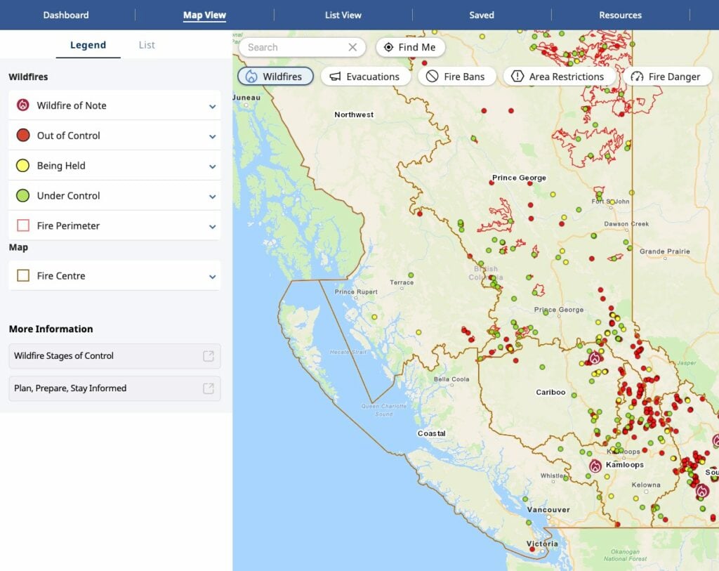
Look up the local state or provincial wildfire service to see if there are any fires in the area you plan to hike. Most agencies have an official website that lists wildfires, often with a map, fire bans and other resources to help you decide if it’s safe to go on your trip. Many also have official social media accounts on Facebook, Instagram and Twitter (now X) to announce breaking news.
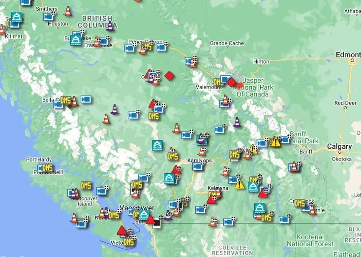
I like to look at these official map sources to figure out how big the fires are, and what trails or roads they have burnt or threaten to burn. Looking at where the fire actually is helps me plan.
Some official maps don’t have enough detail for hikers, so I often use Gaia GPS. It has two helpful layers you can add. The “Wildfires (Current)” layer pulls data from official government sources and the “Wildfires (Satellite Detection)” shows a matrix of dots over an area where satellites have detected heat.
This lets me overlay the fire maps on top of the trails and roads in the area I plan to hike. I’ve also heard that CalTopo has a good “Fire Activity Layer”.
State and Provincial Wildfire Agencies I use often:
- British Columbia Wildfire Service, especially their Wildfire Situation Map.
- Alberta Wildfire Status website and Wildfire Status Dashboard
- InciWeb Wildfire Map shows the status of major wildfires across the U.S.

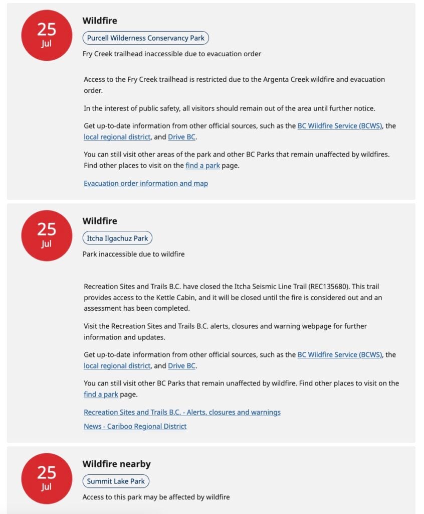
Park and Trail Websites
If there are trail closures or alerts, you’ll find them on official park and trail websites. Sometimes they are on the home page, but in other cases, you’ll need to look for current conditions pages or things marked “advisories” or “important bulletins”. You can also check their official social media pages.
If you don’t see the info you need on a park website, you can try calling them. This works best with National Parks and National Forests – provincial and state parks often do not have the resources to have phone lines. If you call, try to ask for the backcountry ranger office. People answering general info lines usually are unfamiliar with backcountry trails and are not helpful.
Don’t rely on All Trails, Google Maps, or other apps – the info in these places is often crowd-sourced and might not be officially verified. So a trail that is listed as open on All Trails or Google Maps might actually have a fire nearby.
Park and Trail Websites I use often:
- BC Provincial Parks and the BC Parks active advisories list.
- Recreation Sites and Trails BC list of closures.
- Alberta Provincial Parks Advisories
- Parks Canada Important Bulletins for Canadian National Parks and individual park Facebook pages
- Washington State Parks
- Individual National Forests like the Mount Baker-Snoqualmie National Forest
- Individual National Parks like North Cascades National Park.

Government Transportation or Highway Websites
In wildfire season, roads are often closed in dangerous areas. Check your travel route to the trailhead to make sure it is open. If your trip is multi-day, be careful if the road is open now but if a fire is close – the road might close while you are backpacking, trapping you.
Transportation websites I use often:
Weather Forecasts
There might not be a fire near where you are hiking, but the upcoming weather could change wildfire conditions. Check the weather forecast to see if thunderstorms are on the horizon since lightning can spark fires.
I also check to see if the forecast calls for hot, dry weather with high winds since that’s a situation where fires could spread quickly.
My guide to weather apps for hiking has details on where to find the best weather forecasts.
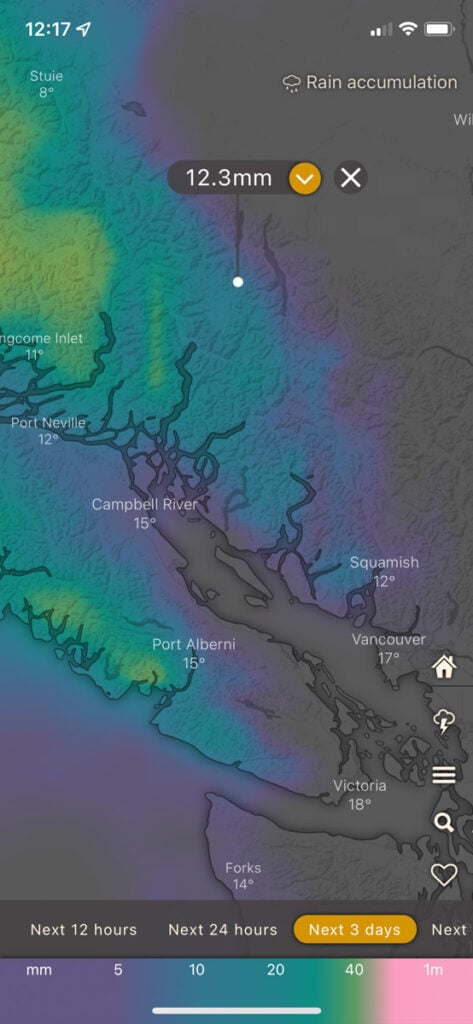
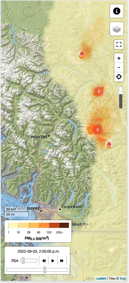
Air Quality Reports and Smoke Forecasts
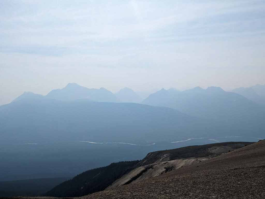
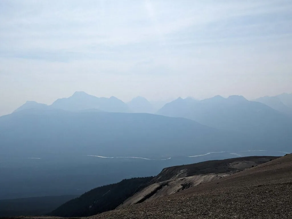
Even if there isn’t a fire nearby, hiking in smoke is really bad for your health. It’s also really unpleasant. In recent years huge fires in Canada have blown smoke as far away as the Eastern United States, so wildfire smoke can affect hikers anywhere.
I use FireSmoke to check the smoke forecast. It uses computer models to predict the ways that fire growth and winds will push smoke around. In my experience, it is usually pretty accurate.
It’s also important to check air quality reports. Many states, including Washington, have an air quality map, sometimes with a smoke forecast. There is also a national U.S. air quality report. Canada has a local air quality index, but it only covers major cities and towns.
I also like PurpleAir’s Real-time Map. It uses citizen science air quality monitoring stations so it has data from smaller towns. (We have a Purple Air reporting station at our house.)

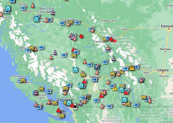
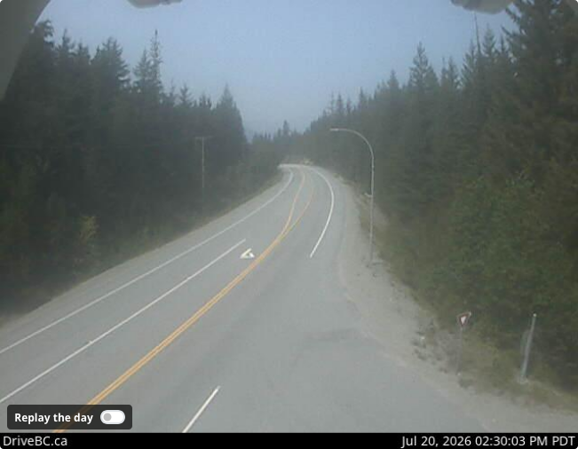
Web Cams
If you are looking for real time data on what the smoke is doing in an area you plan to hike, webcams can be really helpful. However, conditions can change quickly so I think it is only helpful to look at webcams the day before or day of your trip.
Since smoke can vary by elevation and with prevailing winds, webcams are the most helpful when they are located very close to where you want to hike and at a similar elevation.
Most highways and ski areas have webcams, but there are also tons of other webcams maintained by businesses, clubs, and private citizens. The easiest way to find webcams is to do a quick google search for the area you want to hike and the word webcam.
Make a Safe Hiking Plan
After you’ve checked to see where the fires are and what the smoke is doing, it’s time to make a plan for your hike.
Choose Your Trail Carefully
Checking conditions to see if fires are nearby is just one way to stay safe while hiking in wildfire season. Look at the trail you plan to hike. Does it head into forest fire danger terrain like thick dry brush or ridge tops? (More on danger zones in the Shelter In Place section below.) Is it a dead-end with no escape routes if a fire crosses the trail?
In the months/weeks/days leading up to your trip it’s also important to have a flexible mindset and a backup plan. If fire and smoke conditions aren’t right when it’s time to leave for your hike, switch to your backup plan or postpone your trip.
After you’ve chosen your trail, make sure you familiarize yourself with other trails in the area in case you need to hike out another way. Also look for places where you would be safe in case of wildfire such as lakes, meadows, or marshy areas. (More on these in Shelter in Place below.)
Bring a paper map or extra batteries for your GPS so that you can navigate on the fly in an emergency.
Inform Your Emergency Contact
Make sure you have an emergency contact who knows your trip plan including what trail you plan to hike and when you expect to be back. That way if you don’t return as scheduled, they can call Search and Rescue to look for you.
Your emergency contact should also be proactive about finding out fire info for you. If you have to contact them during an emergency, they can tell you which directions are safe(r) to hike to get away from a fire.
Register Your Hike
In some areas, wilderness permits or backpacking reservations are required. In other areas, there are optional trailhead registries. They often have a spot where you can fill out emergency contact information. Make sure your emergency contact person knows where you are going and has your trip plan.
In the devastating 2024 fires in Jasper National Park, rangers called the emergency contacts of backpackers to see if they had evacuated on their own and to get a handle on how many people still needed help in the backcountry.
Write Down Key Phone Numbers
Some parks have an emergency phone number you can call if you need help or info. Having this number could be crucial in an emergency. If the park doesn’t have an emergency number, having the phone number for the park info centre or backcountry ranger office is also great.
When I talked talked to Carol May, a hiker who evacuated from the Skyline Trail during the 2024 Jasper National Park fires, she said when they got to the trailhead and had cell service, they didn’t know which way was safe to drive. She says she wished the park had a dedicated emergency phone number to call like others she had visited. Instead, they flagged down a passing ranger on the road who gave them info.
Pack the 10 Essentials
You already bring the 10 essentials on every hike, right? Right?? These are key items you should pack for every trip in case you get lost or have an emergency situation. Your version of the 10 essentials doesn’t have to be heavy, bulky, or expensive – mine isn’t.
My guide to the 10 essentials explains each of the 10 items, plus one more I always carry. I also have specific gear recommendations.
Carry a Satellite Messenger
There is often no cell service on hiking trails. A satellite messenger could be the difference between life and death. I carry a Garmin inReach Mini 2 so I can check in with my emergency contact each night to let them know I am safe. They can also message me if there is any new fire info I need to know.
In the past, I’ve turned my inReach off each night to save battery. Now I’ve realized that I might want to leave my inReach off overnight in case I need to receive an emergency message. (But I’ll reduce the tracking frequency and turn off Bluetooth temporarily to save battery.)
Newer iPhones (iPhone 14 or later) have texting via satellite. I’ve tried it in the backcountry and it seems to work pretty well. However, my iPhone battery drains quickly and the inReach lasts for days, so I’m going to continue to bring my inReach on long trips.
During the Jasper wildfires, park rangers contacted hikers’ emergency contacts. Those people then messaged the hikers on satellite messengers. The hikers who received messages were crucial to spreading the word in campgrounds and on trails that they needed to evacuate.
Carry a Battery Charger
In an emergency you are going to want a fully charged phone so you can call for help. Even if you don’t have cell service on the trail, once you get back to the trailhead, you are going to need a phone to figure out which way to drive. It’s also good to have a way to charge your satellite messenger and headlamp.
Carol told me she was glad her phone was charged because during her evacuation, they stopped at a cafe near the trailhead at 4:30 am. It was closed, but they were able to access the wifi from outside to look up info on the fires online and decide whether it was safe to keep driving to continue their evacuation.
Bring a Reliable Headlamp
I often pack an ultralight headlamp on backpacking trips because I typically only need it to light the way to the outhouse in the middle of the night. I’m not worried about how long the battery will last or how charged it is.
But Carol recommends bringing a fully charged headlamp with a long battery life. She was glad her headlamp was charged when she had to evacuate at 2 am. She said charged headlamps were “absolutely critical if evacuating in the middle of the night. We needed them for hours.” She told me that other hikers they met were having trouble with theirs and she was lucky that hers was charged.
In a wildfire evacuation, you may have to hike in the dark for hours, so a fully charged headlamp with a long battery life could be crucial.
Pack a Mask
An N95 mask weighs a few grams and could make a huge difference if you end up hiking in thick smoke. Thanks to the pandemic, they are easy to source at pharmacies or online. In a pinch, putting a bandana or buff over your nose and mouth can also help.
What To Do If There is a Wildfire Nearby
If you’ve done your research before a hike, you shouldn’t be hiking anywhere near an active fire. However, fires can start quickly, so a new fire could pop up while you are on the trail.
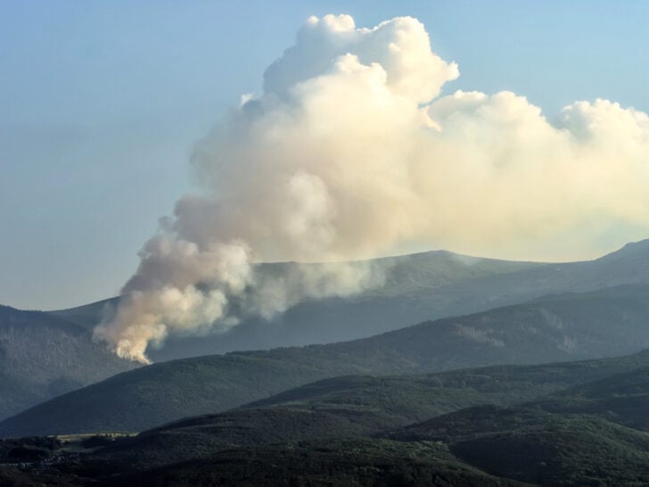
Wildfires Spread Quickly
Wildfires can spread incredibly quickly. According to sources, fires often spread at up to 10 km/6 miles per hour. They can move even faster if they are going uphill or if there are strong winds. You can’t outrun most wildfires.
As well, large fires make their own weather with high winds that spread the fire faster. Fires can also cause pyro-cumulonibmus clouds, which create thunderstorms, and therefore more fires from lightning strikes. For an informative (but terrifying) read, I recommend the book Fire Weather by John Vaillant about the devastating wildfires in 2016 in Fort McMurray, Alberta.
That means that if you spot a fire, you need to get away from it fast!
Which Way to Run?
Try to figure out where the wildfire is, then get away from it. That will be easy if there is smoke (or flames) in the distance. But if you find yourself surrounded by smoke, it’s a bit trickier – try to see if you can see which way the smoke is flowing.
Since fires travel uphill faster than downhill, avoid the tops of ridges and peaks. If there is smoke in the distance, assess which way the wind is blowing. If it is blowing towards you, the fire will be coming towards you too. Travel over recently burned land if you can. Just watch for falling trees and hot ash, which can melt your shoes.
Use your GPS and paper maps to assess the trails near you and decide which ones will take you to safety away from the fire.
Take enough supplies with you to stay safe. If it seems like speed is essential, you might want to ditch some gear so you can travel faster. Be sure to take the 10 essentials including food, water, water filtration, first aid supplies, a jacket, your phone, your satellite messenger, and and some form of shelter.
During Carol’s evacuation she says she wasn’t sure whether to leave her pack. “We took a few minutes to filter water and get snacks ready because we really didn’t know what the next hours or days would bring,” she said. She hiked the 12 km trail out to the parking lot in about 2 hours, but says some inexperienced hikers took substantially longer. Having the snacks and water definitely helped.
Get Help
If you have a cell service or are carrying a satellite messenger, use it. You can message your emergency contact if the fire looks like it is far away and have them look up info about the fire to help you decide how to proceed.
If the fire hasn’t been reported yet, report it by calling 911. You will need info about where you are and where you think the fire is. If possible, give the names of trails and geographic landmarks nearby. GPS coordinates are ideal.
If the fire is close, skip right to pressing the SOS button or calling 911 for help. You can also try signalling to passing planes and helicopters – they will be looking for hikers in the backcountry. This is also a good technique if you have been in contact with Search and Rescue and they are looking for you.
Direct a signal mirror or flashing headlamp at the aircraft. Move to an open area and use bright colours (especially red and orange) to attract attention. You can spread out your tent fly, tarp, or several bright jackets to attract attention.
I hate to say this because I hope it’s obvious, but don’t start a signal fire to help rescuers find you. You might just start another wildfire by accident.
Work Together With Other Hikers
Group up with other hikers to share information and supplies. During the 2024 Jasper National Park wildfires, hikers with satellite messengers alerted other hikers that the fire was getting closer (even though in some campgrounds it wasn’t smokey yet) and told them they had to evacuate even though it was 2 a.m.
If possible, try to keep track of how many hikers are with you and their names. You can give this info to park rangers after you evacuate. That park staff will know which hikers evacuated and which ones they still need to locate.
Shelter in Place
If the fire is close, you will need to shelter in place. In general, get low to the ground to avoid the smoke. You can dig a hole in the dirt for your face. Hide behind something big (like a rock) that won’t catch fire.
Here are some tips on good places to shelter versus bad places to shelter.
Good Places to Shelter:
- Places with less vegetation like rock fields, swampy areas, and meadows – but avoid these areas if they are next to a place with dense vegetation
- Flat areas
- Lakes – you can get into the water and hide behind rocks or islands. Murky water is better than clear water because it is better at blocking radiant heat.
Bad Places to Shelter:
- Thick forests
- Steep areas (because fire travels uphill)
- Chutes, ravines, and saddles (low spots on a ridge) – these are natural travel paths for fire
- Ridge tops (because fire travels uphill and you won’t have an escape route)

How to Prevent Wildfires
Unfortunately, humans cause many wildfires – in BC about 40% of wildfires are human caused. Most of the time, people don’t mean to start a fire. With a bit of knowledge and preparation, you can avoid being part of this statistic.
Skip the Campfire
With frequent fire bans, I rarely have a campfire anymore. I know many people feel like they have to have a campfire when camping to have the full experience, but if you skip it, you might find that you’re not missing out on much.
On hot summer days, campfires aren’t needed for warmth. Compared to a camp stove, campfires are unreliable for cooking (everything comes out charred or raw when I try it!). The smoke gets into everything – your clothing, hair, and eyes – and the stink lingers. And spending tons of time chopping firewood and tending the fire takes away from time you could be hiking, swimming, or relaxing.
Instead of campfire, I like to bring a simple battery powered lantern to gather around. Card games or portable board games can be fun too. And you can make s’mores in a skillet on your campstove.
If you must have a campfire-like experience, invest in a propane fire pit. They allowed during fire bans in most jurisdictions are are much easier to use and safer than a campfire.
Check for Fire Bans
Before you have a campfire, check to see if it is allowed. Many provinces and states have websites that show where campfires are allowed and not allowed. However, you should also check park and local municipality websites since some areas have stricter regulations about fires than the province or state. For example, Garibaldi Provincial Park, near where I live, bans fires year round since the park has a sensitive alpine ecosystem.
State and Provincial Fire Ban resources I use often:
Have a Safe Campfire
If you do have a campfire, check the weather first. Avoid having a campfire on windy days when embers can blow into grass, trees, or buildings and ignite them.
Keep your campfire small. Small campfires are less likely to get out of control.
Use a metal fire ring to keep your fire contained. If you build your fire on bare ground, you can ignite underground root systems, which can spread the fire to the surrounding trees and bushes. Underground fires can smoulder for days or weeks, emerging into flames much later.
Only build a campfire if there is a reliable water source nearby. If your fire gets out of control, you will need a lot of water to put it out. The water in your water bottle won’t be enough. You’ll need running water or a nearby lake or stream to put it out.
Make sure your fire is out. Many people let their fire burn out and think that is good enough. It isn’t. Coals and embers can ignite hours later. When you’re done with your fire, douse it with water, then stir. Keep dousing and stirring until the coals are cool to the touch.
Be Careful When Smoking
Cigarette butts and other smoking materials can cause wildfires, especially in dry and windy conditions. We recently had a fire about 1.5 km from my house in Squamish. The local rumour is that is was started by mountain bikers smoking weed on a dry grassy section of trail.
Dispose of cigarette butts and joint roaches safely. My friend used to smoke and had a fireproof ashtray pouch to pack out cigarette butts. You can also use an Altoids tin or similar.
Drive Cars and ATVs With Care
Hot mufflers and sparks from vehicles can ignite dry grass and other flammable natural materials. Ensure your vehicle is properly maintained to avoid throwing sparks from dragging parts or chains, which can throw sparks. And avoid driving in tall grass, which can catch fire when it touches a hot muffler or exhaust pipe.
Final Thoughts
While it can be devastating to have a trip you’ve planned for a long time get cancelled due to wildfires or smoke, the forest will grow back and you can hike it another time. Don’t risk your life (or your lungs) and the lives of first responders by hiking near wildfires.
READ NEXT:
- The Best Weather Apps for Hiking
- Tips for Hiking in Hot Weather
- How to Find Trail Conditions
- The 10 Essentials: Things You Should Bring on Every Hike
- 16 Things to do Before a Hike


- Best Sun Hoodies for Hiking - June 3, 2026
- Lower Stein Valley Trail Hiking and Backpacking Guide - May 27, 2026
- The Best Things to Do in Vernon, BC - May 21, 2026
Carol
Wednesday 23rd of July 2025
good job putting this together and even adding the note about the N95. I gave a gal my spare N95 at Reds Meadow in Mammoth many years ago and she later said that is the only way she finished the trail (she was going NB)