

Heads up: The Berg Lake Trail was closed for a few years, but it reopened on June 26, 2025. There are a few rerouted sections – details are in the trail description below.
The Berg Lake Trail in Mount Robson Provincial Park is one of Canada’s premiere multi-day hiking trips. People travel from all over the world to do this trip. We met Americans, Austrians, Mexicans… oh and a bunch of Canadians from all over the country.
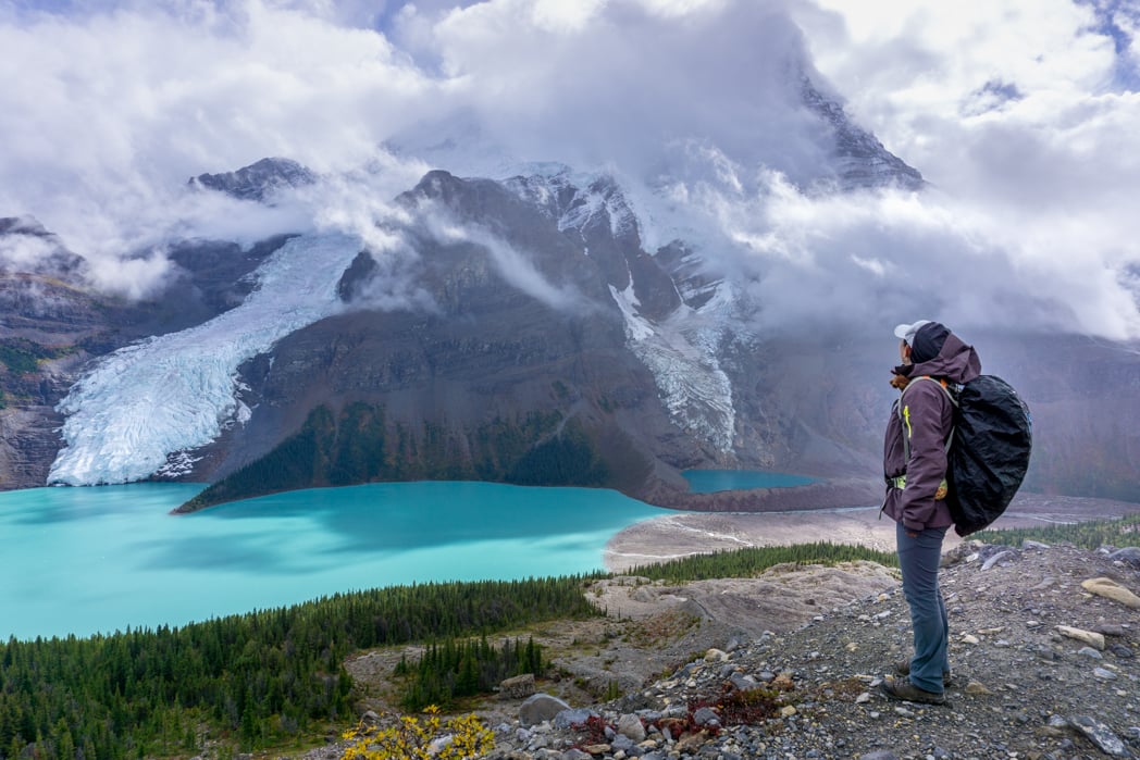
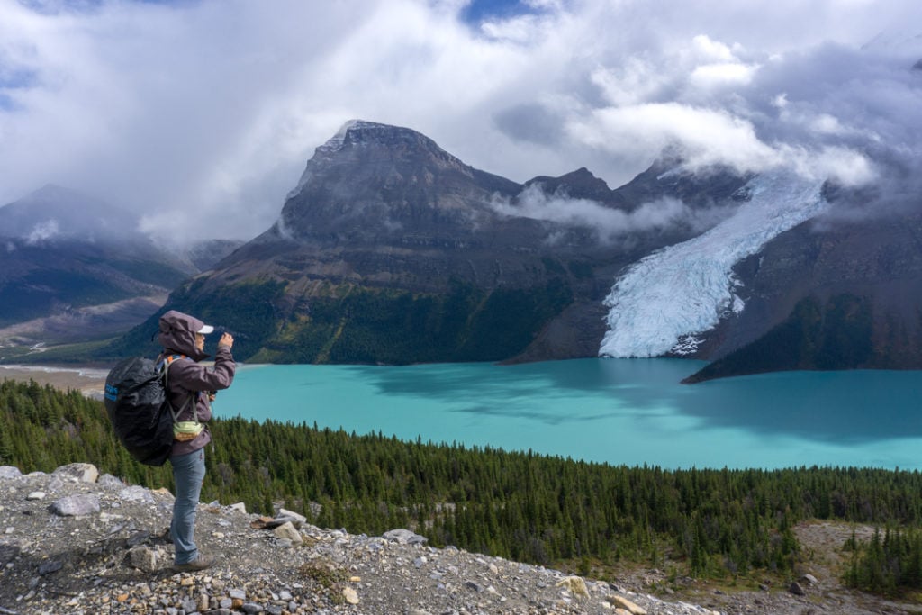
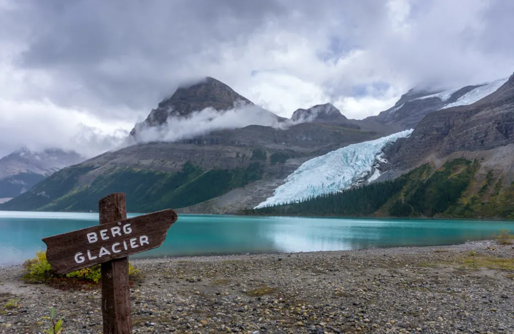
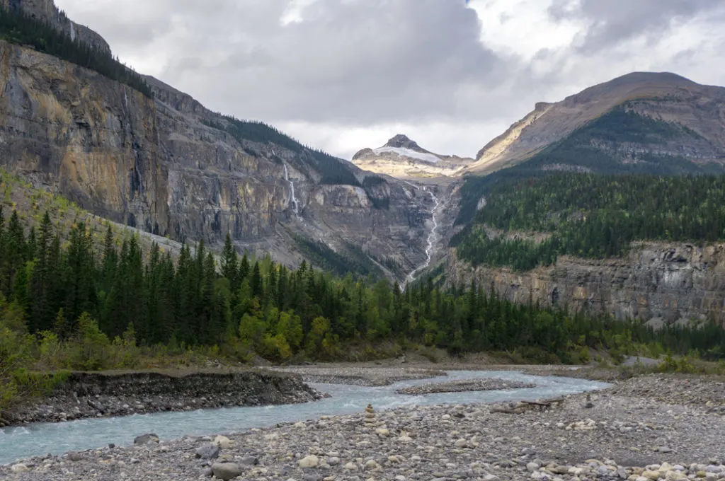
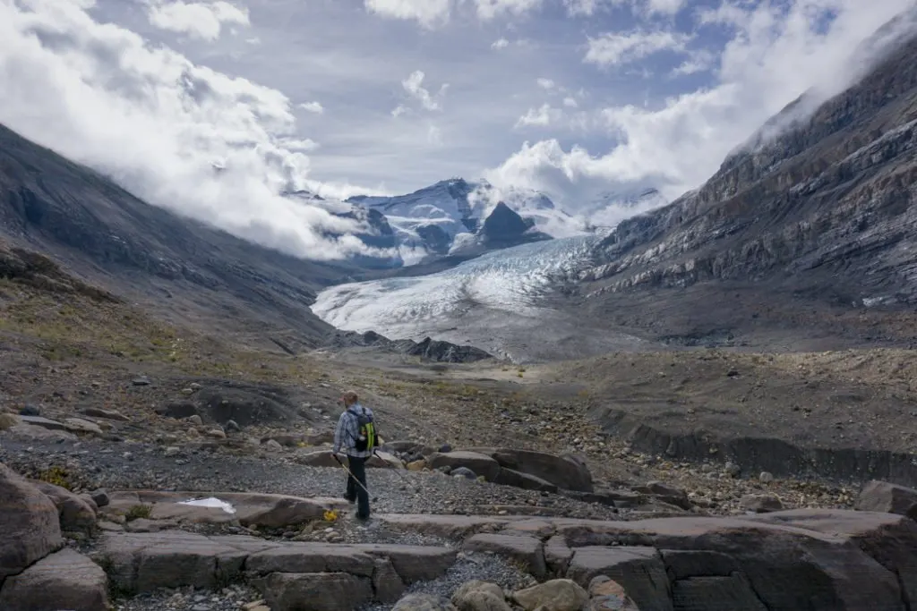
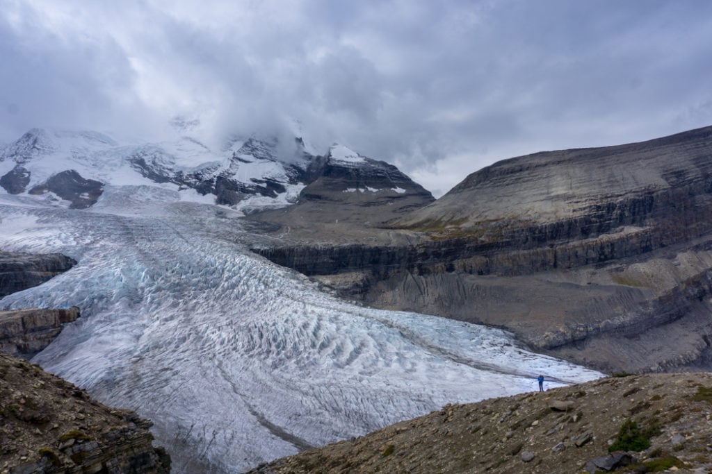
It begins down in a temperate rain forest before climbing high up into the alpine to a brilliant blue glacier-fed lake. And speaking of glaciers! So many glaciers! The star of the show is the Berg Glacier, tumbling down the slope of Mount Robson into the lake. Oh, and BTW, Mount Robson is the highest peak in the Canadian Rockies. There’s lots of awesome stuff going on with this trail!
A few years ago, I finally made the drive to the Rockies to hike the Berg Lake Trail. We spilt up our hike over 5 days so we’d have lots of time to enjoy the scenery and to go on day hikes from our base at Berg Lake Campground.
In this post I’ll tell you everything you ever wanted to know to plan your own trip. Because believe me, after seeing these photos, you’ll want to go.
A quick note: The info in this post was written for trail conditions prior to the 2021 washout. Where possible, I’ll make a note of areas where the trail is different after the 2025 re-opening. I haven’t hiked the new trail yet, but I’ve summarized info from BC Parks and people who have hiked it since it’s been open to indicate what parts of the trail have changed.
This is a sensitive wilderness area. Learn how to Leave No Trace to keep the wilderness wild. Make sure you are prepared by bringing the 10 Essentials. Get ready for adventure with this checklist of things to do before every hike.
Hey there: Some of the links in this post are affiliate links, which means I earn a small commission at no extra cost to you if you make a purchase. Thanks for supporting my website! -Taryn
Berg Lake Trail Basics
Distance: 21km one way
Elevation Gain: 800m
Time: At least 2 days. I recommend 4 or 5.
Cost: $10/person/night plus reservation fees of $6/tent pad/night (up to a max of $18)
Best Time to Go: The trail is snow-free from June to September. Best time to hike is July to early September.
Difficulty: Moderate, especially if you split the ascent to Berg Lake over two days.
What to Bring: I’ve got a complete Berg Lake Trail packing list for you.
Location: Mount Robson Provincial Park in the Canadian Rockies, 1 hour west of Jasper.
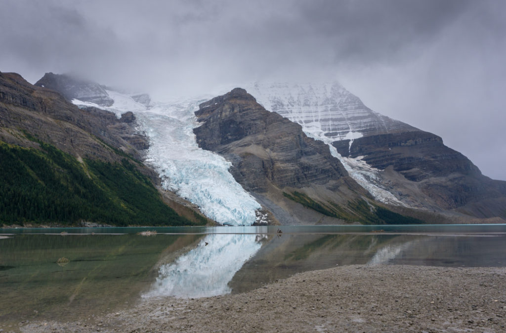
Description: The trail follows the Robson River. Along the way you’ll pass by Kinney Lake before climbing steeply up through The Valley of A Thousand Falls. At the top of the valley, the trail levels out and follows the river to the shores of Berg Lake. Mount Robson, the highest peak in the Canadian Rockies at 3954m (12,972ft), towers over Berg Lake. The Berg Glacier cascades down the side of the mountain into the lake where it breaks off and forms icebergs. (And that’s why it’s called Berg Lake!)
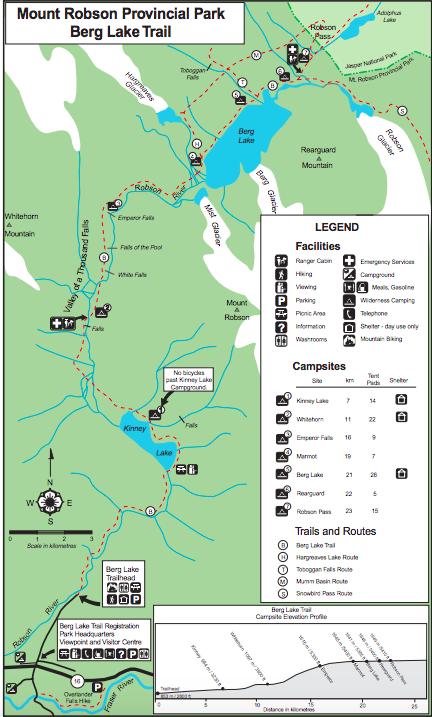
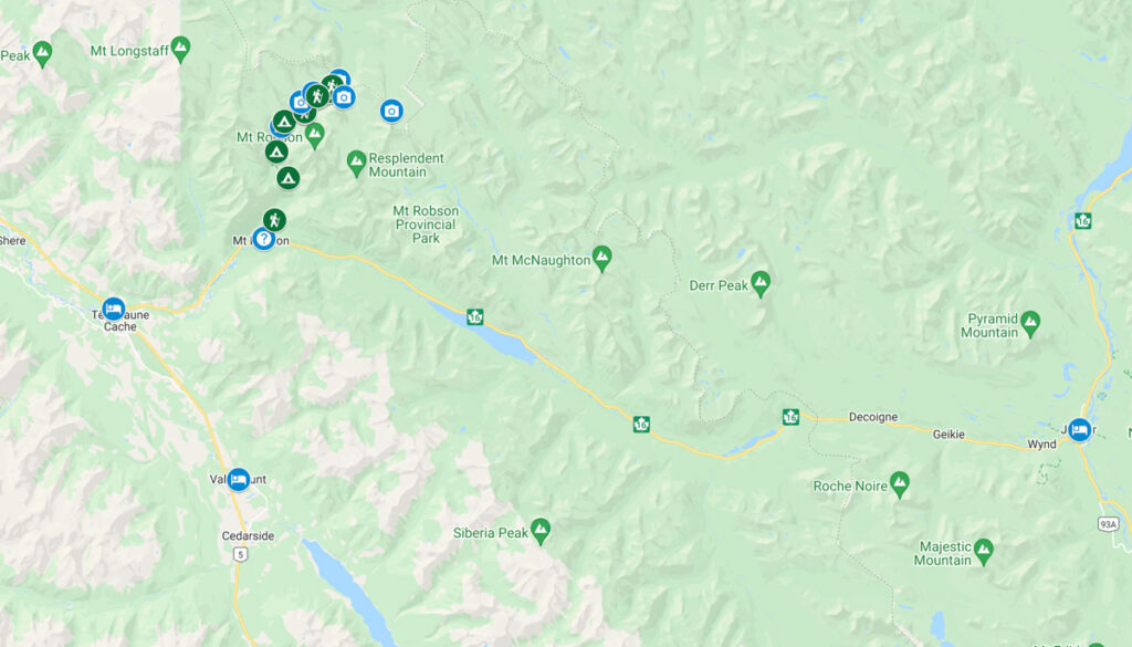
Berg Lake Trail Map
The Berg Lake trail is well marked and easy to follow. There are frequent info signs and maps so it’s almost impossible to get lost. Unless you plan to travel off-trail in the backcountry, the map below is the only one you’ll need for the Berg Lake Trail. Click on the map below to view a printable PDF. Print out the map, then tuck it inside a ziploc bag for use on the trail.

When to Go

The trail is usually snow-free from June until late September. However, some years the snow can linger into early July or start to fall again in late September. I hiked the trail in early September 2018 and we got hit with a snow storm on our last day! July and August have the best weather, but the trail is also the busiest during those months.
If you want to day hike the Snowbird Pass trail, you should know that it is closed until July 1st each year to protect the caribou calving grounds.
READ NEXT: The Best Weather Apps for Hiking
How Long to Spend on the Trail
In my opinion, most people will want to spend about 4 or 5 days on the trail.
Here’s an itinerary I recommend: Day 1: Hike to Whitehorn campground. Day 2: Hike to Berg Lake campground. Day 3: Day hike to Snowbird Pass. Day 4: Hike to Whitehorn or Kinney Lake campground OR hike out to the trailhead. Day 5: Hike out to the trailhead if you stopped at Whitehorn or Kinney.
The trail is 21km one way (42km return). It’s possible to hike up to Berg Lake and back in one day, but it would likely take over 14 hours. I don’t recommend it and the vast majority of people spend at least one night on the trail.
Since it is a 21km hike in with 800m of elevation gain, many people split the ascent to Berg Lake into 2 days. If you’re in good shape and an experienced backpacker, you could hike all the way to the lake in 1 day.
The same goes for the descent: you can do it in one day, but many people prefer to split it into two days.
If you want to do any of the day hikes at Berg Lake, you’ll also want to allow time for that. At a minimum, you should do the Snowbird Pass hike – it’s gorgeous! Scroll down to the bottom of this post to read more about day hikes at Berg Lake.
Weather and Climate

Berg Lake is at an elevation of 1640m (5410ft). It sits right next to Mount Robson, the highest peak in the Canadian Rockies. Mount Robson is so tall that it makes its own weather. This means that it is often rainier at Berg Lake than other places in the Rockies. It also is high enough in the mountains that it can snow in any month.
The temperature can also vary a LOT at Berg Lake. On sunny summer days highs up of up 30C (86F) are possible, with the temperature dipping to less than 10C (50F) at night. On rainier days or in June and September the highs are more like 15C (59F) with lows of 0C (32F) at night. Of course the temperature can often be much colder than that, so bring warm clothing.
READ NEXT: How to Stay Warm in a Tent: Over 40 Tips
Costs and Reservations
The Berg Lake Trail is really popular and people come from all over the world to hike it. To manage the crowds, the park rangers have made all campsites on the trail 100% reservable between mid-June and the end of September.
Previously, reservations opened on October 1st the year before your trip. However, since the trail suffered a big washout in 2021, the full trail has not been open. In 2025, the full trail was open for the first time since the 2021 storms.
Reservations for summer 2026 opened on Tuesday December 2, 2025 at 7 am. You need a reservation for stays between May 27 and September 29, 2026.
Thankfully, the reservation fee isn’t too expensive: It’s $6 per tent per night, up to a maximum of $18.
When you make your reservation you’ll also need to pay backcountry camping fees. Those are $10 per person per night. You can make reservations through the BC Parks reservation service. For more info on how to navigate the online reservation system, see my guide to making backcountry reservations in BC.
To hike the trail you will need a permit. Take a print-out or screen shot of your reservation confirmation email to the Mount Robson visitor centre on the day you start your hike. The rangers there will give you a laminated permit tag to take with you on the trail.
Starting in 2026, you also have the option of staying in the new Alpine Club of Canada Byron Caldwell Hut, also known as the Robson Pass Hut. The hut is still under construction, but will be open from May 22 to October 11, 2026. The hut costs $60 to $70 per person, per night. I’ve got more info on the hut in the camping section below.
READ NEXT: How to Make Backcountry Camping Reservations in BC
How to Get to the Berg Lake Trail
The Berg Lake Trail is located in Mount Robson Provincial Park in the Canadian Rockies. It’s located just over the BC/Alberta border from Jasper National Park. It is in the Pacific time zone.
The closest towns to the trail are Jasper, Alberta (1 hour to the east along highway 16), and Valemount, BC (30 minutes to the south west via highway 16 and highway 5). Click here for Google maps driving directions.
You can also hike the Berg Lake Trail without a car: Take Ebus from Edmonton, Vancouver or Kamloops to the Mount Robson Visitor Centre. Then walk 2.2 km to the trailhead. (That’s why Berg Lake is on my list of the best car-free backpacking trips in BC.)
If you are flying in, the closest airports are Edmonton and Kamloops, both of which have car rentals. You can also rent a car in Jasper. I use Discover Cars since it lets you compare prices from lots of different rental companies. That way you know you are getting the best deal.
You will probably want to stay near Mount Robson Provincial Park the night before so you can get an early start on the trail. We stayed at a cabin in Tete Jaune Cache since it is about 15 minutes east of the visitor centre. If you want a hotel, you can book accommodation at bit farther away in Jasper or Valemount. If you want to camp, there are car campgrounds in the provincial park near the visitor centre.
What to Bring
You will need to be totally self-sufficient on the trail and carry in everything you will need for your trip – right down to the toilet paper!
To avoid carrying a stupidly heavy pack, choose lightweight backpacking gear rather than heavy conventional camping gear. The weather in the mountains is also often very cold and wet so be sure to pack accordingly. For a full list of what to pack, see my complete Berg Lake Trail packing list, with specific gear recommendations.
READ NEXT: What to Pack for the Berg Lake Trail
Rules
The Berg Lake trail is a popular area and it is also environmentally sensitive. As always, be sure to Leave No Trace. The park rangers have put a few rules in place to protect the area.
Dogs: Allowed on leash for day hikes only. No dogs are allowed on overnight trips.
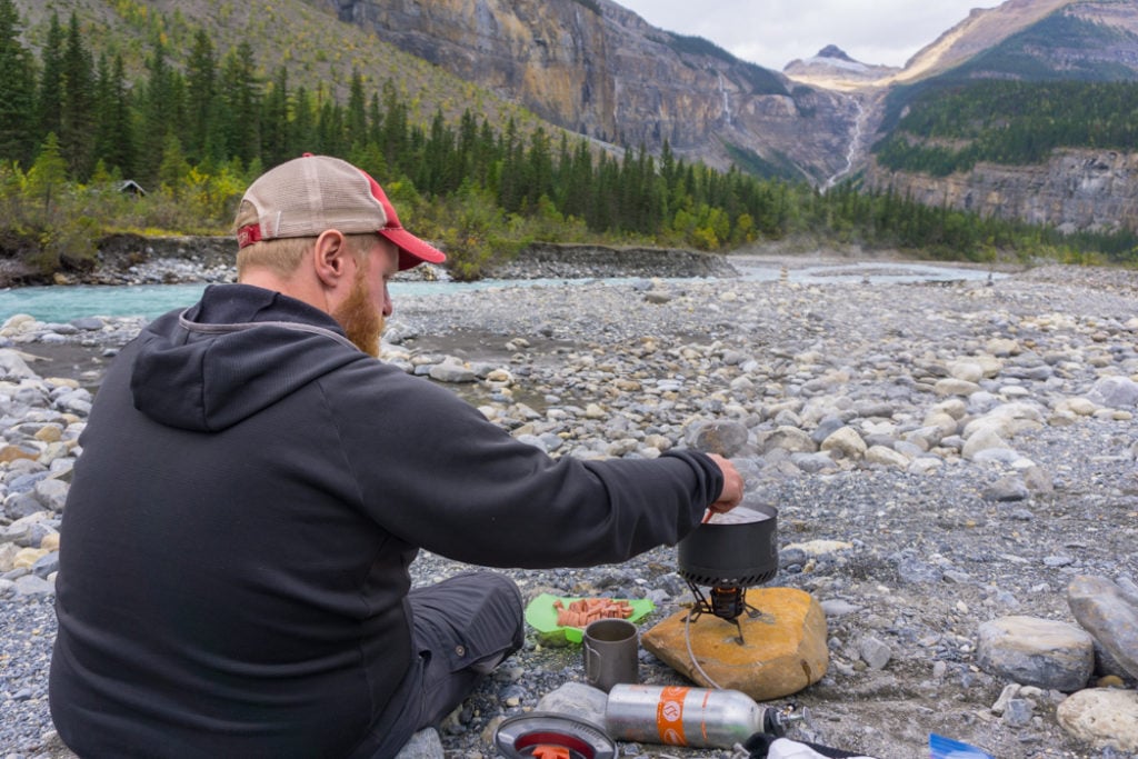
Fires: No fires are allowed. Bring a camp stove for cooking. There are wood stoves in the shelters at the Whitehorn and Berg Lake campsites, but they can only be used in an emergency.
Bikes: You can bike the first 7km of the trail to the end of Kinney Lake but you aren’t permitted to bike further than that. E-bikes are allowed. If you are comfortable biking with an overnight pack, using a bike for the first section could make your trip a little faster.
Helicopters: If you have the cash, you can pay to fly in to Robson Pass on a helicopter from Valemount. The helicopters are only allowed to land on Mondays and Fridays.
Hammocks: Not permitted as they can damage the trees. (The trees aren’t very big up in the alpine.)
Maximum Group Size: 12 people to minimize impact.
READ NEXT: How to Leave No Trace (And Why it’s Important!)

Trail Overview

Key Distances
| KM | Elevation | Landmark |
|---|---|---|
| 0 km | 853 m | Trailhead |
| 4.2 km | 984 m | Kinney Lake bridge |
| 7 km | 984 m | Kinney Lake campground |
| 8.5 km | 1000 m | New Whitehorn hill bridge |
| 11 km | 1097 m | Whitehorn campground |
| 13 km | 1220 m | White Falls |
| 14 km | 1370 m | Falls of the Pool |
| 15 km | 1550 m | Emperor Falls side trail |
| 16 km | 1615 m | Emperor Falls campground |
| 19 km | 1645 m | Marmot campground |
| 19.2 km | 1645 m | Hargreaves Lake Trail fork |
| 21 km | 1641 m | Berg Lake campground |
| 21.1 km | 1641 m | Toboggan Falls Trail fork |
| 22 km | 1646 m | Rearguard campground |
| 22.3 km | 1646 m | Snowbird Pass Trail fork |
| 23 km | 1649 m | Robson Pass campground AND Mumm Basin Trail fork |
| 24 km | 1650 m | ACC Robson Pass Hut (Byron Caldwell Hut) |
| 24.2 km | 1655 m | Jasper National Park boundary |
Starting the Trail
To start the trail you need to sign in at the Mount Robson visitor centre. It’s located on highway 16 in Mount Robson provincial park. Opening hours are 8am to 7pm 7 days a week in the summer. Bring a print out or screen shot on your phone of your reservation confirmation to show the rangers.
The rangers will give you a brief orientation and go over some safety info and park rules. You will also need to head down to the basement to watch an orientation video. The rangers will give you your laminated permit tags (one for each tent). Hang them on your backpack while you’re hiking and your tent when it’s set up. The rangers may ask to see them on the trail.
The trailhead is located 2km from the visitor centre. There’s a parking lot with a covered picnic shelter and an outhouse at the trailhead. If you’re worried about leaving things in your car while you hike, the visitor centre has lockers for rent.
Trailhead to Kinney Lake Bridge
Distance: 4.2km | Elevation Gain: 150m | Time: 1-2 hours | Difficulty: Easy
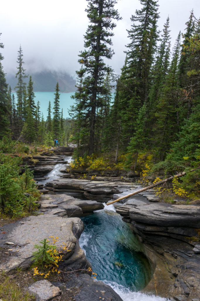
The trail starts with a wide bridge across the Robson River. There’s a large info board with a map. This section of trail is an old gravel road that climbs steadily uphill but is never steep. In some places the trail is quite close to the rushing river. You’ll be walking through a temperate rain forest with lots of big cedars, hemlocks and ferns. There are a few interpretive signs along the way.
After 4.5km you’ll reach a wide bridge crossing the Robson River at the outlet of Kinney Lake. This bridge was replaced as part of the trail work after the 2021 storms.
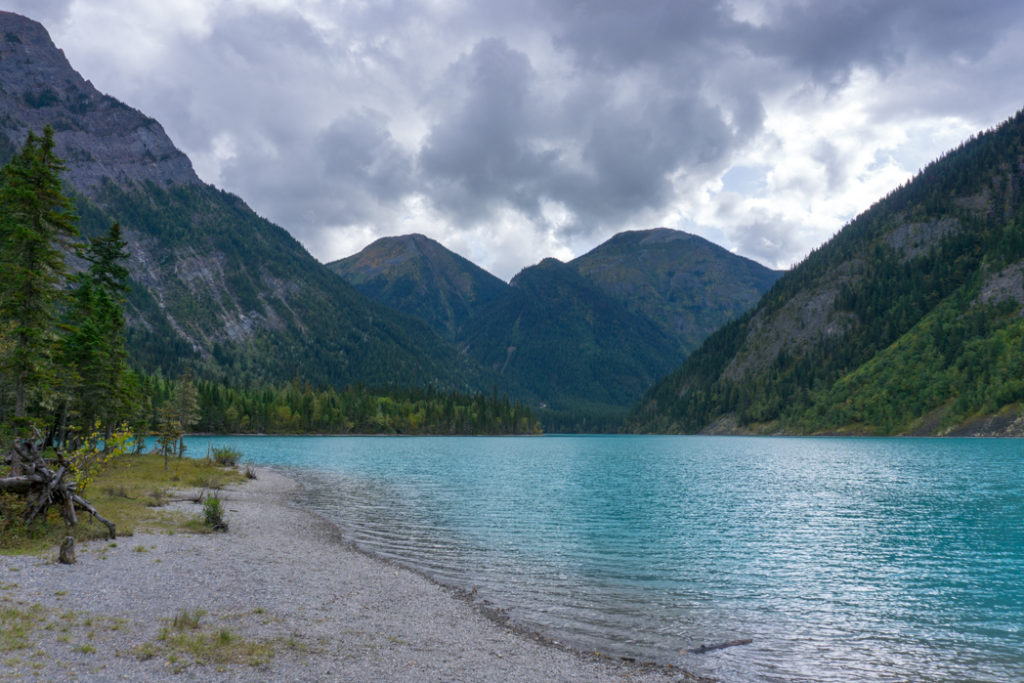
Kinney Lake is a beautiful light blue colour thanks to the glacial sediment in the water. There is a 4 way intersection on the far side of the bridge. Go right for an outhouse. Turn left for a short side trail that leads to a picnic area. Stay straight to remain on the Berg Lake Trail.
Kinney Lake Bridge to Kinney Lake Campground
Distance: 2.8 km | Elevation Gain: 30 m | Time: 40min-1 hour | Difficulty: Easy
After Kinney Lake bridge the trail stops looking like a road and more like a trail. It heads through the forest and then climbs a small hill on some short but steep switchbacks. You’ll get some peek-a-boo views of Kinney Lake before dropping right back down to lake level again.
The trail crosses a gravelly section next to the lake before heading back in to the trees. Soon you’ll arrive at the Kinney Lake Campground with its open-sided shelter.
Kinney Lake Campground to Whitehorn Campground

Distance: 4 km | Elevation Gain: 100 m | Time: 1-2 hours | Difficulty: Moderate
A few minutes past Kinney Lake campground you’ll reach the end of Kinney Lake. There’s a bike rack here since this is the furthest you’re allowed to ride a bike.
This section was heavily washed out in the 2021 storms and has been repaired. Follow trail signs here to stay on the restored trail. Follow the trail past gravel river flats. Ignore a side trail to the site of a former bridge over the Robson River and continue on the new trail upstream for 0.5 km to a new bridge.
Cross the bridge over a tributary of the Robson River and continue on the new trail as it works its way uphill on switchbacks on the east side of the river. At times you will be high above the canyon.
As the trail starts to flatten out, you’ll arrive at Whitehorn Campground on the banks of the river.
Join the Backpacking in BC Facebook Group
Whitehorn Campground to Emperor Falls Campground

Distance: 5 km Elevation Gain: 520m Time: 2.5-4 hours | Difficulty: Hard
The next section of the trail is new. From camp, cross the bridge over the Robson River and head uphill into the forest. The trail follows the 1150 m contour for about 1 km, so its fairly flat.
Cross a bridge over a tributary of the Robson River in an area of gravel flats, and then follow the trail back to the banks of the Robson River. From here, you’ll join up with the old trail through the Valley of a Thousand Falls.
This tight gorge channels the Robson River rapidly downhill. This means you’ll be doing a lot of steep climbing in this section of trail! You’ll gain 500m over 5km! This is also the only section of the trail where you won’t encounter any water sources, so be sure to fill up your water bottles before you head up the hill.
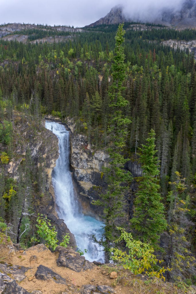
After the first few switch backs you will reach a viewpoint over White Falls. Continue steadily uphill in the forest for another kilometre to Falls of the Pool viewpoint. Past here the trail emerges from the forest and travels near the edge of the canyon.
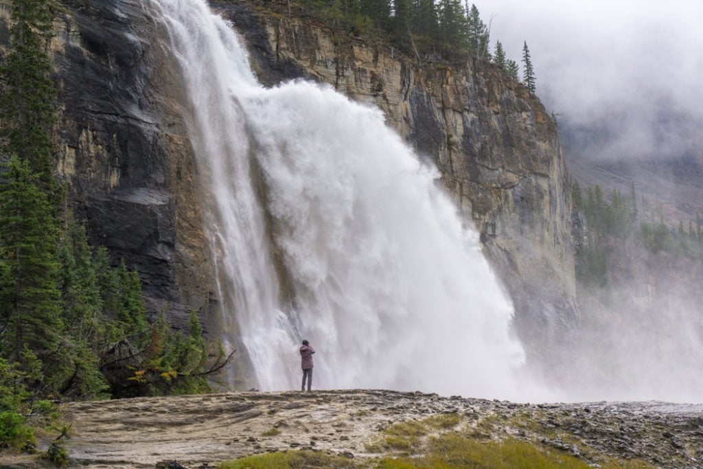
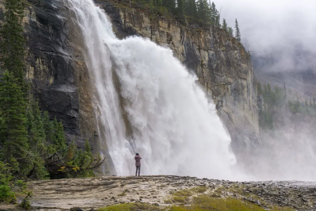
Eventually you will reach a signed junction with a side trail to Emperor Falls. The sign says it is a 500m walk, but don’t worry, it’s only about 200m each way. (I measured!)
You might be tempted to leave your heavy backpack at the junction. However, the park rangers want you to take them with you since the food inside can attract animals. Be sure to take the side trail to the falls since they are spectacular! You’ll definitely get hit with spray so wear a rain jacket.
Past the Emperor Falls junction you’ll continue walking uphill for another half kilometer to reach the Emperor Falls campground. The campground isn’t actually anywhere near Emperor Falls, but it is located right next to the beautiful Robson River.
Emperor Falls Campground to Marmot Campground
Distance: 3 km | Elevation Gain: 30m | Time: 45min-1 hour | Difficulty: Easy
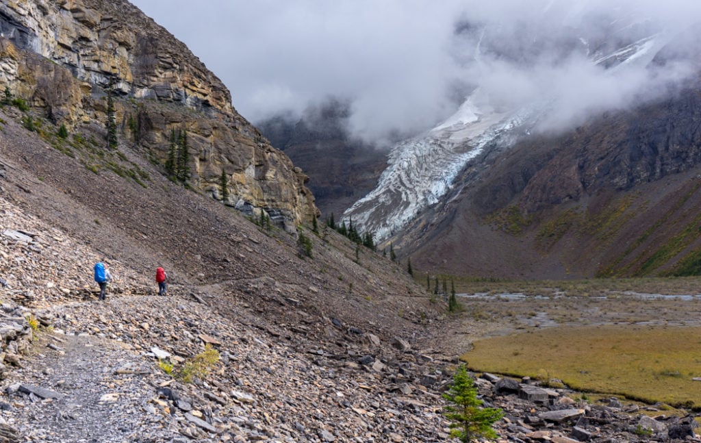
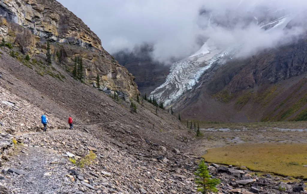
Shortly after Emperor Falls camp, the trail curves away from the river and traverses a rock slide. The trail builders did an amazing job across the rock slide: The path is remarkably smooth and they have built some great retaining walls.
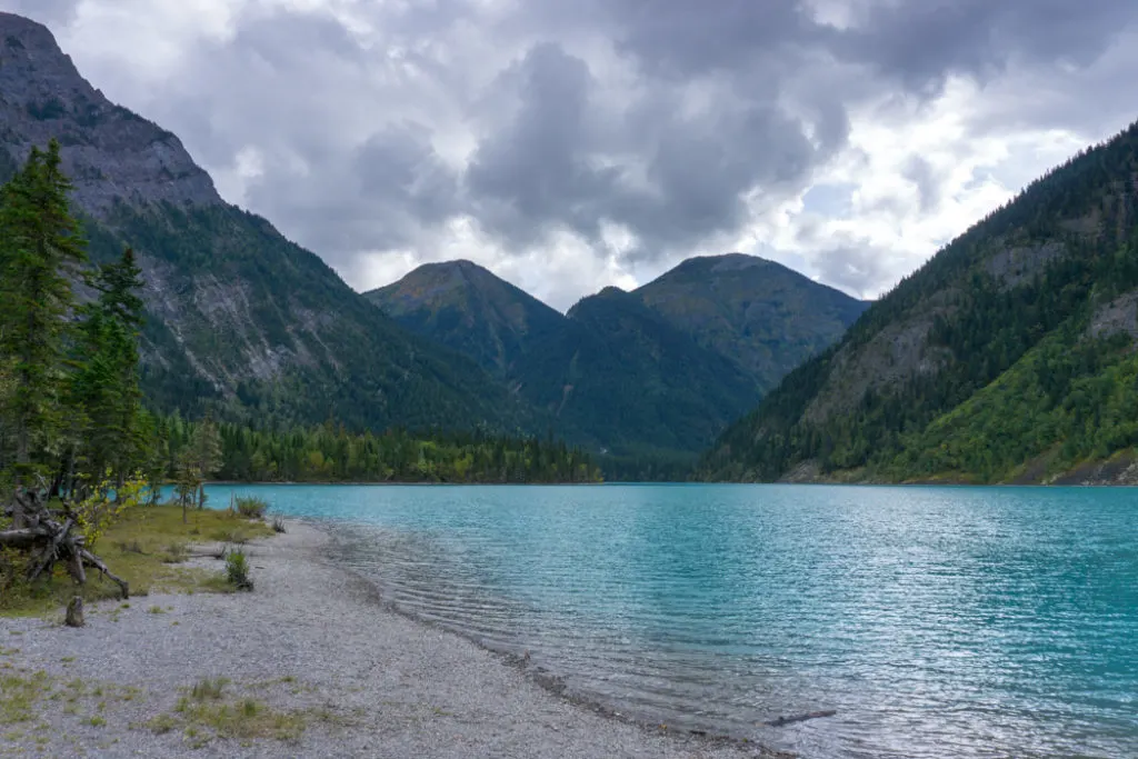
After the rock slide the trail goes down to another river flats section. This section has been rerouted since the 2021 storms. You’ll start to get views of the lake and the dirt-speckled Mist glacier. As you finally reach the shore of Berg Lake, you’ll arrive at Marmot Campground and get your first good views of the Berg glacier as it runs down into the lake.
Marmot Campground to Berg Lake Campground

Distance: 2 km | Elevation Gain: 0m | Time: 30-40min | Difficulty: Super easy
This flat section of trail follows the lakeshore between the Marmot and Berg Lake campgrounds. A few hundred meters after leaving the Marmot Campground you’ll pass the intersection for the Hargreaves Lake trail.
The trail is often a few meters above the lake level and there are a couple of great places to stop and look at the Berg glacier through the gaps in the trees. As you approach the Berg Lake campground there will be a side trail heading uphill to the campsites. Stay on the main trail for the fastest route to the shelter.
Berg Lake Campground to Robson Pass
Distance: 3.2 km | Elevation Gain: 15 m | Time: 30-40min | Difficulty: Super easy
After leaving the Berg Lake campground, the trail crosses a bridge. The trailhead for Toboggan Falls is right after the bridge. The main trail continues on through the forest and some river flat sections.
One kilometer from the Berg lake campground you’ll pass the Rearguard campground. A few hundred meters after that, look for the junction for the Snowbird Pass trail on your right.
Soon you’ll pass a ranger cabin, then arrive at the Robson Pass campground. This is the last campground on the Berg Lake trail, so most descriptions stop here, but the trail actually continues on. Right after the campground is the junction with the Mumm Basin trail.
A few hundred metres further, you’ll arrive at the ACC Robson Pass Hut, also known as the Byron Caldwell Hut. This hut is scheduled to open in May 2026. Past there, the trail heads over Robson Pass, then goes downhill into Jasper National Park in Alberta.
Join the Backpacking in BC Facebook Group
Camping on the Berg Lake Trail

| Campground | KM | # of sites/bunks | Elevation | Shelter |
|---|---|---|---|---|
| Kinney Lake | 7 | 18 | 984m | Open sided |
| Whitehorn | 11 | 22 | 1097m | Open sided |
| Emperor Falls | 16 | 9 | 1615m | None |
| Marmot | 19 | 7 | 1645m | None |
| Berg Lake | 21 | 26 | 1641m | Log cabin |
| Rearguard | 22 | 6 | 1646m | None |
| Robson Pass | 23 | 15 | 1649m | Lean-to |
| ACC Robson Pass Hut | 24 | 12 | 1655 | Enclosed Hut |
Campground Amenities
Outhouses
Each campground has at least one outhouse. (The bigger campgrounds have two or three). Toilet paper is not supplied so be sure to bring your own.
READ NEXT: What to Pack for the Berg Lake Trail
Tent Sites
There are a mix of raised wooden platforms and dirt tent pads on the Berg Lake trail.
When you make a reservation, you reserve which campground you will be staying in, but you don’t reserve any particular site. If you get to the campground earlier in the day you’ll have a choice of empty sites.
And FYI: you must stay only in the campgrounds you have reserved or you will be taking up a spot that someone else has reserved. The rangers will check and ask you to leave.
Food Storage Lockers
There are large metal lockers at each campground. Be sure to store your food and toiletries inside to protect it from animals, including bears. All campers share the lockers so put all your stuff in bags to keep it organized and to leave space for others.
Never leave garbage behind in the food locker – pack it out with you.
READ NEXT: Bear Safety for Hikers, Campers and Backpackers
Wash Stands and Grey Water Disposal Pits
The Berg Lake Trail is so high trafficked that the park rangers have installed wash stands and grey water pits to try to keep dishwashing water out of the lake and streams.
All the campsites have a marked grey water pit where you can pour your dishwater or strain the water out of your pasta. Many also have a wooden wash stand that comes with a plastic wash basin you can do your dishes in.
Picnic Tables
The smaller campgrounds all have at least one picnic table. The larger campgrounds have more. Many of the picnic tables have a metal overlay at one end. If you’re going to cook on the tables, put your stove on the overlay to avoid damaging the wood.
It’s also worth noting that you’ll need to share the picnic tables with other campers. At breakfast and dinner times if you aren’t actively cooking or eating, leave the table someone else can use it.
Shelters
There are a few day use shelters on the trail. The shelters are for cooking and hanging out. You aren’t allowed to sleep in them.
The Whitehorn and Kinney Lake campgrounds have large roofed shelters with open sides and four picnic tables inside. These shelters protect you from the rain but still let the wind blow in from the sides. The Whitehorn shelter has a wood stove but you are only allowed to use it in an emergency.
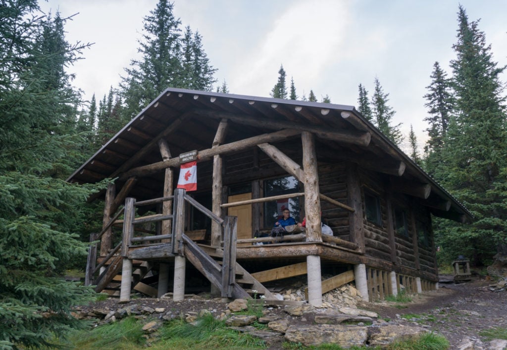
You’ll find the Hargreaves Shelter at the Berg Lake campground. This fully enclosed log cabin shelter started its life as part of a horse outfitters camp. It has been rebuilt over the years but is still very rustic. Outside there is a covered front porch with benches. Inside there are four picnic tables, lots of hooks for hanging jackets and a wood stove for emergencies.
The Robson Pass campsite has a small dirt floored shelter lean-to shelter. The rangers may also have strung up a big tarp over some of the picnic tables at this camp.
Campgrounds
Kinney Lake Campground
Located just 7km from the parking lot, Kinney Lake Campground is a great first night camp if you start the trail late in the day. It’s also a good last night camp if you’re coming all the way down from Berg Lake.
The campground is right on the lake, which is a gorgeous light blue colour. There’s an open sided cooking shelter here. Some of the campsites at Kinney are right on the lakeshore with a beautiful view – probably the prettiest campsites on the whole trail.
Whitehorn Campground

If you’re splitting up the climb to Berg Lake into two days, Whitehorn Campground is the most logical stopping point on your first day. The campground has an open sided cooking shelter and lots of tent sites. However, the tent sites are all very close together or very close to the trail.
Be sure to wander down to the the gravel flats in front of the campground to get a better view of the valley and Whitehorn Mountain.
Emperor Falls Campground
Confusingly, this smaller campground is located about half a kilometer above Emperor Falls. You can’t see or hear the falls from the campground! This camp is right next to the rushing Robson River and some of the sites are riverside.
This is a smaller campground with no shelter and no real scenery. However, it’s an easy and flat hike from here to Berg Lake and the day hikes.
Marmot Campground
Marmot is a small campground with sites right next to the trail. There’s no shelter here but there is an amazing view of Berg Lake and the Berg glacier. Camp here if you want a quieter camp than the main Berg Lake camp.
Berg Lake Campground
This is the biggest and most popular campsite on the trail. It has a maze of trails leading to campsites in the forest – none of them have views of the lake. The Hargreaves Shelter is located here. It’s a historic log cabin with picnic tables and a wood stove. If you want protection from the weather, stay at Berg Lake camp just for the easy access to the shelter.
Rearguard Campground
This is the smallest campsite. It’s set in the trees just above the gravel flats at end of Berg Lake. This is the best campsite if you want privacy and quiet, but still want to camp centrally. Plus its only 1km to the Berg Lake campsite where you can cook inside the Hargreaves Shelter if the weather turns bad.
Robson Pass Campground
Robson Pass is another option if you can’t make a booking for Berg Lake camp. It’s a small camp but it has a large common area with picnic tables and a lean to shelter. The rangers sometimes put up a tarp over the tables. Camping here puts you close to the trailheads for both the Snowbird Pass and Mumm Basin day hikes.
ACC Robson Pass Hut (Byron Caldwell Hut)
The new ACC Robson Pass Hut, also known as the Byron Caldwell Hut, is scheduled to open in May 2026. It will sleep 12 people on wooden bunks with mattresses provided. The upper floor has a communal cooking, eating, and hangout space with electric lights, propane heat, and a propane stove. There is an outhouse outside.
You can book the hut through the Alpine Club of Canada’s website.
Join the Backpacking in BC Facebook Group
Day Hikes on the Berg Lake Trail
Many people plan their trip on the Berg Lake Trail with a focus on Berg Lake itself. While Berg Lake is spectacular, the surrounding area is arguably even more spectacular.
There are a few days in the area, from easy to difficult. I recommend adding one or two days to your trip to devote to day hikes.
Robson Glacier Toe

Distance: 6km return | Elevation Gain: 50m | Time: 1.5-2 hours | Difficulty: Easy
This short and flat hike heads to the toe of the massive Robson Glacier. From Berg Lake you can see the spectacular Berg glacier running down the steep face of Mount Robson. But if you head around the side of Mount Robson, you can see the much larger Robson Glacier as it ends at it’s own mini-lake.
Directions:
From Berg Lake continue towards Rearguard camp then branch right onto the trail to Snowbird Pass. Follow the trail beside the Robson River. You’ll pass by a sign that marks the spot where the toe of the glacier used to reach 100 years ago – it’s retreated over a kilometer since then.
After you leave the trees follow a worn path and cairns through the gravel to reach the mini-lake at the toe of the Robson Glacier.
Snowbird Pass
Distance: 21km return | Elevation Gain: 785m | Time: 7-9 hours | Difficulty: Very Hard
This is THE day hike at Berg Lake. You’ll climb up beside the huge Robson Glacier, then turn away from it into a gorgeous alpine meadow. The turn around point of the hike is the summit of Snowbird Pass.
Directions:
Follow the directions for the Robson Glacier Toe hike (above). From the mini-lake, continue following the rock cairned trail as it steeply switch backs uphill past some warning signs. At the top of the switchbacks there’s a short section with a chain railing and some stairs.
Afterwards you’ll climb steadily but gently uphill next to the Robson glacier on a moraine. The path is wide but there’s a steep drop off so watch your step.
About 7.5 from the trailhead, the route climbs up beside a stream and enters a wide meadow with lots of active marmots. If you’re tired or out of time, the meadow is beautiful enough to make a good turn around point. To reach Snowbird Pass, follow the trail uphill beside a stream through the meadow.
Mumm Basin
Distance: 7km loop or up to 10km out and back trip | Elevation Gain: 450m | Time: 3.5-5 hours | Difficulty: Hard
This trail climbs up behind the Robson Pass campground for great views of Berg Lake, Mount Robson and Reaguard Mountain. It reaches an alpine meadow full of wildflowers before heading above treeline.
Directions: From Berg Lake campground continue on the trail past Rearguard camp to Robson Pass campground. Just past the campground turn left on to the Mumm basin trail.
Switchback up the steep slope following cairns. Watch for drop-offs. There are great views towards Berg Lake and Rearguard Mountain. Reach the alpine meadow then continue into rocky terrain above treeline. Follow the trail across the rocks using cairns to guide you. As you drop back into the forest you’ll join the Toboggan Falls trail, which will take you back downhill to the Berg Lake campground.
Toboggan Falls and Hargreaves Lake

Distance: 6km loop | Elevation gain: 300m | Time: 2.5-3.5 hours | Difficulty: Moderate
This great loop hike includes a waterfall, great views of Berg Lake, Berg Glacier and Mount Robson. There are also bonus views of Hargreaves Lake and the Hargreaves Glacier.
Directions:
From the Hargreaves Shelter at the Berg Lake campground head north on the main trail, cross the bridge and go uphill on the Toboggan Falls trail. In just a few minutes you’ll be walking up next to the sloped rock slabs of the falls. There are a few side trails that you can take for a closer look. At the top of the falls there’s a bench with a great view.
After the bench go left at the junction to head towards Hargreaves Lake. You’ll walk in the forest for about 1.5km before emerging on a gravel slope with a view of Berg Lake. Head down the slope then take the short side trail signed for Hargreaves Lake. The best views of the whole trail are up here.
Once you’ve enjoyed the view, follow the trail downhill across the gravel and glacial outwash. Don’t forget to admire the view of the Berg Glacier on your way down. At the bottom of the hill you’ll intersect the main trail. Turn left and follow it back to the Berg Lake campground.
Adolphus Lake
Distance: 5.5km return | Elevation Gain: 0m | Time: 1.5-2 hours | Difficulty: Easy
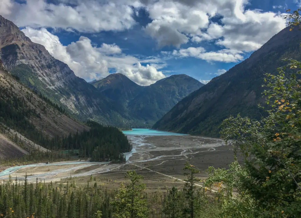
Over 100 years ago the Robson glacier extended over Robson Pass into Adolphus Lake. The glacier has retreated, leaving a flat plain behind. However, the glacial sediments remain and give Adolphus Lake its bright blue colour.
Directions:
From the Berg Lake campground follow the main trail past Rearguard and Robson Pass campgrounds. You’ll cross the border from Mount Robson Provincial Park into Jasper National Park. (And therefore from BC into Alberta. Which means you’ll also cross from Pacific time into Mountain time!)
The lake lies just over the border. It’s not directly glacier fed and pretty shallow, which makes it the best bet for swimming near Berg Lake. However, I hear it’s still pretty cold.
Final Thoughts
So there you go. Aaaalll the info about the Berg Lake Trail. It’s such a beautiful place: Go make your reservations now!
READ NEXT:
- What to Pack for the Berg Lake Trail
- 11 Best Backpacking Trips in the Canadian Rockies
- BC Backpacking Reservation Dates You Need to Know
- How to Make Backcountry Camping Reservations in BC
- How to Stay Warm in a Tent: Over 40 Tips
- 30 Best Backpacking Trips in BC


- 10 Best Things to Do in Saskatchewan - March 22, 2026
- The Best Things to Do in Saskatoon - March 17, 2026
- Grasslands National Park Travel Guide - February 4, 2026
john coltman
Tuesday 20th of September 2022
What a useful and informative description! Well Done. I wonder when the walk to Berg Lake will be re-opened. I might go again ( hope, wish). There's an incredible pic of Berg Lake and Robson from the Mumm Basin in British Columbia Mazgazine Fall 2003. To see it on a clear day is pretty special!
Robert Szypulski
Tuesday 10th of August 2021
Sorry for last post. I found in the blog where it's NOT for sleeping in.
Robert Szypulski
Tuesday 10th of August 2021
Is the Hargreaves Shelter available for overnight stays?
Taryn Eyton
Wednesday 11th of August 2021
Hi Robert, The Hargreaves shelter is for day use only. You are not allowed to sleep in it.
Sophia
Sunday 27th of December 2020
Hi Taryn, What a great post! Thank you so much for taking time and sharing all this information, this was very interesting and helpful. I have a question, though: are there any exposed steep sections on this hike to Berg Lake, e.g. steep narrow sidewalks along exposed scree slopes, etc? Any scrambling involved? I have some issues with being exposed to heights while on narrow paths, particularly going down. Any information would be greatly appreciated! Thank you, Sophia
Taryn Eyton
Monday 28th of December 2020
Hi Sophia. From the trailhead to Berg Lake there is definitely no scrambling - the trail is very well constructed. There are a few places with steep drop offs near the waterfalls, but if you don't walk near the edge, it's not too bad. On the trail up to Snowbird Pass there are also some steep drop offs and one section where you will need to use a fixed chain to help you up. One member of our group decided the chain was too scary for them and didn't go up (they don't like steep drop offs either) but the rest of us were fine as we went up slowly and carefully.
Luiza
Sunday 27th of September 2020
Hi Taryn, thank you so much for this amazing post. I am planning this hike for next year and wondering if you know how many 2-3 person tents can fit in a tent pad. Plan is to stay: 1 nt in Whitehorn, 2 nts in Berg Lake and 1 nt in Kinney. Thanks in advance.
Taryn Eyton
Monday 28th of September 2020
There are wooden platforms at Berg Lake and earthen pads with wooden sides at Kinney. The tent pads are small and you'd only be able to fit one 2 or 3 person tent on each pad in most places (they aren't all the same size). Some of the pads are small enough that a 4 person tent might not fit. I would plan on one tent per pad unless both tents are 1 person tents.