
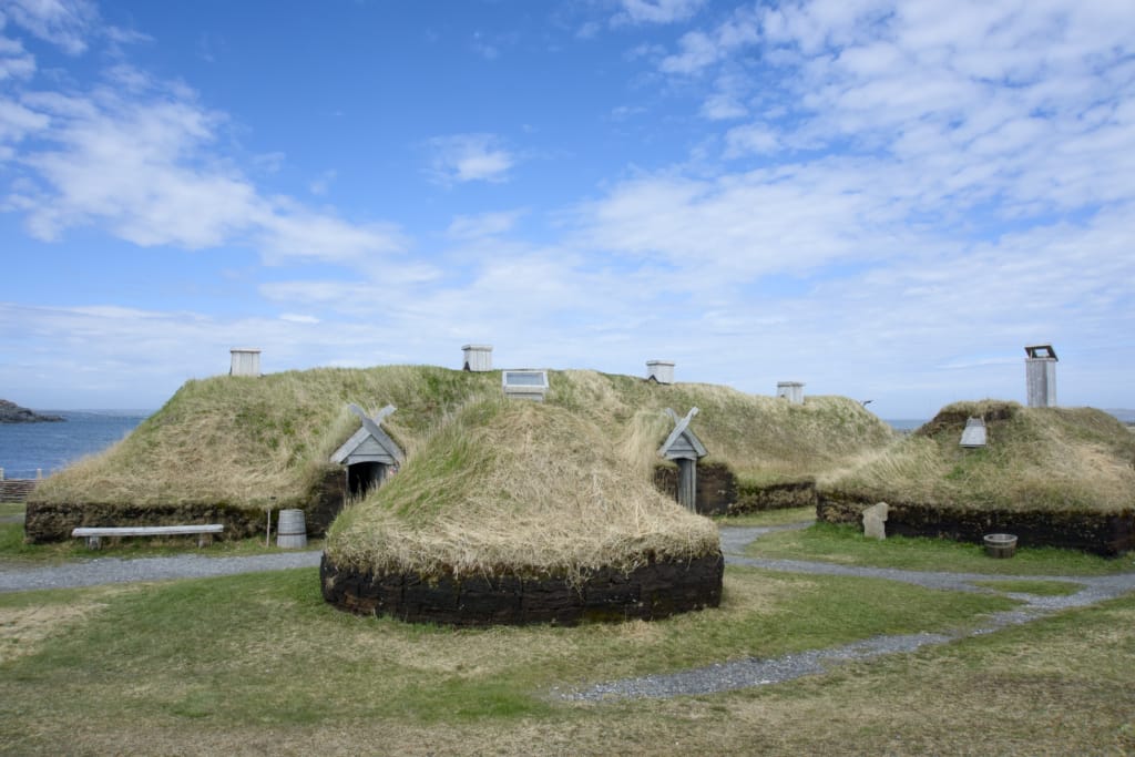
Over twenty years ago, I went to Newfoundland for the first time. It was a fly-by-seat-of-my-pants trip with no set plans, so we ended up spending two and a half days on the Great Northern Peninsula, mostly to visit L’Anse aux Meadows National Historic Site. That wasn’t enough time, so I vowed to come back!
Recently, I spent six days road-tripping up and down the Great Northern Peninsula, and I STILL feel like I haven’t seen everything! Most people know the Northern Peninsula as the home of the Viking archaeological site at L’Anse aux Meadows (the first Europeans in the Americas – they beat Christopher Columbus by almost 500 years!). However, if you dig a little deeper, you’ll find there is so much more to see.
The main reason for my June visit to the peninsula was to attend the iceberg festival. While Newfoundland is famous for Iceberg Alley, the Northern Peninsula is actually the most reliable place to see them. And the same currents that bring the icebergs are also home to tons of whales!
Like other parts of Newfoundland and Labrador, the Great Northern Peninsula has tons of cute small towns, great museums and historic sites, and gorgeous hiking. But since the peninsula is less travelled, they all feel a bit off-the-beaten-path, in the best way. The real stand-out for me was the two days I spent staying at the Quirpon Lighthouse Inn – it’s a former lighthouse keeper’s cottage on an isolated island!
So many people visit Newfoundland and miss the Great Northern Peninsula. And that’s a real shame. You’ll experience the real Newfoundland if you drive up the rugged coastline, through the gnarled forests, and past galloping moose to the remote towns of the Northern Peninsula. It’s a 400-km-long road trip that can be completed in about five hours without stops… but I recommend spending 4 to 6 days to see it all!
I’ve put together a complete Great Northern Peninsula, Newfoundland travel guide for you. It includes:
- A Great Northern Peninsula Quick Planning Guide: all the basics in one place
- A map of the Great Northern Peninsula that shows all of the places I mention in this post.
- Best things to do on the Great Northern Peninsula: small towns, museums, hikes, icebergs, and more
- Where to eat on the Great Northern Peninsula: My picks for the best restaurants and cafes
- Where to stay on the Great Northern Peninsula: The hotels and guesthouses I stayed at and recommend.
- Great Northern Peninsula Travel Tips: How to get there? How long to spend? What’s the weather like? And lots more.
- Great Northern Peninsula FAQ: The answers to your most commonly asked questions
Hey there: Thanks so much to Newfoundland and Labrador Tourism and Go Western Newfoundland for hosting me on my recent trip. My previous trip was at my own expense. All opinions in this post are my own. Some of the links in this post are affiliate links, which means I earn a small commission at no cost to you. Thanks for your support! – Taryn
This is a sensitive wilderness area. Learn how to Leave No Trace to keep the wilderness wild. Make sure you are prepared by bringing the 10 Essentials. Get ready for adventure with this checklist of things to do before every hike.
Table of Contents
Great Northern Peninsula Quick Planning Guide
Location: Northern Newfoundland and Labrador
Nearest major airport: Deer Lake (YDF)
Main route: Viking Trail (Highway 430)
Largest town: St. Anthony
Best time for icebergs: Late May to early July
Best time for whales: Mid-June to mid-August
Ideal trip length: 4 to 7 days
Must-see stops: L’Anse aux Meadows National Historic Site, iceberg and whale boat tours, Quirpon Island
Great Northern Peninsula Map
To help you plan your trip and find your way around, I created a custom Google Map of Newfoundland’s Great Northern Peninsula for you. It includes every place I mention in this post.

Things to do on the Great Northern Peninsula in Newfoundland
Besides the bits about icebergs and whales, I’ve organized the things to do section in the order you would visit things on the Great Northern Peninsula road trip as you drive from south to north.
Heads up: It’s 433 kilometres from Deer Lake to St. Anthony, not including side trips, so allow plenty of time!
Best Places to See Icebergs on the Great Northern Peninsula
One of the big reasons to visit Newfoundland’s Great Northern Peninsula is that it’s the best place in the province to spot icebergs. It sits at the start of Newfoundland’s “Iceberg Alley”, which stretches along Newfoundland’s northern coast as well as along Labrador’s coast.
Since the Great Northern Peninsula is the northernmost point on the island of Newfoundland, it gets the most icebergs as they drift south from Greenland. As well, the craggy geography of the peninsula means that icebergs often get pushed into its main bays and coves, where they stay until they melt.
You can definitely see icebergs elsewhere in Newfoundland, but for the best chance of seeing tons of them, you have to go to the Great Northern Peninsula. They even have an annual Iceberg Festival each year in early June that involves all types of local businesses and community groups.
The best time to see icebergs in this area is between late May and early July. Many are easy to spot from land in coastal communities like Conche, St. Anthony, and Saint Lunaire, where the bergs get stuck in coves.
But for guaranteed close-up sightings, book a boat tour. I did a zodiac tour with Linkum Tours in Quirpon. We got really close to an iceberg and our guide, Ed, shared lots of great stories about local history. I’ve also heard good things about Northland Discovery – they run tours out of St. Anthony.


Whale Watching on the Great Northern Peninsula
Prime whale watching season on the Great Northern Peninsula is between late June and late August. I visited in early June, so I was too early to see the whales. However, I’ve heard that sightings of humpback whales are common, and that you can also see minke whales, fin whales, Atlantic white-beaked dolphins, and lots of seabirds.
The same companies that run iceberg boat tours (listed above) are also your best bet for whale watching.

Things to Do Along the Viking Trail (Highway 430)
The bulk of the Great Northern Peninsula is the 400 km drive along Highway 430, also called the Viking Trail, between Deer Lake and St. Anthony. Most of the highway hugs the coast, passing tiny villages with few services. Below, I’ve got details on the highlights in this section.
Gros Morne National Park
If you’re road-tripping up the Great Northern Peninsula along the Viking Trail, you’ll pass right through Gros Morne National Park. It’s a huge park with lots of hikes, historical sites, and viewpoints.
It’s one of my favourite places in Newfoundland, and I recommend spending a few days there. Check out my guide to Gros Morne National Park for a run-down of everything there is to do and see.
If you are just driving through the park on your way north, there are a few great viewpoints alongside the highway that are worth a quick photo stop, including Lobster Cove Head Lighthouse, Green Point Geological Site, and the viewpoint at the beginning of the trail to Western Brook Pond.
Or spend more time in the area to do one of the hikes on my list of the best hikes in Newfoundland.


The Arches Provincial Park
The drive up the coast past Rocky Harbour is along the coast, with frequent glimpses of the ocean through the wind-bent branches of the spruce trees. These gnarled tree formations are known as tuckamore.
If you’re looking to stretch your legs, it’s worth stopping at The Arches Provincial Park, a few minutes north of Gros Morne National Park. This tiny park is right next to the Viking Highway and is home to a huge rock formation that sits along the beach. It’s a short walk down the bank and along the cobbled beach to the arches.
It looks like a chunk of land has broken away, lodged itself just offshore, and then been hollowed out. You can walk through the wave-carved arches under the conglomerate rock. Apparently, there used to be four arches, but one collapsed, so now there are just three.


Port au Choix National Historic Site
Port au Choix is a short detour off of Highway 430, but it’s worth it. It’s a cute fishing town on a nearly treeless peninsula with a ton of history… really old history! While the town’s name comes from Basque fishermen in the 1500s, the real reason to visit is the archaeological site that dates back over 5000 years.
In the 1960s and 70s, archaeologists from Memorial University discovered burial sites from the Maritime Archaic Peoples and evidence of Dorset Paleo-Eskimo dwellings. Both are ancient Indigenous groups, with the former living 7500 to 3500 years before present and the latter 2000 to 1300 years before present.
The entire peninsula is dotted with important archaeological sites you can visit, and it is a National Historic Site of Canada. It’s best to start at the visitor centre to learn about the various Indigenous groups and the timeline of when they were at Port au Choix.
Next, I recommend heading out to Point Riche Lighthouse. It’s a gorgeous windswept spot, and you might even spot caribou! I was so excited to see a pair of caribou feeding and seemingly posing for photos. Just don’t get too close – they are wild animals and deserve our respect. There’s also an archaeological site here.
There are several other sites to visit on the peninsula – you could easily spend a whole day here. Unfortunately, due to a majorly delayed flight that shortened my itinerary, I didn’t have the time!
I really wanted to do the short hike to Phillip’s Garden to see the Dorset archaeological site and to hike through the limestone barrens to spot unique plants. I also wish I had time to visit the French Rooms Cultural Centre and the French Bread Oven to experience the region’s more recent French history. Next time!


Flowers Cove
Another great stop along the Viking Trail is Flowers Cove where you can make a short stop to walk the short and flat Thrombolites Trail. The trail leads to the thrombolites, which are unique 650 million-year-old “living” fossils. It’s one of only two places in the world to see these unique rocks. (The other is in Western Australia.)
The thrombolites are actually the remains of ancient ocean microbes photosynthesizing their food, preserving it in calcium carbonate from the nearby limestone. They look like large, pillowy rocks. You can view the thrombolites by following the walking trail across the covered bridge and along the waterfront.
The nearby Flowers Cove Lighthouse is also quite picturesque. It sits on the end of a low peninsula and can be seen from various places around the cove.


Roddickton and Conche Area
Most visitors to the Great Northern Peninsula stick to Highway 430 and therefore the western side of the peninsula. However, it’s worth venturing over to the east side of the peninsula on Highways 432, 433, and 434. The drive east from Highway 430 to Roddickton is about 75 km and takes a little over an hour. From Roddickton, it’s another 30 minutes northeast to Conche.
I think it is especially worthwhile to visit this area during iceberg season because there are often icebergs close to land in the bays.
Underground Salmon Pool
The Underground Salmon Pool near Roddickton is one of the most bizarre geological formations I have visited. The waters of Beaver Brook pass through a series of underground channels and caves.
In late summer, salmon gather at the entrance to the main tunnel, then pass through it on their way into a pond. From there, they follow underwater channels further upstream into the main part of Beaver Brook.
When I visited in spring, there weren’t any salmon, and the water levels were really high thanks to snowmelt. The water was gushing up to the top of the main tunnel. And in the pond, the water was violently bubbling up in the centre, showing where the underground passage comes into the pool. It was amazing to watch.
The Underground Salmon Pool is located south of Highway 433, about 15 km outside of Roddickton. There is no cell service, so be sure to look up directions in advance. To get to the salmon pool, you’ll need to follow a bumpy gravel road for 2.5 kilometres to the trailhead. If you go slowly, it’s fine in any car.
From there, you can hike to the pool and back on a 2-kilometre loop trail that is mostly flat. Allow 30 to 45 minutes for the hike.
For better directions and lots of local info, book a hiking package with the Mayflower Inn in Roddickton. It includes a custom app for a self-guided tour of the Underground Salmon Pool.


Roddickton, Bide Arm, and Englee
The three small towns of Roddickton, Bide Arm, and Englee sit at the end of Highway 433. It’s worth detouring to the end of the Highway during iceberg season to see if you can spot icebergs in the bays and inlets.
The towns themselves are small, but cute and have lots of photo opportunities along the coastline.
There are also several short hiking trails in the area. I only had time for one: Barr’d Island Trail. It’s a short loop trail around the small island, which is joined to the mainland via a gravel causeway. The hike starts with a climb up an impressive set of wooden stairs. At the top, it meanders along the clifftops to several great viewing platforms.
The trail is only about 1 km long with 65 m of elevation gain. Plan to spend about 30 to 45 minutes on the trail, enjoying the views and taking photos.


Conche
The tiny town of Conche is another great spot for iceberg viewing at the end of Highway 434, about 30 minutes from Roddickton. It sits on a peninsula, so you can view icebergs both in the town’s main harbour and in Crouse Harbour just to the north.
The town is the site of a 1942 plane crash, and you can still walk around the wreckage on the edge of town. There’s also a small exhibit about the crash at the French Shore Interpretation Centre. (More about that below.)
There are also several short walks in the area. Don’t miss Sailor Jack’s Hill viewpoint on the highway just outside of town. Walk up a few flights of stairs to the wooden observation deck for a 360-degree view of Conche, Crouse, and Highway 434.
I also enjoyed the flat Captain Coublongue Trail in Crouse. It follows the shoreline out to a viewpoint at the edge of Crouse Harbour. It’s about 3 km round-trip out to the viewpoint. Allow about an hour.
Another trail I didn’t have time for (but wish I did) is the Glass Hole. It’s a more challenging 7 km loop out to the end of the Conche Peninsula to a dramatic fissure in the rocks, known as the Glass Hole. You can scramble down into the sea cave with the help of ropes. Allow 3 to 4 hours for the hike.


French Shore Interpretation Centre
The main reason to visit Conche is the excellent French Shore Interpretation Centre. This area was originally settled by French fishermen. The little museum in Conche has some great exhibits that explain the area’s long and unique history.
However, the best part of the French Shore Interpretation Centre is the French Shore Tapestry. The 216-foot-long tapestry was hand-embroidered by a team of local women under the direction of French artist Jean Claude Roy. It’s so long that it snakes around the display room. The tapestry is meant to mimic the style of the famous Bayeux Tapestry and tells the story of the French Shore from the time of Indigenous people up to the present.
If you visit, be sure to talk to the museum’s curator, Joan Simmons, who was the program director of the tapestry project. She gives a great tour that includes lots of interesting stories about the area’s history and the production of the tapestry.


St. Anthony Area
With a population of about 2,200, St. Anthony is the largest town on the Great Northern Peninsula, making it the area’s economic hub and a good place to base yourself. The surrounding towns of Saint Lunaire-Griquet, Quirpon, L’Anse aux Meadows, and Raleigh are all a short drive away and have lots to offer visitors.
Fishing Point Park
The main attraction for visitors to St. Anthony is Fishing Point Park. It features the picturesque Fox Point Lighthouse and several walking trails with great views of St. Anthony Harbour. It’s also a great place to spot icebergs. Next to the lighthouse, you’ll find the excellent Lightkeepers Cafe and a cute souvenir shop.
Several hiking trails branch off from the park, all part of the bigger Great Northern Trail. I wished I had time to tackle the Cartreau Point Trail that heads up to a great viewpoint next to a communications tower before heading along the top of ocean-side bluffs.


Grenfell Interpretation Centre
The main museum in St. Anthony is the Grenfell Interpretation Centre. It tells the history of Dr. Wilfred Grenfell, a very important figure in Newfoundland’s history. He was a British doctor who helped found the area’s first hospitals as well as schools and social services in the 1800s and early 1900s. The museum also has a great gift shop.

Raleigh
Not that many visitors had out to Raleigh, even though it is only about 20 minutes from St. Anthony on Highway 437. Pro tip: Locals pronounce it “rally”.
The village is spread out along the shores of Ha Ha Bay. It has an interesting open-air historic village with fishing rooms and stages restored to how things would have looked in the 1940s.


Burnt Cape Ecological Reserve
I visited Raleigh to hike at Burnt Cape Ecological Reserve – the reserve is right at the edge town town and sits on a rocky peninsula that looks a bit like a moonscape. The entire surface is fine gravel, with clumps of hearty bushes, grasses and flowers in the low spots that have enough moisture to develop soil.
If you have a 4×4, you can drive most of the way down the peninsula on a rough gravel road. Since we were driving a rental car and didn’t want to void our rental agreement, we walked. The trail/road is about 4 km each way. At the end of the road, a short trail leads out along the edge of the cliff to a striking rock shelf viewpoint. Allow 2 to 2.5 hours for the hike.
If you’re a plant nerd like me, you’ll love spotting tenacious flowers blooming in the gravel. Burnt Cape is home to hundreds of unique arctic plant species, some of which grow only on the cape! If you want to learn more about the plants, I like the Seek app. It can identify plants through photos and videos and keep track of which species you have seen before.


Saint Lunaire-Griquet
The twin towns of Saint Lunaire and Griquet are located a few minutes north of St. Anthony along Highway 436. Pro tip: In Newfoundland English, Griquet rhymes with “cricket”. Don’t try to pronounce it as a French word – locals will laugh (good-naturedly).
Like others in the area, Saint Lunaire and Griquet are cute fishing towns. Saint Lunaire Bay is large with lots of coves and islands, so it’s a great place to spot icebergs.
Saint Lunaire is home to The Dark Tickle Company. It is named for a nearby channel between islands, which Newfoundlanders call a tickle. You can find their berry jams, teas, and condiments at gift shops all over Newfoundland. But it’s worth visiting their shop to see their full selection.


L’Anse aux Meadows
Besides icebergs, the primary reason many visitors travel all the way up the Great Northern Peninsula is to visit the Viking site at L’Anse aux Meadows National Historic Site.
In 1960, Norwegian archaeologists discovered ridges in the village of L’Anse aux Meadows. Excavations proved that these ridges were the remains of a Viking settlement from the 11th Century, meaning that the Vikings reached North America 500 years before Christopher Columbus.
Today, you can visit to see the archaeological site. They also have several reconstructed buildings you can go inside and explore. The best way to see the site is to take a walking tour with a Parks Canada guide. It’s included with site admission.
If you want to go for a hike, the Birchy Nuddick Trail starts from the historic site. It’s a 3 km loop that follows the coast out to a viewpoint with a pair of iconic Parks Canada red chairs. From there, the trail heads inland on boardwalks past a pond with a side trail to the viewpoint, before finishing in the parking lot. Allow about 1 hour for the walk.


Norstead
A few minutes away from the National Historic Site is the recreated Viking village of Norstead. It has several reconstructed period-appropriate buildings, including a Chieftain’s hall, a church, and a blacksmith shop, all staffed with costumed interpreters who can tell you about what Viking life was like.
The stand-out attraction is the full-scale 54-foot-long replica of the Snorri, a Viking ship. This replica ship sailed to Newfoundland from Greenland in 1998 with a crew of nine to replicate Leif Erikson’s historic voyage to Newfoundland.


Quirpon Island
Before planning my trip to Newfoundland’s Great Northern Peninsula, I hadn’t heard of Quirpon Island. But as soon as I found out about it, I knew I had to stay there! (Pro tip: It’s pronounced “kar-poon” because Newfoundland English does fun things sometimes.)
Quirpon Island is a small island just off the north coast of the Great Northern Peninsula, making it the northernmost point on the island of Newfoundland. (Well, it would be if it wasn’t an island, but you know what I mean!)
At the northern tip of the island is a lighthouse, and next to the lighthouse is the Quirpon Lighthouse Inn. Yes, you can book a stay in old lighthouse keepers’ cottages! When the Coast Guard automated the lighthouse in 1998, Ed English of Linkum Tours bought the two cottages next to the lighthouse and opened the inn.
Your stay begins with a zodiac ride across Quirpon Harbour. Ed can take you all the way around the island to a narrow and choppy cove near the lighthouse. Or you can do what we did and disembark on the southern part of the island at Grandmother’s cove, and then hike 5 km to the lighthouse while Ed brings your luggage around to the cove and up to the lighthouse.
The inn has several rooms spread across the two cottages, and communal meals are included. We loved chatting with the other guests over dinner. The rooms are rustic, but cute. There are also two observatory buildings with windows to watch for whales and icebergs since the island sits at the intersection of several currents.
Quirpon Island is mostly sub-arctic barrens with bountiful berry bushes blanketing the rolling hills. Since it is exposed to the Atlantic, it can be very windy, and the weather is unpredictable. There are several trails on the island, making it a great spot for hiking. Ed also offers a daily zodiac tour around the island where he tells stories about local history and takes you to icebergs.
We spent two nights on the island, which I recommend. It’s enough time to hike, explore the island, take a zodiac tour, and just chill out in a beautiful and remote place.
If you don’t want to stay overnight, you can also arrange for Ed to take you over on the Zodiac for a day visit to go hiking.


Where to Eat on the Great Northern Peninsula
Many of the towns on the Great Northern Peninsula are tiny, so there aren’t that many restaurants. You’ll also want to check the opening hours for restaurants since some aren’t open seven days a week or may operate on limited hours.
Many towns have small grocery stores or general stores where you can pick up snacks or ingredients to cook if your accommodation has a kitchen.
Here are my personal recommendations for restaurants in each region of the Great Northern Peninsula.
Where to Eat in Gros Morne
If you’re driving the Viking Trail (Highway 430), it’s worth detouring into the towns of Norris Point and Rocky Harbour for food. I’ve spent a lot of time in Gros Morne over the years, so here are a few places I like:
The Black Spruce Restaurant: Located at Neddies Harbour Inn in Norris Point, The Black Spruce has a carefully curated fine dining menu that highlights local seafood and meats. They also do delicious packed lunches you can enjoy on the hiking trails.
Old Store Cafe: This little cafe in Norris Point is a great spot for coffee, baked goods, and lunch. Try their “Gull Shit muffins” – they are chocolate muffins topped with cream cheese. Delicious!
Cat Stop Pub: The Bonne Bay water shuttle docks right next to Cat Stop Pub in Norris Point, which has a huge waterfront patio. It’s a good place for a beer and casual pub food.

Buoy & Arrow: This Indigenous-owned restaurant in Rocky Harbour has lots of locally-sourced game meat and seafood on the menu. I had an amazing moose burger. Their menu gives the names for dishes in both English and Mi’kmaq.
Chanterelle’s: I’ve eaten at this restaurant inside the Sugar Hill Inn twice and both times were stand-out meals. It offers fine-dining and exceptional food without too much pretension. Trust me: get the seafood cakes.

Where to Eat in the Roddickton and Conche Area
There aren’t very many restaurants in these tiny towns, and most of them weren’t open on the days we visited, so I don’t have many recommendations here. However, I highly recommend one place:
Boutitou Coffee and Food: We visited this tiny food truck in Conche during one of the first few days it was open. They make espresso-based coffees and have incredible sandwiches. The picnic table next to the truck had insane views of the icebergs in Conche Harbour.

Where to Eat in the St. Anthony Area
Since this part of the peninsula sees more tourists, it has more restaurants. However, you’ll still need to keep opening hours in mind. Here are the places I ate at and recommend:
Lightkeepers Cafe: This restaurant sits inside the former Lighthouse keeper’s house in Fishing Point Park in St. Anthony. It has great views of the harbour (and icebergs) and serves lots of traditional dishes like fish cakes and salmon.

Flavour Crisp Chicken Coop: There are several fast food places in St. Anthony, but the locals all seem to prefer the juicy fried chicken at Flavour Crisp Chicken Coop and I agree. Pro tip: Get the fries Newfoundland-style – smothered in dressing and gravy.
Cafe Nymphe: This cafe is on the upper level of The Dark Tickle Company’s shop in Saint Lunaire. They make great breakfast (with lots of berries) as well as sandwiches and coffee. They also have a dinner menu.
The Daily Catch: Some of the tables at this Saint Lunaire seafood restaurant have great views of the water. I had the best fish and chips of my trip here, which is saying a lot – they love fish and chips in Newfoundland!
The Norseman Restaurant: This is the closest restaurant to L’Anse aux Meadows National Historic Site, but thankfully, the food is good. Their small menu offers sandwiches and soups at lunch and larger mains at dinner. From talking to other visitors, it seems like they are one of the only restaurants in the area that is easily able to cater to those with dietary restrictions like gluten-free.

Where to Stay on the Great Northern Peninsula
Most of the larger towns on the Great Northern Peninsula have hotels. There are also cute guesthouses and cottage rentals in many of the smaller towns. Here are a few places I recommend.
Deer Lake Horizon Hotel: I’ve stayed at this hotel a few times on trips to Western Newfoundland. It’s close to the airport and has a shuttle that meets all late-night flights, so it’s easy to get to bed quickly. It’s comfortable and clean with large rooms. Check rates.

Gros Morne Base Camp: I spent four nights at Gros Morne Base Camp’s Burnt Hill Cabins on my fall visit to the National Park. These rustic but cute cabins felt like home with little kitchens and full living rooms. They are also an easy walk to the waterfront in Norris Point or the Old Store Cafe for a morning coffee. Check rates.

Mayflower Inn: The owners of this sprawling family-run inn in Roddickton, Shanna and Trevor, went out of their way to ensure we had a great stay. They cater to hunters in the fall, but in spring and summer, they can set you up with a hiking package that includes meals and a custom app with local info about three popular hiking trails. Check rates.

Burnt Cape Cabins: These cute cabins in Raleigh are close to the harbour and have kitchens, so you can cook your own meals. Ours had a great view of sunset over the Burnt Cape Ecological Reserve. Check rates.

Raleigh Rooms: We also stayed at Raleigh Rooms in Raleigh. The Puffin Suite had great views of the harbour and Burnt Cape, along with really cute puffin decor. The owners also run Taylor Crafts, a gift shop featuring unique bone, stone, and antler carvings. Check rates.

Quirpon Lighthouse Inn: An unforgettable remote stay in a former lighthouse keeper’s cottage. Perfect for going off the grid and getting a sense of what a lighthouse keeper’s life might have been like decades ago. Truly a bucket list stay. Check rates.

Grenfell Heritage Hotel & Suites: Popular and well-reviewed hotel in downtown St. Anthony. Some suites have kitchens and balconies that overlook the harbour. Check rates.
Great Northern Peninsula Travel Tips
How Do You Get to the Great Northern Peninsula?
Newfoundland’s Great Northern Peninsula stretches for over 400 kilometres from Deer Lake to the St. Anthony area. If you are arriving by air, you can fly to Deer Lake from airports in eastern Canada and then drive up the peninsula.
It’s also possible to fly into St. Anthony from St. John’s, but flights are less frequent, and there are fewer car rental options. (However, the St. Anthony airport code is YAY, and honestly, I’m tempted to fly there just for that!)
Most visitors to Newfoundland’s Great Northern Peninsula do so on a road trip, driving up the peninsula and back down again. However, some visitors also take the ferry from St. Barbe over to Blanc-Sablon and then make the long drive through Labrador or take the ferry to get to the main highways in Quebec.
There is no public transportation on the Northern Peninsula, so you will need to rent a car in Deer Lake or St. Anthony and drive yourself. You’ll also want to have a car to get around the peninsula since most attractions are not within walking distance.
Rental cars are in short supply during the summer months, so I recommend booking your car as far in advance as possible. Book your car before you book hotels or tours, since your trip won’t happen if you can’t get a car! I recommend using Discover Cars for rentals since you can use it to compare prices across rental car providers.

Northern Peninsula Driving Tips
Navigation
In general, the Highways and major roads are well-signed and easy to navigate, but Google Maps can be helpful. However, the small towns can be confusing with few road signs and lots of errors on Google Maps. Use caution when driving on gravel roads in small towns – you might be on someone’s driveway or on a ATV trail, even though Google Maps shows it as a road!
Supplies
The roads on the Northern Peninsula are remote, and many areas do not have cell phone service. There can be big gaps between towns. Don’t let your gas tank get too low since it might be a while until you can fill up! I recommend keeping water and snacks in the car, too!
Road Conditions
The main highway, Highway 430, is usually in fairly good condition, but it does have sections with bumps and potholes. However, it is a two-lane highway without a lot of passing lanes, so you will need to use care when passing and pull over if you are impeding traffic.
The secondary highways, especially Highway 432 to Roddickton and Conche, are very bumpy with lots of potholes and areas where water pools when it rains. You will need to go a little slower on these sections.
Moose
The Northern Peninsula is also known throughout Newfoundland for its high moose population… and that’s saying something since Newfoundland has a lot of moose – about 1 moose for every 4 people! Moose are a major road hazard, and people die every year in collisions with moose.
Avoid driving at night or near dusk and dawn because that’s when most moose accidents occur. There are warning signs in areas with high moose populations, so slow down when you see them. If you see someone stopped on the highway or flashing their lights, slow down – the other driver probably spotted a moose.
We spotted six different moose on our drive on the Northern Peninsula, one of which ran out into traffic quite close to our car! Read through the Newfoundland Department of Transportation’s Moose Advisory info for more tips on driving in moose habitat.

Best Time to Go
The best time to go to Newfoundland’s Great Northern Peninsula is between late May and early September. That’s the time of year with the best weather (more on the weather below) and when most tourist businesses are open.
The peak of iceberg season is from late May to early July, so that’s the best time to visit if you want to see icebergs. Don’t miss the Iceberg Festival in early June.
If you want to see whales, the best time to visit the Northern Peninsula is between mid-June and mid-August when the humpbacks come to feed on capelin.

How Many Days for a Great Northern Peninsula Road Trip?
I’ve been to the Great Northern Peninsula twice. On my first trip, we spent three days, which really wasn’t enough. On my second trip, we spent six days, which was closer to the right amount of time. However, I would have liked to stay a little longer to do more hiking.
In general, I think most people should spend at least four days on the Great Northern Peninsula. That’s enough time for a big day of driving on days 1 and 4 to get to and from the northern end of the peninsula, plus time for highlights like L’Anse aux Meadows, Port au Choix, and an iceberg tour. If you want to spend time on Quirpon Island or you like hiking, add a few more days.

Suggested Great Northern Peninsula Itineraries
Here are my recommendations for the best Great Northern Peninsula itineraries. If you’re in a hurry, use my 4-day itinerary. But I really recommend using my longer 6-day itinerary since it gives you more time and visits worthwhile hidden gems like Quirpon Island and Conche.
Quick 4-Day Great Northern Peninsula Itinerary
Day 1: Drive from Deer to Lake to St. Anthony with a stop at Port au Choix National Historic Site
Day 2: L’Anse aux Meadows National Historic Site and St. Anthony
Day 3: Iceberg/whale boat tour and a hike at Fishing Point Park in St. Anthony or Burnt Cape Ecological Reserve
Day 4: Drive from St. Anthony to Deer Lake with stops at Flowers Cove and Arches Provincial Park
The Perfect 6-Day Great Northern Peninsula Itinerary
Day 1: Drive from Deer Lake to Port au Choix with stops in Gros Morne National Park.
Day 2: Roddicton and Conche
Day 3: Iceberg/whale boat tour and a hike at Fishing Point Park in St. Anthony or Burnt Cape Ecological Reserve
Day 4: St. Anthony, L’Anse aux Meadows National Historic Site, and then boat to Quirpon Island
Day 5: Quirpon Island
Day 6: Drive from Quirpon Harbour to Deer Lake with stops in Flowers Cove and Arches Provincial Park

Great Northern Peninsula Weather
Since you’ll be in the northernmost part of Newfoundland, don’t expect warm weather, especially in May and June.
Typical summer temperatures in the St. Anthony area are between 3 and 17°C (37 and 62°F). It’s often very windy, and it can be rainy or foggy at any time.

What to Pack for the Great Northern Peninsula
Rain Jacket
Since you’ll likely be spending a lot of time outdoors, be sure to bring a good rain jacket. I like the Outdoor Research Aspire Jacket since it is lightweight, breathable and very waterproof. (The men’s version is the Outdoor Research Foray.) If you’re on a budget, the MEC Aquanator or REI Rainier jackets are both great value.
Fleece or Lightweight Puffy Jacket
It can be chilly, so bring a fleece or lightweight insulated puffy jacket to layer under your rain jacket.
Toque and Gloves
You’ll also want a toque and gloves. If you don’t bring your own, you can buy cute knitted toques and mittens at most souvenir and craft shops.
Waterproof Hiking Boots
I also recommend waterproof hiking boots since you might be out in the rain, and the ground can be soggy. I’m a devoted Salomon girlie, so I recommend the Salomon X Ultra Mid Gore-Tex hiking boots. They are mid-cut rather than high-cut, so they aren’t too aggressive, and they have a forgiving fit that works for all but the widest feet.
Hiking Clothing
For hiking or outdoor tours, I recommend a long-sleeved merino wool thermal top. I like the ones from Smartwool. I also recommend a pair of lightweight synthetic hiking pants. Make sure the ones you get have a water-resistant DWR finish. My favourites are the Mountain Hardwear Dynama Pants since they have a comfortable pull-on waistband that fits a variety of body types.
Camera, Power Bank and Binoculars
Since the point of your trip is to see the scenery, don’t forget a camera, a power bank, and binoculars. I use a tiny pair of Pentax binoculars that are small enough to fit in my pocket but have enough magnification to be able to see details at long distances.
Motion Sickness Medication
If you plan to take a boat tour, bring some motion sickness medication since the Atlantic Ocean can be very bumpy.
Backpack With Rain Cover
Don’t forget a small backpack to carry your essentials on hikes and tours. I like to pack a simple waterproof backpack cover, so I don’t have to worry about my gear getting wet in the rain. I also store electronics and other essentials inside a small dry bag in my backpack.


Cell Phone Service on the Great Northern Peninsula
Cell phone service on the Great Northern Peninsula can be spotty. You will usually have good service in towns, but as soon as you drive five minutes down the road, you are in a dead zone. Even when you do have service, you may only have a few bars, which is enough to text, but not enough to use the internet.
If you have a Canadian cell phone, you’ll get the best service if you are with Telus or Bell (or one of the providers that uses their towers, like Koodo, Public Mobile, and Virgin). You will likely have bad signal or no signal for most of the peninsula if you are with Rogers or one of their partners including Fido, Chatr, or Videotron.
For international visitors, you’ll be roaming to look for the best signal, which is usually Telus or Bell. If you buy an eSim, they typically connect to the strongest local signal, which will be Telus or Bell.
Make sure you look up Google Maps directions or download offline hiking maps from apps like All Trails or Gaia GPS before you leave a town.
Indigenous Context on the Great Northern Peninsula
The Great Northern Peninsula has a long Indigenous history, starting with the Maritime Archaic people over 5000 years ago and the Paleo-Eskimo and Dorset peoples about 4000 years ago. You can learn about both of these groups at the Port au Choix National Historic Site.
More recently, the Beothuk peoples lived on the peninsula starting about 2000 years ago, but were wiped out in the 19th century during colonization. The Mi’kmaq people started coming to Newfoundland from Cape Breton Island in the 16th century. They settled on the south and west coasts (and still live there), but did travel up the Northern Peninsula seasonally to hunt.

Great Northern Peninsula FAQ
Late May to early September offers the best weather, but June is ideal for icebergs.
Four days is enough for the main highlights (L’Anse aux Meadows, Port au Choix, and an iceberg/whale boat tour), while 6 to 7 days is better if you want to stay on Quirpon Island, visit off-the-beaten-path towns like Conche, or go hiking.
Yes. There is no public transportation for visiting the peninsula’s towns, trailheads, museums, and boat-tour departures.
The 400 km long drive from Deer Lake to St. Anthony takes about 5 hours without stops. However, plan extra time for side trips and photos. Most visitors will want to spend 4 to 7 days in the area.
The town of St. Anthony and the surrounding villages, like Saint Lunaire and Raleigh, are a good base for visiting the attractions at the far northern end of the peninsula.
June is the peak month for icebergs, but you can also reliably see icebergs from late May through early July.
Yes. In most years, you can see icebergs from roads and shorelines in Conche, St. Anthony, and Saint Lunaire-Griquet and other towns. However, it is worth doing a boat tour to get a closer look.
Mid-June through mid-August. Humpbacks are the most common species.
Yes. The scenery on the drive is stunning, L’Anse aux Meadows is an interesting historic site, and the St. Anthony area is the best place in Newfoundland to see icebergs.

Final Thoughts
For most visitors to Newfoundland, the Great Northern Peninsula is just a quick stop to visit L’Anse au Meadows, or worse, an afterthought. It deserves so much better!
I think the Viking Trail is one of the best road trips in the province. It has icebergs, whales, Viking history, rugged coastline, cute villages, great hiking, and a one-of-a-kind experience: the opportunity to stay in a lighthouse keeper’s cottage on a windswept island in the North Atlantic!
I loved my time on the Great Northern Peninsula and would love to go back to do more hiking and to experience the isolated magic of Quirpon Island again.
If you’re planning your trip to Newfoundland, check out these other posts:
